Англия в 1086 году, показаны сотни, уэпентейки и палаты
Большинство графств Англии были разделены на сотни или уэпентеки с позднего англосаксонского периода, и они, за редкими исключениями, были фактически оставлены как административные единицы в 19 веке. [1]
Графство Беркшир состояло из 20 сотен и 193 приходов, а также частей четырех других. [2] Из Национального вестника Британии и Ирландии (1868), История графства Виктория, Беркшир, том 3 (1923) [3] и том 4 (1924) [4]
Бакингемшир
Бакингемширские сотни в 1832 году
По крайней мере до времени Обзора Страшного суда в 1086 году в Бакингемшире было 18 сотен. [11] Однако было высказано предположение, что соседние сотни уже стали более тесно связаны в XI веке, так что к концу XIV века первоначальные или древние сотни были объединены в 8 более крупных сотен. [12]
Кембриджшир был разделен на 17 сотен, плюс город Кембридж . У каждой сотни был отдельный совет, который собирался каждый месяц для решения местных судебных и налоговых вопросов. В 1929 году сотни включали следующие приходы. [13] [14]
Чешир
Сотни жителей Чешира в 1832 году
Из Harris, BE, и Thacker, AT (1987). История Виктории в графстве Честер. (Том 1: Физическое состояние, Доисторическое, Римское, Англосаксонское и Судный день). Оксфорд: Oxford University Press. ISBN 0-19-722761-9 .
Для некоторых целей острова Силли причислялись к одной десятой сотни.
Камберленд
Карта Камберленда с указанием округов, 1824 г.
Камберленд был разделен на округа, аналогичные сотням. Из Национального газетира Британии и Ирландии Генуки: КАМБЕРЛЕНД, Англия – История и описание, 1868, Камберленд
Гражданские подразделения Дербишира в древности назывались wapentakes. В Domesday Survey 1086 упоминаются wapentakes Scarvedale, Hamestan, Morlestan, Walecross и Apultre, а также район Peche-fers. [16] Разделен на сотни к 1273 году. Из GENUKI Genuki: DERBYSHIRE, England – History and Description, 1868, Derbyshire (на основе Gazette 1868 года):
Хай-Пик — уэпентейк Хаместан и, возможно, район Пече-Ферс в 1086 году; уэпентейк Пек к 1273 году.
Уирксворт — вплоть до 1817 года назывался уэпентейком.
Скарсдейл
Морлстон и Литчерч — в Обзоре Страшного суда 1086 года названы Морлестан или Морлейстон уопентакейк и Литтлчерч уопентакейк [17] , а в Сотне 1273 года — Литтлчерч; к 1300 году объединены как сотня Морлстона и Литтчерча. [18]
Яблоня
Рептон и Гресли — в 1274 году образовали отдельные поместья Репиндон и Грезелег (принадлежавшие королю и наследникам графа Честера соответственно); в 1086 году — большое поместье Уэйлкросс.
По данным essex1841.com, в переписи 1841 года в Эссексе также была зафиксирована сотня Харвича, которую История округа Виктория относит к Тендрингу.
Глостершир
Глостерширские сотни в 1832 году
Тридцать девять сотен, упомянутых в Обзоре Страшного суда, и тридцать одна сотня Списков сотен 1274 года очень сильно отличаются по названию и размерам как друг от друга, так и от двадцати восьми сотен сегодняшнего дня. Из Национального справочника Британии и Ирландии Genuki: Miscellaneous Places, Gloucestershire, Gloucestershire
Уитстоун (верхний и нижний дивизионы) – к 1220 году поглотили сотню Блэклоу.
В герцогстве Ланкастер (Глостершир) количество воль иногда исчислялось сотней.
Гэмпшир
В Обзоре Страшного суда упоминается 44 сотни в Гэмпшире [23], записанных как HanteScire и сокращенно как Hante . [24] К XIV веку их число сократилось до 37. Сотни Восточной Медины и Западной Медины на острове Уайт упоминаются в 1316 году. Остров Уайт получил собственный совет графства в 1890 году и стал полноценным церемониальным графством в 1974 году.
Hampshire has in the past been named Southamptonshire and is so recorded in the Commonwealth Instrument of Government, 1653. The name of the administrative county was changed from 'County of Southampton' to 'County of Hampshire' on 1 April 1959. The short form of the name, often used in postal addresses, is Hants.
The hundreds mentioned in the Domesday Survey and the hundreds of the Hundred Rolls of 1274 differ very widely in name and extent both from each other and from the ten hundreds of the present day. Not included in the hundreds of Herefordshire at the time of Domesday, the sparsely populated Welch area of Archenfield included Ashe Ingen, Baysham and Kings Caple.[26]
From Domesday (1086):
Bromsash
Castlery[27]
Cutestornes[28]
Dinedor[29]
Ewias[30]
Greitrewes[31]
Hazeltree – Hezetre[32]
Plegelgete[33]
Radlow[34]
Sellack
Stradel[35]
Tornelaus[36]
Herefordshire hundreds in 1755
From The National Gazetteer of Britain and Ireland (1868) Genuki: Miscellaneous Places, Herefordshire, Herefordshire
From Kent Genealogy Kent Genealogy England. Early Medieval Kent was traditionally divided into East and West Kent, and into lathes and hundreds.
The hundreds contained parishes and portions of parishes. In many regions of England as well as Kent, an entire parish would be within one hundred, yet especially along rivers and estuaries which had previously seen invasion, the Kentish hundreds were smaller in area and "shared" parishes to institutionalize resiliency and collective responsibility for defence and justice.
Lathe of Scraye formed by mid-1200s from the half lathe of Milton (which consisted of the hundred of Milton and the Isle of Sheppey) and the Lathe of Wye (which consisted of the Isle of Harty (which is conjoined to the Isle of Sheppey) and many additional hundreds.
Due to a judicial administrative reform in the mid-19th century, the some hundreds of the Lathe of Scray were moved from East Kent administration to West Kent administration:
In 1857 the provisions of the Act of 9 Geo. IV were invoked to re-examine the whole structure of Lathes and their divisions in providing for the administration of justice. The Lower Division of the Lathe of Scray, which formed the southernmost part of the Lathe, became part of West Kent, and consisted of the following Hundreds:
Leicestershire was originally divided into four wapentakes, but these were usually later described as hundreds. From the 1911 Encyclopædia Britannica[50] after 1346 the six hundreds were:
In the Domesday Book, West Goscote and East Goscote made up just Goscote and Sparkenhoe did not yet exist. The division which brought East and West Goscote and Sparkenhoe into existence was made in 1346.
Lincolnshire
Lincolnshire Wapentakes in 1832
Lincolnshire was divided into three Parts, each of which was divided into wapentakes, analogous to hundreds.
In 1086, there were 39 hundreds in the county:[57] Alboldstow, Alwardsley, Barcheston, Beltisloe, Bloxham, Bumbelowe, Cleyley, Coleshill, Collingtree, Corby, Cuttlestone, Fawsley (Foxley), Gravesend (later absorbed into Fawsley Hundred),[58] Guilsborough, Hamfordshoe, Higham, Hunesberi, Huxloe, Kirtlington, Mawsley, Navisford, Navisland, Ness, Nobottle, Offlow, Orlingbury, Polebrook, Rothwell, Spelhoe, Stoke (By the time of the 'Nomina Villarum' a survey carried out in the first half of the 12th century, the Stoke Hundred had been absorbed into the Corby Hundred),[59] Stotfold, Sutton, Towcester, Upton, Warden, Willybrook, Witchley, Wootton and Wymersley.
From the Northamptonshire Family History Society[60] the hundreds in the 1800s are:
Following the Harrying of the North and subsequent incursions from Scotland, the high sheriff of Northumberland was granted extraordinary powers. The county was subdivided into baronies, which were arranged in six wards and subdivided into constabularies.[63] The wards were analogous to hundreds. From the National Gazetteer of Britain and Ireland (1868) GENUKI: The National Gazetteer of Great Britain and Ireland (1868) – Northumberland
Bamburgh
Castle[64]
Coquetdale
Glendale[65]
Morpeth
Tynedale
Nottinghamshire
Nottinghamshire Wapentakes in 1832
Nottinghamshire was divided into wapentakes, analogous to hundreds. From the Thoroton Society of Nottinghamshire The Thoroton Society of Nottinghamshire: Nottinghamshire
Bassetlaw (North Clay, South Clay and Hatfield divisions)
Wootton – Includes the three hundreds dependent on the royal manor of Wootton in 1086[76] and sometimes called the "three hundreds of Wootton"[77] in the later 12th century: Shipton hundred,[78] (unknown name) hundred and pre-1086 Wootten hundred.[79] The hundred was later divided into two administrative regions:
† — including the Shropshire exclave of Halesowen‡ The liberties of the borough of Shrewsbury and priory/borough of Wenlock were extensive and are usually considered as hundreds (Wenlock was sometimes described as the "franchise of Wenlock").[85]
Somerset
Hundreds of Somerset in 1832
From the National Gazetteer of Britain and Ireland
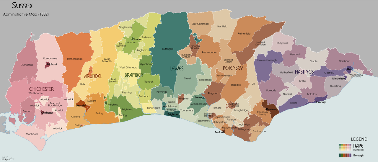
The Arundel Rape covered nearly all of what is now West Sussex until about 1250, when it was split into two rapes the Arundel Rape and the Chichester Rape.[88] In 1834 it contained five hundreds sub-divided into fifty six parishes.[89]
The combined Chichester and Arundel Rape covered nearly all of what is now West Sussex until about 1250, when it was split into two rapes the Arundel Rape and the Chichester Rape.[88] In 1834 it contained seven hundreds and seventy-four parishes.[91]
Medieval sources talk of a group of people who were separate to that of the South Saxons they were known as the Haestingas. The area of Sussex they occupied became the Rape of Hastings.[92]It encompassed the easternmost part of Sussex, with the county of Kent to its east and the Rape of Pevensey to its west. The Anglo-Saxon hundred of Hailesaltede[93] was later partitioned into Battle Hundred and Netherfield Hundred. In 1833, the Rape of Hastings had 13 hundreds giving a total of about 154,060 acres.[94]
The Rape of Lewes is bounded by the Rape of Bramber on its west and the Rape of Pevensey on its east. Although it had the same amount of hundreds in 1833 as in the Domesday survey, there had been some cases of manors and parishes been taken from one and added to another hundred, and in other cases the hundreds had been divided and lost.[95]
Westmorland was divided into four wards, analogous to hundreds. Pairs of wards made up the two Baronies. From Magna Britannica et Hibernia (1736) Genuki: Westmorland, Westmorland
The ancient hundreds in 1086 at the time of the Domesday survey were:[97]Ash, Came,[98] Celfledetorn, Clent, Cresslow, Cutestornes, Doddingtree, Dudstone, Fernecumbe, Fishborough, Greston, Ossulstone, Oswaldslow, Pershore, Plegelgete, Seisdon, Tewkesbury, Tibblestone, Wolfhay.
Some of the parishes within these hundreds, such as Feckenham in Ash Hundred, or Gloucester in Dudstone Hundred, may have partially been in other counties or were transferred between counties in the intervening years.
Over the centuries, some of the hundreds were amalgamated and appear in many useful statistical records. The hundreds that continued their courts until disuse include:
Yorkshire has three Ridings,[104] East, North and West. Each of these was divided into wapentakes, analogous to hundreds.
The Ainsty wapentake, first associated with the West Riding, became associated in the fifteenth century with the City of York, outside the Riding system.
The hundreds of Amounderness and Lonsdale in Lancashire plus part of Westmorland were considered as part of Yorkshire in the Domesday Book.
East Riding
From GENUKI GENUKI: Definitions of the terms used to describe areas of land and habitation in the county of Yorkshire.
Pickering Lythe – Formed from the Domesday wapentake of Dic, and additionally by 1284–85 the parish of Sinnington and by (circa 15th–16th century) the parish of Kirkby Misperton, both from the Domesday wapentake of Maneshou.[107]
Ryedale – First mentioned by name in 1165–66, probably when its court was relocated there. Formed from the Domesday wapentake of Maneshou minus Sinnington and Kirkby Misperton parishes, plus the additional parish of Lastingham from the Domesday wapentake of Dic.[107] In the 19th century, Ryedale contained the parishes of Ampleforth; Appleton-Le-Street; Barton-Le-Street; Great Edston; Gilling; Helmsley; Hovingham; Kirkby Moorside; Kirkdale; Lastingham; New Malton, including the parishes of St. Leonard and St. Michael; Old Malton; Normanby; Nunnington; Oswaldkirk; Salton; Scawton; Slingsby; Stonegrave.[107]
^Genuki – History of Buckinghaham Hundreds Archived 23 August 2009 at the Wayback Machine Retrieved, 21 May 2009
^"Cambridgeshire Hundreds". rootsweb.
^Kelly (1929). Directory of Cambridgeshire, Norfolk & Suffolk.
^"'South Witchford Hundred: Stretham and Thetford', A History of the County of Cambridge and the Isle of Ely: Volume 4: City of Ely; Ely, N. and S. Witchford and Wisbech Hundreds (2002), pp. 151–159". British History Online.
^Lysons, Daniel; Lysons, Samuel (1817). Magna Britannia: Being a Concise Topographical Account of the Several Counties of Great Britain. Containing Darbyshire. Cadell.
^Domesday Map Online: Litchurch
^Craven, Maxwell: Derby Street by Street (Breedon Books, Derby, 2005) ISBN 1-85983-426-4
^"The Hundreds of Devon". GENUKI. Retrieved 20 June 2011.
^"Alvredesberge Hundred was broken up after 1086 and contributed Cranborne, Boveridge, Edmondsham and Pentridge to the later Cranborne Hundred; Brockington to Knowlton Hundred and Wimborne St Giles (see Book of Fees, p. 92; and 10,3 Wimborne note) to the later Wimborne Hundred", quoted from: [1][dead link]
^"Tewkesbury hundred: Upper division | British History Online". www.british-history.ac.uk.
^"The Historical Gazetteer of England's Place-names". Archived from the original on 17 December 2014. Retrieved 28 September 2014.
^Open Domesday: Hampshire. Accessed 22 November 2020.
^Open Domesday: Hampshire folio 9. Accessed 22 November 2020.
^British History Online: King's Somborne Hundred. Accessed 9 October 2022.
^[2] History: the Hundreds.
^"Hundred of Castlery | Domesday Book". opendomesday.org.
^"Hundred of Cutestornes | Domesday Book". opendomesday.org.
^"Hundred of Dinedor | Domesday Book". opendomesday.org.
^"Hundred of Ewias | Domesday Book". opendomesday.org.
^"Hundred of Greytree | Domesday Book". opendomesday.org.
^"Hundred of Hezetre | Domesday Book". opendomesday.org.
^"Hundred of Plegelgete | Domesday Book". opendomesday.org.
^"Hundred of Radlow | Domesday Book". opendomesday.org.
^"Hundred of Stradel | Domesday Book". opendomesday.org.
^"Hundred of Tornelaus | Domesday Book". opendomesday.org.
^Broxash hundred, An Accurate Map of Hereford Shire Divided into its Hundreds, Emanuel Bowen (1755)
^Ewyas-Lacy hundred, An Accurate Map of Hereford Shire Divided into its Hundreds, Emanuel Bowen (1755)
^Greytree hundred, An Accurate Map of Hereford Shire Divided into its Hundreds, Emanuel Bowen (1755)
^Grimsworth hundred, An Accurate Map of Hereford Shire Divided into its Hundreds, Emanuel Bowen (1755)
^Huntington hundred, An Accurate Map of Hereford Shire Divided into its Hundreds, Emanuel Bowen (1755)
^Radlow hundred, An Accurate Map of Hereford Shire Divided into its Hundreds, Emanuel Bowen (1755)
^Stretford hundred, An Accurate Map of Hereford Shire Divided into its Hundreds, Emanuel Bowen (1755)
^Webtree hundred, An Accurate Map of Hereford Shire Divided into its Hundreds, Emanuel Bowen (1755)
^Wigmore hundred, An Accurate Map of Hereford Shire Divided into its Hundreds, Emanuel Bowen (1755)
^Wolphy hundred, An Accurate Map of Hereford Shire Divided into its Hundreds, Emanuel Bowen (1755)
^Wormlow hundred, An Accurate Map of Hereford Shire Divided into its Hundreds, Emanuel Bowen (1755)
^Open Domesday Map: Hertfordshire
^Kent Archaeology: The Cinque Port Liberty of Romney. Archaeologia Cantiana Vol. 13 1880 (p. 261). Accessed 13 February 2022.
^"Leisure & Culture – Lincolnshire County Council". Archived from the original on 27 September 2007. Retrieved 29 November 2005.
^"Hundred of Elloe | Domesday Book". Archived from the original on 8 February 2015. Retrieved 8 February 2015. Open Domesday Map: Elloe Wapentake
^Open Domesday: Gartree (Lincolnshire wapentake)
^"Hundred of Epworth | Domesday Book". Archived from the original on 14 October 2014. Retrieved 27 November 2014.
^"The hundred of Isleworth", A History of the County of Middlesex: Volume 3, (1962), accessed 6 January 2008.
^William White (1845). History, gazetteer, and directory of Norfolk. Published by the author. p. 14.
^Open Domesday: Northamptonshire. Accessed 22 January 2022.
^University of Nottingham: Ordnance Survey – Gravesend Hundred. Accessed 22 January 2022.
^"Hundred map". www.cottinghamhistory.co.uk.
^"About the County". Archived from the original on 16 January 2006. Retrieved 28 November 2005.
^Survey of English Place-Names: Fawsley Hundred. Accessed 22 January 2022.
^[3] Domesday: Guilsborough hundred
^The Penny Cyclopaedia of the Society for the Diffusion of Useful Knowledge: Murilio – Organ. Knight. 1840. p. 320. Retrieved 4 February 2021. "The Penny Cyclopædia of the Society for the Diffusion of Useful Knowledge", Vol. 15–16, page 320.
^"Castle Ward Map". Vision of Britain. Retrieved 4 February 2021.
^A list of the wards, divisions, parishes, and constableries, in the County of Northumberland. J. Graham. 1817. p. 19. Retrieved 4 February 2021.
^Vision of Britain website Archived 12 April 2012 at the Wayback Machine
^Open Domesday: Bampton hundred
^"British History Online: Bampton hundred". British-history.ac.uk. Retrieved 4 February 2021.
^Open Domesday: Binfield hundred
^http://domesdaymap.co.uk/hundred/bloxham/ Archived 14 December 2014 at the Wayback Machine Open Domesday: Bloxham hundred
^http://domesdaymap.co.uk/hundred/benson/ Archived 14 December 2014 at the Wayback Machine Open Domesday: Benson hundred
^http://domesdaymap.co.uk/hundred/kirtlington/ Archived 14 December 2014 at the Wayback Machine Open Domesday: Kirtlington hundred
^http://domesdaymap.co.uk/hundred/lewknor/ Archived 14 December 2014 at the Wayback Machine Open Domesday: Lewknor hundred
^http://domesdaymap.co.uk/hundred/pyrton/ Archived 14 December 2014 at the Wayback Machine Open Domesday: Pyrton hundred
^"British History Online: Ploughley hundred". British-history.ac.uk. Retrieved 4 February 2021.
^"British History Online: Wootten Hundred". British-history.ac.uk. Retrieved 4 February 2021.
^"British History Online: Wootten hundred". British-history.ac.uk. Retrieved 4 February 2021.
^http://domesdaymap.co.uk/hundred/shipton/ Archived 14 December 2014 at the Wayback Machine Open Domesday: Shipton hundred
^http://domesdaymap.co.uk/hundred/wootton/ Archived 28 September 2014 at the Wayback Machine Open Domesday: Wootten hundred
^"British History Online: Wootten hundred (Southern part)". British-history.ac.uk. Retrieved 4 February 2021.
^"BHO: Oxford City Introduction". British-history.ac.uk. Retrieved 4 February 2021.
^"Topographical Dictionary: Oxford". British-history.ac.uk. Retrieved 4 February 2021.
^GENUKI Shropshire hundreds
^"Bradford Hundred | British History Online". www.british-history.ac.uk.
^British History Online The Liberty and Borough of Wenlock
^"Genuki: The Hundreds of Staffordshire, Staffordshire". www.genuki.org.uk.
^William White (1844). History, gazetteer, and directory of Suffolk. p. 15.
^ a b"'The rape of Chichester: Introduction', A History of the County of Sussex: Volume 4 (1953) pp. 1 – 2". Retrieved 28 August 2010.
^Horsfield. History of Sussex. Volume II pp.105–184
^Horsfield. History of Sussex. Volume II pp.185–274
^Horsfield. History of Sussex. Volume II pp.1–104
^Martin Welch. Early Anglo Saxon Sussex in Peter Brandon's. The South Saxons. pp. 33–34
^Open Domesday: Hailesaltede Hundred. Accessed September 2020.
^Horsfield. History of Sussex. Volume II pp.425–592
^Horsfield. History of Sussex. Volume I pp.103–268.
^Horsfield. History of Sussex. Volume I pp.269–424
^Open Domesday Map: Worcestershire
^Survey of English Place Names: Came Hundred, accessed 22 October 2020.
^Open Domesday Map: Halfshire hundred
^"Halfshire hundred". British History. Retrieved 4 February 2021.
^Open Domesday Map: Clent Hundred
^Open Domesday Map: Cresslow Hundred
^ «Сотня Першора: Введение», в «Истории графства Вустер»: том 4, под ред. Уильяма Пейджа и Дж. В. Уиллиса-Бунда (Лондон, 1924), стр. 1–3. British History Online (дата обращения: 22 октября 2020 г.).
^ Room, Adrian (1986). Словарь истинных этимологий . Лондон: Routledge. С. 148–149. ISBN0-415-03060-9.- Слово «езда» происходит от древнескандинавского thrithjung , что означает «третирование» одной трети одинаково важной территории.
^ Уэйпентэйк из Бердфорта. British History Online. Доступ 14 февраля 2024 г.
^ Открыть Domesday: Yarlestre wapentake. Доступ 14 февраля 2024 г.
^ abc "Уэпентейк Райдейл | British History Online". www.british-history.ac.uk .
Заметки о племени Уэпентаке в Линкольншире, из «Введения: потерянные деревни и другие забытые места», Заключительные соглашения графства Линкольн: 1244–1272 (1920), стр. L-LXV


.jpg/1280px-Wenceslas_Hollar_-_Surrey_(State_4).jpg)