43°48′N 22°41′E / 43.800°N 22.683°E / 43.800; 22.683
Vidin Province (Bulgarian: Област Видин) is the northwesternmost province of Bulgaria. It borders Serbia to the west and Romania to the northeast. Its administrative centre is the city of Vidin on the Danube river. The area is divided into 11 municipalities. As of 2023, the province had a population of 72,754.[1]
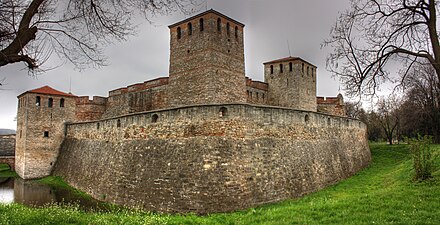
There are remains of many castles, including Baba Vida, one of the last Bulgarian strongholds during the Ottoman invasion and the Belogradchik fortress.
The Vidin Province contains 11 municipalities (singular: община, obshtina - plural: общини, obshtini). The following table shows the names of each municipality in English and Cyrillic, the main town (in bold) or village, and the population of each as of December 2009.

The territory of the province includes the most western parts of the Danubian Plain and Stara Planina, while the Danube forms the border with Romania. The slopes of Stara Planina are covered with dense forests, lush meadows and boasts the majestic rock phenomena, the Belogradchik Rocks. There are around 80 caves situated close to the border with Serbia, the most famous being the Magura Cave, which known with its cave painting from 10,000 BC. There is also a lake in the proximity of the cave.

The Vidin province had a population of 130,074 according to a 2001 census, of which 48.4% were male and 51.6% were female.[8]
As of the end of 2009, the population of the province, announced by the Bulgarian National Statistical Institute, numbered 108,067[2] of which 32.6% are inhabitants aged over 60 years.[9]
Vidin is the oldest province in Bulgaria, with 28.9% of its population 65 years or older at the end of 2016. There is a big difference between the percentage elderly living in urban and rural areas: in urban areas 21.1% of the population is 65 years or older while that percentage is 42.8% in rural areas. The percentage of children up to 15 years is 13.5% in urban areas and only 9.8% in rural areas.
Total population (2011 census): 101 018[10]
Ethnic groups (2011 census):[11]Identified themselves: 95 126 persons:
Religious adherence in the province according to 2001 census:[12]
The place names in bold have the status of town (in Bulgarian: град, transliterated as grad). Other localities have the status of village (in Bulgarian: село, transliterated as selo). The names of localities are transliterated in Latin alphabet[13] followed in parentheses by the original name in Bulgarian Cyrillic alphabet (which links to the corresponding Bulgarian Wikipedia article).
The Belogradchik municipality has one town (in bold) and 17 villages:
- Belogradchik (Белоградчик)
- Borovitsa (Боровица)
- Veshtitsa (Вещица)
- Varba (Върба)
- Granitovo (Гранитово)
- Granichak (Граничак)
- Dabravka (Дъбравка)
- Krachimir (Крачимир)
- Oshane (Ошане)
- Prauzhda (Праужда)
- Prolaznitsa (Пролазница)
- Rabisha (Рабиша)
- Rayanovtsi (Раяновци)
- Salash (Салаш)
- Slivovnik (Сливовник)
- Stakevtsi (Стакевци)
- Struindol (Струиндол)
- Chiflik (Чифлик)
The Boynitsa municipality has 9 villages:
- Boynitsa (Бойница)
- Borilovets (Бориловец)
- Gradskovski kolibi (Градсковски колиби)
- Halovski kolibi (Халовски колиби)
- Kanits (Каниц)
- Perilovets (Периловец)
- Rabrovo (Раброво)
- Shipkova mahala (Шипикова махала)
- Shishentsi (Шишенци)
The Bregovo municipality has one town (in bold) and 9 villages:
- Bregovo (Брегово)
- Baley (Балей)
- Vrav (Връв)
- Gamzovo (Гъмзово)
- Deleyna (Делейна)
- Kalina (Калина)
- Kosovo (Косово)
- Kudelin (Куделин)
- Rakitnitsa (Ракитница)
- Tiyanovtsi (Тияновци)
The Vidin municipality has two towns (in bold) and 33 villages:
- Akatsievo (Акациево)
- Antimovo (Антимово)
- Bela Rada (Бела Рада)
- Botevo (Ботево)
- Bukovets (Буковец)
- Vidin (Видин)
- Voinitsa (Войница)
- Vartop (Въртоп)
- Gaytantsi (Гайтанци)
- General Marinovo (Генерал Мариново)
- Gomotartsi (Гомотарци)
- Gradets (Градец)
- Dinkovitsa (Динковица)
- Dolni Boshnyak (Долни Бошняк)
- Druzhba (Дружба)
- Dunavtsi (Дунавци)
- Zheglitsa (Жеглица)
- Ivanovtsi (Ивановци)
- Inovo (Иново)
- Kalenik (Каленик)
- Kapitanovtsi (Капитановци)
- Koshava (Кошава)
- Kutovo (Кутово)
- Mayor Uzunovo (Майор Узуново)
- Novoseltsi (Новоселци)
- Peshakovo (Пешаково)
- Plakuder (Плакудер)
- Pokrayna (Покрайна)
- Ruptsi (Рупци)
- Tsar Simeonovo (Цар Симеоново)
- Sinagovtsi (Синаговци)
- Slana bara (Слана бара)
- Slanotran (Сланотрън)
- Tarnyane (Търняне)
The Gramada municipality has one town (in bold) and 7 villages:
- Boyanovo (Бояново)
- Brankovtsi (Бранковци)
- Vodna (Водна)
- Gramada (Грамада)
- Medeshevtsi (Медешевци)
- Milchina laka (Милчина лъка)
- Sratsimirovo (Срацимирово)
- Toshevtsi (Тошевци)
The Dimovo municipality has one town (in bold) and 22 villages:
- Archar (Арчар)
- Bela (Бела)
- Vladichentsi (Владиченци)
- Vodnyantsi (Воднянци)
- Varbovchets (Върбовчец)
- Oreshets (Орешец)
- Dimovo (Димово)
- Dalgo pole (Дълго поле)
- Darzhanitsa (Държаница)
- Izvor (Извор)
- Karbintsi (Карбинци)
- Kladorub (Кладоруб)
- Kostichovtsi (Костичовци)
- Lagoshevtsi (Лагошевци)
- Mali Drenovets (Мали Дреновец)
- Medovnitsa (Медовница)
- Gara Oreshets (Гара Орешец)
- Ostrokaptsi (Острокапци)
- Septemvriytsi (Септемврийци)
- Smolya (Скомля)
- Shipot (Шипот)
- Yanyovets (Яньовец)
- Yarlovitsa (Ярловица)
The Kula municipality has one town (in bold) and 8 villages:
- Golemanovo (Големаново)
- Izvor mahala (Извор махала)
- Kosta Perchevo (Коста Перчево)
- Kula (Кула)
- Poletkovtsi (Полетковци)
- Staropatitsa (Старопатица)
- Topolovets (Тополовец)
- Tsar Petrovo (Цар-Петрово)
- Chichil (Чичил)
The Makresh municipality has 7 villages:
The Novo Selo municipality has 5 villages:
- Vinarovo (Винарово)
- Negovanovtsi (Неговановци)
- Novo Selo (Ново село)
- Florentin (Флорентин)
- Yasen (Ясен)
The Ruzhintsi municipality has 10 villages:
The Chuprene municipality has 9 villages: