Западный Техас — неопределённо определённый регион в американском штате Техас , в целом охватывающий засушливые и полузасушливые земли к западу от линии , проведённой между городами Уичито-Фолс , Абилин и Дель-Рио .
Не существует единого мнения о границе между Восточным Техасом и Западным Техасом. [1] Хотя большинство техасцев понимают эти термины, официально границы не признаны, и любые два человека, вероятно, опишут границы этих регионов по-разному. Историк и географ Уолтер Прескотт Уэбб предположил, что 98-й меридиан разделяет Восточный и Западный Техас; [2] писатель А. К. Грин предположил, что Западный Техас простирается к западу от реки Бразос . [3] Однако использование одной линии, по-видимому, исключает использование других разделителей, таких как область — Центральный Техас . Техас является частью американского Юга и американского Юго-Запада одновременно, в то время как полузасушливый и пустынный климат Западного Техаса явно характерен для американского Юго-Запада .
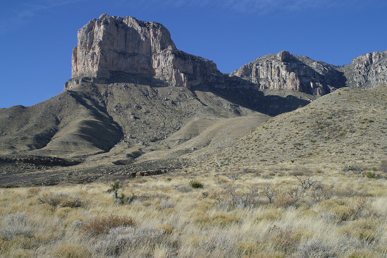
Западный Техас часто подразделяется в соответствии с различными физико-географическими особенностями. Часть Западного Техаса, которая лежит к западу от реки Пекос , часто называют «Дальний Западный Техас» или « Транс-Пекос », термин, введенный в 1887 году геологом Робертом Т. Хиллом . [4] Транс-Пекос находится в пустыне Чиуауа и является самой засушливой частью штата. Другая часть Западного Техаса — Льяно-Эстакадо , обширный регион высоких ровных равнин, простирающийся до восточной части Нью-Мексико и Техасского выступа . К востоку от Льяно-Эстакадо лежит « страна красноземов » Холмистых равнин , а к югу от Льяно-Эстакадо лежит плато Эдвардс . Субрегионы Холмистых равнин и плато Эдвардс действуют как переходные зоны между восточным и западным Техасом.
Западный Техас получает гораздо меньше осадков, чем остальная часть Техаса, и имеет засушливый или полузасушливый климат, требующий, чтобы большая часть его скудного сельского хозяйства в значительной степени зависела от орошения. [5] Северные части области орошаются водой из подземных источников, таких как водоносный горизонт Огаллала . Отбор воды для орошения и забор воды дальше на север для нужд Эль-Пасо и Хуареса, Мексика , превратили Рио-Гранде в ручей в некоторых местах, даже иногда сухой.
В некоторых частях Западного Техаса есть пересеченная местность, включая множество небольших горных хребтов, в то время как большинство частей штата находятся ближе к уровню моря. Северные части Западного Техаса и возвышенности горных хребтов региона Транс-Пекос подвержены случайным сильным снегопадам зимой, тогда как в других районах Западного Техаса снег встречается реже.
.JPG/1280px-Davis_Mts_Nima_(2).JPG)
72 округа Западного Техаса: Эндрюс , Бейли , Борден , Брюстер , Браун , Каллахан , Кастро , Кокран , Коук , Коулман , Команчи , Кончо , Крейн , Крокетт , Кросби , Калберсон , Доусон , Глухой Смит , Диккенс , Истленд , Эктор , Эль-Пасо , Фишер , Флойд , Гейнс , Гарза , Гласскок , Хейл , Хаскелл , Хокли , Ховард , Хадспет , Ирион , Джефф Дэвис , Джонс , Кент , Кимбл , Кинг , Нокс , Лэмб , Лавинг , Лаббок , Линн , Мартин , Мейсон , Маккалок , Менард , Мидленд , Митчелл , Мотли , Нолан , Пекос. , Пресидио , Рейган , Ривз , Раннелс , Шлейхер , Скерри , Шекелфорд , Стивенс , Стерлинг , Стоунволл , Саттон , Тейлор , Террелл , Терри , Трокмортон , Том Грин , Аптон , Уорд , Винклер и Йоакум . [6]
Меньшие города и поселки Западного Техаса включают Алпайн , Эндрюс , Энтони , Браунфилд , Канутильо , Кояноса , Крейн , Фабенс , Форт-Дэвис , Форт-Стоктон , Хейл-центр , Хоризон-Сити , Иран , Кермит , Ламеса , Левелленд , Литтлфилд , Марафон , Марфа , МакКейми , Мертзон , Монаханс , Озона , Пекос , Пост , Ранкин , Рэнсом-Каньон , Сан-Элизарио , Семинол , Слейтон , Снайдер , Суитуотер и Ван-Хорн .
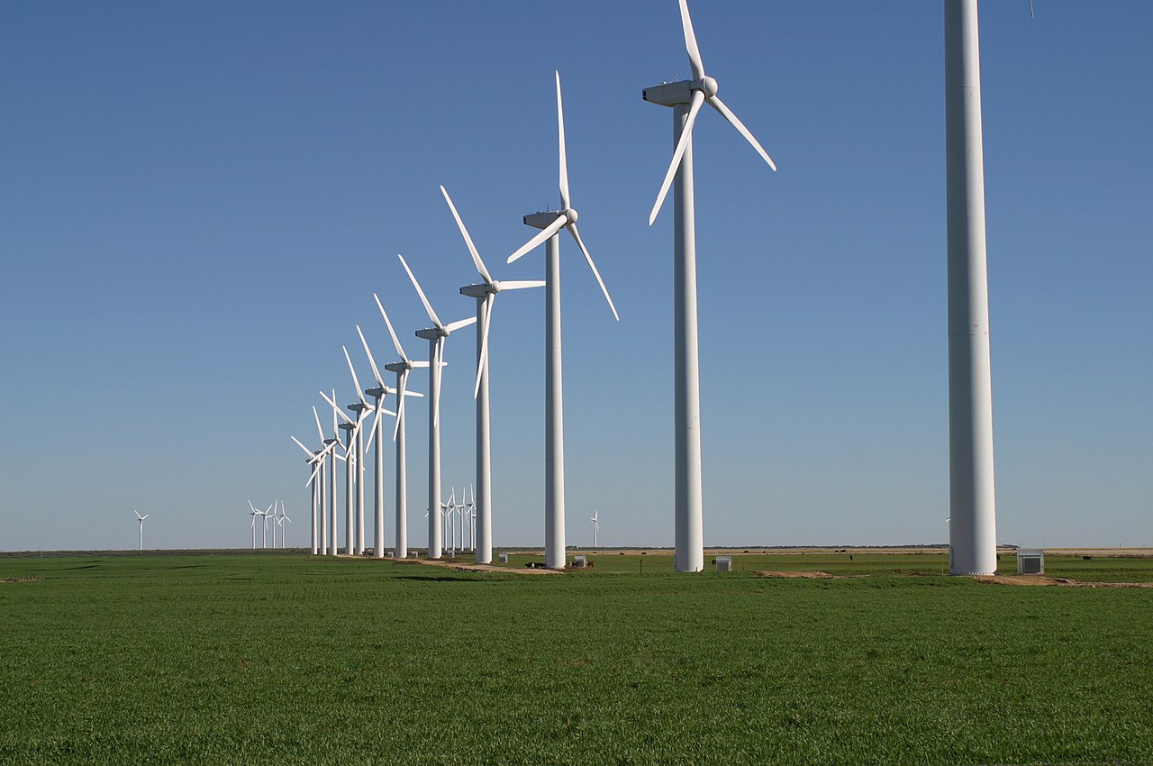
Основные отрасли промышленности включают животноводство , добычу нефти и природного газа , текстильную промышленность, такую как хлопок , зерно , а также из-за очень крупных военных объектов, таких как Форт Блисс , оборонную промышленность . Западный Техас стал известен своими многочисленными ветряными турбинами, производящими чистую и альтернативную электроэнергию .
По состоянию на 2018 год экономика Западного Техаса переживала период процветания , который был описан как «нефтяной бум Западного Техаса». [8] [9]


Хотя в регионе Западного Техаса нет команд высшей лиги, спортивные болельщики верны своим местным школьным и студенческим командам. Команды колледжей дивизиона I NCAA включают Texas Tech Red Raiders и UTEP Miners . Команды дивизиона II NCAA включают West Texas A&M Buffaloes , Texas–Permian Basin Falcons , а также Lubbock Christian Chaparrals и Lady Chaps .
В Эль-Пасо базируются El Paso Chihuahuas , бейсбольная команда AAA, и El Paso Locomotive FC , играющая в USL Championship , втором уровне американской футбольной пирамиды . Midland RockHounds и Amarillo Sod Poodles представляют регион в бейсболе double-A. В регионе также представлен юниорский хоккей с командой Odessa Jackalopes из Североамериканской хоккейной лиги второго уровня.

За исключением региона Транс-Пекос, Западный Техас стал хорошо известен как оплот консервативной политики. Некоторые из наиболее республиканских округов в Соединенных Штатах находятся в этом регионе. Бывший президент США Джордж Буш-младший провел большую часть своего детства в Западном Техасе. [10]
Регион включает в себя большую часть Пермского бассейна , самого производительного нефтяного месторождения в Соединенных Штатах. [11] Это, вероятно, склоняет регион к поддержке Республиканской партии, а не Демократической партии , поскольку последняя поддерживает экологию и действия по борьбе с изменением климата . [12] [13]
Несколько округов в районе Мидленд-Одесса были одними из первых частей Техаса, которые отказались от демократических корней штата « Solid South » ; два округа [a] не поддерживали демократов на пост президента с 1948 года . Холмистые равнины на востоке оставались демократическими значительно дольше: хотя кампания Уолтера Мондейла 1984 года потеряла Техас на 27,50%, он выиграл три округа в этом регионе. [b] С 2000 года этот регион очень быстро качнулся в сторону Республиканской партии из-за непримиримой оппозиции его населения либеральной социальной политике Демократической партии, [14] и к 2016 году он имел почти такой же PVI Кука, как и Панхэндл.
«К западу от Пекоса» стало метафорой для вселенной вестернов . «Самый быстрый розыгрыш к западу от Пекоса» и подобные превосходные степени являются клише, а главный герой Чисума заметил: «Нет закона к западу от Доджа, и нет Бога к западу от Пекоса».
Действие романа Кормака Маккарти «Старикам тут не место» и его последующей экранизации происходит в Западном Техасе, и большая часть фильма была снята там.
Несмотря на то, насколько велики города и насколько они демократичны, техасские демократы все еще не могут преодолеть красную стену сельского Западного Техаса, сказал [Дрю Лэндри]. Сельский Техас по-прежнему правит бал. Я видел очень, очень близкие цифры до того, как многие сельские округа сообщили [результаты выборов], и как только они это сделали, это просто распахнуло дверь для Эбботта.