An estuary is a partially enclosed coastal body of brackish water with one or more rivers or streams flowing into it, and with a free connection to the open sea.[1] Estuaries form a transition zone between river environments and maritime environments and are an example of an ecotone. Estuaries are subject both to marine influences such as tides, waves, and the influx of saline water, and to fluvial influences such as flows of freshwater and sediment. The mixing of seawater and freshwater provides high levels of nutrients both in the water column and in sediment, making estuaries among the most productive natural habitats in the world.[2]
Most existing estuaries formed during the Holocene epoch with the flooding of river-eroded or glacially scoured valleys when the sea level began to rise about 10,000–12,000 years ago.[3] Estuaries are typically classified according to their geomorphological features or to water-circulation patterns. They can have many different names, such as bays, harbors, lagoons, inlets, or sounds, although some of these water bodies do not strictly meet the above definition of an estuary and could be fully saline.
Many estuaries suffer degeneration from a variety of factors including soil erosion, deforestation, overgrazing, overfishing and the filling of wetlands. Eutrophication may lead to excessive nutrients from sewage and animal wastes; pollutants including heavy metals, polychlorinated biphenyls, radionuclides and hydrocarbons from sewage inputs; and diking or damming for flood control or water diversion.[3][4]


The word "estuary" is derived from the Latin word aestuarium meaning tidal inlet of the sea, which in itself is derived from the term aestus, meaning tide. There have been many definitions proposed to describe an estuary. The most widely accepted definition is: "a semi-enclosed coastal body of water, which has a free connection with the open sea, and within which seawater is measurably diluted with freshwater derived from land drainage".[1] However, this definition excludes a number of coastal water bodies such as coastal lagoons and brackish seas.
A more comprehensive definition of an estuary is "a semi-enclosed body of water connected to the sea as far as the tidal limit or the salt intrusion limit and receiving freshwater runoff; however the freshwater inflow may not be perennial, the connection to the sea may be closed for part of the year and tidal influence may be negligible".[3] This broad definition also includes fjords, lagoons, river mouths, and tidal creeks. An estuary is a dynamic ecosystem having a connection to the open sea through which the sea water enters with the rhythm of the tides. The effects of tides on estuaries can show nonlinear effects on the movement of water which can have important impacts on the ecosystem and waterflow. The seawater entering the estuary is diluted by the fresh water flowing from rivers and streams. The pattern of dilution varies between different estuaries and depends on the volume of freshwater, the tidal range, and the extent of evaporation of the water in the estuary.[2]
Drowned river valleys are also known as coastal plain estuaries. In places where the sea level is rising relative to the land, sea water progressively penetrates into river valleys and the topography of the estuary remains similar to that of a river valley. This is the most common type of estuary in temperate climates. Well-studied estuaries include the Severn Estuary in the United Kingdom and the Ems Dollard along the Dutch-German border.
The width-to-depth ratio of these estuaries is typically large, appearing wedge-shaped (in cross-section) in the inner part and broadening and deepening seaward. Water depths rarely exceed 30 m (100 ft). Examples of this type of estuary in the U.S. are the Hudson River, Chesapeake Bay, and Delaware Bay along the Mid-Atlantic coast, and Galveston Bay and Tampa Bay along the Gulf Coast.[5]
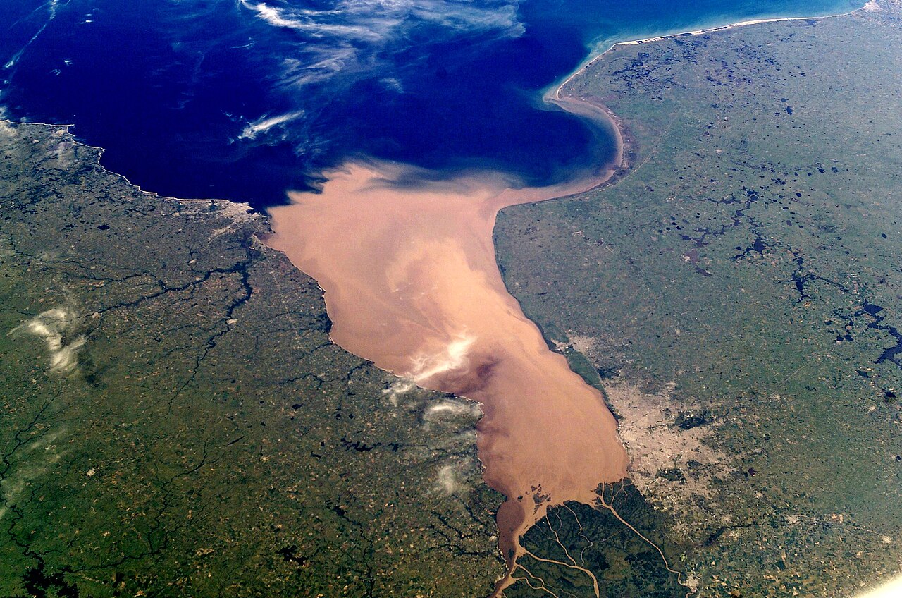
Bar-built estuaries are found in a place where the deposition of sediment has kept pace with rising sea levels so that the estuaries are shallow and separated from the sea by sand spits or barrier islands. They are relatively common in tropical and subtropical locations.
These estuaries are semi-isolated from ocean waters by barrier beaches (barrier islands and barrier spits). Formation of barrier beaches partially encloses the estuary, with only narrow inlets allowing contact with the ocean waters. Bar-built estuaries typically develop on gently sloping plains located along tectonically stable edges of continents and marginal sea coasts. They are extensive along the Atlantic and Gulf coasts of the U.S. in areas with active coastal deposition of sediments and where tidal ranges are less than 4 m (13 ft). The barrier beaches that enclose bar-built estuaries have been developed in several ways:
Fjords were formed where Pleistocene glaciers deepened and widened existing river valleys so that they become U-shaped in cross-sections. At their mouths there are typically rocks, bars or sills of glacial deposits, which have the effects of modifying the estuarine circulation.
Fjord-type estuaries are formed in deeply eroded valleys formed by glaciers. These U-shaped estuaries typically have steep sides, rock bottoms, and underwater sills contoured by glacial movement. The estuary is shallowest at its mouth, where terminal glacial moraines or rock bars form sills that restrict water flow. In the upper reaches of the estuary, the depth can exceed 300 m (1,000 ft). The width-to-depth ratio is generally small. In estuaries with very shallow sills, tidal oscillations only affect the water down to the depth of the sill, and the waters deeper than that may remain stagnant for a very long time, so there is only an occasional exchange of the deep water of the estuary with the ocean. If the sill depth is deep, water circulation is less restricted, and there is a slow but steady exchange of water between the estuary and the ocean. Fjord-type estuaries can be found along the coasts of Alaska, the Puget Sound region of western Washington state, British Columbia, eastern Canada, Greenland, Iceland, New Zealand, and Norway.
These estuaries are formed by subsidence or land cut off from the ocean by land movement associated with faulting, volcanoes, and landslides. Inundation from eustatic sea-level rise during the Holocene Epoch has also contributed to the formation of these estuaries. There are only a small number of tectonically produced estuaries; one example is the San Francisco Bay, which was formed by the crustal movements of the San Andreas Fault system causing the inundation of the lower reaches of the Sacramento and San Joaquin rivers.[6]
In this type of estuary, river output greatly exceeds marine input and tidal effects have minor importance. Freshwater floats on top of the seawater in a layer that gradually thins as it moves seaward. The denser seawater moves landward along the bottom of the estuary, forming a wedge-shaped layer that is thinner as it approaches land. As a velocity difference develops between the two layers, shear forces generate internal waves at the interface, mixing the seawater upward with the freshwater. An examples of a salt wedge estuary is Mississippi River[6] and the Mandovi estuary in Goa during the monsoon period.
As tidal forcing increases, river output becomes less than the marine input. Here, current induced turbulence causes mixing of the whole water column such that salinity varies more longitudinally rather than vertically, leading to a moderately stratified condition. Examples include the Chesapeake Bay and Narragansett Bay.[6]
Tidal mixing forces exceed river output, resulting in a well-mixed water column and the disappearance of the vertical salinity gradient. The freshwater-seawater boundary is eliminated due to the intense turbulent mixing and eddy effects. The lower reaches of Delaware Bay and the Raritan River in New Jersey are examples of vertically homogeneous estuaries.[6]
Inverse estuaries occur in dry climates where evaporation greatly exceeds the inflow of freshwater. A salinity maximum zone is formed, and both riverine and oceanic water flow close to the surface towards this zone.[7] This water is pushed downward and spreads along the bottom in both the seaward and landward direction.[3] Examples of an inverse estuary are Spencer Gulf, South Australia,[8] Saloum River and Casamance River, Senegal.[9]
Estuary type varies dramatically depending on freshwater input, and is capable of changing from a wholly marine embayment to any of the other estuary types.[10][11]
The most important variable characteristics of estuary water are the concentration of dissolved oxygen, salinity and sediment load. There is extreme spatial variability in salinity, with a range of near-zero at the tidal limit of tributary rivers to 3.4% at the estuary mouth. At any one point, the salinity will vary considerably over time and seasons, making it a harsh environment for organisms. Sediment often settles in intertidal mudflats which are extremely difficult to colonize. No points of attachment exist for algae, so vegetation based habitat is not established.[clarification needed] Sediment can also clog feeding and respiratory structures of species, and special adaptations exist within mudflat species to cope with this problem. Lastly, dissolved oxygen variation can cause problems for life forms. Nutrient-rich sediment from human-made sources can promote primary production life cycles, perhaps leading to eventual decay removing the dissolved oxygen from the water; thus hypoxic or anoxic zones can develop.[12]

Nitrogen is often the lead cause of eutrophication in estuaries in temperate zones.[13] During a eutrophication event, biogeochemical feedback decreases the amount of available silica.[14] These feedbacks also increase the supply of nitrogen and phosphorus, creating conditions where harmful algal blooms can persist. Given the now off-balance nitrogen cycle, estuaries can be driven to phosphorus limitation instead of nitrogen limitation. Estuaries can be severely impacted by an unbalanced phosphorus cycle, as phosphorus interacts with nitrogen and silica availability.
With an abundance of nutrients in the ecosystem, plants and algae overgrow and eventually decompose, which produce a significant amount of carbon dioxide.[15] While releasing CO2 into the water and atmosphere, these organisms are also intaking all or nearly all of the available oxygen creating a hypoxic environment and unbalanced oxygen cycle.[16] The excess carbon in the form of CO2 can lead to low pH levels and ocean acidification, which is more harmful for vulnerable coastal regions like estuaries.

Eutrophication has been seen to negatively impact many plant communities in estuarine ecosystems.[17] Salt marshes are a type of ecosystem in some estuaries that have been negatively impacted by eutrophication.[17] Cordgrass vegetation dominates the salt marsh landscape.[18] Excess nutrients allow the plants to grow at greater rates in above ground biomass, however less energy is allocated to the roots since nutrients is abundant.[17][19] This leads to a lower biomass in the vegetation below ground which destabilizes the banks of the marsh causing increased rates of erosion.[17] A similar phenomenon occurs in mangrove swamps, which are another potential ecosystem in estuaries.[19][20] An increase in nitrogen causes an increase in shoot growth and a decrease in root growth.[19] Weaker root systems cause a mangrove tree to be less resilient in seasons of drought, which can lead to the death of the mangrove.[19] This shift in above ground and below ground biomass caused by eutrophication could hindered plant success in these ecosystems.[17][19]