Большой перевал Сен-Бернар ( французский : Col du Grand St-Bernard , итальянский : Colle del Gran San Bernardo , немецкий : Grosser Sankt Bernhard ; ретороманский : Pass del Grond Son Bernard ) — третий по высоте перевал в Швейцарии , расположенный на высоте 2469 м (8100 футов). Он соединяет Мартиньи в кантоне Вале в Швейцарии с Аостой в регионе Валле-д'Аоста в Италии . Это самый низкий перевал, лежащий на хребте между двумя самыми высокими горами Альп , Монбланом и Монте -Розой . Он расположен на главном водоразделе , отделяющем бассейны Роны и По . [2]
Большой Сен-Бернар – один из самых древних перевалов через Западные Альпы , свидетельства которого использовались еще в бронзовом веке , и сохранились следы римской дороги . В 1800 году армия Наполеона использовала перевал, чтобы войти в Италию, это событие изображено в картинах Жака-Луи Давида « Наполеон на перевале Сен-Бернар» и « Бонапарт, пересекающий Альпы » Поля Делароша , обе известные картины маслом. Поскольку его обходили более простыми и практичными маршрутами, в частности туннелем Большой Сен-Бернар , автодорожным туннелем, который открылся в 1964 году, его сегодняшняя ценность в основном историческая и рекреационная.
Хоспис Великого Сенбернара , расположенный на самой высокой точке дороги, был основан в 1049 году. Позже хоспис прославился тем, что использовал собак Сенбернара в спасательных операциях. Итальянская часть района также включает в себя несколько объектов. Между ними находится небольшое озеро Большого Сен-Бернара .
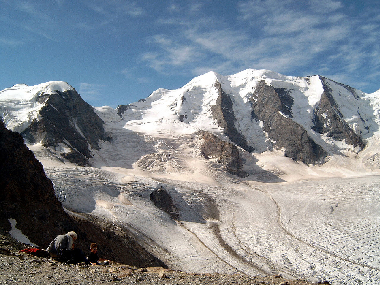
Перевал Большой Сен-Бернар расположен недалеко от западной оконечности Альп Вале , следующий перевал на западе, Коль Ферре , отмечает переход с массивом Монблан . В этом районе, между Мон-Долентом и Мон-Веланом , главный гребень Альп едва достигает высоты 3000 метров, в отличие от гораздо более высокого участка Альп Вале к востоку от Мон-Велана и Гран-Комбена . Таким образом, перевал Большой Сен-Бернар является одной из двух дорог, соединяющих Вале с северной Италией, а другой осью является перевал Симплон . [3]
Перевал проходит с северо-запада на юго-восток через Альпы Вале (ранее известные как Пеннинские Альпы в честь римского названия перевала, poeninus mons или summus poeninus ) на максимальной высоте 2469 м (8100 футов). Дорога, проходящая через перевал, шоссе E27 в Италии и Швейцарии , соединяет Мартиньи на верхней Роне в кантоне Вале , Швейцария, с Аостой в регионе Валле-д'Аоста в Италии. От Мартиньи маршрут 9 спускается в Лозанну , а от Аосты маршрут А5 спускается в Турин .

С севера, в Швейцарии, путь к перевалу проходит по нижней части реки Дранс выше Мартиньи, затем в малонаселенную Валь д'Энтремон (букв.: «долина между горами»), через которую протекает Дранс д'Энтремон. . Миновав последний населенный пункт Бур-Сен-Пьер , дорога проходит над большим водохранилищем Лак-де-Тул . В районе Бур-Сен-Бернар туннель Большой Сен-Бернар (и главная дорога) проходит сквозь горы на высоте 1915 м (6283 фута), что с момента открытия туннеля в 1964 году снижает коммерческую значимость дороги. над перевалом. Вершинный участок дороги состоит из крутых поворотов, прежде чем он достигнет вершины перевала после прохождения Комб-де-Морт.
На южной стороне маршрут спускается на несколько метров и достигает берегов озера, прежде чем оно войдет в Италию. Далее маршрут следует по крутым склонам верхней части потока Гранд-Сен-Бернар на юг, затем поворачивает на восток и следует по излучине реки на юг, где горная река впадает в поток Артанаваз возле Сен-Бернара. Реми-ан-Босс и снова поворачивает на восток, затем плавно на юго-восток в Ла-Клюза ( Жиньо ). Здесь река впадает в реку Бутье в нижнем конце долины Вальпеллин и снова поворачивает на юг, где, наконец, река впадает в Дора Балтеа возле Пон-де-Пьер в Аосте . Маршрут здесь, в главной долине Валь д'Аост, становится частью автомагистрали А5 , соединяющей туннель Монблан на западе и верхнюю часть бассейна реки По на юго-востоке.
Снижение полезности началось после строительства туннеля Симплон , строго железнодорожного туннеля, в 100 км (62 мили) к востоку в 1905 году. граница с Италией проходима только с июня по сентябрь.
Перевал в самом узком месте проходит между вершинами Гранд-Шеналетт на высоте 2889 м (9478 футов) и Мон-Морт на высоте 2867 м (9406 футов). Чуть западнее находится самая высокая вершина Пуэнт-де-Дрон на высоте 2949 м (9675 футов). Между ним и перевалом находится Петит Шеналетт на высоте 2885 м (9465 футов). [4]
Тур де Франс посетил перевал пять раз. На него было пройдено четыре раза в категории 1-й категории и один раз, в 2009 году, в категории для внеклассных восхождений. [5]
Зимой глубина снега на перевале может достигать 10 метров. Температура может упасть до -30°C. Озеро на перевале замерзает 265 дней в году. [6] Ниже приведены сводные данные о погоде за 1991-2020 годы.
The pass is well above the tree line. All the wood required for construction and firewood must be hauled in from some distance. On the south-west side of the pass is a small tarn, the Great St Bernard Lake, which captures melt water and does not support fish, even though attempts have been made to stock it. In past years the tarn has not always thawed completely in summer.
Alpine flowers are abundant in the vicinity: Gentiana clusii, Ranunculus glacialis, Dryas octopetala, Forget-me-not, Saxifraga oppositifolia among many hundreds more. Moss is prolific and the rocks are lichen-covered.[8]: 9

A hospice for travellers was founded in 1049 by Saint Bernard of Menthon and came to be named after him in the 16th century, along with the pass. It was not the first hospice in the pass. Buildings were probably there since the Roman times, but the region was not secure and they were destroyed many times. The first concern of the founder of the current monastery was to clear the region of bandits and keep the pass safe for travellers, the role of rescuers developing naturally. The hospice later became famous for its use of St Bernard dogs in rescue operations. Pope Pius XI confirmed Bernard as patron saint of the Alps in 1923.
The hospice straddles the highest point of the road, which is in Switzerland. Today the modern road for through traffic has been routed around the outside of the monastery buildings to allow some integrity of the grounds. The old road may still be seen, above the paved road. The hospice occupies two buildings, of 1560 and 1898 (picture, above). The Congregation of Canons of the Great Saint Bernard (the monks) also owns the Hôtel de l'Hospice du Grand-St-Bernard, a four-storey building made of grey stone (built in 1899) on the Italian side, which it leases to a private entrepreneur for the provision of hotel services.[9]
The St Bernards were bred large enough to traverse deep snow and to find lost persons by scent. The first evidence that the dogs were in use at the monastery is two paintings dating to 1690 by Salvator Rosa. It is often said that they carried small casks of brandy around their necks (although this is only legend), in the belief that the liquor had medicinal properties.

A description of an overnight stay at the monastery in 1857 was given by Theodore Nielsen, a Danish kleinsmith journeyman, in his memoirs:
"In the evening we reached the monastery of St Bernard on the top of the mountain. Enormous sums of money were expended to build these cloisters that were made of stonework and were placed there to give sustenance to travellers on the Alps between Italy and Switzerland. We came into a large hall where several other wanderers were seated. The monks came to shake hands with us and bid us welcome. A doctor – also a monk – asked if we had suffered any mishap coming up. The ones that had gotten hurt were treated and taken care of. They had an apothecary there also to administer to any one needing such. Another monk gave us a bowl with hot bouillon mixed with wine to warm us. We sat on wooden benches and talked with the rest of the people. There was a large stove and the place was lovely and warm. Some of the large St Bernard dogs were about and when we sat down came over to give our hands a lick just as if they wanted to say Hello too. At dinnertime we were given a piece of meat on a wooden trivet, bread and wine. The bread was so hard that it seemed we tried to bite into a piece of wood. Later we were shown into a room with good beds already made up. As we came from the warmth of the hall into the cold room we started to shiver and just couldn't get warm, so we didn't get much sleep. My turtle was cold, too, so I took it to bed with me to try to warm it a bit. We arose at five the next morning and were given a very good and generous breakfast before we started our descent of the mountain. The clouds were threatening, black and so heavy that we could see nothing and wished earnestly that we were back onto the green earth once more. It was hard work going up the mountain but worse going down. We sank into the snow, several times so deep that we had all we could do to get up again. I had expected to see some of the dogs, but we were following the wooden markers and the dogs are trained to go afield and search for the ones that missed the markers. It is impossible to find the way over the mountain without help. The large dogs searched in pairs - one has a wooden keg fastened under his chin. When they locate a victim he is offered the wine to keep him alive while the other dog runs back to the monastery to lead the monks who transport the lost back. Sometimes the lost are no longer alive."[10]
Today the tunnel and modern technology have made rescue operations at the pass mainly unnecessary. The dogs were put up for sale in 2004 because of the high cost of maintenance and were promptly bought by two foundations created for the purpose: Fondation Barry du Grand Saint Bernard[11] (major contributor Christine Cerletti-Sarasin) and Fondation Bernard et Caroline de Watteville.[12][13] Barry bought the kennels and the facilities in Martigny and continues to support and breed the dogs (three or four dozen). One condition of the sale is that they be brought to the monastery for the summer. Travellers are likely to see them romping around the slopes.[14][15] The de Watteville Foundation keeps several dogs in kennels adjunct to its Musée. Both have agreed to work together and others have joined the partnership.[16]
The monastery currently houses a handful of monks on a permanent basis, and serves as a spiritual centre for others on retreat.

.jpg/1280px-Grand_St_Bernard_(top).jpg)
The pass first appears in history as the route taken by the Celtic tribes of the Boii and Lingones in the invasion of Italy of 390 BC.[17] The classical authors first mentioning the pass in that or other contexts lived the 1st century BC under the early Roman empire. They were calling the pass and the mountains Poeninus or Poenini, "Punic", an apparent reference to Hannibal's crossing. He did not cross there, however. On the presumption that the name was falsely altered by analogy, it can be reconstructed to *peninus, a Roman-Celtic word, considering that Celtic tribes owned the entire pass until defeated by the Romans.[18] Livy says that the pass was not named after the Carthaginians but after a mountain god.[19] For well over a century scholars such as the Grimm brothers have made a connection with continental Celtic pen or ben, "head, summit, chief" on an analogy with the Zeus karaios of Hesychius.[20]
Two tribes occupied the valleys on either side of the pass on a permanent basis: the Veragri on the Swiss side and the Salassi on the Italian side.
Julius Caesar sent an expedition under his best commander, Servius Galba, from Gaul in 57 BC to seize the pass, hoping to obtain a shorter route between Italy and Gaul than the contemporaneous coastal route. Galba was deceived by the Veragri into making camp near Martigny with the expectation of moving into the pass on the next day. At that time the Romans found the heights over the trail occupied by three hostile Gallic tribes. The Romans won a local victory by a daring foray from the camp but Galba judged he could not take the pass and departed.
Augustus succeeded where his adoptive father failed and the pass became Roman. Augustus placed a large castra stativa and colony, Augusta Praetoria Salassorum, below the pass, which became Aosta (contraction of Augusta). Its ruins are a historic attraction there. By 43 AD under the emperor Claudius a good Roman road through the pass was completed with a mansio at the top and a temple to Jupiter Poeninus, resulting in the name Mons Jovis in late antiquity, Monte Jove in the early Italian period and Mont Joux in the French period, a synonym for the pass.[6] The site of the temple is known as the Plan de Jupiter, located on a knoll on the Italian side of the pass. A cross was placed there in 1816 bearing the inscription Deo optimo maximo, "to the best and greatest god." The bronze statue of St Bernard on a pedestal above the road on the Italian side, across a small valley from the cross, was constructed in 1905 on the site of the Roman mansio.
The coins and votive tablets found at the site of the temple roughly date the upper limit of Roman control of the pass. The youngest date to the reign of Theodosius II (1st half of the 5th century). These and other artifacts are stored in the monastery museum.[8]: 11 Fragments of the marble temple, some with inscriptions, have been incorporated into many structures of the village of Bourg-Saint-Pierre on the Swiss side of the pass. The Roman milestone for mile XXIIII was also brought to the center of the settlement from the top of the pass.[21]

The pass had entered history with the Gallic invasion of 390 BC. The last Gallic invasion over it occurred in May, 1800, under the direction of the 30-year-old First Consul of the French Republic, Napoleon Bonaparte. An Austrian army of 140,000 men had laid siege to French-occupied Genoa on the west coast of northern Italy. Napoleon traversed the pass with 40,000 men and ⅓ of their heavy artillery, sending another 20,000 over three other passes as a diversion, intending to strike the Austrian rear. The panicked Austrians were unable to assemble fast enough to meet the French en masse but rather in a piecemeal way in June 1800, and so were defeated first at the Battle of Montebello and then at the Battle of Marengo.
Napoleon prepared for the march secretly by assembling men in small units below the pass, establishing supply dumps along the lower part of their route, and hiring artisans to set up shop along it as well. On May 15 an advance unit went over the pass to take Aosta, after which hospitals were set up at Martigny and Aosta. At Martigny the army assembled and received rations for three days. All the equipment - carriages, artillery, arms and ammunition - was disassembled and divided into packs of 60-70 pounds for the men to carry. The cannons were to be dragged up over the snow in hollowed-out pine half-logs by mules, and then when the mules died or were exhausted, by 100 soldiers and hired men each. Napoleon offered liberal monetary rewards to soldiers and laborers who could perform difficult portages in a timely fashion.

Over several days at the end of May the army went over the pass single-file, 6000 men per day. Bands played martial music along the route, with drum rolls at especially difficult places to alert the men. At the top the monks handed each man two glasses of wine and a slice of rye with cheese as he filed by (courtesy of the French army). Accounts of the amounts expended vary. On the other side the snow became so packed that the men slid down sitting. Napoleon was the last man over, sliding also. The good weather held for the entire crossing, otherwise the crossing could have easily become disasterous.
On the way up Napoleon had discussed affairs of the heart with his young guide and mule driver, Pierre Nicholas Dorsaz, who did not know his identity. Offered a reward at the top, Dorsaz asked for the mule on which Napoleon was riding. He received the mule and a short note for the chief supply officer of the army. Versions of the story vary, but they all agree that when the young man had turned in the note and had drawn his ample pay for the work, he found that his companion was Napoleon and the latter had given him a house and farm so that he could marry his sweetheart.
In the Aosta Valley Napoleon's army slipped by an Austrian garrison at Bard just out of cannon range. The commander related that he was astonished to watch an army of 40,000 men in full equipment go marching past from the direction of the heights.[22][23]
The Dorrit family crossed from France into Italy in Book Two: Riches of the novel Little Dorrit by Charles Dickens. They meet the newly-wed Gowans and the gentlemanly murderer Rigaud, now called Blandois, at the inn after climbing up on mules. The novel was published in 1857, but set in the mid 1820s. Dickens describes the sites of the pass, and the experience of staying overnight in the inn, having visited it in person.