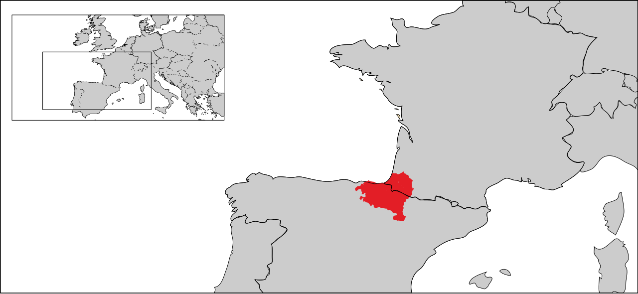


The French Basque Country (French: Pays basque français; Spanish: País Vasco francés), or Northern Basque Country (Basque: Ipar Euskal Herria, or Iparralde, lit. 'the Northern Region'), is a region lying on the west of the French department of the Pyrénées-Atlantiques. Since 1 January 2017, it constitutes the Basque Municipal Community (Basque: Euskal Hirigune Elkargoa; French: Communauté d'Agglomeration du Pays Basque) presided over by Jean-René Etchegaray.[1][2]
It includes three former historic French provinces in the north-east of the traditional Basque Country totalling 2,967 km2 (1,146 sq mi): Lower Navarre (French: Basse-Navarre; Basque: Nafarroa Beherea), until 1789 nominally Kingdom of Navarre, with 1,284 km2 (496 sq mi); Labourd (Lapurdi), with 800 km2 (310 sq mi); Soule (Zuberoa), with 785 km2 (303 sq mi). The population included in the Basque Municipal Community amounts to 309,723 inhabitants distributed in 158 municipalities.[3]
It is delimited in the north by the department of Landes, in the west by the Bay of Biscay, in the south by the Southern Basque Country and in the east by Béarn (although in the Béarnese village of Esquiule, Basque is spoken), which is the eastern part of the department. Bayonne and Biarritz (BAB) are its chief towns, included in the Basque Eurocity Bayonne-San Sebastián Euroregion.[4] It is a popular tourist destination and is somewhat distinct from neighbouring parts of the southern Basque Country, since it was not industrialized as Biscay or Gipuzkoa and remained agricultural and a beach destination.
The department of the Pyrénées-Atlantiques is divided into three districts or arrondissements: The Arrondissement of Bayonne, the Arrondissement of Oloron-Sainte-Marie, and the Arrondissement of Pau. French Basque Country includes all of Bayonne and Canton of Montagne Basque in Oloron-Sainte-Marie. Additionally, it includes the following territories in Béarn: Esquiule, Aramits, Géronce, and Arette (in the Canton of Oloron-Sainte-Marie-1).
The French Basque Country included three pre-existing historic territories before the departmental division of France in 1789, with a few modifications:
The most important city in the territory is Bayonne (French: Bayonne, in Gascon and Basque: Baiona). The ancient Roman Lapurdum, from which the toponyms Labourd and Lapurdi originate, is a part of the Biarritz-Anglet-Bayonne agglomeration community (BAB) alongside Biarritz and Anglet (Basque: Angelu), the most populated urban space in the territory. It is the political capital of its subprefecture and economic capital of the largest region, which includes the French Basque country and the south of Landes. Other important places are Saint-Jean-de-Luz (Basque: Donibane Lohizune), Hendaye (Hendaia), Saint-Jean-Pied-de-Port (Donibane Garazi), the capital of Lower Navarre, and Mauleón (Maule), the capital of Soule.
A slow but continuous French institutional evolution has been produced as a response to the historical claims of the French Basque Country. By an order from 29 January 1997 from the prefect of the Pyrénées-Atlantiques, a "Basque Country" was recognized as a pays, according to the French administrative category,[5] in accordance with the laws called: the Pasqua Law (LOADT)[6] from 4 February 1995, and the Voynet Law (LOADDT)[7] from 25 June 1999. These are based on the notion of a country in the traditional sense, as a society belonging to a place, culture, etc., promoting the organization and development of the territory in a global manner.
The creation of an institution of greater substance than what was represented by the geographical organization of pays and more specifically of a Basque department, has been a constant element during that last decades in elected posts for the main political parties, with representation from the French Socialist Party, The Republicans, and nationalist parties.[8] 64% of Basque-French mayors[9] support such a creation. The Association des Élus[10] is an association that groups political posts such as regional councilors, general councilors and mayors of the French Basque Country, from both political spectrums, whose goal is to achieve the division of the Pyrénées-Atlantiques department into Basque and Béarnese departments respectively (24 of the existing mainland departments have smaller populations than the French Basque Country).
The Council of the Development of the French Basque Country was created in 1994, and in 1995 the Council of the Elected of the French Basque Country (Association des Élus du Pays Basque) was created.
On 15 January 2005, the Euskal Herriko Laborantza Ganbara (Chamber of Agriculture for the Basque Country),[11] was created as a house for the representation and promotion of the interests of livestock farmers and agriculturists of the French Basque Country, promoted by the agrarian union, Laborarien Batasuna. Initially, this institution wasn't recognised, and its function was illegal. Now, its function is regulated and receives subventions from the Regional Council of Aquitaine.
In 2012, the French government proposed the creation of a single commonwealth for all of the towns in French Basque Country, under two conditions: being approved by at least half of the 158 communes in the historic territory, and that at least half of the nearly 300,000 residents be represented within this historic territory. After a process of municipal meetings, on 2 May 2016, both conditions were met.[12]
On 1 January 2017, the Agglomerate Community of Basque Country,[13][14] was created: an intercommunal cooperation movement (EPCI), which promotes a greater level of autonomy, with the French administrative categorization as an official territorial administrative structure with greater abilities than a pays, but fewer than a French department, and that is made up of a union of ten commonwealths and 157 of the 159 Basque communes, plus one Béarnese community.


The oldest human remains that are known of in the territory of the current French Basque Country are approximately 150,000 years old. Some houses have been found on the terraces of the river Adour, in Ilbarritz (Bidart), Saint-Pierre-d'Irube and Mouguerre. In the Middle Paleolithic era (700,000–100,000 years BP), Neanderthals inhabited this area. At the beginning they lived in the open air and later in caves, like the one in Isturits. Cro-magnon people appeared during the Upper Paleolithic (9,000–50,000 years BP).
Many artistic objects from the Magdalenian era (9,000–14,000 years BP) have been found in Isturits.
The most well-known object found is a bird bone with three holes in it in the shape of a txistu. Moving into the Mesolithic era, humans began to live outside of caves, despite the fact that these were still used until a much later date. Also, during this era, the artefacts of ceramics, agriculture, and raising livestock were discovered.
During the Neolithic era (4000–3000 B.C.E.), new techniques for the use of metals and agriculture arrived.
The present-day territory was inhabited by the Tarbelli and the Sibulates, tribal divisions of the Aquitani. When Caesar conquered Gaul, he found all the region south and west of the Garonne inhabited by a people known as the Aquitani, who were not Celtic and are nowadays assumed to have been early Basques (see Aquitanian language). In early Roman times, the region was initially known as Aquitania, but by the end of the 3rd century, when use of the name Aquitania was extended to cover the region up to the river Loire, as Novempopulania (Aquitania Tertia). Its name in Latin means the nine peoples, as a reference to the nine tribes that inhabited it:
The region reached a high level of Romanization, as many of the toponyms with Latin or Celtic suffixes, such as -acum or -anum, demonstrate. In the north of what is now French Basque Country, these (toponyms) become more frequent: e.g., Loupiac and Gaillan. However, in the southeast of the territory, the less Romanized area, toponyms with Basque suffixes are abundant: -ousse, -ous -ost, and -oz, such as Biscarrosse and Almandoz, for example; some inscriptions have words similar to those in Basque on them.
After the Germanic invasions that caused the fall of the Roman Empire, the ancient province began to be referred to as Wasconia according to texts by Frankish chroniclers, mainly Gregory of Tours and the Chronicle of Fredegar from the 6th century,[15] and was differentiated from the trans-Pyrenean territories that later chroniclers in the Ravenna Cosmography called Spanoguasconia.
In the year 418, the Visigoths moved to the region in accordance with a federation pact or foedus made with Rome, but they were forced to leave in 507 as a consequence of their defeat against the Merovingians led by King Clovis I at the battle of Vouillé.[16] After Clovis I's death in 511, the heirs to his throne consolidated their northern possessions centered on Neustria and Austrasia, placing them under the direct control of the sovereign, while the rest of their territories were organized into autonomous entities led by powerful officials of the kingdom: counts, dukes, patricians, and vice chancellors, in accordance with the Merovingian tradition of decentralizing power.[17]
In Wasconia and the Pyrenean periphery in Vasconum saltus, armed incursions and confrontations with Merovingian potentates were frequent during the last third of the 6th century. Venantius Fortunatus' chronicles cite the clashes with the Frankish king Chilperic I and the comes from Bordeaux, Galactorio,[18] up until 580, while Gregory of Tours wrote about the incursions Duke Austrobald faced in 587 after the defeat of Duke Bladastes in 574 at Soule.[19]
After the Basque rebellions against Roman feudalism in the late 4th and 5th centuries, the area was eventually incorporated as part of the independent Duchy of Vasconia in 602, a mixed ethnic polity stretching south of the river Garonne that broke up during the 8th to 9th centuries, following the Carolingian expansion, the pressure of Norman raids, and introduction of feudalism. At this time, the County of Vasconia was created, extending around the river Adour. According to Iñaki Bazán,[20] after the Duchy was created, the Frankish kings Theuderic II and Theudebert II exercised better military control over the area, including better tax collection and judicial administration, placing Duke Genial at the forefront. Later, between 635 and 638, King Dagobert I set out on a campaign to repress the Vascon inhabitants that eventually led to their submission.[20]
In the 8th century, a second autonomous Duchy of Gascony was created. By the end of the 9th century, Guillermo Sanchez was named the duke of all Vascons. Some years later, Guy Geoffroy united the duchies of Vasconia and Aquitania (with the Poitiers county).
During this period, northern Basques very likely participated in the successive battles of Roncevaux against the Franks, in 778, 812 and 824. Count Sans Sancion detached from the Franks and became the independent commander of Vasconia, but got involved in the Carolingian dynastic wars over succession after taking over Bordeaux (844), supporting the young Pepin II to the throne of Aquitaine. He became Duke of Vasconia after submitting to Charles the Bald (851).
At this point, the Basque language was losing ground to Vulgar Latin and written Latin and was increasingly confined to the lands around the Pyrénées. Since 963, the town Saint-Sever has been referred to as caput vasconiae, interpreted as meaning "the limit of Vasconia" or "prominence of Vasconia" (on account of its location on a hill overlooking the plains of Vasconia).
The evangelization of the territory that today comprises French Basque Country was slow and precarious. Beginning in the 9th century, and in part due to the peregrination to Santiago de Compostela, a stable and long-lasting ecclesiastic organization was established in the region. The most important trails leading to Santiago pass through the region, and this greatly influenced the development of the trails and the villas in the territory up to the present day.
The lands to the south of the Adour became Labourd, encompassing initially a bigger region than the later territory around the Nive (Errobi) and the coast. In 1020, Gascony ceded its jurisdiction over Labourd, then also including Lower Navarre, to Sancho the Great of Pamplona. This monarch made it a Viscounty in 1023 with its capital in Bayonne, which gave vassals to the King and Queen of Navarre until 1193. The area became disputed by the Angevin Dukes of Aquitaine until 1191 when Sancho the Wise and Richard Lionheart agreed to divide the country, Labourd remaining under Angevin sovereignty and Lower Navarre under Navarrese control.
All vacant land, forests, and waters under this Viscounty belonged to the King and everyone had the right to use them, whether they were nobles or not. Nobles did not have any feudal rights and justice rested solely in the hands of the King. The Biltzar, the only existing assembly, was in charge of distributing taxes and charges, and its delegates were chosen by the etxeko-jaun of the parishes. Furthermore, parish assemblies that administered the collective goods of each parish existed. In 1215, Bayonne separated from Labourd, ruling from that moment on through its council. From the end of the 12th century until the French Revolution, Ustaritz was the capital of Labourd. Bayonne continued to be the economic hub of the area until the 19th century. However, above all, it was the port of Navarre that connected it to the North of Europe.
Meanwhile, Soule (Zuberoa) was constituted as an independent viscounty, generally supported by Navarre against the pretensions of the Counts of Béarn, though at times also it admitted a certain Angevin overlordship.[21] With the end of the Hundred Years' War, Labourd and Soule passed to the Crown of France as autonomous provinces (pays d'état).
After the conquest of Upper Navarre by Castile in 1512–21, the still independent north Pyrenean part of Navarre took the lead of the Huguenot party in the French Wars of Religion. In this time, the Bible was first translated into the Basque language.[22] Eventually, Henry III of Navarre became King of France but kept Navarre as a formally independent state until 1620–24, when this separation was suppressed.
In 1634, Axular, in his literary work Gero, gives a rough description of the extent of Basque at the time: The language comprised all the provinces now known as Basque Country "and [in] so many other places". After Axular's accomplished book, other Basque writing authors followed suit, especially in Labourd, a district thriving on whale hunting. In 1579, an important handbook for navigation was published by Martin Oihartzabal, the Navigational Pilot, offering guidance and useful landmarks found in Newfoundland and other Basque traditional fisheries. In 1677, it was translated to Basque by Pierre Etxeberri. However, during the 17 and 18th century, that activity saw a gradual decline as the English took over from the Basques.
The 16th century was probably the most tragic for the inhabitants of the French Basque Country in its history. The recurring Fr