Горы Уиклоу ( ирландский : Sléibhte Chill Mhantáin , [1] архаичный : Куалу ) образуют крупнейшую непрерывную горную местность в Ирландии . Они занимают весь центр графства Уиклоу и простираются за его пределы до графств Дублин , Уэксфорд и Карлоу . Там, где горы простираются до графства Дублин, они известны как Дублинские горы ( Sléibhte Bhaile Átha Cliath ). [1] Самая высокая вершина — Лугнакилья, высота 925 метров (3035 футов).
Горы в основном состоят из гранита, окруженного оболочкой из слюдяного сланца и гораздо более древних пород, таких как кварцит . Они были выдвинуты вверх во время каледонской складчатости в начале девонского периода и составляют часть Ленстерской цепи, крупнейшей непрерывной области гранита в Ирландии и Великобритании. Горы во многом обязаны своей нынешней топографией последствиям последнего ледникового периода , который углубил долины и создал карри и ленточные озера. Медь и свинец были основными металлами, добываемыми в горах, и в 18 веке произошла короткая золотая лихорадка . Несколько крупных речных систем берут свое начало в горах, например, реки Лиффи , Даргл , Слейни и Авока . Водопад Пауэрскорт — второй по высоте в Ирландии, его высота составляет 121 метр (397 футов). Некоторые из этих рек были использованы для создания резервуаров для питьевой воды для Дублина и его окрестностей.
В горах Уиклоу умеренный океанический климат с мягким влажным летом и прохладной влажной зимой. Преобладающая среда обитания на возвышенностях состоит из верховых болот , пустошей и горных лугов . На возвышенностях обитает ряд видов птиц, в том числе кречет и сапсан . Долины представляют собой смесь хвойных и лиственных лесов.
Горы были заселены со времен неолита , и ряд типичных памятников, в частности серия проходных гробниц , сохранились до наших дней. Монастырь в Глендалохе , основанный в конце VI века святым Кевином , был важным центром Ранней Церкви в Ирландии . После вторжения норманнов в XII веке горы Уиклоу стали оплотом и укрытием для ирландских кланов, выступавших против английского правления. Семьи О'Бирн и О'Тул вели кампанию преследования поселенцев на протяжении почти пяти столетий . Позже горы укрывали повстанцев во время восстания 1798 года . Деятельность повстанцев прекратилась после строительства Военной дороги Уиклоу в начале 19 века, и горы начали привлекать туристов к руинам в Глендалохе и восхищаться горными пейзажами.
Горы Уиклоу по-прежнему остаются главной достопримечательностью для туризма и отдыха. Вся горная территория определена как Особая заповедная зона и Особая охраняемая территория в соответствии с законодательством Европейского Союза . Национальный парк Уиклоу-Маунтинс был основан в 1991 году для сохранения местного биоразнообразия и ландшафта.
Горы Уиклоу получили свое название от графства Уиклоу, которое, в свою очередь, получило свое название от города Уиклоу . Происхождение названия от древнескандинавского Wykynglo или Wykinlo . [2] Ирландское название Уиклоу, Силл Мхантайн , означает «Церковь Мантана», названное в честь апостола Святого Патрика . [2] Уиклоу не был основан как графство до 1606 года; до этого он был частью графства Дублин . [3] В средневековый период, до создания графства Уиклоу, английская администрация в Дублине называла этот регион Ленстерскими горами. [4]
Раннее название всей территории гор Уиклоу было Куалу , позже Куала . [5] Ирландское название горы Большая Сахарная Голова — Ó Cualann («кусок Куалы»). [6] Существуют также исторические названия различных территорий в горах, принадлежавших местным кланам : северная часть Уиклоу и южный Дублин были известны как Куаланн или Фир Чуаланн («люди Куалы»), англизированное «Феркуллен», а Глен Имаал получил свое название от территории Уи Майл . [2] Септа семьи О'Бирн по имени Гавал Рэнналл владела территорией вокруг Гленмалура , известной как Гавал-Раннал или Ранела . [2]
Горы также ранее были известны как Слиаб Руад или Красные горы. [1]

Горы Уиклоу — самая большая территория непрерывной возвышенности в Ирландии, имеющая сплошную площадь более 500 км 2 (190 квадратных миль) на высоте более 300 метров (980 футов). [7] Они занимают центр графства Уиклоу и простираются на графства Дублин , Карлоу и Уэксфорд . [8] Общее направление горных хребтов — с северо-востока на юго-запад. [9] Они разделены на несколько отдельных групп: группа Киппура на севере, на границе Дублина и Уиклоу; Джус , Тонеладжи , Камадерри и Лугнакилья в центре; Черч-Маунтин и Кидин-Маунтин на западе; и Кроган Кинселла на юге. [9] На востоке, отделенная от остальной части ареала плато Вартри, находится группа, состоящая из Большой Сахарной Головы , Маленькой Сахарной Головы и Брей-Хед . [9]
Лугнакилья — самая высокая вершина гор Уиклоу высотой 925 метров (3035 футов) и 13-я по высоте вершина в Ирландии. [10] Это также самая высокая вершина в Ленстере и единственный ирландский Мунро , который можно найти за пределами Мюнстера . [11] Киппуре находится на высоте 757 метров (2484 фута). [12] Всего в горах Уиклоу 39 вершин высотой более 600 метров (2000 футов). [13] Через горы есть только три перевала высотой менее 600 метров (2000 футов), причем Салли-Гэп (498 метров (1634 фута)) и Уиклоу-Гэп (478 метров (1567 футов)) являются самыми высокими дорогами в стране. . [14]

Горы Уиклоу в основном состоят из гранита, окруженного оболочкой из слюдяного сланца и гораздо более древних пород, таких как кварцит . Самыми старыми породами являются кварциты группы Брей, в которую входят горы Брей-Хед , Малая Сахарная Голова и Большая Сахарная Голова . [15] Они метаморфизировались из песчаника , отложенного в глубоких водах первобытного океана Япет в кембрийский период (542–488 миллионов лет назад). [16] Слои отложений продолжали образовывать сланцы и сланцы вдоль дна океана, смешанные с вулканическими породами , поднятыми вверх, когда Япет начал сокращаться в процессе субдукции в ордовикский период (488–443 миллиона лет назад). [17] Эти породы сейчас лежат в основе поднятого пенеплена плато Вартри между группой Брей и основным хребтом. [18]
Океан Япет полностью закрылся в конце силурийского периода (443–415 миллионов лет назад), а горы Уиклоу были подняты во время основной фазы каледонской складчатости в начале девонского периода (415–358 миллионов лет назад). когда столкнулись континенты Балтика и Лаврентия . [19] В результате столкновения поднялся большой гранитный батолит , известный как Ленстерская цепь: это самая большая непрерывная область гранита в Ирландии и Великобритании, которая простирается от побережья Дун-Лаогэр в графстве Дублин до Нью-Росс в графстве Уэксфорд и включает в себя Горы Уиклоу и Блэкстерс . [20] [21] Тепло, возникшее в результате столкновения, превратило сланцы и сланцы, окружающие гранит, в сланцы, которые образовали ореол (оболочку) вокруг гранита. [22] Процесс эрозии удалил большую часть окружающего сланца с вершин гор, обнажая нижележащий гранит. [23] Некоторые остатки сланцевой крыши остаются на некоторых горных вершинах, особенно в Лугнакилье . [22] Круглые вершины с гранитными вершинами контрастируют с более острыми сланцевыми вершинами: например, War Hill (гранит) и Джусе (сланец). [24]

The last major geological event to shape the Wicklow Mountains was the Quaternary glaciation during the Pleistocene epoch (2.6 million to 11,700 years ago).[25] The ice deepened and moulded the valleys into the U-shape that characterises the Wicklow Glens, such as Glendalough and Glenmacnass.[26] As the ice melted, small glaciers were left in corries where moraines now dam lakes such as at Loughs Bray and Nahanagan.[26] Corries without lakes also occur, such as the North Prison and South Prison of Lugnaquilla.[27] Escaping meltwater cut narrow rocky gorges at several locations including the Glen of the Downs, the Devil's Glen and The Scalp.[18] Ribbon lakes, such as Lough Dan and the lakes of Glendalough, also formed.[28]
The zone of collision between the continental plates that led to the formation of the Wicklow Mountains also led to mineralisation and the formation of Ireland's most significant metalliferous belt.[29] The most important mining sites have been at Avoca and Glendalough. Mining has taken place at Avoca since at least the Bronze Age (c. 2,500–600 BCE).[30] Iron ore extraction took place between the 12th and 17th centuries before being replaced by lead mining up to the mid-18th century.[31] The principal activity from 1720 to the closure of the last mine in 1982 was copper extraction.[32] Sulphur has also been extracted at certain times and, in smaller quantities, gold, silver and zinc.[33] Lead mining has been the principal activity in the Glendalough valley and its neighbouring valleys of Glendasan and Glenmalure. Lead was first discovered in Glendasan in the early 19th century and the lead veins were later followed through Camaderry mountain to Glendalough.[34] Mining on a smaller scale took place in Glenmalure.[35] Ore from these mines was shipped to Ballycorus for processing.[36] The last mine closed in 1957.[37]

In 1795, a local schoolmaster discovered gold in the Aughatinavought River, a tributary of the River Aughrim since renamed Gold Mines River that rises on the slopes of Croghan Kinsella mountain.[38] During the subsequent gold rush, some 80 kilograms (180 pounds) of gold was recovered from the river by local prospectors, including a single nugget weighing 682 grams (24.1 ounces), the largest lump of gold ever discovered in Ireland and Britain.[38] The mine workings were subsequently seized by the British government who extracted a further 300 kilograms (660 pounds) of gold.[38] Various attempts have been made to locate the motherlode on Croghan Kinsella but to no avail.[38]
Granite from the Wicklow Mountains has been used as a material for many buildings in Wicklow and Dublin and beyond. The quarries at Ballyknockan have provided material for buildings such as the Bank of Ireland on College Green in Dublin, Dún Laoghaire lighthouse and Liverpool Cathedral.[39] Similarly, quarries at Glencullen provided stone for such buildings as the G. P. O. on O'Connell Street and the Industry and Commerce building on Kildare Street in Dublin.[40] Barnacullia, on the slopes of Three Rock Mountain, supplied paving stones to Dublin Corporation.[41] The quarry at Dalkey supplied granite for Dún Laoghaire Harbour and the Thames Embankment.[14]
The Wicklow Mountains are the source of several major river systems. Since the thin blanket bog peats cannot hold great quantities of water, many of these rivers exhibit a flashy hydrography, filling rapidly after heavy rain.[42]
The River Liffey rises between the mountains of Kippure and Tonduff at Liffey Head Bog.[43] One of the major tributaries of the Liffey, the River Dodder, rises nearby on slopes on Kippure.[44] The King's River rises on Mullaghcleevaun and joins the Liffey near Blessington.[2]
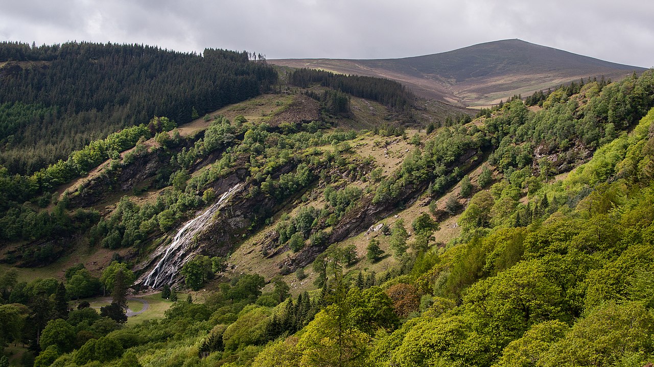
The River Vartry rises on the slopes of Djouce mountain.[2] Nearby, the River Dargle rises between Tonduff and War Hill, falling as the Powerscourt Waterfall, Ireland's second tallest waterfall at 121 metres (397 feet),[45] over a cliff formed by a glacier at the contact point between the granite and mica-schist of the Wicklow Mountains.[46] The waterfalls at the heads of the valleys of Glendalough, Glenmacnass and Glendasan also occur approximately at the schist-granite junctions,[47] as does the Carrawaystick waterfall in Glenmalure.[48]
The River Slaney rises in the North Prison of Lugnaquilla mountain and winds through the Glen of Imaal where it is joined by the Leoh, Knickeen and Little Slaney.[49] Another of its tributaries, the River Derreen, rises on Lugnaquilla's southern side.[50]
Each of the main branches of the River Avoca—the Avonmore, the Avonbeg and the Aughrim rivers—have their origins in smaller tributaries, many of which rise in the Wicklow Mountains.[2] The Glenealo, Glendasan and Annamoe rivers meet to form the Avonmore near Laragh.[2] The Annamoe rises near Sally Gap and is joined by Cloghoge Brook between Lough Tay and Lough Dan and by the River Inchavore in Lough Dan.[2] The Avonbeg rises on Table Mountain and the Three Lakes.[2] The Avonmore and Avonbeg rivers join to form the River Avoca at the Meeting of the Waters in the Vale of Avoca, celebrated in the song The Meeting of the Waters by Thomas Moore.[42] The Avoca is joined by the River Aughrim at Woodenbridge, sometimes referred to as the "Second Meeting of the Waters".[2] The Aughrim is formed at the junction of the Derry Water and the River Ow, the latter of which rises on Lugnaquilla.[2]

Several of these rivers have been dammed to create reservoirs to provide drinking water for the residents of Dublin and its environs. The first of these was the River Vartry, dammed to create the Vartry Reservoir near Roundwood in the 1860s.[51] A second dam was added in 1924 to increase capacity.[51] The River Dodder feeds the two Bohernabreena reservoirs in the northern foothills of the Wicklow Mountains at Glenasmole in County Dublin, which were constructed between 1883 and 1887 to supply water to the townland of Rathmines.[52] The Poulaphouca Reservoir, on the River Liffey near Blessington, was constructed between 1938 and 1940.[53] There are also two hydroelectricity plants at Poulaphouca, constructed during the 1940s.[54] A pumped-storage hydroelectricity plant was constructed at Turlough Hill between 1968 and 1974.[55] Water is pumped up from Lough Nanahangan, a natural corrie lake, into an artificial reservoir on Tomaneena mountain and released at times of peak electricity demand.[56][57]
In common with the rest of Ireland, the Wicklow Mountains experience a temperate oceanic climate with mild, damp summers and cool, wet winters.[58] Annual rainfall reaches 2,000 mm (79 inches) on the highest mountains with the more westerly peaks getting the most rainfall (for example, Djouce mountain, in the east, receives approximately 1,630 mm (64 inches), whereas Duff Hill, in the west, receives approximately 1,950 mm (77 inches) a year).[59] June and July are generally the driest months and there is an average of four hours of sunshine a day over the entire year.[60] Snow cover in winter can reach an average of 50 days a year on the highest peaks.[60] Strong winds are an important factor in peat erosion on the summits.[59]

The primary habitat of the uplands consists of heath and bog. The mountain blanket bogs formed around 4,000 years ago as a result of a combination of climate change and human activity.[61] Prior to this, the mountains were cloaked with pine forest.[61] A change in the climate to wetter and milder weather left the ground waterlogged and leached nutrients from the soil, leading to the formation of peat.[62] Mountain blanket bog is found in areas above 200 metres (660 feet) in altitude and where there are more than 175 days rainfall a year.[62] The most important builders of peat are the Sphagnum bog mosses.[63] Carnivorous plants such as sundews and butterworts are specific to boglands and bog asphodel and bog cotton are also common.[62] Bog water is important for the reproduction of dragonflies and damselflies and the Wicklow mountain bogs also support insects such as pond skaters, whirligig beetles, water boatmen and midges as well as the common frog and the viviparous lizard.[64] Wading birds such as snipes, curlews and golden plover feed in the waterlogged bogland.[65]
Due to drainage of water from the bogs as a result of human activity, most of Wicklow's peat has dried out too much for Sphagnum mosses to grow and moorland and heath vegetation has taken over.[66] Active peat building is still occurring at some sites, most notably the Liffey Head Bog.[62] Common heather (or ling) and bell heather are the most common moorland plants along with bilberry (or fraughan, as it is known in Ireland), bog cotton, deergrass and purple moor grass.[66] Bird species found on the Wicklow moorland include red grouse, meadow pipit and skylark.[67] Birds of prey found in the uplands include kestrels, hen harriers, merlins and peregrine falcons.[65] The latter of these are protected species.[68] The uplands are used for sheep grazing and so the moorland is periodically burned to keep the growth of heather in check and encourage growth of grasses.[69]

Red deer, once native to Wicklow but hunted to extinction, were reintroduced on the Powerscourt Estate in the 18th century.[70] Japanese sika deer were also imported by the Powerscourt Estate and have interbred with the red deer.[70] All deer found in the Wicklow Mountains are descended from the Powerscourt herd and are either sika deer or hybrid red-sika deer.[71] Other mammals occurring include feral goats, mountain hares, badgers, stoats, otters, red squirrels, grey squirrels and bats.[72] The Irish elk is an extinct species of deer that lived in the Wicklow Mountains c. 11,000 years ago, remains of which were discovered in great quantities in Ballybetagh Bog near Glencullen.[73] Wolves were also once native to the mountains but were hunted to extinction in Ireland: the last wolf in Wicklow was killed at Glendalough in 1710.[74]

Widespread clearance of forest began in the Bronze Age and continued up until the early 20th century.[75] Afforestation programmes began in the 1920s and accelerated in the 1950s with the widespread planting of conifer forest, especially in upland moorland areas previously considered unsuitable for planting.[76] The dominant tree is the sitka spruce, accounting for 58% of forest plantations,[77] with lodgepole pine, Norway spruce, Scots pine, larch and Douglas fir also planted.[78] Biodiversity is low in the conifer plantations because they are not native tree species.[78] Broadleaf plantations are rare, accounting for less than 10% of forest.[77]
The young rivers in the upper glens are spawning grounds for salmon and brown trout.[79] Arctic char, isolated in the Wicklow lakes following the end of the last ice age,[80] have been recorded in Lough Dan and the lakes of Glendalough but are now believed extinct.[79] A programme to reintroduce them into the Upper Lake at Glendalough commenced in 2009.[81]

The earliest evidence of human activity in the interior of Wicklow dates to around 4,300 BCE.[82] Passage tombs, from the Neolithic period, are the earliest and most prominent feature of prehistoric Irish civilisation in the Wicklow Mountains.[83] These tombs sit on many of the western and northern summits between Saggart in Dublin and Baltinglass in Wicklow, such as at Seefin and Seefingan.[84] Archaeologist Geraldine Stout has suggested they had a territorial marking function, much like modern-day border posts.[85] Other prehistoric monuments to be found in the uplands include stone circles, standing stones and rock art.[86] The presence of standing stones at altitudes suggests they may have served route-marking purposes.[87] The largest complex of hill forts in Ireland is to be found on the hills near Baltinglass.[87]
The earliest known tribes to have controlled the Wicklow Mountains include the Dál Messin Corb, the Uí Mail, the Uí Theig and the Uí Briúin.[88] One member of the Dál Messin Corb was Saint Kevin, who founded the monastery at Glendalough in the latter part of the 6th century.[88] Kevin travelled to Glendalough from Hollywood, crossing the mountains via the Wicklow Gap.[89] By the 8th century, Glendalough had grown into a substantial settlement of 500–1,000 people and an important site of learning and pilgrimage.[90] Monasteries were often attacked, especially at times of disease or famine, and Glendalough's wealth made it a frequent target for both local tribes and, later, Norse invaders.[91] The monastery declined in importance after the arrival of the Normans in the 12th century and its subsequent annexation to the Archdiocese of Dublin.[92] It was burned by the English in 1398, although settlement there continued until the end of the 16th century.[92] There are also important early Irish church sites in the Dublin foothills of the Wicklow Mountains at Rathmichael and Tully.[93]
In 1170, during the Norman invasion of Ireland, Strongbow and Dermot MacMurrough successfully laid siege to Dublin by following a high route through the Wicklow Mountains, avoiding the defences along the normal route to the west of the mountains.[94] The Norman invasion displaced two important Gaelic clans from Kildare, the O'Byrnes and the O'Tooles, who moved into the Wicklow Mountains, the O'Byrnes in the east and the O'Tooles in the west.[95] From their mountain strongholds both families conducted a persistent campaign of harassment against the invaders and the Wicklow Mountains became known as the terra guerre ("land of war"), as opposed to the terra pacis ("land of peace") of the settled lowlands.[96]
The valley of Glenmalure provided an almost unassailable refuge for the clans and English forces suffered heavy defeats there, first in 1274 and again in 1580 in the Battle of Glenmalure.[97][98] The latter defeat was at the hands of Fiach McHugh O'Byrne, who led many attacks against the English and assisted in the escapes of many of the hostages held by the English to guarantee the loyalty of the Irish clans.[99] One such hostage was Red Hugh O'Donnell, who escaped from Dublin Castle on the night of 6 January 1592 in the company of Art O'Neill.[98] The two men crossed the mountains in blizzard conditions, making for Fiach McHugh O'Byrne's stronghold at Glenmalure.[98] Art O'Neill died from exposure during the journey and Red Hugh had several toes amputated due to frostbite.[100] A cross and a plaque to the north of Conavalla mountain mark the place where Art O'Neill perished and an annual walk is now held following in the two men's footsteps.[101] The O'Byrnes' and O'Tooles' dominance finally came to an end with the Act of Succession of 1652 when their land was confiscated by the English Commonwealth.[102]

A prolonged period of peace reigned in the Wicklow Mountains from the end of the Cromwellian period until the 1798 Rising.[103] Although the main rebellion was quickly defeated, Irish rebels once again used the Wicklow Mountains as a hiding place and stronghold to attack the English for many years afterwards.[104] Among their number was Michael Dwyer, a native of the Wicklow Mountains, born in the townland of Camara in the Glen of Imaal, and General Joseph Holt.[105] Both men eventually surrendered and were transported to Australia.[105] Determined to prevent any future rebel activity, a military road through the mountains, similar to those built in the Scottish Highlands to quell the Jacobite risings, was proposed by the British government to enable troops to be deployed quickly into the region.[106] The Wicklow Military Road was constructed between 1800 and 1809 and runs from Rathfarnham, County Dublin to Aghavannagh, County Wicklow via Glencree, the Sally Gap and Laragh.[107] A series of army barracks and police stations were built along the route, although they were little used and soon fell into disrepair as the Wicklow Mountains soon ceased to be a centre of rebel activity after the road was completed.[107]
The census of 1841 recorded a population of 13,000 in the Wicklow uplands out of 126,143 persons in the county as a whole.[108] Following the Great Famine, the census of 1891 showed that the population of County Wicklow had declined to 62,136 with the proportionate fall in the uplands regions even greater as the populace deserted the marginal lands.[109]
The construction of the railways in the 19th century led to the development of tourism in the Wicklow Mountains.[109] Visitors were taken by horse-drawn transport into the mountains from the railway station at Rathdrum.[109] Glendalough quickly established itself as the most popular tourist destination and a train service there was considered in 1897 but the proposals came to nothing.[110] The tourism potential of the Military Road was spotted soon after its completion and G. N. Wright's Tours in Ireland (1822) is one of the earliest guides to the sights along the route.[111]

The principal farming activity in the uplands is sheep grazing, using mainly the Wicklow Cheviot breed.[112] Land is also used for forestry and turf cutting.[113] Tourism and recreation are also major activities in the uplands. Glendalough remains the most popular destination, receiving around one million visitors each year.[114] Recreational activities in the mountains include walking, rock climbing, winter climbing, fishing and cycling.[115] Hillwalking in the Wicklow Mountains was first popularised by J. B. Malone through a weekly column he wrote in the Evening Herald newspaper.[116] Malone was later instrumental in the creation of the Wicklow Way, Ireland's first National Waymarked Trail, which opened in 1980 and crosses the Wicklow Mountains.[116] The Wicklow Way has been joined by the Dublin Mountains Way and the Saint Kevin's Way pilgrim path, both of which also traverse parts of the mountains.[117][118]
On foot of concerns about environmental degradation and undesirable development of the Wicklow Uplands, the Government announced the creation of the Wicklow Mountains National Park in 1990 to conserve the area's biodiversity and landscape.[119] The park was officially established in 1991 and now encompasses an area of over 20,000 hectares (200 square kilometres; 77 square miles).[120] In addition, the Wicklow Mountains (including areas outside the National Park) are classed as a Special Area of Conservation under the EU Habitats Directive and as a Special Protection Area under the EU Birds Directive.[121]
The Dublin foothills of the Wicklow Mountains are managed by the Dublin Mountains Partnership (DMP), a group established in May 2008 with the aim of improving the recreational experience of users of the Dublin Mountains.[122] Its members include representatives of state agencies, local authorities and recreational users.[122] The DMP has restored paths and developed walking trails, orienteering courses and a mountain biking course.[123]