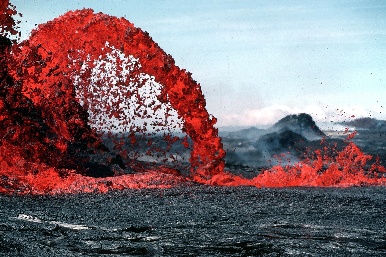
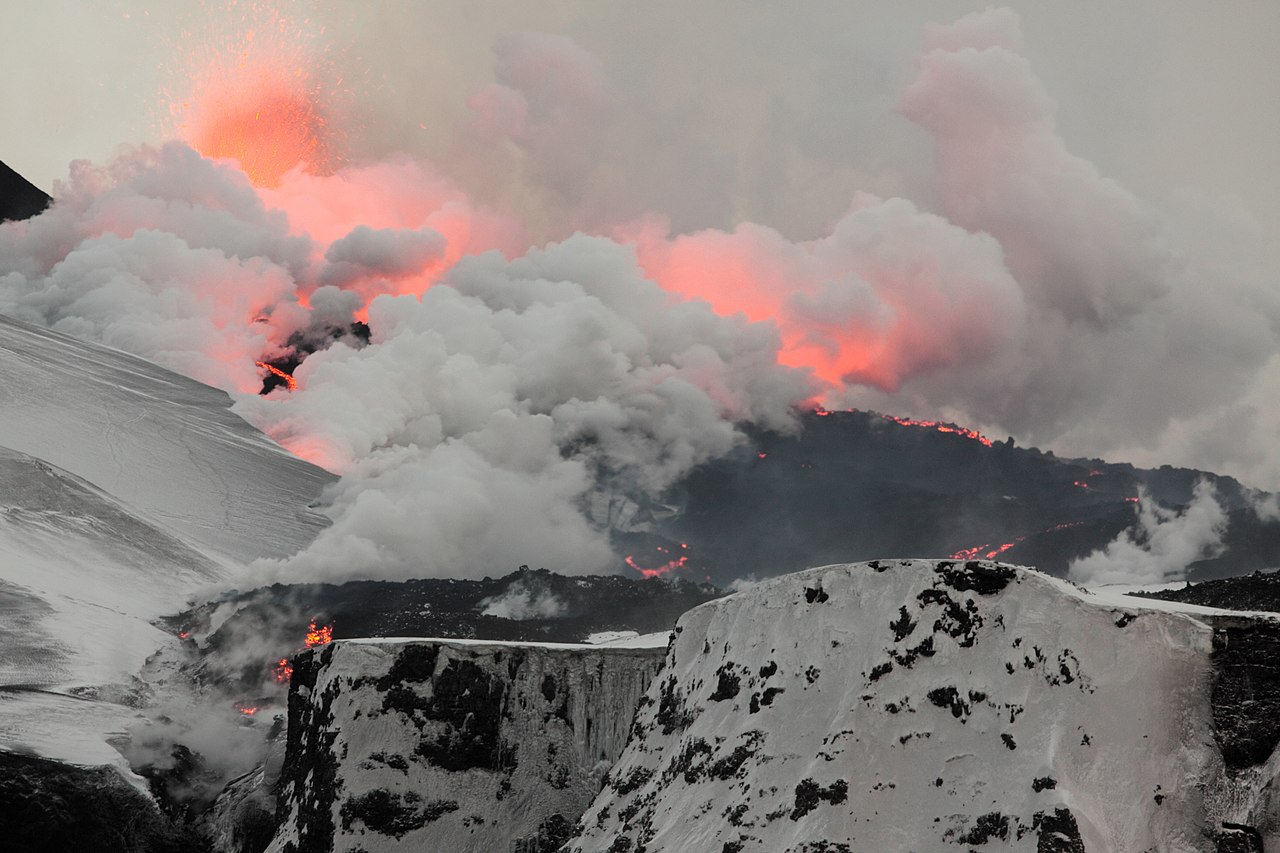
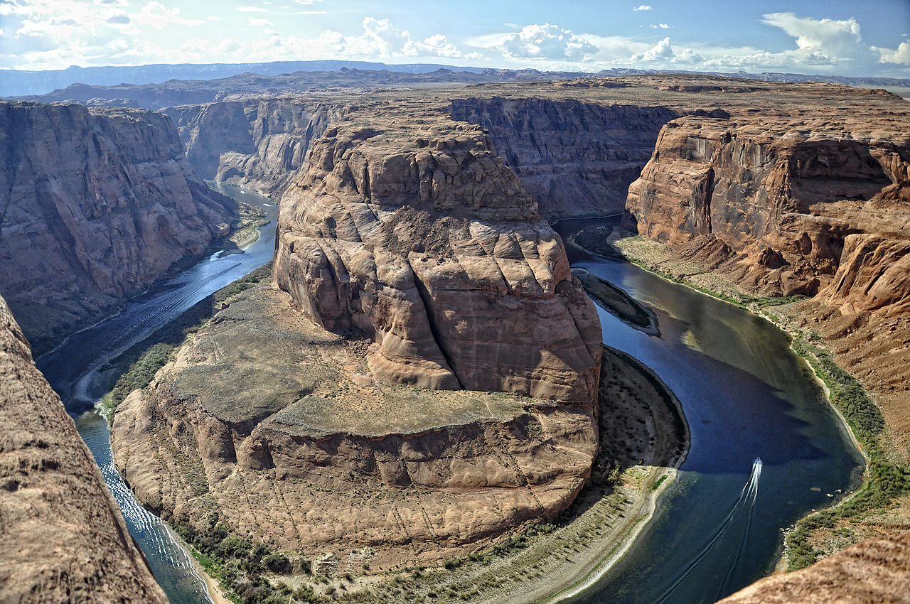
stringtranslate.com

Портал:Геология

Геологический портал

  • П:ГЕОЛ

Геология (от др.-греч. γῆ ( )  'земля' и λoγία ( -logía )  'изучение, рассуждение') — раздел естественных наук , изучающий Землю и другие астрономические объекты , породы, из которых они состоят, и процессы, посредством которых они изменяются с течением времени. Современная геология в значительной степени пересекается со всеми другими науками о Земле , включая гидрологию . Она интегрирована с наукой о системе Земли и планетологией .

Геология описывает структуру Земли на ее поверхности и под ней, а также процессы, которые сформировали эту структуру. Геологи изучают минералогический состав горных пород, чтобы получить представление об истории их формирования. Геология определяет относительный возраст горных пород, обнаруженных в данном месте; геохимия (раздел геологии) определяет их абсолютный возраст . Объединяя различные петрологические, кристаллографические и палеонтологические инструменты, геологи способны вести хронику геологической истории Земли в целом. Одним из аспектов является демонстрация возраста Земли . Геология предоставляет доказательства тектоники плит , эволюционной истории жизни и прошлых климатов Земли .

Геологи широко изучают свойства и процессы Земли и других планет земной группы. Геологи используют широкий спектр методов для понимания структуры и эволюции Земли, включая полевые работы , описание горных пород , геофизические методы , химический анализ , физические эксперименты и численное моделирование . С практической точки зрения геология важна для разведки и эксплуатации полезных ископаемых и углеводородов , оценки водных ресурсов , понимания стихийных бедствий , устранения экологических проблем и предоставления информации о прошлых изменениях климата . Геология является основной академической дисциплиной , и она является центральной для геологической инженерии и играет важную роль в геотехнической инженерии . ( Полная статья... )

Обновить с новыми вариантами ниже (очистить)

Признанный контент -@media screen{html.skin-theme-clientpref-night .mw-parser-output div:not(.notheme)>.tmp-color,html.skin-theme-clientpref-night .mw-parser-output p>.tmp-color,html.skin-theme-clientpref-night .mw-parser-output table:not(.notheme) .tmp-color{color:inherit!important}}@media screen и (prefers-color-scheme:dark){html.skin-theme-clientpref-os .mw-parser-output div:not(.notheme)>.tmp-color,html.skin-theme-clientpref-os .mw-parser-output p>.tmp-color,html.skin-theme-clientpref-os .mw-parser-output table:not(.notheme) .tmp-color{color:inherit!important}}загрузить новый пакет

Здесь представлены статьи категорий «хорошо» и «избранное» , которые соответствуют основным высоким редакционным стандартам.

  • Над горой извергается столб серого пепла
    Извержение вулкана Пинатубо в 1991 году , крупнейшее извержение с 1912 года, затмевается извержениями в этом списке.


    При извержении вулкана из жерла и трещины выбрасываются лава, вулканические бомбы, пепел и различные газы. Хотя многие извержения представляют опасность только для непосредственно прилегающей территории, крупнейшие извержения Земли могут иметь серьезные региональные или даже глобальные последствия, некоторые из них влияют на климат и способствуют массовым вымираниям . Вулканические извержения обычно можно охарактеризовать как взрывные извержения , внезапные выбросы камней и пепла, или эффузивные извержения , относительно мягкие излияния лавы. Ниже приведен отдельный список для каждого типа. Вероятно, за всю историю Земли было много таких извержений, помимо тех, что указаны в этих списках. Однако эрозия и тектоника плит сделали свое дело, и многие извержения не оставили геологам достаточно доказательств, чтобы установить их размер. Даже для извержений, перечисленных здесь, оценки извергнутого объема могут быть подвержены значительной неопределенности. ( Полная статья... )

  • An ice core being slid out of a drill barrel sideways
    Образец ледяного керна, взятый из буровой скважины

    An ice core is a core sample that is typically removed from an ice sheet or a high mountain glacier. Since the ice forms from the incremental buildup of annual layers of snow, lower layers are older than upper ones, and an ice core contains ice formed over a range of years. Cores are drilled with hand augers (for shallow holes) or powered drills; they can reach depths of over two miles (3.2 km), and contain ice up to 800,000 years old.

    The physical properties of the ice and of material trapped in it can be used to reconstruct the climate over the age range of the core. The proportions of different oxygen and hydrogen isotopes provide information about ancient temperatures, and the air trapped in tiny bubbles can be analysed to determine the level of atmospheric gases such as carbon dioxide. Since heat flow in a large ice sheet is very slow, the borehole temperature is another indicator of temperature in the past. These data can be combined to find the climate model that best fits all the available data. (Full article...)
  • The Toronto Magnetic and Meteorological Observatory on the grounds of the University of Toronto

    The Toronto Magnetic and Meteorological Observatory is a historical observatory located on the grounds of the University of Toronto, in Toronto, Ontario, Canada. The original building was constructed in 1840 as part of a worldwide research project run by Edward Sabine to determine the cause of fluctuations in magnetic declination. Measurements from the Toronto site demonstrated that sunspots were responsible for this effect on Earth's magnetic field. When this project concluded in 1853, the observatory was greatly expanded by the Canadian government and served as the country's primary meteorological station and official timekeeper for over fifty years. The observatory is considered the birthplace of Canadian astronomy. (Full article...)

  • The Qayen earthquake, also known as the Ardekul or Qaen earthquake, struck northern Iran's Khorasan Province in the vicinity of Qaen on May 10, 1997 at 07:57 UTC (12:57 local time). The largest in the area since 1990, the earthquake registered 7.3 on the moment magnitude scale and was centered approximately 270 kilometers (170 mi) south of Mashhad on the village of Ardekul. The third earthquake that year to cause severe damage, it devastated the Birjand–Qayen region, killing 1,567 and injuring more than 2,300. The earthquake—which left 50,000 homeless and damaged or destroyed over 15,000 homes—was described as the deadliest of 1997 by the United States Geological Survey. Some 155 aftershocks caused further destruction and drove away survivors. The earthquake was later discovered to have been caused by a rupture along a fault that runs underneath the Iran–Afghanistan border.

    Damage was eventually estimated at $100 million, and many countries responded to the emergency with donations of blankets, tents, clothing, and food. Rescue teams were also dispatched to assist local volunteers in finding survivors trapped under the debris. The destruction around the earthquake's epicenter was, in places, almost total; this has been attributed to poor construction practices in rural areas, and imparted momentum to a growing movement for changes in building codes for earthquake-safe buildings. With 1 in 3,000 deaths in Iran attributable to earthquakes, a US geophysicist has suggested that a country-wide rebuilding program would be needed to address the ongoing public safety concerns. (Full article...)

  • Kathryn Dwyer Sullivan (born October 3, 1951) is an American geologist, oceanographer, and former NASA astronaut and US Navy officer. She was a crew member on three Space Shuttle missions.

    A graduate of University of California, Santa Cruz, in the United States, and Dalhousie University in Nova Scotia, Canada—where she earned a Doctor of Philosophy degree in geology in 1978—Sullivan was selected as one of the six women among the 35 astronaut candidate in NASA Astronaut Group 8, the first group to include women. During her training, she became the first woman to be certified to wear a United States Air Force pressure suit, and on July 1, 1979, she set an unofficial sustained American aviation altitude record for women. During her first mission, STS-41-G, Sullivan performed the first extra-vehicular activity (EVA) by an American woman. On her second, STS-31, she helped deploy the Hubble Space Telescope. On the third, STS-45, she served as Payload Commander on the first Spacelab mission dedicated to NASA's Mission to Planet Earth. (Full article...)

  • An earthquake occurred on November 27, 2005, at 13:52 IRST (10:22 UTC) on the sparsely populated Qeshm Island off Southern Iran, killing 13 people and devastating 13 villages. It was Iran's second major earthquake of 2005, following the one at Zarand in February. The epicenter was about 1,500 kilometers (930 mi) south of Tehran, close to Iran's southern borders. Initial measurements showed that the earthquake registered about 6.0 on the moment magnitude scale, although that was reduced to 5.8 after further analysis. More than 400 minor aftershocks followed the main quake, 36 of which were greater than magnitude 2.5. The earthquake occurred in a remote area during the middle of the day, limiting the number of fatalities. Iranian relief efforts were effective and largely adequate, leading the country to decline offers of support from other nations and UNICEF.

    Qeshm Island is part of the Simply Folded Belt, the most seismically active part of the Zagros fold and thrust belt. Similar to most earthquakes in the area, the 2005 event resulted from reverse slip faulting. Since it lies in such a seismically active area, there is a high risk of destructive earthquakes in Iran; 1 in 3,000 deaths are attributable to earthquakes. One geophysicist has cited the lack of strict building codes as a serious concern. (Full article...)

  • Aerial view of Cerro Azul from the west.

    Cerro Azul (Spanish pronunciation: [ˈsero aˈsul], blue hill in Spanish), sometimes referred to as Quizapu, is an active stratovolcano in the Maule Region of central Chile, immediately south of Descabezado Grande. Part of the South Volcanic Zone of the Andes, its summit is 3,788 meters (12,428 ft) above sea level, and is capped by a summit crater that is 500 meters (1,600 ft) wide and opens to the north. Beneath the summit, the volcano features numerous scoria cones and flank vents.

    Cerro Azul is responsible for several of South America's largest recorded eruptions, in 1846 and 1932. In 1846, an effusive eruption formed the vent at the site of present-day Quizapu crater on the northern flank of Cerro Azul and sent lava flowing down the sides of the volcano, creating a lava field 8–9 square kilometres (3–3.5 square miles) in area. Phreatic and Strombolian volcanism between 1907 and 1932 excavated this crater. In 1932, one of the largest explosive eruptions of the 20th century occurred at Quizapu Crater and sent 9.5 cubic kilometers (2.3 cu mi) of ash into the atmosphere. The volcano's most recent eruption was in 1967. (Full article...)

  • An earthquake struck Western Greece near the coastal city of Aigio at 03:15:48 local time on 15 June 1995. The second destructive earthquake to strike Greece in a month, it measured 6.4–6.5 on the moment magnitude scale (Mw ). It was assigned a maximum Modified Mercalli intensity of VIII (Severe) and EMS-98 intensity of IX (Destructive). The horizontal peak ground acceleration reached 0.54 g and ground velocity peaked at 52 cm/s (20 in/s)—the strongest ground motion ever recorded in Greece. Fifteen minutes after the mainshock, a large aftershock struck, causing further damage to Aigio. Faulting occurred on either the Aigion fault or an unnamed offshore fault. Other faults in the region have the potential to produce earthquakes up to Mw  6.9, which poses a risk to Aigio and the surrounding Gulf of Corinth.

    Monetary damages from the earthquake reached $660 million (in 1995 USD). Significant destruction occurred; the collapse of two buildings left 26 dead and up to 200 injured. In the aftermath, several countries and organizations provided disaster aid, including search and rescue and refugee assistance operations. Many countries also donated medical supplies, temporary shelter, water treatment equipment, and a ship to house survivors. The Greek government issued seismic loans to aid in the rebuilding of Aigio, though it may have encouraged the construction of taller buildings—increasing Aigio's future seismic hazard. Controversy arose over the lack of a warning for the earthquake, as several sources warned officials that a major earthquake would occur. (Full article...)
  • Map of SSSIs in Cornwall within the UK
    Map of SSSIs in Cornwall within the UK

    There are 167 Sites of Special Scientific Interest (SSSIs) in Cornwall (including the Isles of Scilly). Cornwall, in the south-west of England, UK, has a population of 575,413 (2022) across an area of 3,545 km2 (875,988.6 acres), making it one of the least densely populated counties within England. The north coast of Cornwall falls on the Celtic Sea in the Atlantic Ocean, which also surrounds the Isles of Scilly, the south coast falls on the English Channel and the county is bounded by the River Tamar, forming the border with Devon, to the east. Cornish geology consists mainly of rocks from the Devonian and Carboniferous geological periods. Granite forms a large part of these, with mineralisations of tin, copper, lead and arsenic having been mined in the area. This gives rise to many distinct habitats, with strong marine influences, including sand dunes, rocky reefs, stacks and headlands as well as heathland, moorland and unusual river profiles.

    In England the body responsible for designating SSSIs is Natural England, which chooses a site "because of its flora, fauna, or geological or physiographical features". Natural England took over the role of designating and managing SSSIs from English Nature in October 2006 when it was formed from the amalgamation of English Nature, parts of the Countryside Agency and the Rural Development Service. Natural England, like its predecessor, uses the 1974–96 county system and as such the same approach is followed here, rather than adopting the current local government or ceremonial county boundaries. (Full article...)

  • Bryce Canyon National Park (/brs/) is a national park of the United States located in southwestern Utah. The major feature of the park is Bryce Canyon, which despite its name, is not a canyon, but a collection of giant natural amphitheaters along the eastern side of the Paunsaugunt Plateau. Bryce is distinctive due to geological structures called hoodoos, formed by frost weathering and stream erosion of the river and lake bed sedimentary rock. The red, orange, and white colors of the rocks provide spectacular views for park visitors. Bryce Canyon National Park is much smaller and sits at a much higher elevation than nearby Zion National Park. The rim at Bryce varies from 8,000 to 9,000 feet (2,400 to 2,700 m).

    The Bryce Canyon area was settled by Mormon pioneers in the 1850s and was named after Ebenezer Bryce, who homesteaded in the area in 1874. The area was originally designated as a national monument by President Warren G. Harding in 1923 and was redesignated as a national park by Congress in 1928. The park covers 35,835 acres (55.992 sq mi; 14,502 ha; 145.02 km2) and receives substantially fewer visitors than Zion National Park (nearly 4.3 million in 2016) or Grand Canyon National Park (almost 6 million in 2016), largely due to Bryce's more remote location. In 2023, Bryce Canyon received 2,461,269. (Full article...)

Жизненно важная статья

Важнейшие статьи для понимания геологии.

Землетрясение 1867 года на Манхэттене произошло в округе Райли, штат Канзас , в Соединенных Штатах, 24 апреля 1867 года в 20:22 UTC или около 14:30 по местному времени . Это было сильнейшее землетрясение, произошедшее в штате, его магнитуда составила 5,1 по сейсмической шкале , которая основана на изосейсмической карте или зоне ощутимого события. Эпицентр землетрясения находился недалеко от города Манхэттен . ( Полная статья... )

Связанные порталы

Примите участие

Для получения ресурсов редактора и сотрудничества с другими редакторами по улучшению статей Википедии, связанных с геологией, посетите WikiProject Geology .

Избранная биография

Избранные биографические статьи в разделе «Геология»

Мэрион Кинг Хабберт (5 октября 1903 г. – 11 октября 1989 г.) был американским геологом и геофизиком. Он работал висследовательской лаборатории Shell в Хьюстоне , штат Техас . Он внес несколько важных вкладов в геологию , геофизику и геологию нефти , наиболее примечательными из которых являются кривая Хабберта и теория пика Хабберта (основной компонент пика нефти ), с важными политическими последствиями. Его часто называли «М. Кинг Хабберт» или «Король Хабберт». ( Полная статья... )

Вы знали

Знаете ли вы это о геологии?

Топ-10 WikiProject Geology Популярные статьи месяца

Следующая статья по геологии является одной из самых посещаемых статей WikiProject Geology . Полный список см. на Wikipedia:WikiProject Geology/Популярные страницы .

Избранные фотографии

Нажмите, чтобы увеличить и просмотреть описание.

Основные статьи

Категории

Выберите [►] для просмотра подкатегорий.

Избранные фотографии

Ассоциированные Викимедиа

Более подробную информацию по этой теме можно найти в следующих родственных проектах Фонда Викимедиа :


  • Бесплатный репозиторий Commons
  • Wikibooks
    Бесплатные учебники и руководства
  • Wikidata
    Бесплатная база знаний
  • Wikinews
    Новости свободного контента
  • Wikiquote
    Коллекция цитат
  • Wikisource
    Библиотека свободного контента
  • Wikiversity
    Бесплатные инструменты обучения
  • Wikivoyage
    Бесплатный путеводитель
  • Викисловарь
    и тезаурус

Откройте для себя Википедию с помощью порталов

Очистить кэш сервера