Гаррисберг ( / ˈ h æ r ɪ s ˌ b ɜːr ɡ / , пенсильванский немецкий : Harrisbarrig ) является столицей Содружества США Пенсильвания и центром округа Дофин . С населением 50 099 человек по состоянию на 2020 год Гаррисберг является девятым по численности населения городом в Пенсильвании . Это крупный главный город столичного статистического района Гаррисберг-Карлайл , также известного как долина Саскуэханна , в котором в 2020 году проживало 591 712 человек, и это четвёртый по численности населения столичный район в Пенсильвании. [8] Гаррисберг расположен на восточном берегу реки Саскуэханна , в 83 милях (134 км) к юго-западу от Аллентауна и в 107 милях (172 км) к северо-западу от Филадельфии .
Харрисберг сыграл свою роль в американской истории во время миграции на Запад , Гражданской войны в США и Промышленной революции . В течение части 19-го века строительство Пенсильванского канала , а затем Пенсильванской железной дороги позволило Харрисбергу превратиться в один из самых индустриализированных городов на северо-востоке США . В середине и конце 20-го века экономическое положение города колебалось, его основными отраслями промышленности были правительство, тяжелая промышленность , сельское хозяйство и общественное питание. Эти экономические колебания способствовали тому, что Харрисберг пережил сокращение почти половины своего населения в период с 1950 по 2000 год. Тем не менее, регион считается финансово стабильным отчасти из-за высокой концентрации государственных и федеральных правительственных учреждений. [9]
Pennsylvania Farm Show , крупнейшая в США выставка сельскохозяйственной продукции в помещении, впервые прошла в Гаррисберге в 1917 году и с тех пор проводится там каждый год с начала до середины января. [10] В городе также ежегодно проводится Great American Outdoor Show , крупнейшая в мире выставка такого рода, а также множество других мероприятий. 28 марта 1979 года в Гаррисберге, в соседнем Мидлтауне , произошел несчастный случай на Три-Майл-Айленде .
Считается, что территория Гаррисберга вдоль реки Саскуэханна была заселена коренными американцами еще в 3000 году до нашей эры. Известная коренным американцам как «Пейкстин» или « Пакстанг », эта местность была важным местом отдыха и перекрестком для индейских торговцев, где пересекались тропы, ведущие от Делавэра к рекам Огайо и от Потомака к Верхней Саскуэханне .
Первый контакт европейцев с коренными американцами в Пенсильвании был осуществлен англичанином капитаном Джоном Смитом , который в 1608 году отправился из Вирджинии вверх по реке Саскуэханна и посетил племя Саскуэханна .
В 1719 году Джон Харрис-старший , английский торговец, поселился здесь и 14 лет спустя получил гранты в размере 800 акров (3,2 км 2 ) в этом районе. В 1785 году Джон Харрис-младший задумал заложить город на земле своего отца, который он назвал Харрисберг. Весной 1785 года город был официально обследован Уильямом Маклеем , зятем Джона Харриса-старшего. В 1791 году Харрисберг стал корпорацией, а в октябре 1812 года он был назван столицей штата Пенсильвания, каковой он и остается с тех пор. Сбор здесь весьма секционного Харрисбергского съезда в 1827 году (что, возможно, стало рождением лоббирования в национальном масштабе) привел к принятию законопроекта о высоких протекционистских тарифах 1828 года. [11]
В 1839 году на первом национальном съезде Партии вигов США, который состоялся в Гаррисберге , Уильям Генри Гаррисон и Джон Тайлер были выдвинуты на посты президента и вице-президента США .
_5_dollars_1848_urn-3_HBS.Baker.AC_1142145.jpeg/1280px-Recto_Harrisburg_Bank_(Pennsylvania)_5_dollars_1848_urn-3_HBS.Baker.AC_1142145.jpeg)
До того, как в Харрисберге появились первые промышленные предприятия, это был живописный, пасторальный город: компактный и окруженный сельскохозяйственными угодьями. В 1822 году впечатляющий кирпичный капитолий был завершен за 200 000 долларов (~ 5,78 млн долларов в 2023 году). [12]
Стратегическое расположение Гаррисберга давало ему преимущество перед многими другими городами; он был основан как торговый пост в 1719 году в месте, важном для расширения на запад, за горным хребтом Голубых гор . Река Саскуэханна в этом месте в основном текла с запада на восток, обеспечивая путь для лодочного сообщения с востока. Головной пункт навигации находился на небольшом расстоянии к северо-западу от города, где река протекала через перевал. Лица, прибывающие с востока на лодке, должны были выходить в Гаррисберге и готовиться к сухопутному путешествию на запад через горный перевал. Гаррисберг приобрел значение как пункт снабжения продовольствием в этой точке, где направлявшиеся на запад пионеры переходили от речного путешествия к сухопутному. Отчасти из-за его стратегического расположения законодательный орган штата выбрал небольшой город Гаррисберг столицей штата в 1812 году.
Величие Капитолия колониального возрождения доминировало в этом причудливом городе. Улицы были грязными, но упорядоченными и вымощенными сеткой. Пенсильванский канал был построен в 1834 году и тянулся вдоль города. Жилые дома располагались всего в нескольких городских кварталах, простирающихся к югу от Капитолия. Они были в основном одноэтажными. Фабрик не было, но были кузницы и другие предприятия. [13] Право собственности на землю сосредоточилось в руках небольшого числа богатых семей: в 1850 году пять человек владели одной третью частной земли. [14]
В первой половине XIX века Гаррисберг был важным остановочным пунктом на Подземной железной дороге , где люди, спасавшиеся от рабства, использовали реку Саскуэханна для получения продовольствия и припасов, прежде чем отправиться на север в Канаду. [15]
Во время Гражданской войны в США Гаррисберг был важным учебным центром для армии Союза , через лагерь Кертин прошли десятки тысяч солдат . Он также был крупным железнодорожным центром Союза и жизненно важным связующим звеном между Атлантическим побережьем и Средним Западом, с несколькими железными дорогами, проходящими через город и охватывающими реку Саскуэханна. В результате этой важности он был целью армии генерала Роберта Э. Ли из Северной Вирджинии во время ее двух вторжений. Первый раз во время Мэрилендской кампании 1862 года , когда Ли планировал захватить город после взятия Харперс-Ферри, Западная Вирджиния , но ему помешала битва при Энтитеме и его последующее отступление обратно в Вирджинию. Вторая попытка была предпринята во время Геттисбергской кампании в 1863 году и была более существенной. По прямому приказу генерала Роберта Э. Ли, Второму корпусу генерал-лейтенанта Конфедерации Ричарда С. Юэлла было поручено захватить Харрисберг и нарушить жизненно важные линии снабжения и железнодорожные линии Союза. Однако силы Юэлла были перехвачены войсками Департамента Саскуэханна под командованием генерал-майора Союза Дариуса Н. Кауча в серии стычек вокруг города, таких как стычка у Спортинг-Хилла в Кэмп-Хилле , всего в 2 милях (3 км) к западу от Харрисберга. Второму корпусу в конечном итоге не удалось ни преодолеть местную оборону Союза, ни пересечь раздутую дождем Саскуэханну в сам Харрисберг, и он был вынужден отступить на юг, чтобы перегруппироваться с основными силами Конфедерации Ли. Эта попытка ознаменовала самое северное наступление армии Конфедерации во время Гражданской войны.
3 июля 1863 года артиллерийский обстрел, ознаменовавший начало атаки Пикетта в битве при Геттисберге, был слышен из Гаррисберга, находящегося почти в 40 милях. [16]
Значение Гаррисберга во второй половине 19-го века заключалось в сталелитейной промышленности. Он также был важным железнодорожным центром. Сталь и железо стали доминирующими отраслями промышленности. Сталелитейная и другие отрасли промышленности продолжали играть важную роль в местной экономике на протяжении всей второй половины 19-го века. Город был центром огромного железнодорожного движения, а его сталелитейная промышленность поддерживала большие печи, прокатные станы и механические цеха. Завод Pennsylvania Steel Company, который открылся в соседнем Стилтоне в 1866 году, был первым в стране; позже им управляла Bethlehem Steel . [17]
Его первые крупномасштабные литейные заводы были введены в эксплуатацию вскоре после 1850 года. [13] Поскольку промышленность по всей стране вступила в фазу большого расширения и технологического совершенствования, то же самое произошло и с промышленностью — и в частности со сталелитейной промышленностью — в Гаррисберге. Это можно объяснить сочетанием факторов, типичных для других успешных промышленных городов: быстрое развитие железных дорог; близлежащие рынки для товаров; и близлежащие источники для сырья.
С Гаррисбергом, готовым к росту производства стали, Стилтон стал идеальным местом для этого типа промышленности. Это была широкая полоса равнинной земли, расположенная к югу от города, с доступом к железной дороге и каналу на протяжении всей его 4-мильной длины. Там было достаточно места для домов и собственного центра города. Стилтон был городом компании, открытым в 1866 году компанией Pennsylvania Steel Company. Высокоинновационный в своем процессе производства стали, он стал первым заводом в Соединенных Штатах, который производил стальные железнодорожные рельсы по контракту. В период своего расцвета Стилтон был домом для более чем 16 000 жителей из 33 различных этнических групп. Все они были заняты в сталелитейной промышленности или имели работу в службах, которые ее поддерживали. В конце 19 века в Стилтоне располагалось не менее пяти крупных сталелитейных заводов и литейных цехов. Каждый из них имел лабиринт зданий; транспортные средства для перемещения продукции; большие дворы для размещения оборудования; и сооружения для погрузки своей продукции на поезда. Трубы этих заводов постоянно изрыгали дым. Благодаря жилью и небольшому центру города в пешей доступности большинство жителей Стилтона видели эти виды и запахи каждый день.
Железнодорожная станция была еще одним районом Харрисберга, который быстро и основательно изменился в годы индустриализации. Это было широкое пространство из примерно двух десятков железнодорожных путей, которые выросли из одноколейной дороги начала 1850-х годов. К концу 19 века эта территория была шириной около двух городских кварталов и образовала то, что можно было считать барьером вдоль восточной окраины города: проехать по ней можно было только по мосту. Три больших и богато украшенных пассажирских депо были построены таким же количеством железнодорожных линий. Пенсильванская железная дорога была крупнейшей железнодорожной линией в Харрисберге. Она построила огромные ремонтные мастерские и два больших депо в 1860-х и 1870-х годах, чтобы обрабатывать свои огромные грузовые и пассажирские потоки и поддерживать свою колоссальную инфраструктуру. Ее рельсы проходили по всей длине Харрисберга, вдоль его восточной границы. У нее было последовательно три пассажирских депо, каждое из которых было построено на месте предыдущего, и каждое из которых имело архитектуру высокого стиля, включая депо для поезда, чтобы защитить пассажиров от непогоды. На пике популярности в 1904 году она совершала 100 пассажирских остановок в день. Она простиралась на запад до Питтсбурга , через весь штат, и на восток до Филадельфии , обслуживая Стилтон по всему маршруту. Антрацитовые угольные шахты в горах Аллегейни были достигнуты Северной центральной железной дорогой. Железная дорога Ливанской долины простиралась на восток до Филадельфии с ответвлениями до Нью-Йорка . Другой железнодорожной линией была Филадельфия и Редингская железная дорога , которая обслуживала Филадельфию и другие пункты на востоке. [18]
Эллисон-Хилл , первый пригород Харрисберга, расположен к востоку от города на выдающемся утесе, куда можно попасть по мостам через широкую полосу железнодорожных путей. Он был застроен в конце 19 века и предлагал состоятельным жителям Харрисберга возможность жить в пригороде всего в нескольких сотнях ярдов от их работы в городе. По мере того, как город расширялся, он включил Эллисон-Хилл в свои границы. В 1886 году была проложена единственная линия конного трамвая от города до Эллисон-Хилл. Позже легкий доступ был достигнут через мост Стейт-стрит, ведущий на восток от комплекса Капитолия , и мост Маркет-стрит, ведущий от известного делового района города. Среди самых желанных участков Эллисон-Хилл в то время был Маунт-Плезант, который характеризовался большими домами в стиле колониального возрождения с дворами для очень богатых и небольшими, но все же добротно построенными рядными домами, выстилающими главную улицу, для умеренно богатых. State Street, ведущая от Капитолия прямо к Эллисон Хилл, была запланирована так, чтобы обеспечить великолепный вид на купол Капитолия для тех, кто приближается к городу с Эллисон Хилл. Эта тенденция к отдаленным жилым районам началась медленно в конце 19-го века и в основном ограничивалась трамвайной линией, но растущее распространение владения автомобилями ускорило эту тенденцию и рассредоточило население в 20-м веке.

В начале 20 века город Гаррисберг нуждался в переменах. Без надлежащих санитарных условий такие болезни, как тиф, начали убивать многих жителей Гаррисберга. Увидев эти необходимые изменения, несколько жителей Гаррисберга стали участвовать в движении «Красивый город» . Проект был сосредоточен на обеспечении лучшей транспортной доступности, мест для отдыха, санитарии, озеленения и парков для тех, кто живет в городах, поскольку исследования показали, что человек, имеющий доступ к удобствам, будет более счастливым человеком . [19] В декабре 1900 года реформатор по имени Мира Ллойд Док , которая недавно столкнулась с хорошо организованными городскими центрами во время международной поездки в Европу, прочитала лекцию на тему «Красивый город» в Торговой палате Гаррисберга. [19] Другие видные граждане города, такие как Дж. Хорас Макфарланд и Вэнс Маккормик, выступали за городские улучшения, на которые повлияли европейский дизайн городского планирования и Всемирная Колумбийская выставка . Уоррен Мэннинг был нанят, чтобы помочь осуществить эти изменения. В частности, их усилия значительно расширили парковую систему Харрисберга, создав парк Риверфронт, парк Резервуар, Итальянское озеро и парк Уайлдвуд. Кроме того, были предприняты планы по новой фильтрации воды, захоронению электрических проводов, мощению дорог и созданию современной системы канализации. Усилия по улучшению города также шли параллельно со строительством расширенного монументального комплекса Капитолия в 1906 году, что, в свою очередь, привело к перемещению Старого Восьмого округа, одного из самых этнически и расово разнообразных сообществ в Харрисберге. [20]
Десятилетия между 1920 и 1970 годами характеризовались промышленным спадом и перемещением населения из города в пригороды. Как и большинство других городов, столкнувшихся с потерей своей промышленной базы, Харрисберг перешел на ориентированную на услуги базу, при этом такие отрасли, как здравоохранение и конференц-центры, играли большую роль. Самой большой проблемой Харрисберга было сокращение населения города после 1950 года. Эта потеря населения следовала общенациональной тенденции и была отсроченным результатом упадка сталелитейной промышленности Харрисберга. Этот упадок начался почти незаметно в конце 1880-х годов, но не стал очевидным до начала 20-го века.
После того, как население удерживалось на месте около 5 лет из-за производства вооружений во время Второй мировой войны, вскоре после войны оно достигло пика, но затем давно назревало спад, поскольку люди бежали из города. Ускорением бегства белых в пригороды стали дешевые и доступные дома, которые строились вдали от преступности и ухудшающейся ситуации в городе. Сокращение городского населения совпало с ростом населения столичного статистического района. Эта тенденция продолжалась до 1990-х годов. [21]
Pennsylvania Farm Show , крупнейшая закрытая сельскохозяйственная выставка в Соединенных Штатах, впервые прошла в 1917 году и с тех пор проводится каждый январь. Текущее место проведения выставки — Pennsylvania Farm Show Complex & Expo Center , расположенный на углу улиц Maclay и Cameron .
28 марта 1979 года атомная электростанция Три-Майл-Айленд , расположенная вдоль реки Саскуэханна в городке Лондондерри, к югу от Харрисберга, пострадала от частичного расплавления. Хотя расплавление было локализовано и утечки радиации были минимальными, все еще были опасения, что эвакуация будет необходима. Губернатор Дик Торнбург , по совету председателя Комиссии по ядерному регулированию Джозефа Хендри , рекомендовал эвакуировать «беременных женщин и детей дошкольного возраста ... в радиусе пяти миль от объекта Три-Майл-Айленд». В течение нескольких дней 140 000 человек покинули этот район. [22]
Стивен Р. Рид был избран мэром в 1981 году и прослужил до 2009 года, что сделало его мэром с самым долгим сроком полномочий. В попытке положить конец длительному периоду экономических проблем города он инициировал несколько проектов по привлечению в город нового бизнеса и туризма. Несколько музеев и отелей, таких как Whitaker Center for Science and the Arts , National Civil War Museum и Hilton Harrisburg and Towers, были построены во время его правления, а также множество офисных зданий и жилых зданий. Несколько профессиональных спортивных франшиз низшей лиги, включая Harrisburg Senators of the Eastern League , Harrisburg Heat indoor soccer club и Penn FC of the United Soccer League начали свою деятельность в городе во время его пребывания на посту мэра. Хотя Рида хвалили за огромное количество экономических улучшений, его также критиковали за потерю населения и растущий долг. Например, во время бюджетного кризиса город был вынужден продать западные и американо-индейские артефакты на сумму 8 миллионов долларов, собранные мэром Ридом для так и не реализованного музея, посвященного американскому Западу . [23]

В течение почти 30-летнего срока полномочий бывшего мэра Стивена Рида с 1981 по 2009 год городские власти игнорировали правовые ограничения на использование доходов от облигаций, поскольку Рид тратил деньги на интересы, в том числе на коллекционирование памятных вещей времен Гражданской войны и Дикого Запада — некоторые из них были найдены в доме Рида после его ареста по обвинению в коррупции. [24] Инфраструктура осталась неотремонтированной, а сердцем финансовых проблем города стал мусоросжигательный завод в Харрисберге , который должен был приносить доход, но вместо этого из-за возросших заимствований понес долг в размере 320 миллионов долларов. [25]
Отсутствие аудитов и запутанные транзакции, включая соглашения об обмене, затрудняют определение размера задолженности города. По некоторым оценкам, общая задолженность превышает 1,5 млрд долларов, что означает, что каждый житель должен 30 285 долларов. [26] Эти цифры не отражают дефицит школьной системы, долгосрочный долг школьного округа в размере 437 млн долларов [27] или необеспеченные пенсионные и медицинские обязательства.
Харрисберг стал первым муниципалитетом в истории Комиссии по ценным бумагам и биржам США, которому было предъявлено обвинение в мошенничестве с ценными бумагами за вводящие в заблуждение заявления о его финансовом состоянии. [28] Город согласился на сделку о признании вины, чтобы урегулировать дело. [29]
В октябре 2011 года Харрисберг подал заявление о банкротстве в соответствии с Главой 9 , когда четыре из семи членов городского совета проголосовали за подачу заявления о банкротстве, чтобы помешать правительству штата Пенсильвания взять под контроль финансы города. [30] [31] [32] Судья по делам о банкротстве Мэри Франс отклонила заявление на том основании, что большинство городского совета подало его вопреки возражениям мэра Линды Томпсон , полагая, что подача заявления не только требовала одобрения мэра, но и обходила законы штата, касающиеся городов, находящихся в финансовом неблагополучии. [33]
Вместо этого назначенный государством управляющий взял на себя управление финансами города. [34] Губернатор Том Корбетт назначил адвоката по облигациям Дэвида Унковича управляющим города, но Ункович ушел в отставку всего через четыре месяца. [35] Ункович обвинил пренебрежение к правовым ограничениям по контрактам и долгам в создании неразрешимых финансовых проблем Гаррисберга и сказал, что коррумпированное влияние кредиторов и политических приспешников помешало решить эту проблему. [35] [36]
Когда кредиторы начали подавать иски с целью изъятия и распродажи городских активов, был назначен новый получатель, Уильям Б. Линч . [37] Городской совет выступил против планов нового получателя по повышению налогов и выступил за приостановку исков кредиторов с подачей заявления о банкротстве, в то время как мэр Томпсон продолжал выступать против банкротства. [38] Законодатели штата создали мораторий, чтобы не допустить объявления Харрисбергом банкротства, и после истечения срока действия моратория закон лишил городское правительство полномочий подавать заявление о банкротстве и передал их государственному получателю. [39] [40] [41]
После двух лет переговоров в августе 2013 года управляющий Линч представил свой всеобъемлющий добровольный план решения финансовых проблем Харрисберга. [42] Сложный план призывал кредиторов списать или отсрочить часть долга. [43] Чтобы выплатить остаток, Харрисберг продал проблемный мусоросжигательный завод, сдал в аренду его парковочные гаражи на 40 лет и должен был ненадолго влезть в долги, выпустив новые облигации. [42] [43] Управляющий Линч также призвал к созданию некоммерческих инвестиционных корпораций для надзора за улучшением инфраструктуры, ремонтом разрушающихся дорог города, водопроводных и канализационных линий, а также пенсий и экономического развития. [44] Они были предназначены для того, чтобы позволить некоммерческим организациям собирать средства и снизить вероятность неэффективного управления со стороны городского правительства. [43] [44]
Городской совет Гаррисберга и суд штата Содружество одобрили план и начали его реализовывать. [45] [46] [47] [48] Город сбалансировал свой бюджет в конце 2010-х годов, ожидалось, что в 2019 году будет профицит в размере 1 миллиона долларов, и сохранил профицит в 2020 году, несмотря на пандемию COVID-19 . [49] [50]
.jpg/1280px-Pennsylvania_State_Capitol_in_Summer_(25231100144).jpg)

Харрисберг расположен в 40°16′11″N 76°52′32″W / 40.26972°N 76.87556°W / 40.26972; -76.87556 (40.269789, -76.875613) в южной части центральной Пенсильвании , [51] в двух часах езды от метрополий Балтимор , Вашингтон , Филадельфия и в трех часах езды от Нью-Йорка и Питтсбурга . По данным Бюро переписи населения США , город имеет общую площадь 11,4 квадратных миль (30 км 2 ), из которых 8,1 квадратных миль (21 км 2 ) — это суша и 3,3 квадратных мили (8,5 км 2 ) (29,11 %) — вода. Водоемы включают ручей Пакстон , который впадает в реку Саскуэханна в Харрисберге, а также парки Уайлдвуд-Лейк и Италиан-Лейк . По площади Харрисберг (собственно) также является третьей по величине столицей Соединенных Штатов .
Прямо к северу от Харрисберга находится хребет Голубых гор Аппалачей . Долина Камберленд лежит прямо к западу от Харрисберга и реки Саскуэханна, простираясь до северного Мэриленда . Плодородная долина Ливан лежит к востоку. Харрисберг является северной окраиной исторической Пенсильванской голландской страны .
Город является административным центром округа Дофин . Соседние округа: Нортумберленд на севере, Скулкилл на северо-востоке, Ливан на востоке, Ланкастер на юге и Йорк на юго-западе, Камберленд на западе и Перри на северо-западе.

Западная граница Харрисберга образована западным берегом реки Саскуэханна , которая протекает в пределах города и служит границей между округами Дофин и Камберленд . Харрисберг разделен на многочисленные кварталы и районы. Как и многие города и районы Пенсильвании , находящиеся на стадии застройки, за пределами городской черты Харрисберга есть несколько поселков, которые, хотя и являются автономными, используют название Харрисберг для почтового и топонимического обозначения. К ним относятся поселки: Нижний Пакстон , Средний Пакстон , Саскуэханна , Сватара и Западный Ганновер в округе Дофин. Район Пенбрук , расположенный к востоку от парка Резервуар , ранее был известен как Восточный Харрисберг. Пенбрук, наряду с районом Пэкстанг , также расположенным за пределами городской черты, также поддерживают почтовые индексы Харрисберга. Почтовая служба США выделяет 26 почтовых индексов для Гаррисберга, в том числе 13 для официального использования федеральными и государственными правительственными учреждениями. [52]
_-_Middletown-Harrisburg_Area,_PA_(ThreadEx).svg/1280px-Monthly_Climate_Normals_(1991-2020)_-_Middletown-Harrisburg_Area,_PA_(ThreadEx).svg.png)
В Харрисберге переменчивый четырехсезонный климат, лежащий в начале перехода между влажной субтропической и влажной континентальной зонами ( Кеппен Cfa и Dfa соответственно). Границы города попадают в классификацию влажного субтропического климата Cfa , в то время как пригородные районы и сельские окрестности попадают только в классификацию влажного континентального климата Dfa . Самый жаркий месяц в году — июль, со средней дневной температурой 77,5 °F (25,3 °C). [53] Лето обычно жаркое и влажное, и иногда могут случаться волны тепла. В городе в среднем около 32 дней в году с максимумами 90 °F (32 °C)+, хотя температуры, достигающие 100 °F (38 °C), редки. Семь месяцев в среднем выше 50 °F (10 °C) и три месяца в среднем выше 22 °C (72 °F). Самая высокая температура, когда-либо зарегистрированная в Харрисберге, составила 107 °F (42 °C) 3 июля 1966 года. [53] Летние грозы также случаются относительно часто. Осень — приятное время года, когда влажность и температура падают до более комфортных значений. Зона морозостойкости — 7a/7b.
Зима в Харрисберге мягкая или прохладная: январь, самый холодный месяц, остаётся выше нуля, так как средняя дневная температура составляет 32,6 °F (0,3 °C). [53] Иногда также может случаться сильная метель, и в некоторые зимы общее количество выпавшего снега может превышать 40 дюймов (102 см), в то время как в другие зимы в регионе может выпадать очень мало снега. Выпавший снег часто быстро тает. Самый большой снегопад за один календарный день составил 26,4 дюйма (67 см) 23 января 2016 года , [53] зарегистрированный в международном аэропорту Харрисберга в Мидлтауне, в то время как самым снежным месяцем за всю историю наблюдений был февраль 2010 года с 42,1 дюйма (107 см), зарегистрированным в том же месте. [54] В целом в Харрисберге выпадает в среднем 29,9 дюйма (75,9 см) снега за зиму. [53] Самая низкая температура, когда-либо зарегистрированная в Гаррисберге, была −22 °F (−30 °C) 21 января 1994 года . [53] Весна также является приятным временем года для активного отдыха. Осадки равномерно распределены и щедры в большинстве месяцев, хотя июль, очевидно, самый влажный, а февраль — самый сухой.
Просмотр и редактирование необработанных графических данных.
Центр города Харрисберг, включающий комплекс Капитолия штата Пенсильвания , является центральным деловым и финансовым центром статистической агломерации Харрисберг-Карлайл и служит местом расположения правительства округа Дофин и Содружества Пенсильвании . В городе более дюжины крупных кварталов и исторических районов.
Архитектура Харрисберга охватывает более 200 лет развития строительства и дизайна и, таким образом, содержит широту различных архитектурных стилей. Шесть муниципальных исторических районов, несколько национальных исторических районов и архитектурные районы сохранения наложения были в свою очередь созданы для сохранения и руководства любым новым развитием территорий с учетом их характера. [61]
В Харрисберге находится Капитолий штата Пенсильвания . Завершенный в 1906 году, центральный купол возвышается на высоту 272 фута (83 м) и был смоделирован по образцу собора Святого Петра в Ватикане , Рим. Здание было спроектировано Джозефом Миллером Хьюстоном и украшено скульптурами, включая «Любовь и труд, нерушимый закон» и «Бремя жизни, нарушенный закон» скульптора Джорджа Грея Барнарда ; фрески Вайолет Окли и Эдвина Остина Эбби ; плиточный пол Генри Мерсера , который рассказывает историю Пенсильвании. Капитолий штата является лишь третьим по высоте зданием Харрисберга. Пять самых высоких зданий — это 333 Market Street высотой 341 фут (104 м), Pennsylvania Place высотой 291 фут (89 м), Капитолий штата Пенсильвания высотой 272 фута (83 м), Presbyterian Apartments высотой 259 футов (79 м) и здание Fulton Bank высотой 255 футов (78 м). [62]
The six largest ethnic groups in the city are: African American (52.4%), German (15.0%), Irish (6.5%), Italian (3.3%), English (2.4%), and Dutch (1.0%). While the metropolitan area is approximately 15% German-American, 11.4% are Irish-American and 9.6% English-American. Harrisburg has one of the largest Pennsylvania Dutch communities in the nation, and also has the nation's ninth-largest Swedish-American communities in the nation.[citation needed]
There were 20,561 households, out of which 28.5% had children under the age of 13 living with them, 23.4% were married couples living together, 24.4% had a female householder with no husband present, and 46.9% were non-families. 39.3% of all households were made up of individuals, and 10.4% had someone living alone who was 65 years of age or older. The average household size was 2.32 and the average family size was 3.15.
In the city, the population was spread out, with 28.2% under the age of 18, 9.2% from 13 to 24, 31.0% from 25 to 44, 20.8% from 45 to 64, and 10.9% who were 65 years of age or older. The median age was 33 years. For every 100 females, there were 88.7 males. For every 100 females age 13 and over, there were 84.8 males.
The median income for a household in the city was $26,920, and the median income for a family was $29,556. Males had a median income of $90,670 versus $24,405 for females. The per capita income for the city was $15,787. About 23.4% of families and 24.6% of the population were below the poverty line, including 34.9% of those under age 13 and 16.6% of those age 65 or over.
The very first census taken in the United States occurred in 1790. At that time Harrisburg was a small, but substantial colonial town with a population of 875 residents.[69] With the increase of the city's prominence as an industrial and transportation center, Harrisburg reached its peak population build up in 1950, topping out at nearly 90,000 residents. Since the 1950s, Harrisburg, along with other northeastern urban centers large and small, has experienced a declining population that is ultimately fueling the growth of its suburbs, although the decline – which was very rapid in the 1960s and 1970s – has slowed considerably since the 1980s.[70] Unlike Western and Southern states, Pennsylvania maintains a complex system of municipalities and has very little legislation on either the annexation/expansion of cities or the consolidating of municipal entities.
Harrisburg is the metropolitan center for some 400 communities.[71] Its economy and more than 45,000 businesses are diversified with a large representation of service-related industries, especially health-care and a growing technological and biotechnology industry to accompany the dominant government field inherent to being the state's capital. National and international firms with major operations include Ahold Delhaize, ArcelorMittal Steel, HP Inc., IBM, Hershey Foods, Harsco Corporation, Ollie's Bargain Outlet, Rite Aid Corporation, Tyco Electronics, and Volvo Construction Equipment.[72] The largest employers, the federal and state governments, provide stability to the economy. The region's extensive transportation infrastructure has allowed it to become a prominent center for trade, warehousing, and distribution.[71]
According to the Region Economic Development Corporation, the top employers in the region are:

In the mid-20th century, Harrisburg was home to many nightclubs and other performance venues, including the Madrid Ballroom, the Coliseum, the Chestnut Street Hall. and the Hi-Hat. These venues featured performances from Duke Ellington, Dizzy Gillespie, Fletcher Henderson, Andy Kirk, and other jazz greats. Segregationist policy forbade these musicians from staying overnight in downtown Harrisburg, however, making the Jackson Hotel in Harrisburg's 7th Ward a hub of black musicians prior the 1960s.[73]
Several organizations support and develop visual arts in Harrisburg. The Art Association of Harrisburg was founded in 1926 and continues to provide education and exhibits throughout the year. Additionally, the Susquehanna Art Museum, founded in 1989, offers classes, exhibits and community events. A local urban sketching group, Harrisburg Sketchers, convenes artists monthly.[74]
Downtown Harrisburg has two major performance centers. The Whitaker Center for Science and the Arts, which was completed in 1999, is the first center of its type in the United States where education, science and the performing arts take place under one roof. The Forum, a 1,763-seat concert and lecture hall built in 1930–31, is a state-owned and operated facility located within the State Capitol Complex. Since 1931, The Forum has been home to the Harrisburg Symphony Orchestra. Other performance centers include The Capitol Room at House of Music, Arts & Culture, Open Stage of Harrisburg, Harrisburg Improv Theatre, Gamut Theatre Group, Popcorn Hat Players Children's Theatre and Theatre Harrisburg.[75]
Beginning in 2001, downtown Harrisburg saw a resurgence of commercial nightlife development. This has been credited with reversing the city's financial decline, and has made downtown Harrisburg a destination for events from jazz festivals to Top-40 nightclubs.
In 2004, Harrisburg hosted CowParade, an international public art exhibit that has been featured in major cities all over the world. Fiberglass sculptures of cows are decorated by local artists, and distributed over the city center, in public places such as train stations and parks. They often feature artwork and designs specific to local culture, as well as city life and other relevant themes.
With gradual but steady increases in the number and variety of multi-purpose venues, bars, and restaurants since the mid-2010s, as well as large concerts sponsored by Harrisburg University, the live music and entertainment scene expanded to a "mini-explosion" by 2022 of big artists with a wide draw from both near and far.[76]
Harrisburg notably is home to large events occurring throughout the year which attracts visitors from across the country and internationally.
Harrisburg area is part of the Harrisburg-Lancaster-Lebanon-York media market which consists of the lower counties in south central Pennsylvania and borders the media markets of Philadelphia and Baltimore. It is the 43rd largest media market in the United States.[78]
The Harrisburg area has several newspapers. The Patriot-News, which is published in Cumberland County, serves the Harrisburg area and has a tri-weekly circulation of over 100,000. The Sentinel, which is published in Carlisle, roughly 20 miles west of Harrisburg, serves many of Harrisburg's western suburbs in Cumberland County. The Press and Journal, published in Middletown, is one of many weekly general information newspapers in the Harrisburg area. There are also numerous television and radio stations in the Harrisburg/Lancaster/York area.
The Harrisburg TV market is served by:
According to Arbitron, Harrisburg's radio market is ranked 78th in the nation.[79]
This is a list of FM stations in the greater Harrisburg metropolitan area.
This is a list of AM stations in the greater Harrisburg metropolitan area.
Several feature films and television series have been filmed or set in and around Harrisburg and the greater Susquehanna Valley.

The following is a list of the major parks of Harrisburg:

Harrisburg serves as the hub of professional sports in South Central Pennsylvania. A host of teams compete in the region including three professional baseball teams, the Harrisburg Senators, the Lancaster Barnstormers, and the York Revolution. The Senators are the oldest team of the three, with the current incarnation playing since 1987. The original Harrisburg Senators began playing in the Eastern League in 1924. Playing its home games at Island Field, the team won the league championship in the 1927, 1928, and 1931 seasons. The Senators played a few more seasons before flood waters destroyed Island Field in 1936, effectively ending Eastern League participation for fifty-one years. In 1940, Harrisburg gained an Interstate League team affiliated with the Pittsburgh Pirates; however, the team remained in the city only until 1943, when it moved to nearby York and renamed the York Pirates. The current Harrisburg Senators, affiliated with the Washington Nationals, have won the Eastern League championship in the 1987, 1993, 1996, 1997, 1998, and 1999 seasons.

The Martin Luther King Jr. City Government Center, the first government building and only city hall in the United States named after the Civil Rights Movement leader, serves as a central location for the city's administrative functions.[87][88]Harrisburg has been served since 1970 by the "strong mayor" form of municipal government, with separate executive and legislative branches. The Mayor serves a four-year term with no term limits. As the full-time chief executive, the Mayor oversees the operation of 34 agencies, run by department and office heads, some of whom form the Mayor's cabinet, including the Department of Public Safety (which includes the Bureau of Police, Bureau of Fire, and Bureau of Codes), Public Works, Business Administration, Parks and Recreation, Incineration and Steam Generation, Building & Housing Development, and Solicitor. The city had 424 full-time employees in 2019 (Water and Sewer employees were transferred to Capital Region Water effective 2013).[89] The current mayor of Harrisburg is Wanda Williams whose term expires January 2026.
There are seven city council members, all elected at large, who serve part-time for four-year terms. There are two other elected city posts, city treasurer and city controller, who separately head their own fiscally related offices.
The city government had been in financial distress for many years in the 2000s. It has operated under the state's Act 47 Harrisburg Strong Plan provisions since 2011. The Act provides for municipalities that are in a state akin to bankruptcy.[90] The city balanced its budget in the late 2010s, was expected to have a surplus of $1 million in 2019, and maintained a surplus in 2020 despite COVID-19.[49][50]
Harrisburg is also known nationally for its use of a two-tiered land value taxation. Harrisburg has taxed land at a rate six times that on improvements since 1975, and this policy has been credited by its former mayor Stephen R. Reed, as well as by the city's former city manager during the 1980s, with reducing the number of vacant structures located in downtown Harrisburg from about 4,200 in 1982 to fewer than 500 in 1995.[91] During this same period of time between 1982 and 1995, nearly 4,700 more city residents became employed, the crime rate dropped 22.5% and the fire rate dropped 51%.[91]
Harrisburg, as well as nearly 20 other Pennsylvania cities, employs a two-rate or split-rate property tax, which requires the taxing of the value of land at a higher rate and the value of the buildings and improvements at a lower one. This can be seen as a compromise between pure LVT and an ordinary property tax falling on real estate (land value plus improvement value).[92] Alternatively, two-rate taxation may be seen as a form that allows gradual transformation of the traditional real estate property tax into a pure land value tax.
Nearly two dozen local Pennsylvania jurisdictions, such as Harrisburg,[93] use two-rate property taxation in which the tax on land value is higher and the tax on improvement value is lower. In 2000, Florenz Plassmann and Nicolaus Tideman wrote[94] that when comparing Pennsylvania cities using a higher tax rate on land value and a lower rate on improvements with similar sized Pennsylvania cities using the same rate on land and improvements, the higher land value taxation leads to increased construction within the jurisdiction.[95][96]
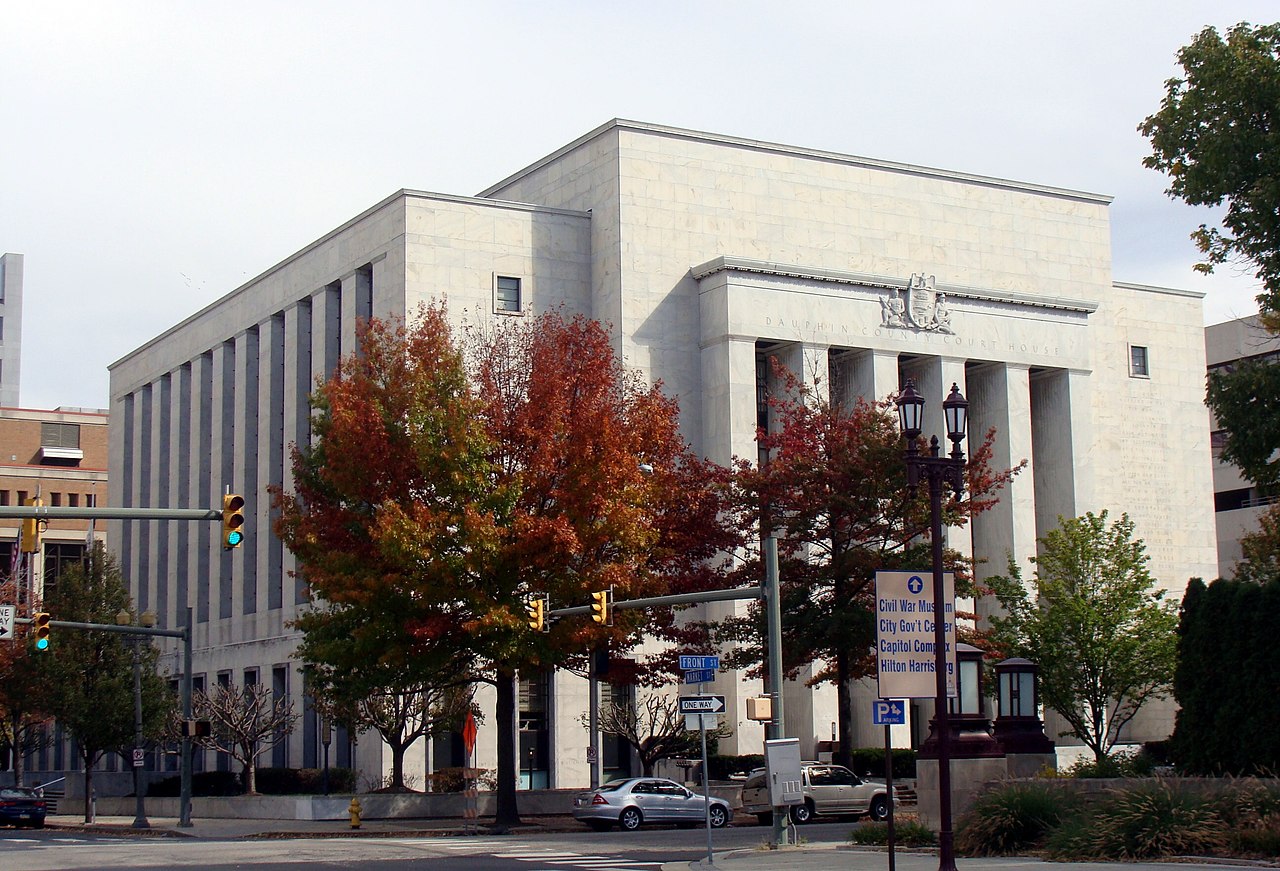
Dauphin County Government Complex, in downtown Harrisburg, serves the administrative functions of the county. The trial court of general jurisdiction for Harrisburg rests with the Court of Dauphin County and is largely funded and operated by county resources and employees.
The Pennsylvania State Capitol Complex dominates the city's stature as a regional and national hub for government and politics. All administrative functions of the Commonwealth of Pennsylvania are located within the complex and at various nearby locations.
The Commonwealth Judicial Center houses Pennsylvania's three appellate courts, which are located in Harrisburg. The Supreme Court of Pennsylvania, which is the court of last resort in the state, hears arguments in Harrisburg as well as Philadelphia and Pittsburgh. The Superior Court of Pennsylvania and the Commonwealth Court of Pennsylvania are located here. Judges for these courts are elected at large.
The Ronald Reagan Federal Building and Courthouse, located in downtown Harrisburg, serves as the regional administrative offices of the federal government. A branch of the U.S. District Court for the Middle District of Pennsylvania is also located within the courthouse. Due to Harrisburg's prominence as the state capital, federal offices for nearly every agency are located within the city.
The United States military has a strong historic presence in the region. A large retired military population resides in South Central Pennsylvania and the region is home to a large national cemetery at Indiantown Gap. The federal government, including the military, is the top employer in the metropolitan area.
Military bases in the Harrisburg area include:
Domestic and international airlines provide service via Harrisburg International Airport (MDT), which is located southeast of the city in Middletown. HIA is the third-busiest commercial airport in Pennsylvania, in terms of both passengers served and cargo shipments. Generally, due to the lack of an airline hub, the more popular airports in the region are Baltimore, Dulles, and Philadelphia. However, nearly 1.2 million people fly out of Harrisburg each year.[97] Passenger carriers that serve HIA include American Airlines, United Airlines, Delta Air Lines, Frontier Airlines, and Allegiant Air. Capital City Airport (CXY), a moderate-sized business class and general aviation airport, is located across the Susquehanna River in the nearby suburb of New Cumberland, south of Harrisburg. Both airports are owned and operated by the Susquehanna Area Regional Airport Authority (SARAA), which also manages the Franklin County Regional Airport in Chambersburg and Gettysburg Regional Airport in Gettysburg.
From the 1940s to 1960s, the Harrisburg Seaplane Base on the West Shore of the Susquehanna River facilitated the landing and docking of seaplanes in the river between the M. Harvey Taylor Memorial Bridge and the Walnut Street Bridge, until it was converted into a marina and boat dealership.[98]
Harrisburg is served by Capital Area Transit (CAT), which provides public bus and paratransit service throughout the greater metropolitan area. Construction of a commuter rail line designated the Capital Red Rose Corridor, previously named CorridorOne, was planned to link the city with nearby Lancaster until plans went dormant in 2011.[99][100]
Long-term plans for the region called for the commuter rail line to continue westward to Cumberland County, ending at Carlisle. In early 2005, the project hit a roadblock when the Cumberland County commissioners opposed the plan to extend commuter rail to the West Shore. Due to lack of support from the county commissioners, the Cumberland County portion, and the two new stations in Harrisburg have been removed from the project. In the future, with support from Cumberland County, the commuter rail project may extend to both shores of the Susquehanna River, where the majority of the commuting base for the Harrisburg–Carlisle metropolitan statistical area resides.[101]
In 2006, a second phase of the rail project designated CorridorTwo was announced to the general public. It was planned to link downtown Harrisburg with its eastern suburbs in Dauphin and Lebanon counties, including the areas of Hummelstown, Hershey and Lebanon, and the city of York in York County.[101] Other planned passenger rail corridors also included Route 15 from the Harrisburg area towards Gettysburg, as well as the Susquehanna River communities north of Harrisburg, and the Northern Susquehanna Valley region.[101]
The lower level of the Harrisburg Transportation Center serves as the city's intercity bus terminal. Daily bus services are provided by Greyhound, Capitol Trailways, and Fullington Trailways. They connect Harrisburg to other Pennsylvania cities such as Allentown, Philadelphia, Pittsburgh, Reading, Scranton, State College, Williamsport, and York and nearby, out-of-state cities such as Baltimore, Binghamton, New York, Syracuse, and Washington, D.C., plus many other destinations via transfers.[102]
Curbside intercity bus service is also provided by Megabus from the parking lot of the Harrisburg Mall in nearby Swatara Township, with direct service to Philadelphia, State College, and Pittsburgh.
The public transit provider in York County, Rabbit Transit, operates its RabbitEXPRESS bus service from York via Route 83N and from Gettysburg via Route 15N which serves both downtown Harrisburg and the main campus for Harrisburg Area Community College. The commuter-oriented service is designed to serve residents from these areas who work in Harrisburg, though reverse commutes are possible under the current schedule. Route 83N makes limited stops in the city of York and at two park and rides along Interstate 83 between York and Harrisburg before making multiple stops in Harrisburg, while Route 15N makes two stops in Gettysburg and at two park and rides along U.S. Route 15 between Gettysburg and Harrisburg before making multiple stops in Harrisburg.
Lebanon Transit operates the Commute King A and Commute King B express bus routes which connect Lebanon to Harrisburg via U.S. Route 422 and Interstate 81 respectively.
A charter/tour bus operator, R & J Transport, also provides weekday, scheduled route commuter service for people working in downtown Harrisburg. R & J, which is based in Schuylkill County, operates two lines, one between Frackville and downtown Harrisburg and the other between Minersville, Pine Grove, and downtown Harrisburg.
The Pennsylvania Railroad's main line from New York to Chicago passed through Harrisburg. The line was electrified in the 1930s, with the wires reaching Harrisburg in 1938. They went no further. Plans to electrify through to Pittsburgh and thence to Chicago never saw fruition; sufficient funding was never available. Thus, Harrisburg became where the PRR's crack expresses such as the Broadway Limited changed from electric traction to (originally) a steam locomotive, and later a diesel locomotive. Harrisburg remained a freight rail hub for PRR's successor Conrail, which was later sold off and divided between Norfolk Southern and CSX.
Norfolk Southern acquired all of Conrail's lines in the Harrisburg area and has continued the city's function as a freight rail hub. Norfolk Southern considers Harrisburg one of many primary hubs in its system, and operates two intermodal (rail/truck transfer) yards in the immediate Harrisburg area.[103] The Harrisburg Intermodal Yard (formerly called Lucknow Yard) is located approximately three miles north of downtown Harrisburg and the Harrisburg Transport Center, while the Rutherford Intermodal Yard is located approximately six miles east of downtown Harrisburg in Swatara Township, Dauphin County. Norfolk Southern also operates a significant classification yard in the Harrisburg area, the Enola Yard, which is located across the Susquehanna River from Harrisburg in East Pennsboro Township, Cumberland County.
Amtrak provides service to and from Harrisburg. The passenger rail operator runs its Keystone Service and Pennsylvanian routes between New York, Philadelphia, and the Harrisburg Transportation Center daily. The Pennsylvanian route, which operates once daily, continues west to Pittsburgh. As of April 2007, Amtrak operates 14 weekday roundtrips and 8 weekend roundtrips daily between Harrisburg, Lancaster, and 30th Street Station in Philadelphia; most of these trains also travel to and from New York Penn Station. The Keystone Corridor between Harrisburg and Philadelphia was improved in the mid-first decade of the 21st century, with the primary improvements completed in late 2006. The improvements included upgrading the electrical catenary, installing continuously welded rail, and replacing existing wooden railroad ties with concrete ties. These improvements increased train speeds to 110 mph along the corridor and reduced the travel time between Harrisburg and Philadelphia to as little as 95 minutes. It also eliminated the need to change locomotives at 30th Street Station from diesel to electric and vice versa for trains continuing to or coming from New York City.
As of 2008, the Harrisburg Transportation Center was the 2nd busiest Amtrak station in Pennsylvania and 21st busiest in the United States.[104][105]

Harrisburg is served by several major highways, including Interstate 76 (Pennsylvania Turnpike), which passes south of the city and accesses two interchanges, running west to Pittsburgh and east to Philadelphia. Interstate 81 passes to the north of Harrisburg and heads southwest toward Carlisle and northeast toward Hazleton. Interstate 83 begins at I-81 near Harrisburg and heads south and west through the center of Harrisburg before continuing south toward York and Baltimore. Interstate 283 connects I-76 and I-83 southeast of Harrisburg. U.S. Route 11 and U.S. Route 15 pass through the western suburbs of Harrisburg, heading north concurrent from Camp Hill up the west bank of the Susquehanna River toward Selinsgrove. South of Camp Hill, US 11 heads southwest toward Carlisle and US 15 heads south toward Gettysburg. U.S. Route 22 and U.S. Route 322 head northwest concurrent from Harrisburg toward Lewistown. US 22 passes through the northern portion of Harrisburg before it heads northeast toward Allentown. US 322 bypasses Harrisburg along I-81 and I-83 before heading east toward Hershey. Pennsylvania Route 230 heads south from US 22 in the northern part of Harrisburg and passes through the city along Cameron Street. Pennsylvania Route 283 heads southeast from I-283 on a freeway toward Lancaster. Pennsylvania Route 581 connects I-81 and I-83 on a freeway through the western suburbs of Harrisburg. I-81, I-83, and PA 581 form the Capital Beltway that circles Harrisburg.[106][107]
Harrisburg is the location of over a dozen large bridges, many up to a mile long, that cross the Susquehanna River. Several other important structures span the Paxton Creek watershed and Cameron Street, linking Downtown with neighborhoods in East Harrisburg. These include the State Street Bridge, also known as the Soldiers and Sailor's Memorial Bridge, and the Mulberry Street Bridge. Walnut Street Bridge, now used only by pedestrians and cyclists, links the downtown and Riverfront Park areas with City Island but goes no further as spans are missing on its western side due to massive flooding resulting from the North American blizzard of 1996.
Harrisburg is served by the Harrisburg School District. The school district provides education for the city's youth beginning with all-day kindergarten through twelfth grade. In 2003, SciTech High, a regional math and science magnet school affiliated with Harrisburg University, opened its doors to local students.
The city also has several public charter schools: Infinity Charter School, Sylvan Heights Science Charter School, Premier Arts and Science Charter School, and Capital Area School for the Arts.
The Central Dauphin School District, the largest public school district in the Harrisburg–Carlisle metropolitan statistical area and the 13th-largest in Pennsylvania, has several Harrisburg postal addresses for many of the District's schools. Steelton-Highspire School District borders much of the Harrisburg School District.
Harrisburg is home to an extensive Catholic educational system. There are nearly 40 parish-driven elementary schools and seven Catholic high schools within the region administered by the Roman Catholic Diocese of Harrisburg, including Bishop McDevitt High School and Trinity High School. Numerous other private schools, such as The Londonderry School and The Circle School, which is a Sudbury Model school, also operate in Harrisburg. Harrisburg Academy, founded in 1784, is one of the oldest independent college preparatory schools in the nation. The Rabbi David L. Silver Yeshiva Academy, founded in 1944, is a progressive, modern Jewish day school. Also, Harrisburg is home to Harrisburg Christian School, founded in 1955.[108]
Since the early 18th century, Harrisburg has been home to many people of note. Because it is the seat of government for the state and lies relatively close to other urban centers, Harrisburg has played a significant role in the nation's political, cultural and industrial history. "Harrisburgers" have also taken a leading role in the development of Pennsylvania's history for over two centuries. Two former U.S. Secretaries of War, Simon Cameron and Alexander Ramsey and several other prominent political figures, such as former speaker of the house Newt Gingrich, hail from Harrisburg. The actor Don Keefer was born near Harrisburg, along with the actor Richard Sanders, most famous for playing Les Nessman in WKRP in Cincinnati. Many notable individuals are interred at Harrisburg Cemetery and East Harrisburg Cemetery.
{{cite web}}: CS1 maint: unfit URL (link)