This is a list of some of the ways regions are defined in the United States . Many regions are defined in law or regulations by the federal government; others by shared culture and history, and others by economic factors.
Interstate regions
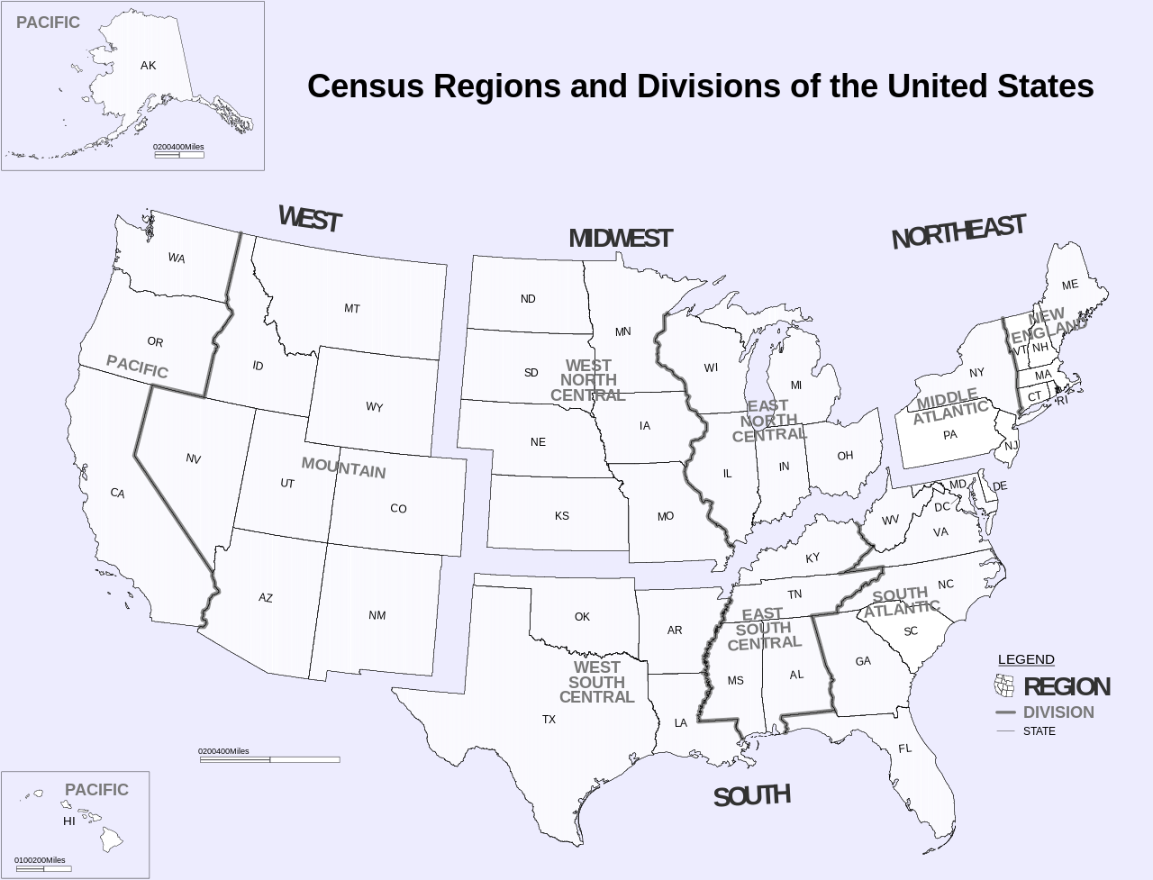
Census Bureau–designated regions and divisions U.S. Census Bureau regions and divisionsSince 1950, the United States Census Bureau defines four statistical regions, with nine divisions.[1] [2] The Census Bureau region definition is "widely used ... for data collection and analysis",[3] and is the most commonly used classification system.[4] [5] [6] [7]
Region 1: Northeast Region 2: Midwest (designated as the North Central Region before June 1984)[8] Division 3: East North Central (Illinois , Indiana , Michigan , Ohio, and Wisconsin ) Division 4: West North Central (Iowa, Kansas , Minnesota , Missouri , Nebraska , North Dakota , and South Dakota ) Region 3: South Division 5: South Atlantic (Delaware , Florida , Georgia , Maryland , North Carolina , South Carolina , Virginia , Washington, D.C. , and West Virginia ) Division 6: East South Central (Alabama , Kentucky , Mississippi , and Tennessee ) Division 7: West South Central (Arkansas , Louisiana , Oklahoma , and Texas ) Region 4: WestDivision 8: Mountain (Arizona , Colorado , Idaho , Montana , Nevada , New Mexico , Utah, and Wyoming ) Division 9: Pacific (Alaska , California , Hawaii , Oregon , and Washington ) Puerto Rico and other US territories are not part of any census region or census division.[9]
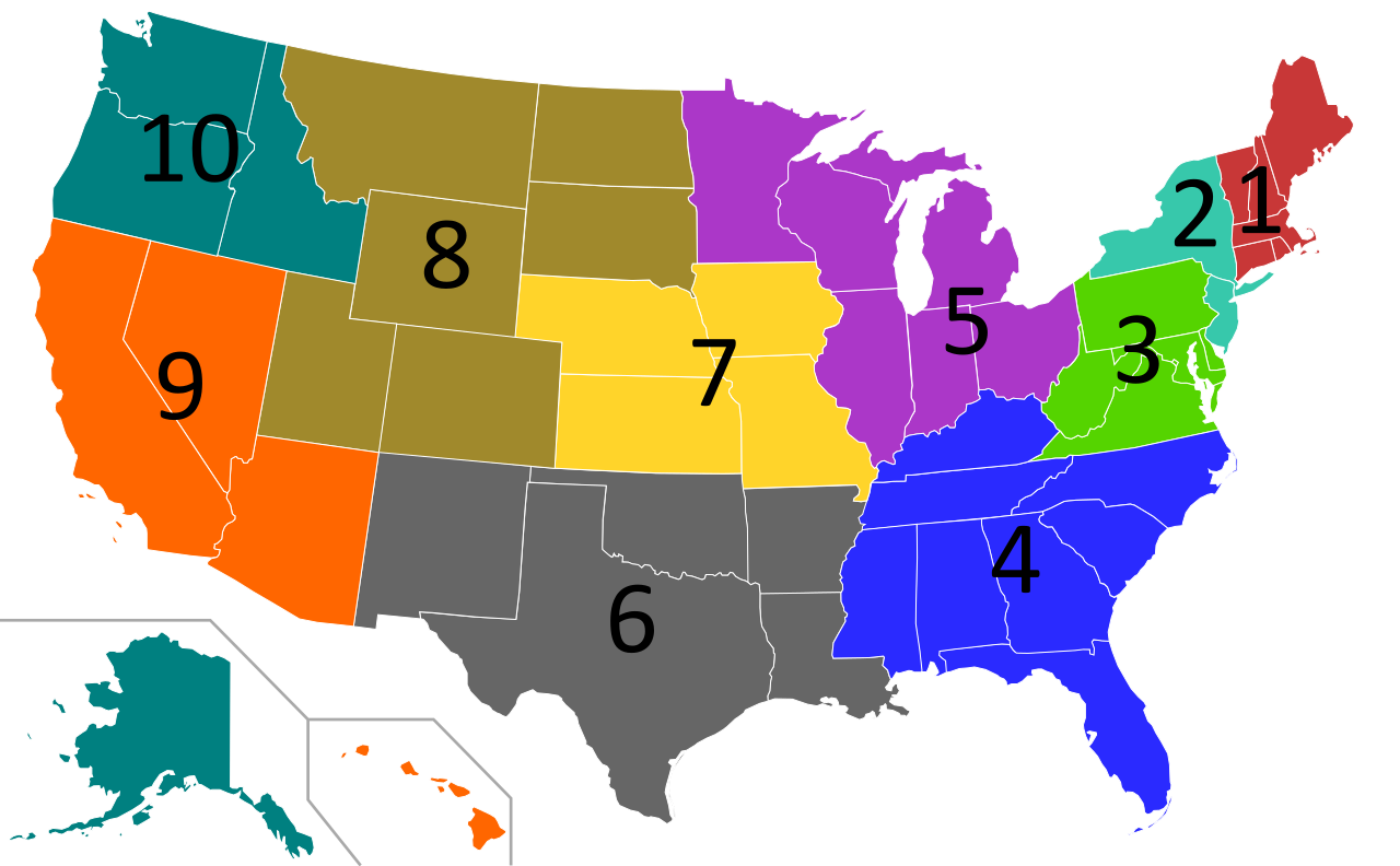
Federal Reserve Banks Federal Reserve System districtsThe Federal Reserve Act of 1913 divided the country into twelve districts with a central Federal Reserve Bank in each district. These twelve Federal Reserve Banks together form a major part of the Federal Reserve System , the central banking system of the United States. Missouri is the only U.S. state to have two Federal Reserve locations within its borders, but several other states are also divided between more than one district.
Boston New York Philadelphia Cleveland Richmond Atlanta Chicago St. Louis Minneapolis Kansas City Dallas San Francisco
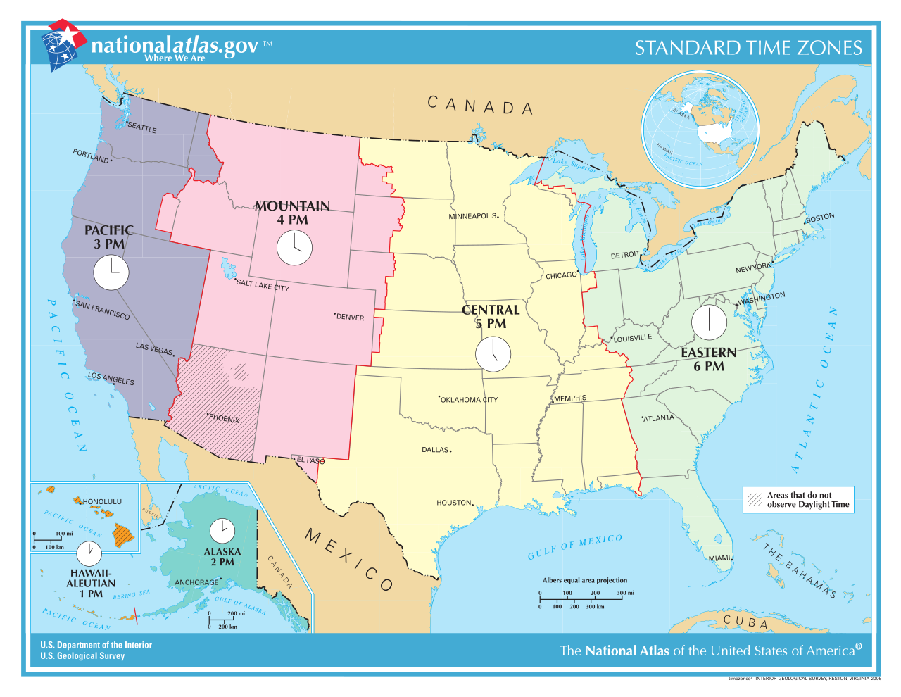
Time zones U.S. time zones (some U.S. time zones are not on this map) UTC−12:00 (Baker Island , Howland Island )Samoa Time Zone (American Samoa , Jarvis Island , Kingman Reef , Midway Atoll , Palmyra Atoll )Hawaii–Aleutian Time Zone (Hawaii , Aleutian Islands (Alaska) , Johnston Atoll )Alaska Time Zone (Alaska , excluding Aleutian Islands)Pacific Time Zone Arizona Time Zone (excluding the Navajo Nation )[10] Mountain Time Zone (excluding most parts of Arizona )Central Time Zone Eastern Time Zone Atlantic Time Zone (Puerto Rico , U.S. Virgin Islands )Chamorro Time Zone (Guam, Northern Mariana Islands )Wake Island Time Zone (Wake Island )
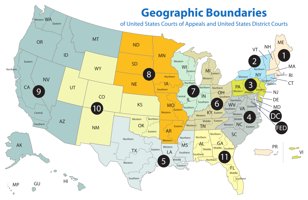
Courts of Appeals circuits U.S. Courts of Appeals circuitsThe Federal Circuit is not a regional circuit. Its jurisdiction is nationwide but based on the subject matter.
Agency administrative regions In 1969, the Office of Management and Budget published a list of ten "Standard Federal Regions",[11] to which federal agencies could be restructured as a means of standardizing government administration nationwide. Despite a finding in 1977 that this restructuring did not reduce administrative costs as initially expected,[12] and the complete rescinding of the standard region system in 1995,[13] several agencies continue to follow the system, including the Environmental Protection Agency [14] and the Department of Housing and Urban Development .[15]
Regions and office locations Regions of the U.S. Environmental Protection Agency
Region I Office location: Boston
States: Connecticut , Maine , Massachusetts , New Hampshire , Rhode Island , and Vermont
Region II Office location: New York City
States: New York , New Jersey , Puerto Rico , and the U.S. Virgin Islands
Region III Office location: Philadelphia
States: Delaware , Maryland , Pennsylvania , Virginia , Washington, D.C. , and West Virginia
Region IV Office location: Atlanta
States: Alabama , Florida , Georgia , Kentucky , Mississippi , North Carolina , South Carolina , and Tennessee
Region V Office location: Chicago
States: Illinois , Indiana , Minnesota , Michigan , Ohio, and Wisconsin
Region VI Office location: Dallas
States: Arkansas , Louisiana , New Mexico , Oklahoma , and Texas
Region VII Office location: Kansas City
States: Iowa, Kansas , Missouri , and Nebraska
Region VIII Office location: Denver
States: Colorado , Montana , North Dakota , South Dakota , Utah, and Wyoming
Region IX Office location: San Francisco
States: Arizona , California , Hawaii , Nevada , Guam, Northern Mariana Islands , and American Samoa
Region X Office location: Seattle
States: Alaska , Idaho , Oregon , and Washington
Bureau of Economic Analysis regions Bureau of Economic Analysis regionsThe Bureau of Economic Analysis defines regions for comparison of economic data.[16]
New England: Connecticut , Maine , Massachusetts , New Hampshire , Rhode Island , and Vermont Mideast: Delaware , Maryland , New Jersey , New York , Pennsylvania , and Washington, D.C. Great Lakes: Illinois , Indiana , Michigan , Ohio, and Wisconsin Plains: Iowa, Kansas , Minnesota , Missouri , Nebraska , North Dakota , and South Dakota Southeast: Alabama , Arkansas , Florida , Georgia , Kentucky , Louisiana , Mississippi , North Carolina , South Carolina , Tennessee , Virginia , and West Virginia Southwest: Arizona , New Mexico , Oklahoma , and Texas Rocky Mountain: Colorado , Idaho , Montana , Utah, and Wyoming Far West: Alaska , California , Hawaii , Nevada , Oregon , and Washington
Unofficial regions
Multi-state regions
Multi-territory regions
The Belts
Interstate megalopolises
Interstate metropolitan areas Central Savannah River Area (part of Georgia and South Carolina)Baltimore–Washington metropolitan area (Washington, D.C. and parts of Maryland, Virginia, West Virginia, and Pennsylvania)Greater Boston (parts of Massachusetts, Rhode Island, and New Hampshire)Charlotte metropolitan area (parts of North Carolina and South Carolina)Chattanooga Metropolitan Area Chicago metropolitan area (parts of Illinois, Indiana, and Wisconsin)Cincinnati metropolitan area (parts of Ohio, Indiana, and Kentucky)Columbus-Auburn-Opelika (GA-AL) Combined Statistical Area (parts of Georgia and Alabama)Delaware Valley (parts of Pennsylvania, New Jersey, Delaware, and Maryland)Evansville, IN–KY Metropolitan Statistical Area (parts of Indiana and Kentucky)Fargo–Moorhead (parts of North Dakota and Minnesota)Fort Smith metropolitan area (parts of Arkansas and Oklahoma)Front Range Urban Corridor (parts of Colorado and Wyoming)Greater Grand Forks (part of Minnesota and North Dakota)Hartford-Springfield (parts of Connecticut and Massachusetts)Kansas City metropolitan area (parts of Missouri and Kansas)Louisville metropolitan area (Kentuckiana) (parts of Kentucky and Indiana)Memphis metropolitan area (parts of Tennessee, Arkansas, and Mississippi)Michiana (parts of Michigan and Indiana)Minneapolis–Saint Paul (the Twin Cities) (parts of Minnesota and Wisconsin)New York metropolitan area (parts of New York, New Jersey, Connecticut, and Pennsylvania)Omaha–Council Bluffs metropolitan area (parts of Nebraska and Iowa)Portland metropolitan area (parts of Oregon and Washington)Quad Cities (parts of Iowa and Illinois)Sacramento metropolitan area (parts of California and Nevada)Greater St. Louis (parts of Missouri and Illinois)Texarkana metropolitan area (parts of Texas and Arkansas)Tri-Cities (parts of Tennessee and Virginia)Twin Ports (Duluth, Minnesota and Superior, Wisconsin )Hampton Roads region (parts of Virginia and North Carolina)Youngstown–Warren–Boardman metropolitan statistical area (parts of Ohio and Pennsylvania)
Intrastate and intraterritory regions
Alabama A map of regions of Alabama Regions of Alabama include:
Alaska Southeast Alaska , also known as the Alaska PanhandleRegions of Alaska include:
American Samoa American Samoa Regions of American Samoa include:
Arizona The Arizona Strip Regions of Arizona include:
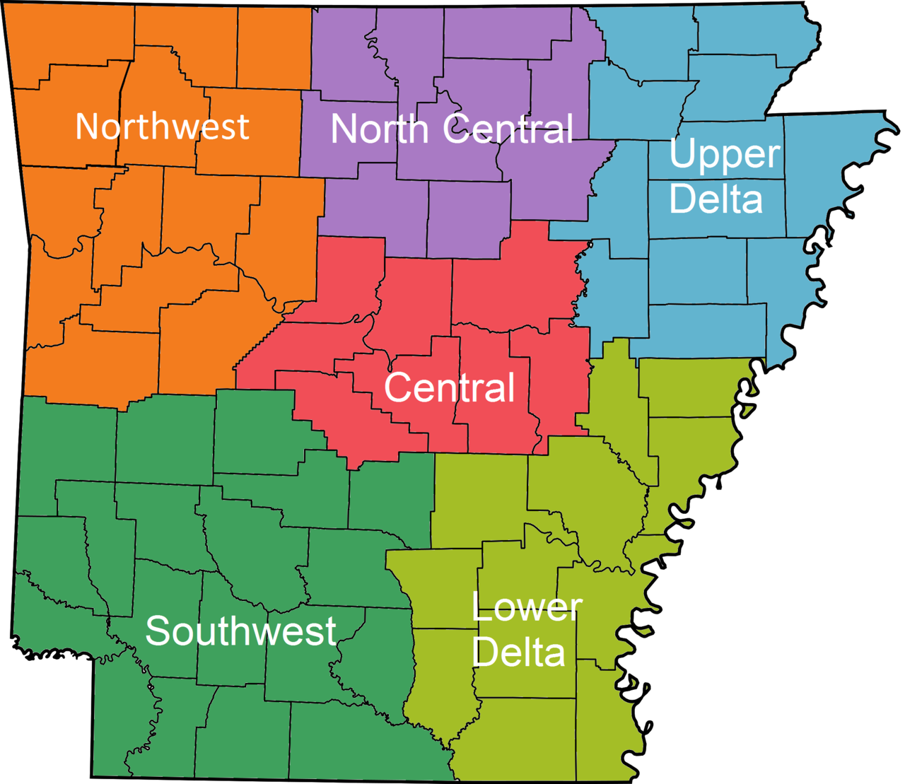
Arkansas Regions of Arkansas Regions of Arkansas include:
California
Colorado An enlargeable map of the Front Range Urban Corridor of Colorado and Wyoming Regions of Colorado include:
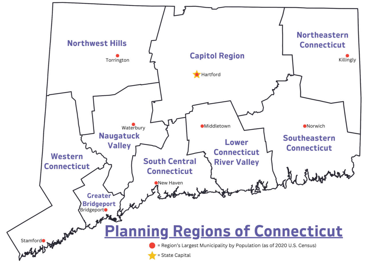
Connecticut Map highlighting the nine regions of Connecticut Connecticut has nine official planning regions, which operate as councils of governments and are recognized as county equivalents by the U.S. Census Bureau . The nine regions are:
Some of Connecticut's informal regions include:
Delaware The Delaware Valley , also known as metropolitan Philadelphia Regions of Delaware include:
"Slower Lower":
District of Columbia
Florida The First Coast The Florida Panhandle Directional regions of Florida include:
Local vernacular regions of Florida include:
Georgia Regions of Georgia include:
Physiographic regions Physiographic regions of Georgia include:
Guam Regions of Guam include:
Hawaii Hawaiian archipelago Hawaiian Islands Regions of Hawaii include:
Idaho The Idaho Panhandle Regions of Idaho include:
Illinois Southern Illinois , also known as "Little Egypt"Regions of Illinois include:
Indiana Regions of Indiana Regions of Indiana include:
Iowa Regions of Iowa Regions of Iowa include:
Kansas Regions of Kansas include:
Kentucky Regions of Kentucky include:
Louisiana Regions of Louisiana Regions of Louisiana include:
Maine Regions of Maine include:
Maryland Regions of Maryland Regions of Maryland include:
Regions of Maryland shared with other states include:
Massachusetts The Berkshires region of Massachusetts Regions of Massachusetts include:
Michigan Regions of Michigan Regions of Michigan include:
Lower Peninsula
Upper Peninsula
Minnesota Regions of Minnesota Regions of Minnesota include:
Mississippi Regions of Mississippi include:
Missouri The Missouri Bootheel Regions of Missouri include:
Montana Regions of Montana include:
Nebraska The Nebraska Panhandle Regions of Nebraska include:
Nevada Regions of Nevada include:
New Hampshire Regions of New Hampshire include:
New Jersey Regions of New Jersey include:
New Mexico Regions of New Mexico include:
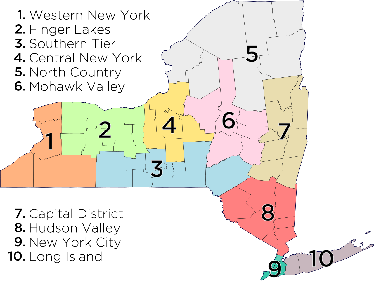
New York Regions of New York states as defined by the Empire State Development Corporation Regions of New York The ten regions of New York , as defined by the Empire State Development Corporation :
Capital District – counties : Albany , Columbia , Greene , Warren , Washington , Saratoga , Schenectady , Rensselaer Central New York – counties: Cortland , Cayuga , Onondaga , Oswego , Madison Finger Lakes – counties: Orleans , Genesee , Wyoming , Monroe , Livingston , Wayne , Ontario , Yates , Seneca Hudson Valley – counties: Sullivan , Ulster , Dutchess , Orange , Putnam , Rockland , Westchester Long Island – counties: Nassau , Suffolk Mohawk Valley – counties: Oneida , Herkimer , Fulton , Montgomery , Otsego , Schoharie New York City – counties (boroughs): New York (Manhattan ), Bronx (The Bronx ), Queens (Queens ), Kings (Brooklyn ), Richmond (Staten Island ) North Country – counties : St. Lawrence , Lewis , Jefferson , Hamilton , Essex , Clinton , Franklin Southern Tier – counties: Steuben , Schuyler , Chemung , Tompkins , Tioga , Chenango , Broome , Delaware Western New York – counties: Niagara , Erie, Chautauqua , Cattaraugus , Allegany Regions of New York state include:
North Carolina Regions of North Carolina Regions of North Carolina include:
North Dakota Regions of North Dakota include:
Northern Mariana Islands Northern Mariana Islands Regions of the Northern Mariana Islands include:
Ohio The Great Black Swamp region of Ohio Regions of Ohio include:
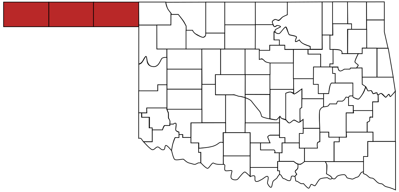
Oklahoma The Oklahoma Panhandle Regions of Oklahoma include:
Oregon The topography of Oregon Oregon's High Desert Regions of Oregon include:
Pennsylvania Regions of Pennsylvania include:
Puerto Rico Puerto Rico Regions of Puerto Rico include:
Rhode Island Regions of Rhode Island include:
South Carolina Regions of South Carolina include:
Other geographical distinctions:
South Dakota East River and West River in South Dakota Regions of South Dakota include:
Tennessee The Grand Divisions of Tennessee include:
Texas The Texas Panhandle Regions of Texas include:
U.S. Minor Outlying Islands The United States Minor Outlying Islands (Navassa Island not on map) Regions of United States Minor Outlying Islands include:
U.S. Virgin Islands Regions of United States Virgin Islands include:
Utah Regions of Utah include:
Vermont Regions of Vermont include:
Virginia A map of the Shenandoah Valley region of Virginia Regions of Virginia include:
Washington Regions of Washington include:
West Virginia Regions of West Virginia include:
Wisconsin Wisconsin 's five geographic regionsWisconsin is divided into five geographic regions :
Wyoming Regions of Wyoming include:
See also
Explanatory notes
References ^ "Statistical Groupings of States and Counties" (PDF) . census.gov . United States Census Bureau. Retrieved December 16, 2020 . ^ United States Census Bureau, Geography Division. "Census Regions and Divisions of the United States" (PDF) . Retrieved January 10, 2013 . ^ "The National Energy Modeling System: An Overview 2003" (Report #: DOE/EIA-0581, October 2009). United States Department of Energy, Energy Information Administration . ^ "The most widely used regional definitions and follow those of the U.S. Bureau of the Census." Seymour Sudman and Norman M. Bradburn, Asking Questions: A Practical Guide to Questionnaire Design (1982). Jossey-Bass : p. 205. ^ "Perhaps the most widely used regional classification system is one developed by the U.S. Census Bureau." Dale M. Lewison, Retailing , Prentice Hall (1997): p. 384. ISBN 978-0-13-461427-4 ^ "[M]ost demographic and food consumption data are presented in this four-region format." Pamela Goyan Kittler, Kathryn P. Sucher, Food and Culture , Cengage Learning (2008): p.475. ISBN 9780495115410 ^ "Census Bureau Regions and Divisions with State FIPS Codes" (PDF) . US Census Bureau. Archived from the original (PDF) on September 21, 2013. Retrieved June 20, 2010 . ^ "Census Bureau Regions and Divisions with State FIPS Codes" (PDF) . US Census Bureau. Archived from the original (PDF) on September 21, 2013. Retrieved June 20, 2010 . ^ "Geographic Terms and Concepts - Census Divisions and Census Regions". US Census Bureau. Retrieved August 19, 2015 . ^ "No DST in Most of Arizona". www.timeanddate.com . Retrieved August 14, 2020 . ^ Standard Federal Regions , Office of Management and Budget , 1969, Circular A-105^ Office of Management and Budget (August 17, 1977), Standardized Federal Regions: Little Effect on Agency Management of Personnel, Government Accountability Office , FPCD-77-39^ 60 FR 15171 ^ Williams, Dennis C. (March 1993), Why Are Our Regional Offices and Labs Located Where They Are? A Historical Perspective on Siting, U.S. Environmental Protection Agency ^ HUD's Regions, U.S. Department of Housing and Urban Development , September 20, 2017 ^ "BEA Regions". Bureau of Economic Analysis. February 18, 2004. Retrieved December 27, 2012 . ^ The World Factbook CIA World Factbook - American Samoa. Retrieved July 5, 2019.
External links U.S. Library of Congress Map of the US Regions


.png/1280px-Rico_(1).png)


