Великие равнины — обширные равнины в Северной Америке . Регион расположен к востоку от Скалистых гор , большая его часть покрыта прериями , степями и лугами . Они являются западной частью Внутренних равнин , которые включают смешанные прерии , высокотравные прерии между Великими озерами и Аппалачским плато , а также экозоны Таежных равнин и Бореальных равнин в Северной Канаде . «Великие равнины», или Западные равнины , также являются экорегионом Великих равнин или, альтернативно, западной частью Великих равнин.
Великие равнины расположены как в центральной части США , так и в Западной Канаде и охватывают:

Термин «Великие равнины» используется в Соединенных Штатах для описания подсекции еще более обширного физико-географического подразделения Внутренних равнин , которое охватывает большую часть внутренней части Северной Америки. Он также имеет значение как регион человеческой географии , относящийся к индейцам равнин или штатам равнин . [ необходима цитата ]
В Канаде этот термин используется редко; Министерство природных ресурсов Канады , правительственный департамент, ответственный за официальное картографирование, рассматривает Внутренние равнины как единое целое, состоящее из нескольких связанных плато и равнин. В Атласе Канады нет региона, называемого «Великие равнины» . [2] С точки зрения географии человека термин «прерия » чаще используется в Канаде, и этот регион известен как Канадские прерии , провинции прерий или просто «Прерии». [ требуется ссылка ]
Североамериканский экологический атлас , подготовленный Комиссией по экологическому сотрудничеству , агентством Североамериканского соглашения о свободной торговле (НАФТА), состоящим из географических агентств правительств Мексики, Америки и Канады, использует «Великие равнины» как экорегион , синонимичный преобладающим прериям и лугам, а не как физиографический регион, определяемый топографией. [3] Экорегион Великих равнин включает пять субрегионов: умеренные прерии, западно-центральные полузасушливые прерии, южно-центральные полузасушливые прерии, прибрежные равнины Техаса и Луизианы и полузасушливая равнина Тамаулипас-Техас, которые частично совпадают или расширяют другие обозначения Великих равнин. [4]
.jpg/1280px-On_the_Great_Plains,_Kansas,_294_miles_west_of_Missouri_River._(redo_2016).jpg)
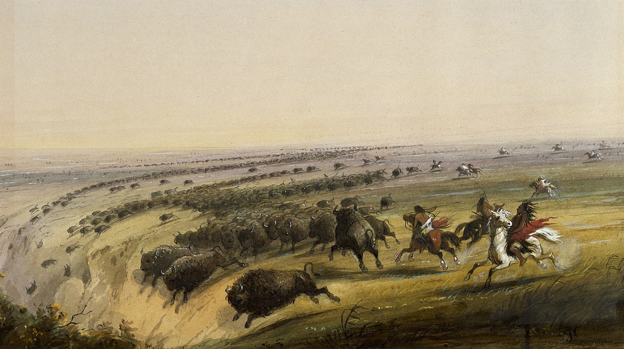
Регион простирается примерно на 500 миль (800 км) с востока на запад и на 2000 миль (3200 км) с севера на юг. Большая часть региона была домом для американских бизонов , пока они не были истреблены до почти полного вымирания в середине/конце 19-го века. Его площадь составляет приблизительно 500 000 кв. миль (1 300 000 км 2 ). Текущие взгляды относительно географических границ Великих равнин показаны на этой карте в Центре исследований Великих равнин, Университет Небраски-Линкольна . [1] Это определение, однако, в первую очередь является экологическим, а не физико-географическим. Бореальные равнины Западной Канады физико-географически одинаковы, но различаются своим видом тундры и леса (а не луга).
Термин «Великие равнины» для региона к западу от 96-го меридиана к западу и к востоку от Скалистых гор не использовался до начала 20-го века. Исследование Невина Феннемана 1916 года «Физиографическое подразделение Соединенных Штатов» [5] сделало термин «Великие равнины» более широко используемым. До этого регион почти неизменно назывался Высокими равнинами, в отличие от нижних равнин прерий в штатах Среднего Запада . [6] Сегодня термин « Высокие равнины » используется для субрегиона Великих равнин. [7] Этот термин по-прежнему остается малоупотребительным в Канаде по сравнению с более распространенным «прерией».
.jpg/1280px-Corn_Fields,_Iowa_Farm_7-13_(15277889101).jpg)

Великие равнины являются самой западной частью обширных североамериканских внутренних равнин , которые простираются на восток до Аппалачского плато . Геологическая служба США делит Великие равнины в Соединенных Штатах на десять физико-географических подразделений:
К этому можно добавить канадские физико-географические субрегионы, такие как Альбертская равнина, Кипарисовые холмы , Манитобский уступ (на востоке), Манитобская равнина, Миссурийское побережье (общее), предгорья Скалистых гор (на востоке) и Саскачеванская равнина. [8]
Великие равнины представляют собой широкую полосу страны, подстилаемую почти горизонтальными пластами, простирающимися на запад от 97-го меридиана на запад до подножия Скалистых гор , на расстояние от 300 до 500 миль (от 480 до 800 км). Они простираются на север от мексиканской границы далеко в Канаду. Хотя высота равнин постепенно увеличивается от 600 футов (180 м) или 1200 футов (370 м) на востоке до 4000–5000 футов (1200–1500 м) или 6000 футов (1800 м) вблизи гор, местный рельеф, как правило, невелик. Полузасушливый климат исключает рост деревьев и открывает далеко простирающиеся виды. [9]
Равнины ни в коем случае не являются простым образованием. Они имеют разнообразную структуру и находятся на разных стадиях эрозионного развития. Иногда они прерываются холмами и уступами . Они часто прерываются долинами. Однако в целом широко распространенная поверхность умеренного рельефа так часто преобладает, что название «Великие равнины» для всего региона вполне заслужено. [9]
Западная граница равнин обычно четко определена резким подъемом гор. Восточная граница равнин (в Соединенных Штатах) является скорее климатической, чем топографической . Линия 20 дюймов (510 мм) годового количества осадков проходит немного восточнее севернее около 97-го меридиана. Если необходимо провести границу там, где природа представляет собой только постепенный переход, эта линия осадков может быть принята для разделения более сухих равнин от более влажных прерий. [9] Однако в Канаде восточная граница равнин четко определена наличием Канадского щита на северо-востоке.
Равнины (в пределах Соединенных Штатов) можно описать как северные, промежуточные, центральные и южные секции в зависимости от определенных особенностей. [9] В Канаде такое разделение не используется: климатические и растительные регионы оказывают большее влияние на человеческое поселение, чем просто топография, и поэтому регион делится на (с севера на юг) таежные равнины , бореальные равнины , осиновые парки и прерийные экорегионы .
.jpg/1280px-Plains_Bison_Buffalo_(14958327875).jpg)

Северная часть Великих равнин, к северу от широты 44° , включает восточную Монтану , восточный Вайоминг , большую часть Северной Дакоты и Южной Дакоты , юго-западную Миннесоту и части канадских провинций, включая юго-восточную Альберту , южный Саскачеван и юго-западную Манитобу . Слои здесь меловые или раннетретичные , лежат почти горизонтально. Поверхность показана как равнина деградации с постепенным подъемом здесь и там к гребню неровного уступа, уступа-остатка стойкого слоя. Также есть случайные покрытые лавой столовые горы и дайковые хребты, возвышающиеся над общим уровнем на 500 футов (150 м) или более и явно демонстрирующие широко распространенную эрозию окружающих равнин. Все эти рельефы более многочисленны по направлению к горам в центральной Монтане. Пенеплен больше не находится в цикле эрозии, который был свидетелем его образования. Похоже, что он претерпел региональное поднятие или увеличение высоты, поскольку верхняя река Миссури и ее рукава больше не текут по поверхности равнины, а текут в хорошо выровненных, зрелых открытых долинах, на несколько сотен футов ниже общего уровня. Однако существенное исключение из правила зрелых долин происходит в случае Миссури, самой большой реки, которая разбита несколькими водопадами на твердых песчаниках примерно в 50 милях (80 км) к востоку от гор. Эта своеобразная особенность объясняется как результат смещения реки из более выровненной доледниковой долины плейстоценовым ледниковым щитом . Здесь ледниковый щит распространился по равнинам с умеренно возвышенных канадских нагорий далеко на северо-востоке, а не с гораздо более высоких гор поблизости на западе. Современная высота равнин у подножия горы составляет 4000 футов (1200 м). [9]
Северные равнины прерываются несколькими небольшими горными районами. Черные холмы, в основном на западе Южной Дакоты, являются самой большой группой. Они возвышаются как большой остров из моря, занимая овальную область около 100 миль (160 км) с севера на юг на 50 миль (80 км) с востока на запад. На пике Блэк-Элк они достигают высоты 7216 футов (2199 м) и имеют эффективный рельеф над равнинами 2000 или 3000 футов (610 или 910 м). Этот горный массив имеет плоскую сводчатую, куполообразную структуру, в настоящее время хорошо рассеченную расходящимися последовательными потоками. Более слабые верхние слои были размыты до уровня равнин, где их приподнятые края равномерно усечены. Следующие более твердые слои были достаточно размыты, чтобы раскрыть ядро нижележащих магматических и метаморфических кристаллических пород примерно в половине куполообразной области. [9]
В промежуточной части равнин, между широтами 44° и 42° , включая южную часть Южной Дакоты и северную часть Небраски , эрозия некоторых крупных районов особенно сложна. Известные как Бесплодные земли , они представляют собой тщательно расчлененную форму с рельефом в несколько сотен футов. Это происходит по нескольким причинам:

Центральная часть Великих равнин, между широтами 42° и 36° , занимающая восточную часть Колорадо и западную часть Канзаса , в основном представляет собой расчлененную речную равнину. То есть эта часть когда-то была гладко покрыта пологой равниной из гравия и песка, которая была распространена далеко вперед на широкой оголенной территории в качестве предгорного отложения реками, которые вытекали из гор. С тех пор она была более или менее расчленена эрозией долин. Таким образом, центральная часть равнин представляет собой резкий контраст с северной частью.
В то время как северная часть обязана своей гладкостью удалению местных гравийных и песков с ранее неровной поверхности под воздействием деградирующих рек и их впадающих притоков, южная часть обязана своей гладкостью отложению импортных гравийных и песков на ранее неровной поверхности под воздействием намывных рек и их исходящих рукавов. Эти две части также похожи тем, что остаточные возвышенности все еще здесь и там возвышаются над пенепленом северной части, в то время как речная равнина центральной части полностью погребла существовавший ранее рельеф. Исключение из этого утверждения должно быть сделано для юго-запада, близко к горам в южном Колорадо, где некоторые покрытые лавой столовые горы ( Меса-де-Майя , Ратон-Меса ) возвышаются на несколько тысяч футов над общим уровнем равнины и, таким образом, свидетельствуют о широко распространенной эрозии этого региона до того, как он был намыт. [9]


Южная часть Великих равнин, между широтами 35,5° и 25,5°, лежит в западном Техасе , восточном Нью-Мексико и западной Оклахоме . Как и центральная часть, она по большей части представляет собой расчлененную речную равнину. Однако низины, которые окружают ее со всех сторон, придают ей такой сильный рельеф, что она возвышается как плоскогорье, известное со времен мексиканской оккупации как Льяно- Эстакадо . Она имеет размеры примерно 150 миль (240 км) с востока на запад и 400 миль (640 км) с севера на юг. Она имеет очень неровные очертания, сужаясь к югу. Ее высота составляет 5500 футов (1700 м) в самой высокой западной точке, ближайшей к горам, откуда поставлялся ее гравий. Оттуда он наклоняется на юго-восток с уменьшающейся скоростью, сначала около 12 футов (3,7 м), затем около 7 футов/миль (1,3 м/км), к своим восточным и южным границам, где он достигает высоты 2000 футов (610 м). Как и Высокие равнины дальше на севере, он необычайно гладкий. [9]
Он очень сухой, за исключением редких неглубоких и временных водных пластов после дождей. Льяно отделен от равнин на севере зрелой последовательной долиной реки Канадиан , а от гор на западе — широкой и, вероятно, зрелой долиной реки Пекос . На востоке он сильно подрезан регрессивной эрозией верховьев рек Ред, Бразос и Колорадо в Техасе и представляет собой неровный уступ высотой примерно от 500 до 800 футов (от 150 до 240 м), возвышающийся над центральной оголенной областью этого штата. Там, между реками Бразос и Колорадо, находится ряд изолированных останцев, увенчанных известняком, который лежит под поднятием Льяно на западе и уступом Гранд-Прери на востоке. Южная и узкая часть плато, называемая плато Эдвардса , более расчленена, чем остальная часть, и обрывается на юг в виде изломанного уступа сброса. Этот уступ возвышается над прибрежной равниной залива Рио-Гранде . Центральная обнаженная область, к востоку от Льяно, напоминает восточно-центральную часть равнины, обнажая более старые породы. Между этими двумя похожими областями, в пространстве, ограниченном реками Канадиан и Ред-Ривер, возвышаются приглушенные формы гор Уичита в Оклахоме , самого западного члена системы Уошито. [9]
Термин «Западные равнины» используется для описания экорегиона Великих равнин [10] [11] или, альтернативно, западной части Великих равнин. [12]

В целом, Великие равнины имеют широкий диапазон погоды, с очень холодными и суровыми зимами и очень жарким и влажным летом. Скорость ветра часто очень высока, особенно зимой.
100-й меридиан примерно соответствует линии, которая делит Великие равнины на область, которая получает 20 дюймов (510 мм) или более осадков в год, и область, которая получает менее 20 дюймов (510 мм). В этом контексте Высокие равнины, а также Южная Альберта , юго-западный Саскачеван и Восточная Монтана в основном представляют собой полузасушливые степные земли и, как правило, характеризуются пастбищами или маргинальными сельскохозяйственными угодьями . Регион (особенно Высокие равнины) периодически подвергается продолжительным периодам засухи ; сильные ветры в регионе могут затем вызывать разрушительные пыльные бури . Восточная часть Великих равнин вблизи восточной границы попадает в зону влажного субтропического климата в южных районах, а северные и центральные районы попадают в зону влажного континентального климата .
Много гроз происходит на равнинах весной и летом. Юго-восточная часть Великих равнин является наиболее торнадо- активной зоной в мире и иногда ее называют Аллеей торнадо .
Великие равнины являются частью флористической провинции североамериканских прерий , которая простирается от Скалистых гор до Аппалачей . [13]
Хотя американские бизоны ( Bison bison ) исторически обитали на большей части территории Северной Америки (от Нью-Йорка до Орегона и от Канады до северной Мексики), они тесно связаны с Великими равнинами, где когда-то бродили огромными стадами. Вилорогие антилопы ( Antilocapra americana ) обитают в западных районах региона. Чернохвостая луговая собачка ( Cynomys ludovicianus ) является еще одним знаковым видом среди нескольких грызунов, которые связаны с регионом, включая тринадцатиполосого суслика ( Ictidomys tridecemlineatus ), пятнистого суслика ( Xerospermophilus spilosoma ), суслика Франклина ( Poliocitellus franklinii ), равнинного карманного суслика ( Geomys bursarius ), индийскую карманную мышь ( Chaetodipus hispidus ), оливковоспинную карманную мышь ( Perognathus fasciatus ), равнинную карманную мышь ( Perognathus flavescens ) и равнинную полевку ( Reithrodontomys montanus ). Два плотоядных, связанных с Великими равнинами, включают лисицу-стригуна ( Vulpes velox ) и находящегося под угрозой исчезновения черноногого хорька ( Mustela nigripes ). [14]
Малый луговой тетерев ( Tympanuchus pallidicinctus ) является эндемиком Великих равнин, а распространение большого лугового тетерева ( Tympanuchus cupido ) преимущественно происходит в этом регионе, хотя последний исторически распространялся дальше на восток. Воробей Харриса ( Zonotrichia querula ) проводит зимние месяцы в южных районах региона. Другие виды мигрируют с юга весной и проводят свой сезон размножения на равнинах, в том числе белолицый ибис ( Plegadis chihi ), горная ржанка ( Charadrius montanus ), мраморный веретенник ( Limosa fedoa ), конек Спрага ( Anthus spragueii ), воробей Кассина ( Peucaea cassinii ), воробей Бэрда ( Centronyx bairdii ), овсянка-жаворонок ( Calamospiza melanocorys ), каштановый ошейниковый длинношпорник ( Calcarius ornatus ), толстоклювый длинношпорник или длинношпорник Маккауна ( Rhynchophanes mccownii ) и клювохвост ( Spiza americana ). [15]
Гремучая змея прерий ( Crotalus viridis ) распространена на большей части Великих равнин, в долинах и нижних возвышенностях восточных Скалистых гор и в частях американского юго-запада . Другие змеи включают равнинную свиноносую змею ( Heterodon nasicus ), западную молочную змею ( Lampropeltis gentilis ), большую равнинную крысиную змею ( Pantherophis emoryi ), бычью змею ( Pituophis catenifer sayi ), равнинную черноголовую змею ( Tantilla nigriceps ), равнинную подвязочную змею ( Thamnophis radix ) и полосатую змею ( Tropidoclonion lineatum ). Разнообразие рептилий значительно увеличивается в южных регионах Великих равнин. В южных районах встречаются украшенная коробчатая черепаха ( Terrapene ornata ) и большой равнинный сцинк ( Plestiodon obsoletus ). [16]
Хотя немногие саламандры тесно связаны с регионом, западная тигровая саламандра ( Ambystoma mavortium ) встречается на большей части Великих равнин и Скалистых гор, как и жаба Скалистых гор ( Anaxyrus w. woodhousi ). Другие бесхвостые амфибии , связанные с регионом, включают жабу Великих равнин ( Anaxyrus cognatus ), равнинную леопардовую лягушку ( Lithobates blairi ) и равнинную лопатоногую жабу ( Spea bombifrons ). [16] [17]
Некоторые виды, преимущественно связанные с различными речными бассейнами Великих равнин, включают осетрового голавля ( Macrhybopsis gelida ), перечного голавля ( Macrhybopsis tetranema ), прерийного голавля ( Macrhybopsis australis ), западного серебристого гольяна ( Hybognathus argyritis ), равнинного гольяна ( Hybognathus placitus ), малоглазого чистика ( Notropis buccula ), арканзасского чистика ( Notropis girardi ), красного чистого чистика ( Notropis bairdi ) , топикского чистика ( Notropis topeka ), равнинного гольяна ( Fundulus sciadicus ), равнинного киллифиша ( Fundulus zebrinus ), красного чистого чистого чистика ( Cyprinodon rubrofluviatilis ) и арканзасского змеешейку ( Etheostoma cragini ). [18] [19]
На Великих равнинах также обитает множество видов беспозвоночных , как живых, так и вымерших, таких как американский могильщик (Nicrophorus americus), тигровый жук Солт-Крик (Cinidela nevadica lincolniana), гигантский тигровый жук Великих равнин (Amblycheila chylindriformis), Microstylum morosum [20] , бобовый листоед (Cerotoma trifurcata), верблюжий сверчок Великих равнин (Daihinia brevipes) [21] и мокрица Великих равнин (Lepyronia gibbosa). [22] [23] Некоторые виды на Великих равнинах вымерли, например, саранча Скалистых гор (Melanoplus spretus). [24]
_(15545351982).jpg/1280px-Daemonelix_burrows_(Harrison_Formation,_Middle_Miocene;_Agate_Fossil_Beds_National_Monument,_northwestern_Nebraska,_USA)_(15545351982).jpg)
В меловой период (145–66 миллионов лет назад) Великие равнины были покрыты неглубоким внутренним морем, называемым Западным внутренним морем . Однако в период с позднего мела до палеоцена (65–55 миллионов лет назад) море начало отступать, оставляя после себя толстые морские отложения и относительно ровную местность, которую море когда-то занимало. [25]
В кайнозойскую эру , а именно около 25 миллионов лет назад в эпоху миоцена и плиоцена , континентальный климат стал благоприятным для развития лугов. Существующие лесные биомы пришли в упадок, а луга стали гораздо более распространенными. Луга предоставили новую нишу для млекопитающих, включая многих копытных и глиров , которые перешли от поедания трав на выпас. Традиционно распространение лугов и развитие травоядных были тесно связаны. Однако исследование зубов млекопитающих показывает, что именно открытая, песчаная среда обитания, а не сама трава, связана с изменениями в рационе питания млекопитающих, что привело к появлению гипотезы « гравий, а не трава ». [26]
Палеонтологические находки в этом районе дали кости мамонтов , саблезубых кошек и других древних животных, [27] а также десятки других мегафауны (крупные животные весом более 100 фунтов [45 кг]) – такие как гигантские ленивцы , лошади , мастодонты и американские львы – которые доминировали на территории древних Великих равнин в течение тысяч или миллионов лет. Подавляющее большинство этих животных вымерло в Северной Америке в конце плейстоцена ( около 13 000 лет назад). [28]
На Великих равнинах расположено несколько значительных мест находок ископаемых, в том числе национальный памятник Агатовые окаменелости ( штат Небраска ), окаменелости Эшфолл ( штат Небраска ), государственный парк Клейтон-Лейк ( штат Нью-Мексико ), государственный парк Долина динозавров ( штат Техас ), место убийства бизонов Хадсон-Мэн (штат Небраска), государственный парк Макошика (штат Монтана) и место находок Мамонта ( штат Южная Дакота ).
.jpg/1280px-Scotts_Bluff_National_Monument_-_Nebraska_(14417716146).jpg)
Государственные и охраняемые земли на Великих равнинах включают национальные парки и национальные памятники, которыми управляет Служба национальных парков , отвечающая за сохранение экологических и исторических мест и предоставление их общественности. [29] Служба охраны рыбных ресурсов и диких животных США управляет национальными заповедниками, неся основную ответственность за сохранение и защиту рыб, диких животных, растений и среды обитания в общественном доверительном управлении. [30] Оба являются агентствами Министерства внутренних дел .
Напротив, Лесная служба США , агентство Министерства сельского хозяйства США , управляет Национальными лесами и Национальными пастбищами в рамках концепции многоцелевого использования. По закону Лесная служба США должна учитывать все ресурсы, не акцентируя внимание ни на одном ресурсе в ущерб другим, включая воду, почву, выпас скота, заготовку древесины и полезные ископаемые (горнодобывающая промышленность и бурение), а также рекреацию и сохранение рыб и диких животных. [31] Каждый отдельный штат также управляет государственными землями, как правило, меньшими по площади, для различных целей, включая сохранение и рекреацию.
Пастбища относятся к наименее защищенным биомам. [32] Люди переделали большую часть прерий в сельскохозяйственные цели или для создания пастбищ. Несколько охраняемых земель в регионе сосредоточены вокруг аномальных и нетипичных особенностей региона, таких как горы, обнажения и каньоны (например, Национальный памятник Башня Дьявола , Национальный парк Уинд-Кейв , Национальный памятник Скоттс-Блафф ), и какими бы великолепными и достойными они ни были, они не в первую очередь сосредоточены на сохранении равнин и прерий.
Соединенные Штаты:
Канада:
Биом Великих равнин находится на грани коллапса из-за вторжения древесных растений , при этом на сегодняшний день утрачено 62% североамериканских лугов. [33] [34]

Первые народы ( палеоиндейцы ) прибыли на Великие равнины тысячи лет назад. [35] [36] Появление кукурузы около 800 г. н. э. позволило развиться культуре строительства курганов в Миссисипи вдоль рек, пересекавших Великие равнины, и которая включала торговые сети на запад до Скалистых гор. [37] [38] Жители Миссисипи заселили Великие равнины в местах, которые сейчас находятся в Оклахоме и Южной Дакоте .
Носители языка сиу , возможно, произошли из региона нижнего течения реки Миссисипи . Они были земледельцами и, возможно, были частью цивилизации строителей курганов в IX–XII веках.
Давление со стороны других индейских племен, которые сами были вынуждены переселиться на запад и юг из-за вторжения европейских поселенцев, а также экономических стимулов, таких как торговля мехом, наряду с прибытием лошадей и огнестрельного оружия из Европы, вытеснило многочисленные племена на Великие равнины. [39] [40]
Среди тех, кто жил на Великих равнинах, были черноногие , кроу , сиу , шайенны , арапахо , команчи и другие. Восточные части Великих равнин были заселены племенами, которые жили в Эцаноа и в полупостоянных деревнях с земляными хижинами, такими как арикара , мандан , пауни и уичита . [ необходима ссылка ]
Войны с народами оджибве и кри вытеснили лакота (титон-сиу) на запад , на Великие равнины в середине-конце 17-го века. [41] Шошоны возникли в западной части Большого Бассейна и распространились на север и восток в современные Айдахо и Вайоминг. К 1500 году некоторые восточные шошоны пересекли Скалистые горы и перебрались на Великие равнины. После 1750 года война и давление со стороны черноногих, кроу, лакота, шайеннов и арапахо вытеснили восточных шошонов на юг и запад. Некоторые из них продвинулись на юг до Техаса, превратившись в команчей к 1700 году. [42]

Первый известный контакт между европейцами и индейцами на Великих равнинах произошел на территории современных Техаса, Канзаса и Небраски в 1540–1542 годах с прибытием Франсиско Васкеса де Коронадо , испанского конкистадора. В тот же период Эрнандо де Сото пересек западно-северо-западное направление на территории современных Оклахомы и Техаса, которое теперь известно как тропа Де Сото. Испанцы считали, что Великие равнины были местом расположения мифологических Кивиры и Сиболы , места, которое, как говорили, было богато золотом. [43]
Люди на юго-западе начали приобретать лошадей в 16 веке, торгуя ими или воруя их у испанских колонистов в Нью-Мексико. По мере того, как конная культура продвигалась на север, команчи были одними из первых, кто полностью перешел на кочевой образ жизни верхом. Это произошло к 1730-м годам, когда они приобрели достаточно лошадей, чтобы посадить всех своих людей на лошадей. [44]
Настоящее начало конной культуры равнин началось с восстания пуэбло 1680 года в Нью-Мексико и захвата тысяч лошадей и другого скота. В 1683 году испанская экспедиция в Техас обнаружила лошадей среди коренных жителей. В 1690 году несколько лошадей были найдены испанцами среди индейцев, живущих в устье реки Колорадо в Техасе, а у каддо восточного Техаса их было значительное количество. [45] [46]
Французский исследователь Клод Шарль Дю Тисне нашел 300 лошадей среди уичито на реке Вердигрис в 1719 году, но их все еще не было в изобилии. Другой француз, Бургмон , смог купить только семь по высокой цене у кау в 1724 году, что указывает на то, что лошадей все еще было мало среди племен в Канзасе . К 1770 году культура индейцев равнин достигла зрелости, состоя из конных кочевников, охотящихся на бизонов, от Саскачевана и Альберты на юг почти до Рио-Гранде .
Более мягкие зимы южных равнин благоприятствовали скотоводческой экономике индейцев. [48] На северо-восточных равнинах Канады индейцы были в менее благоприятных условиях, семьи имели меньше лошадей, оставались более зависимыми от собак для перевозки грузов и охотились на бизонов пешком. Нехватка лошадей на севере поощряла набеги и войны в борьбе за относительно небольшое количество лошадей, которые переживали суровые зимы. [49]
Могущество команчей достигло пика в 1840-х годах, когда они совершали масштабные набеги на сотни миль в глубь Мексики, одновременно воевая с англо-американцами и теханосами , обосновавшимися в независимом Техасе .
Торговля пушниной привела тысячи колониальных поселенцев на Великие равнины в течение следующих 100 лет. Охотники за пушным зверем прошли по большей части региона, регулярно контактируя с индейцами.
Компания Гудзонова залива (HBC) впервые получила в 1670 году коммерческую монополию на огромную территорию водосбора Гудзонова залива, известную как Земля Руперта, охватывающую северную часть Великих равнин. Северо-Западная компания, занимающаяся торговлей мехом, также присутствовала в этом районе, пока не была приобретена компанией HBC в начале 1820-х годов.
Соединенные Штаты приобрели Луизианскую покупку в 1803 году и провели экспедицию Льюиса и Кларка в 1804–1806 годах, и стало доступно больше информации о Равнинах, и различные пионеры вошли в эти районы. Факторы торговли мехом часто были основой более поздних поселений. В течение 19-го века больше поселенцев мигрировали на Великие Равнины в рамках обширной экспансии населения на запад, и новые поселения стали разбросаны по Великим Равнинам. [ необходима цитата ]
Поселенцы также принесли болезни, против которых у индейцев не было иммунитета. Считается, что к моменту покупки Луизианы от оспы умерло от половины до двух третей индейцев Великих равнин. [50] Эпидемия оспы Великих равнин 1837 года распространилась по Великим равнинам, убив многие тысячи людей между 1837 и 1840 годами. В конце концов, по оценкам, погибло две трети популяции черноногих, а также половина ассинибойнов и арикара, треть кроу и четверть пауни. [51]

Начиная с 1821 года, тропа Санта-Фе шла от реки Миссури до Нью-Мексико, огибая севернее Команчерии . Начиная с 1830-х годов, тропа Орегона вела от реки Миссури через Великие равнины.
Большая часть Великих равнин стала открытым пастбищем, где скот свободно бродил, устраивая скотоводческие операции, где любой мог свободно пасти скот. Весной и осенью скотоводы проводили облавы, где их ковбои клеймили новых телят, лечили животных и сортировали скот для продажи. Такое скотоводство началось в Техасе и постепенно распространилось на север. Между 1866 и 1895 годами ковбои перегнали 10 миллионов голов скота на север к железнодорожным станциям, таким как Додж-Сити, Канзас [53] и Огаллала, Небраска ; оттуда скот отправлялся на восток. [54]
Принятие Акта Канзаса-Небраски в 1854 году открыло обе территории для поселения белых. Акты о гомстедах 1862 года еще больше поощряли поселения и развитие сельского хозяйства на Великих равнинах; население Небраски, например, увеличилось с менее чем 30 000 в 1860 году до более одного миллиона в 1890 году. [55] Гомстеду разрешалось претендовать на до 160 акров (65 га) земли всего за небольшую регистрационную пошлину, при условии, что он или она проживали на земле в течение пяти лет и возделывали ее. Положения были расширены в соответствии с Актом Кинкейда 1904 года, чтобы включить гомстед из целого участка. Сотни тысяч людей претендовали на такие гомстеды, иногда строя дома прямо из дерна земли. Многие из них не были искусными фермерами, и неудачи были частыми. Акт о землях канадского доминиона 1871 года выполнял аналогичную функцию для создания гомстедов в прериях Канады. [56]
После 1870 года новые железные дороги через Равнины принесли охотников, которые убили почти всех бизонов ради своих шкур. Железные дороги предлагали привлекательные пакеты земли и транспорта американским фермерам, которые спешили заселить землю. Они также воспользовались законами о гомстедах, чтобы получить фермы. Спекулянты землей и местные спонсоры определили много потенциальных городов, и те, до которых добиралась железная дорога, имели шанс, в то время как другие стали городами-призраками. Города процветали, если им благоприятствовала близость к железной дороге. [57]
Население Миннесоты, Дакоты, Небраски и Канзаса значительно выросло в 1870-х годах. Общая численность населения в этих штатах выросла с 1,0 миллиона в 1870 году до 2,4 миллиона в 1880 году, более чем удвоившись всего за 10 лет. Количество ферм в регионе утроилось, увеличившись с 99 000 в 1870 году до 302 000 в 1880 году. Площадь улучшенных земель (обрабатываемых земель) увеличилась в пять раз, увеличившись с 5,0 миллионов акров до 24,6 миллионов акров за тот же период. Новые поселенцы в основном покупали землю на щедрых условиях у трансконтинентальных железных дорог, которым Вашингтон предоставил земельные гранты. Они сосредоточились на пшенице и скоте. Этот быстрый приток населения и расширение сельскохозяйственных угодий стали отличительной чертой заселения и развития Великих равнин в конце 19 века, поскольку регион привлекал волны новых поселенцев из Германии, Скандинавии и России, а также фермеров, которые продавали землю в старых штатах, чтобы переехать в более крупные фермы. [58] [59]

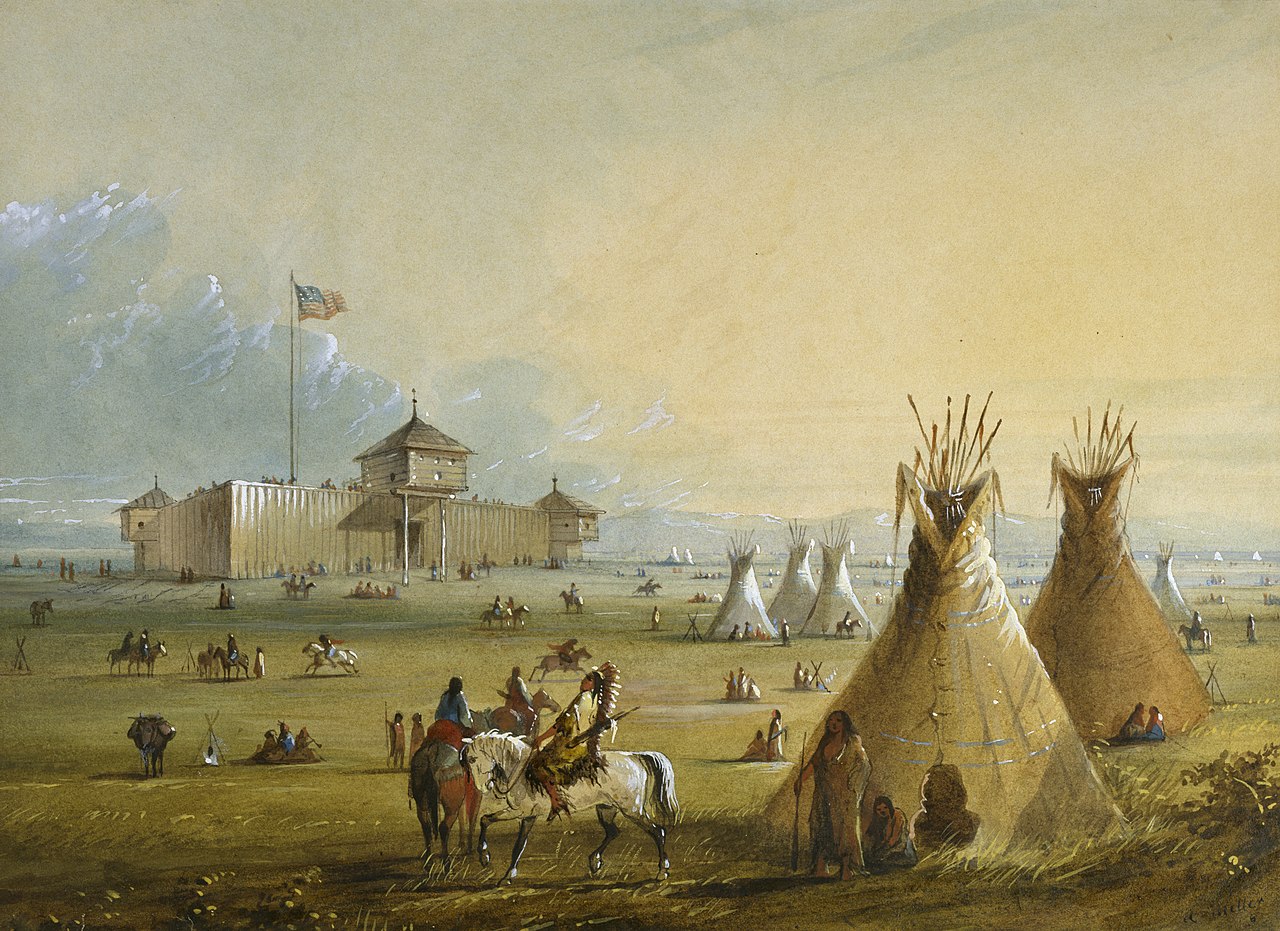
Первые белые поселения на Великих равнинах были фортами, особенно вдоль тропы Санта-Фе, и торговыми постами. Некоторые из первых построенных были:

Железные дороги открыли Великие равнины для поселения, что позволило отправлять пшеницу и другие культуры по низкой цене на городские рынки на Востоке и за границу. Земля под фермами была бесплатной для американских поселенцев. Железные дороги продавали свою землю по низким ценам иммигрантам в надежде, что они начнут генерировать трафик, как только будут созданы фермы. Иммигранты хлынули потоком, особенно из Германии и Скандинавии. На равнинах очень немногие одинокие мужчины пытались управлять фермой или ранчо самостоятельно; они понимали необходимость трудолюбивой жены и многочисленных детей, чтобы справляться со многими обязанностями. [60] В первые годы поселения женщины-фермеры играли неотъемлемую роль в обеспечении выживания семьи, работая на открытом воздухе. Примерно через одно поколение женщины все чаще покидали поля, тем самым переопределяя свои роли в семье. Новые технологии побуждали женщин обращаться к домашним обязанностям, включая швейные и стиральные машины. Средства массовой информации и правительственные агенты по распространению знаний продвигали движение «научного домоводства», а также устраивали окружные ярмарки, на которых демонстрировались достижения в области домашней кулинарии и консервирования, публиковали колонки с советами для женщин по ведению фермерской бухгалтерии и курсы по домоводству в школах. [61]
Восточный образ фермерской жизни в прериях подчеркивал изоляцию одинокого фермера и его жены, однако жители равнин создавали для себя насыщенную общественную жизнь. Они часто спонсировали мероприятия, которые сочетали работу, еду и развлечения, такие как возведение амбаров , лущение кукурузы, стегание пчел, [62] собрания на ферме , церковные мероприятия и школьные мероприятия. Женщины организовывали общие обеды и мероприятия по сбору продуктов, а также длительные визиты между семьями. [63]
Прогрессивное движение было реформаторским движением, которое имело место во всех частях страны в конце 19-го и начале 20-го веков. Движение стремилось решать социальные, политические и экономические проблемы, возникшие в результате промышленной революции. Прогрессисты считали, что правительство может сыграть роль в решении этих проблем, регулируя бизнес, защищая рабочих и предоставляя программы социального обеспечения. [64] [65]
Штаты Равнин были очагом прогрессивной активности. Многие из реформ, которые были приняты на национальном уровне, были впервые реализованы в штатах Равнин. [66] Например, процесс инициативы и референдума, который позволяет избирателям напрямую принимать законы, был впервые принят в Южной Дакоте в 1898 году. Прямые предварительные выборы, которые позволяют избирателям выбирать кандидатов своей партии на предварительных выборах, были впервые приняты в Висконсине в 1903 году. [67] [68]
Прогрессивные реформаторы Великих равнин сосредоточились на приоритетных вопросах, в частности: [69] [70]
Прогрессивисты Великих равнин с большей вероятностью поддерживали прямую демократию, избирательное право для женщин и сухой закон, чем их коллеги в других местах. Они также с большей вероятностью поддерживали государственные предприятия, особенно те, которые были посвящены экономическому развитию. Прогрессивизм равнин был более радикальным, чем прогрессизм в восточных штатах, с большим акцентом на прямую демократию, избирательное право для женщин и сухой закон. Прогрессивисты равнин были более изоляционистскими в отношении внешней политики, в основном в ответ на большие немецкие и скандинавские элементы. Социалисты были более активны, чем в других местах. Прогрессивные реформы оказали значительное долгосрочное влияние на регион. Они помогли улучшить жизнь рабочих, фермеров и потребителей. Они также помогли сделать штаты равнин более демократичными и отзывчивыми к потребностям своих граждан. [72]

Регион, примерно центрированный на Оклахомском выступе, был известен как Пыльная буря в конце 1920-х и начале 1930-х годов, включая юго-восточный Колорадо, юго-западный Канзас, Техасский выступ и крайний северо-восток Нью-Мексико. Последствия продолжительной засухи, ненадлежащее земледелие и финансовые кризисы Великой депрессии заставили многих фермеров покинуть землю по всем Великим равнинам. [ необходима цитата ]
Начиная с 1950-х годов многие районы Великих равнин стали плодородными сельскохозяйственными угодьями благодаря обширному орошению больших земельных владений. Соединенные Штаты являются крупным экспортером сельскохозяйственной продукции. Южная часть Великих равнин лежит над водоносным горизонтом Огаллала , огромным подземным слоем водоносных пластов. В более сухих районах Великих равнин широко используется круговое орошение , что приводит к истощению водоносного горизонта со скоростью, превышающей способность почвы к пополнению. [73]
Сельские равнины потеряли треть своего населения с 1920 года. Несколько сотен тысяч квадратных миль Великих равнин имеют менее 6 жителей на квадратную милю (2,3/км 2 ), стандарт плотности, который Фредерик Джексон Тернер использовал, чтобы объявить американскую границу «закрытой» в 1893 году. Во многих из них менее 2 жителей на квадратную милю (0,77/км 2 ). По словам историка Канзаса Дэниела Фицджеральда, только в Канзасе насчитывается более 6000 городов-призраков. Эта проблема часто усугубляется консолидацией ферм и трудностями привлечения современной промышленности в регион. Кроме того, меньшее население школьного возраста вынудило консолидацию школьных округов и закрытие средних школ в некоторых общинах. Продолжающаяся потеря населения привела некоторых к предположению, что текущее использование более засушливых частей Великих равнин не является устойчивым, [74] и было выдвинуто предложение вернуть приблизительно 139 000 кв. миль (360 000 км2 ) этих более засушливых частей исконным прериям в качестве общинных земель для бизонов .
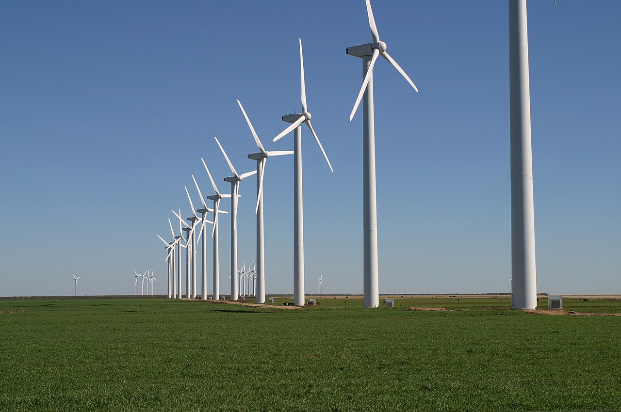
Великие равнины вносят значительный вклад в ветроэнергетику в Соединенных Штатах . Т. Бун Пикенс разработал ветровые электростанции после карьеры в качестве руководителя нефтяной компании, и он призвал США инвестировать 1 триллион долларов в строительство дополнительных 200 000 МВт ветроэнергетики на равнинах в рамках своего плана Пикенса . Он привел Суитуотер, штат Техас , в качестве примера экономического возрождения, вызванного развитием ветроэнергетики. [75] [76] [77]
Простираясь от западного Техаса и восточного Нью-Мексико через Оклахому, Колорадо, Канзас, Небраску, Вайоминг, Монтану, Дакоту и Канаду, обширные западные равнины часто кажутся редкими...

_(cropped).jpg/1280px-Black-footed_Ferrets_in_Preconditioning_Pens_(15519959116)_(cropped).jpg)
.jpg/1280px-Swift_Fox_(cropped).jpg)
.jpg/1280px-Tympanuchus_pallidicinctus-1jpg_(cropped).jpg)
_(8726969667).jpg/1280px-Great_Plains_Rat_Snake_(Pantherophis_emoryi)_(8726969667).jpg)
.jpg/1280px-Great_Plains_toad_(cropped).jpg)
.jpg/1280px-Amerikanischer_Totengr%C3%A4ber_(Nicrophorus_americanus).jpg)


