Торонто — самый густонаселенный город в Канаде и столица канадской провинции Онтарио . С населением 2 794 356 человек в 2021 году [10] это четвертый по численности населения город в Северной Америке . Город является якорем Золотой Подковы , городской агломерации с населением 9 765 188 человек (по состоянию на 2021 год), окружающей западный конец озера Онтарио , [11] в то время как население Большого Торонто в 2021 году составляло 6 712 341 человек. [10] Торонто — международный центр бизнеса, финансов, искусств, спорта и культуры, а также один из самых многокультурных и космополитичных городов в мире. [12] [13] [14]
Коренные народы путешествовали и населяли район Торонто, расположенный на широком наклонном плато, перемежающемся реками, глубокими оврагами и городским лесом , на протяжении более 10 000 лет. [15] После широко оспариваемой покупки Торонто , когда Миссиссога сдала территорию британской короне , [16] британцы основали город Йорк в 1793 году и позже назначили его столицей Верхней Канады . [17] Во время войны 1812 года город был местом битвы при Йорке и сильно пострадал от американских войск . [18] Йорк был переименован и включен в состав Торонто в 1834 году . Он был назначен столицей провинции Онтарио в 1867 году во время Канадской конфедерации . [19] С тех пор город расширился за пределы своих первоначальных границ за счет присоединений и слияний , и его нынешняя площадь составляет 630,2 км2 ( 243,3 кв. мили).
Разнообразное население Торонто отражает его нынешнюю и историческую роль как важного пункта назначения для иммигрантов в Канаду . [20] [21] Около половины его жителей родились за пределами Канады, и среди его жителей представлены более 200 этнических групп . [22] Хотя большинство жителей Торонто говорят на английском как на своем основном языке, в городе говорят на более чем 160 языках. [23] Мэр Торонто избирается прямым всенародным голосованием в качестве главного исполнительного директора города. Городской совет Торонто является однопалатным законодательным органом, в состав которого с муниципальных выборов 2018 года входят 25 советников , представляющих географические районы по всему городу. [24]
Торонто является выдающимся центром музыки, [25] театра, [26] кинопроизводства, [27] и телевидения, [28] а также является домом для штаб-квартир основных национальных вещательных сетей и средств массовой информации Канады . [29] Его разнообразные культурные учреждения , [30] которые включают в себя многочисленные музеи и галереи , фестивали и общественные мероприятия , развлекательные районы, национальные исторические места и спортивные мероприятия , [31] привлекают более 43 миллионов туристов каждый год. [32] [33] Торонто известен своими многочисленными небоскребами и высотными зданиями , [34] в частности, самым высоким отдельно стоящим сооружением на суше за пределами Азии , CN Tower . [35]
В городе находится фондовая биржа Торонто , штаб-квартиры пяти крупнейших банков Канады , [36] и штаб-квартиры многих крупных канадских и многонациональных корпораций. [37] Его экономика сильно диверсифицирована и имеет сильные стороны в технологиях, дизайне, финансовых услугах, науках о жизни, образовании, искусстве, моде, аэрокосмической отрасли, экологических инновациях, сфере общественного питания и туризме. [38] [39] [40] Торонто является третьим по величине технологическим центром в Северной Америке после Кремниевой долины и Нью-Йорка , и самым быстрорастущим центром. [41]
Слово Toronto было записано с различными вариантами написания на французском и английском языках, включая Tarento , Tarontha , Taronto , Toranto , Torento , Toronto и Toronton . [42] Taronto относится к «узким местам», каналу воды, через который озеро Симко впадает в озеро Кучичинг , где гуроны посадили саженцы деревьев, чтобы ловить рыбу. Этот узкий проход был назван мохоками tkaronto , что означает «там, где деревья стоят в воде» [43] [44] [45] и был записан еще в 1615 году Самуэлем де Шампленом . [46] Слово Toronto , означающее «изобилие», также появляется во французском лексиконе 1632 года на языке гуронов , который также является ирокезским языком. [47] Оно также появляется на французских картах, ссылаясь на различные места, включая залив Джорджиан-Бей, озеро Симко и несколько рек. [48] Маршрут переправы из озера Онтарио в озеро Гурон , проходящий через эту точку и известный как Торонтская тропа переноски , привёл к широкому использованию этого названия.
Произношение названия города в целом / təˈrɒntoʊ / tə-RONT-oh, которое местные жители произносят[təˈɹɒnoʊ]или[ˈtɹɒnoʊ], оставляя вторую букву «t» беззвучной.[49][50][51]
Место Торонто лежало у входа на один из старейших маршрутов на северо-запад, маршрут, известный и используемый гуронами, ирокезами и оджибве . Археологические памятники показывают свидетельства человеческого обитания, датируемого тысячелетиями. Место имело стратегическое значение с самого начала письменной истории Онтарио. [52]
В 1660-х годах ирокезы основали две деревни в пределах современного Торонто, Ганацеквьягон (Бид-Хилл) на берегах реки Руж и Тейайагон на берегах реки Хамбер . К 1701 году миссисаугасы вытеснили ирокезов, которые покинули район Торонто в конце Бобровых войн , и большинство из них вернулись на родину в современный штат Нью-Йорк. [53]
Французские торговцы основали форт Руйе в 1750 году ( позднее там разместился нынешний выставочный комплекс ), но покинули его в 1759 году во время Семилетней войны . [54] В этой войне британцы победили французов и их местных союзников, и в 1763 году эта территория стала частью британской колонии Квебек .
Во время Войны за независимость США сюда прибыл поток британских поселенцев, поскольку лоялисты Объединенной империи бежали на контролируемые британцами земли к северу от озера Онтарио. Корона предоставила им землю, чтобы компенсировать их потери в Тринадцати колониях. Создавалась новая провинция Верхняя Канада, и ей нужна была столица. В 1787 году британский лорд Дорчестер организовал покупку Торонто с миссиссогасами из Новой кредитной первой нации, тем самым обеспечив себе более четверти миллиона акров (1000 км 2 ) земли в районе Торонто. [55] Дорчестер намеревался назвать это место Торонто. [48] Первые 25 лет после покупки Торонто были спокойными, хотя в этом районе «время от времени появлялись независимые торговцы мехом», с обычными жалобами на разврат и пьянство. [52]
В 1793 году губернатор Джон Грейвс Симко основал город Йорк на землях Торонто Покупка, назвав его в честь принца Фредерика, герцога Йоркского и Олбани . Симко решил перенести столицу Верхней Канады из Ньюарка (Ниагара-он-те-Лейк) в Йорк, [56] полагая, что новое место будет менее уязвимо для атак со стороны Соединенных Штатов. [57] Гарнизон Йорка был построен у входа в естественную гавань города, защищенную длинным полуостровом песчаной косы. Городское поселение образовалось на восточном конце гавани за полуостровом, недалеко от современного пересечения Парламент-стрит и Фронт-стрит (в районе « Старого города »).

В 1813 году, как часть войны 1812 года , битва за Йорк закончилась захватом и разграблением города силами Соединенных Штатов. [58] Джон Страхан вел переговоры о сдаче города. Американские солдаты уничтожили большую часть гарнизона и подожгли здания парламента во время своей пятидневной оккупации. Из-за разграбления Йорка британские войска позже в войне отомстили, сжегши Вашингтон, округ Колумбия
Йорк был включен в состав города Торонто 6 марта 1834 года, приняв коренное название. [ требуется ссылка ] Политик-реформатор Уильям Лайон Маккензи стал первым мэром Торонто . Позже Маккензи возглавил неудачное восстание в Верхней Канаде в 1837 году против британского колониального правительства.
Население Торонто в 9000 человек включало некоторое количество афроамериканских рабов, [ требуется ссылка ] некоторые из которых были привезены лоялистами, и чернокожих лоялистов , которых Корона освободила (большинство последних были переселены в Новую Шотландию). К 1834 году рабы-беженцы с американского Юга также иммигрировали в Торонто, чтобы обрести свободу. [59] Рабство было полностью запрещено в Верхней Канаде (и по всей Британской империи) в 1834 году. [60] Жители Торонто интегрировали цветных людей в свое общество. В 1840-х годах закусочная на Фредерик-стрит и Кинг-стрит, место торгового процветания в раннем городе, принадлежала чернокожему человеку по имени Блоксом. [61]

Будучи основным пунктом назначения для иммигрантов в Канаду, город быстро рос в течение оставшейся части 19-го века. Первая значительная волна иммигрантов была ирландцами, бежавшими от Великого ирландского голода ; большинство из них были католиками . К 1851 году население ирландского происхождения стало крупнейшей этнической группой в городе. Шотландское и английское население приветствовало меньшее количество протестантских ирландских иммигрантов, некоторые из которых были из того, что сейчас является Северной Ирландией, что дало Ордену оранжистов значительное и долгосрочное влияние на общество Торонто. Почти каждый мэр Торонто был членом Ордена оранжистов между 1850 и 1950 годами, и город иногда называли « Белфастом Канады» из-за влияния оранжистов на муниципальную политику и администрацию. [62]
В течение коротких периодов Торонто дважды был столицей объединенной провинции Канада : сначала с 1849 по 1851 год, после волнений в Монреале, а затем с 1855 по 1859 год. После этой даты Квебек был назначен столицей до 1865 года (за два года до Канадской конфедерации). С тех пор столицей Канады остается Оттава , Онтарио. [63]

Торонто стал столицей провинции Онтарио после ее официального создания в 1867 году. Резиденция правительства Онтарио ненадолго вернулась в то же здание, где располагалось Третье здание парламента Верхней Канады, прежде чем в 1893 году переехать в Законодательное здание Онтарио в Королевском парке . Из-за своего статуса столицы провинции в городе также располагалась резиденция вице-королевского представителя Короны в Онтарио .
Задолго до того, как в 1876 году был основан Королевский военный колледж Канады , сторонники этой концепции предлагали военные колледжи в Канаде. Укомплектованные британскими регулярными войсками, взрослые студенты мужского пола проходили трехмесячный военный курс в Школе военной подготовки в Торонто. Основанная Генеральным приказом о милиции в 1864 году, школа позволяла офицерам милиции или кандидатам на назначение или повышение в милицию изучать военные обязанности, строевую подготовку и дисциплину, командовать ротой на батальонной строевой подготовке, строевой подготовке роты на ротной строевой подготовке, внутреннюю экономику роты и обязанности офицера роты. [64] Школа была сохранена в Конфедерации в 1867 году. В 1868 году в Торонто были сформированы школы кавалерии и артиллерийской подготовки. [65]
.jpg/1280px-Yorkville_Town_Hall,_Yonge_St.,_west_side,_opposite_Collier_St._(16526085614).jpg)
В 19 веке город построил обширную канализационную систему для улучшения санитарных условий, а улицы регулярно освещались газовым освещением . [ требуется ссылка ] Были построены железнодорожные линии дальнего следования, включая маршрут, завершенный в 1854 году, соединяющий Торонто с Верхними Великими озерами. Гранд-Транк-Рейлвей и Северная железная дорога Канады объединились в строительстве первой станции Union в центре города. Появление железной дороги резко увеличило число прибывающих иммигрантов, торговли и промышленности, как и пароходы и шхуны озера Онтарио, заходящие в порт ранее. Это позволило Торонто стать крупными воротами, связывающими мир с внутренними районами североамериканского континента. Расширение порта и железнодорожных сооружений привело к поставке северной древесины на экспорт и импорту угля из Пенсильвании. Промышленность доминировала на набережной в течение следующих 100 лет.
В конце 19 века Торонто стал крупнейшим центром перегонки алкоголя (в частности, крепких спиртных напитков ) в Северной Америке. К 1860-м годам деятельность Gooderham and Worts Distillery стала крупнейшей в мире фабрикой по производству виски . [ требуется ссылка ] Сохранившаяся часть этой некогда доминирующей местной промышленности осталась в районе Distillery District . Гавань обеспечивала доступ к импорту зерна и сахара, используемых в переработке.

Конные трамваи уступили место электрическим трамваям в 1891 году, когда город предоставил право на эксплуатацию транзитной франшизы Toronto Railway Company . Система общественного транспорта перешла в государственную собственность в 1921 году как Toronto Transportation Commission , позже переименованная в Toronto Transit Commission . В настоящее время система имеет третью по величине пассажиропоток среди всех городских систем общественного транспорта в Северной Америке . [66]
.jpg/1280px-Toronto_Fire_Ruins,_Front_Street_April_19th,_1904_(HS85-10-14899).jpg)
Великий пожар в Торонто 1904 года уничтожил большую часть центра Торонто . Пожар уничтожил более 100 зданий. [67] В результате пожара погиб один человек, Джон Крофт, который был экспертом по взрывчатым веществам, расчищавшим руины от пожара. [68] Он нанес ущерб в размере 10 387 000 канадских долларов (примерно 277 600 000 канадских долларов в пересчете на 2020 год). [69]
Город принял новые европейские иммигрантские группы с конца 19-го века до начала 20-го века, в частности немцев, французов, итальянцев и евреев. За ними вскоре последовали русские, поляки и другие восточноевропейские народы, в дополнение к китайцам, прибывшим с Запада. Как и ирландцы до них, многие из этих мигрантов жили в переполненных трущобах типа хижин, таких как « Уорд », который был сосредоточен на Бэй-стрит , теперь сердце Финансового района страны .
По мере того, как новые мигранты начинали преуспевать, они переезжали в более благоустроенные места в других районах, что сейчас понимается как последовательные волны заселения. Несмотря на быстрый рост, к 1920-м годам население и экономическое значение Торонто в Канаде оставались вторыми после гораздо более давно существующего Монреаля , Квебек. Однако к 1934 году фондовая биржа Торонто стала крупнейшей в стране.

В 1954 году город Торонто и 12 прилегающих муниципалитетов были объединены в региональное правительство, известное как Метрополитен Торонто . [70] Послевоенный бум привел к быстрому развитию пригородов. Считалось, что скоординированная стратегия землепользования и общие услуги обеспечат большую эффективность для региона. Метрополитенское правительство начало управлять услугами, которые пересекали муниципальные границы, включая автомагистрали, полицейские службы, водоснабжение и общественный транспорт . В том году, спустя полвека после Великого пожара 1904 года, катастрофа снова обрушилась на город, когда ураган Хейзел принес сильные ветры и внезапное наводнение. В районе Торонто погибло 81 человек, почти 1900 семей остались без крова, а ураган нанес ущерб на сумму более 25 миллионов канадских долларов . [71]
В 1967 году семь самых маленьких муниципалитетов столичного Торонто были объединены с более крупными соседями, в результате чего образовалась конфигурация из шести муниципалитетов, включающая бывший город Торонто и окружающие его муниципалитеты Ист-Йорк , Этобико , Норт-Йорк , Скарборо и Йорк . [72]
В течение десятилетий после Второй мировой войны сюда прибывали беженцы из охваченной войной Европы и китайские соискатели работы, а также строительные рабочие, особенно из Италии и Португалии. Население Торонто выросло до более чем одного миллиона в 1951 году, когда началась масштабная пригородная застройка, и удвоилось до двух миллионов к 1971 году. После ликвидации расово-ориентированной иммиграционной политики к концу 1960-х годов Торонто стал местом назначения для иммигрантов со всего мира. К 1980-м годам Торонто превзошел Монреаль как самый густонаселенный город Канады и главный экономический центр. В это время, отчасти из-за политической неопределенности, вызванной возрождением движения за суверенитет Квебека , многие национальные и многонациональные корпорации переместили свои головные офисы из Монреаля в Торонто и города Западной Канады . [73]

1 января 1998 года Торонто был значительно расширен, не путем традиционных аннексий , а путем объединения муниципалитета Метрополитен Торонто и шести его низших составляющих муниципалитетов: Ист-Йорк, Этобико, Норт-Йорк, Скарборо, Йорк и самого первоначального города. Они были распущены актом правительства Онтарио и преобразованы в одноуровневый Город Торонто (в просторечии именуемый « мегаполисом »), заменив все шесть правительств.
Слияние было предложено в качестве меры экономии средств провинциальным правительством Прогрессивных Консервативных Партий под руководством премьер-министра Майка Харриса . Объявление вызвало громкие возражения общественности. В марте 1997 года референдум во всех шести муниципалитетах дал голоса более 3:1 против слияния. [74] Однако муниципальные органы власти в Канаде являются творениями провинциальных правительств, и референдумы не имеют практически никакой юридической силы. Таким образом, правительство Харриса могло законно игнорировать результаты референдума и сделало это в апреле, когда оно представило Закон о городе Торонто . Обе оппозиционные партии устроили обструкцию в провинциальном законодательном собрании, предложив более 12 000 поправок, которые позволили жителям улиц предлагаемого мегаполиса принимать участие в публичных слушаниях по слиянию и добавлению исторических обозначений улицам. [75] Это только отсрочило неизбежное принятие законопроекта, учитывая большинство Прогрессивных Консерваторов.
Мэр Норт-Йорка Мел Ластман стал первым мэром «мегаполиса» и 62-м мэром Торонто, одержав победу на выборах . [76] Ластман привлек к себе внимание всей страны после многочисленных снежных бурь, включая январскую метель 1999 года , выпавшую 118 сантиметров (46 дюймов) снега и фактически парализовавшую город. [77] [78] Он призвал канадскую армию помочь с уборкой снега, используя их оборудование для усиления полиции и аварийно-спасательных служб. Этот шаг был высмеян некоторыми в других частях страны, отчасти из-за того, что было воспринято как легкомысленное использование ресурсов. [79] [80]

Город привлек международное внимание в 2003 году, когда стал центром крупной вспышки атипичной пневмонии (ТОРС). Попытки общественного здравоохранения предотвратить распространение болезни в других местах временно ослабили местную экономику. [81] С 14 по 17 августа 2003 года город пострадал от масштабного отключения электроэнергии , которое затронуло миллионы жителей Торонто (оно также затронуло большую часть Южного Онтарио и части Соединенных Штатов), заперев несколько сотен людей в высотных зданиях, выбив светофоры и приостановив движение метро и трамваев по всему городу в течение вышеупомянутых дней. [82]
6 марта 2009 года город отпраздновал 175-ю годовщину своего основания как города Торонто в 1834 году. Торонто принимал 4-й саммит G20 26–27 июня 2010 года. Это включало в себя крупнейшую операцию по обеспечению безопасности в истории Канады. После масштабных протестов и беспорядков правоохранительные органы арестовали более 1000 человек, что стало крупнейшим массовым арестом в истории Канады. [83]

8 июля 2013 года сильное наводнение обрушилось на Торонто после полудня медленных, интенсивных гроз. По оценкам Toronto Hydro, 450 000 человек остались без электричества после шторма, а международный аэропорт Торонто Пирсон сообщил о выпавшем за пять часов количестве осадков в 126 мм (5 дюймов), что больше, чем во время урагана Хейзел. [84] В течение шести месяцев, с 20 по 22 декабря 2013 года, Торонто был практически парализован сильнейшим ледяным штормом в истории города, сопоставимым по силе со ледяным штормом 1998 года (который в основном затронул юго-восточную часть Онтарио и Квебек). В разгар шторма более 300 000 клиентов Toronto Hydro остались без электричества или отопления. [85] Торонто принимал WorldPride в июне 2014 года, [86] а также Пан- и Парапанамериканские игры в 2015 году . [87]
Город продолжает расти и привлекать иммигрантов. Исследование, проведенное в 2019 году Университетом Торонто Метрополитен (тогда известным как Университет Райерсона), показало, что Торонто был самым быстрорастущим городом в Северной Америке. В период с июля 2017 года по июль 2018 года в городе выросло 77 435 человек. Столичный район Торонто стал вторым по быстрому росту столичным районом в Северной Америке, добавив 125 298 человек по сравнению с 131 767 в метроплексе Даллас–Форт-Уэрт–Арлингтон в Техасе. Большой рост в столичном районе Торонто объясняется международной миграцией в Торонто. [88]
Пандемия COVID-19 в Канаде впервые возникла в Торонто и стала одной из самых горячих точек в стране . [89] [90]
Торонто был назван одним из 16 городов Северной Америки (и одним из двух городов Канады), где пройдут матчи чемпионата мира по футболу FIFA 2026 года . [91]

Торонто занимает площадь в 630 квадратных километров (243 квадратных миль), [92] с максимальным расстоянием с севера на юг в 21 километр (13 миль). Он имеет максимальное расстояние с востока на запад в 43 км (27 миль), и имеет 46-километровую (29 миль) длинную береговую линию на северо-западном берегу озера Онтарио . Острова Торонто и Портовые земли простираются в озеро, обеспечивая несколько защищенную гавань Торонто к югу от центра города. [93] Внешняя гавань была построена к юго-востоку от центра города в 1950-х и 1960-х годах, и теперь она используется для отдыха. Границы города образованы озером Онтарио на юге, западной границей парка Мари Кертис , ручьем Этобикоук , авеню Эглинтон и шоссе 427 на западе, авеню Стилз на севере и рекой Руж и городской линией Скарборо–Пикеринг на востоке.

Город в основном представляет собой плоские или пологие холмы, а земля плавно поднимается вверх от озера. Равнинная местность прерывается системой оврагов Торонто , которая прорезана многочисленными ручьями и реками системы водных путей Торонто , в первую очередь рекой Хамбер на западном конце, рекой Дон к востоку от центра города (эти две реки обрамляют и определяют гавань Торонто) и рекой Руж на восточных границах города. Большинство оврагов и долин в Торонто сегодня являются парковыми зонами, а вдоль оврагов и долин проложены рекреационные тропы. Первоначальный город был заложен в виде сетки на плоской равнине к северу от гавани, и этот план расширялся по мере роста города. Ширина и глубина нескольких оврагов и долин таковы, что несколько улиц сетки, таких как Финч-авеню , Лесли-стрит , Лоуренс-авеню и Сент-Клер-авеню , заканчиваются на одной стороне оврага или долины и продолжаются на другой стороне. В Торонто много мостов, пересекающих овраги. Большие мосты, такие как виадук Принца Эдуарда, были построены, чтобы перекрыть широкие речные долины.
Несмотря на глубокие овраги, Торонто не является исключительно холмистым, но его высота неуклонно увеличивается по мере удаления от озера. Перепады высот варьируются от 76,5 метров (251 фут) над уровнем моря на берегу озера Онтарио до 209 м (686 футов) над уровнем моря около территории Йоркского университета в северной части города на пересечении Кил-стрит и Стилс-авеню. [94] Иногда встречаются холмистые районы; в частности, в центре Торонто есть несколько резко наклонных холмов. Озеро Онтарио иногда видно с вершин этих хребтов вплоть до Эглинтон-авеню, в 7–8 километрах (4,3–5,0 миль) вглубь страны.

Другая важная географическая особенность Торонто — его уступы. Во время последнего ледникового периода нижняя часть Торонто находилась под ледниковым озером Ирокез . Сегодня серия уступов отмечает бывшую границу озера, известную как «береговая линия Ирокеза». Уступы наиболее заметны от Виктория Парк Авеню до устья Хайленд Крик , где они образуют утесы Скарборо . Другие наблюдаемые участки включают область около Сент-Клер Авеню Вест между Батерст-стрит и рекой Дон, и к северу от Давенпорт-роуд от Каледония до Спадина-роуд ; территория Каса Лома находится над этим уступом. [95]
География берега озера кардинально изменилась с момента первого поселения Торонто. Большая часть земли на северном берегу гавани представляет собой свалку, засыпанную в конце 19 века. До этого времени доки на берегу озера (тогда известные как причалы) были отнесены дальше вглубь страны, чем сегодня. Большая часть прилегающих портовых земель на восточной стороне гавани представляла собой водно-болотные угодья, засыпанные в начале 20 века. [96] Береговая линия от гавани на западе до реки Хамбер была продлена в озеро. Дальше на запад свалка использовалась для создания расширений земли, таких как парк залива Хамбер.
.JPG/1280px-Views_from_the_CN_Tower_Laslovarga_(20).JPG)
Острова Торонто были естественным полуостровом, пока шторм в 1858 году не разорвал их связь с материком, [97] создав канал к гавани. Полуостров был образован прибрежным дрейфом, который забирал осадки, отложенные вдоль берега утесов Скарборо, и переносил их в район островов.
Другим источником осадка для водно-болотных угодий Порт-Лендс и полуострова было отложение реки Дон, которая прорезала широкую долину через осадочную землю Торонто и отложила ее в мелководной гавани. Гавань и русло реки Дон многократно подвергались дноуглубительным работам для судоходства. Нижняя часть реки Дон была выпрямлена и направлена в 19 веке. Бывшее устье впадало в водно-болотное угодье; сегодня река Дон впадает в гавань через бетонный водный путь, канал Китинг . Чтобы смягчить наводнения в этом районе, а также создать парковую зону, в первой половине 2020-х годов на юге строится второе, более естественное устье, тем самым создавая остров Вильерс .

Торонто охватывает территорию, ранее управляемую несколькими отдельными муниципалитетами, которые были объединены в течение многих лет. Каждый из них развивал свою историю и идентичность в течение многих лет, и их названия остаются общеупотребительными среди жителей Торонто. Бывшие муниципалитеты включают Ист-Йорк, Этобико, Форест-Хилл , Мимико , Норт-Йорк, Паркдейл , Скарборо, Суонси , Уэстон и Йорк. По всему городу существуют сотни небольших районов и несколько более крупных районов, охватывающих несколько квадратных километров. [ требуется цитата ]
Многие жилые кварталы Торонто выражают характер, отличный от небоскребов в коммерческом центре. Жилые здания викторианской и эдвардианской эпохи можно найти в таких анклавах, как Rosedale , Cabbagetown , The Annex и Yorkville . [98] Район Wychwood Park , исторически значимый архитектурой своих домов и являющийся одним из самых ранних спланированных сообществ Торонто, был обозначен как район сохранения наследия Онтарио в 1985 году. [99] Район Casa Loma назван в честь «Casa Loma», замка, построенного в 1911 году сэром Генри Пеллатом , с садами, башнями, конюшнями, лифтом, секретными проходами и боулингом. [100] Spadina House — это особняк 19 века , который сейчас является музеем. [101]

До объединения город Торонто охватывает центр города и старые кварталы на востоке, западе и севере. Это самая густонаселенная часть города. Финансовый район включает First Canadian Place , Toronto-Dominion Centre , Scotia Plaza , Royal Bank Plaza , Commerce Court и Brookfield Place . Эта область включает, среди прочего, кварталы St. James Town , Garden District , St. Lawrence , Corktown и Church and Wellesley . Оттуда линия горизонта Торонто простирается на север вдоль улицы Yonge Street. [ требуется цитата ]
Старый Торонто также является домом для многих исторически богатых жилых анклавов, таких как Йорквилл , Роздейл, Аннекс, Форест-Хилл, Лоуренс-Парк , Литтон-Парк , Дир-Парк , Мур-Парк и Каса-Лома, большинство из которых простираются от центра города на север. [ требуется ссылка ] К востоку и западу от центра города, такие районы, как Кенсингтон-Маркет , Чайнатаун , Лесливилл , Кэббеджтаун и Ривердейл, являются домом для оживленных коммерческих и культурных зон, а также сообществ художников с лофтами-студиями, со многими профессионалами среднего и высшего класса. [ требуется ссылка ] Другие районы в центральной части города сохраняют этническую идентичность, включая два меньших Чайнатауна, район Гриктаун , Маленькую Италию , Португальскую деревню и Маленькую Индию , среди прочих. [102]

Внутренние пригороды находятся в пределах бывших муниципалитетов Йорка и Ист-Йорка. [103] Это зрелые и традиционно рабочие районы, состоящие в основном из небольших односемейных домов и небольших многоквартирных домов, построенных после Первой мировой войны. [103] Такие районы, как Кресент-Таун , Торнклифф-Парк , Флемингдон-Парк , Уэстон и Оуквуд-Виллидж , состоят в основном из многоэтажных квартир, в которых проживает множество новых семей иммигрантов. В 2000-х годах многие районы стали этнически разнообразными и подверглись джентрификации из-за роста населения и жилищного бума в конце 1990-х и начале 21-го века. Первыми пострадавшими районами были Лисайд и Северный Торонто , постепенно переходя в западные районы Йорка. [ требуется ссылка ]
.jpg/1280px-York_after_sunset_(2855524410).jpg)
Внешние пригороды, включающие бывшие муниципалитеты Этобико (запад), Скарборо (восток) и Норт-Йорк (север), в значительной степени сохраняют план сетки, заложенный до послевоенного развития. [104] Секции были давно созданными и быстро растущими городами до начала бума пригородного жилья и появления столичного правительства, существующих городов или деревень, таких как Мимико, Ислингтон и Нью-Торонто в Этобико; Уиллоудейл , Ньютонбрук и Даунсвью в Норт-Йорке; Азенкур , Вексфорд и Вест-Хилл в Скарборо, где пригородное развитие бурно развивалось вокруг или между этими и другими городами, начиная с конца 1940-х годов. Были построены высококлассные кварталы, такие как Bridle Path в Норт-Йорке, район, окружающий утесы Скарборо в Гилдвуде , и большая часть центрального Этобико, такие как Humber Valley Village и The Kingsway . Одним из крупнейших и самых ранних «планируемых сообществ» был Дон Миллс , части которого были впервые построены в 1950-х годах. [105] Поэтапная застройка, смешивающая отдельно стоящее жилье с многоквартирными домами с более высокой плотностью застройки, стала более популярной как модель пригородной застройки. В конце 20-го века, Норт-Йорк Сити Центр и Скарборо Сити Центр развивали отдельные районы в центре города за пределами центра Торонто после того, как бывшие районы были повышены до городов. [106] Высотное строительство в этих районах дало этим бывшим муниципалитетам собственные отличительные очертания с обслуживающими их транзитными коридорами с высокой плотностью; некоторые из этих разработок также ориентированы на транзит . [ требуется ссылка ]
.jpg/1280px-Toronto's_Distillery_District_in_2023_(52716109425).jpg)
In the 1800s, a thriving industrial area developed around Toronto Harbour and the lower Don River mouth, linked by rail and water to Canada and the United States. Examples included the Gooderham and Worts Distillery, Canadian Malting Company, the Toronto Rolling Mills, the Union Stockyards and the Davies pork processing facility (the inspiration for the "Hogtown" nickname).[107][108] This industrial area expanded west along the harbour and rail lines and was supplemented by the infilling of the marshlands on the east side of the harbour to create the Port Lands. A garment industry developed along lower Spadina Avenue, the "Fashion District". Beginning in the late 19th century, industrial areas were set up on the outskirts, such as West Toronto / The Junction, where the Stockyards relocated in 1903.[109] The Great Fire of 1904 destroyed a large amount of industry in the downtown. Some companies moved west along King Street, and some moved as far west as Dufferin Street, where the large Massey-Harris farm equipment manufacturing complex was located.[110] Over time, pockets of industrial land mostly followed rail lines and later highway corridors as the city grew outwards. This trend continues to this day; the largest factories and distribution warehouses are in the suburban environs of Peel and York Regions, but also within the current city: Etobicoke (concentrated around Pearson Airport), North York, and Scarborough.[citation needed]
.JPG/1280px-Skyline,_2013_09_14_(17).JPG)
Many of Toronto's former industrial sites close to (or in) downtown have been redeveloped, including parts of the Toronto waterfront, the rail yards west of downtown, and Liberty Village, the Massey-Harris district and large-scale development is underway in the West Don Lands.[citation needed]The Gooderham & Worts Distillery produced spirits until 1990 and is preserved today as the "Distillery District", the largest and best-preserved collection of Victorian industrial architecture in North America.[111] Some industry remains in the area, including the Redpath Sugar Refinery. Similar areas that retain their industrial character but are now largely residential are the Fashion District, Corktown, and parts of South Riverdale and Leslieville. Toronto still has some active older industrial areas, such as Brockton Village, Mimico and New Toronto. In the west end of Old Toronto and York, the Weston/Mount Dennis and The Junction areas still contain factories, meat-packing facilities and rail yards close to medium-density residential. However, the Junction's Union Stockyards moved out of Toronto in 1994.[109]
The brownfield industrial area of the Port Lands, on the east side of the harbour, is one area planned for redevelopment.[112] Formerly a marsh that was filled in to create industrial space, it was never intensely developed—its land unsuitable for large-scale development—because of flooding and unstable soil.[113]It still contains numerous industrial uses, such as the Portlands Energy Centre power plant, port facilities, movie and television production studios, concrete processing facilities, and low-density industrial facilities. The Waterfront Toronto agency has developed plans for a naturalized mouth to the Don River and to create a flood barrier around the Don, making more of the land on the harbour suitable for higher-value residential and commercial development.[114]A former chemicals plant site along the Don River is slated to become a large commercial complex and transportation hub.[115]

Toronto's buildings vary in design and age, with many structures dating back to the early 19th century, while other prominent buildings were just newly built in the first decade of the 21st century.[116] Lawrence Richards, a member of the Faculty of Architecture at the University of Toronto, has said, "Toronto is a new, brash, rag-tag place—a big mix of periods and styles."[117] Bay-and-gable houses, mainly found in Old Toronto, are a distinct architectural feature of the city. Defining the Toronto skyline is the CN Tower, a telecommunications and tourism hub. Completed in 1976 at a height of 553.33 metres (1,815 ft 5 in), it was the world's tallest[118] freestanding structure until 2007 when it was surpassed by Burj Khalifa in Dubai.[119]
Toronto is a city of high-rises and had 1,875 buildings over 30 metres (98 ft) as of 2011.[120]
Through the 1960s and 1970s, significant pieces of Toronto's architectural heritage were demolished to make way for redevelopment or parking. In contrast, since 2000, amid the Canadian property bubble, Toronto has experienced a condo construction boom and architectural revival, with several buildings opened by world-renowned architects. Daniel Libeskind's Royal Ontario Museum addition, Frank Gehry's remake of the Art Gallery of Ontario, and Will Alsop's distinctive OCAD University expansion are among the city's new showpieces.[121] The mid-1800s Distillery District, on the eastern edge of downtown, has been redeveloped into a pedestrian-oriented arts, culture and entertainment neighbourhood.[122] This construction boom has some observers call the phenomenon the Manhattanization of Toronto after the densely built island borough of New York City.[123]
The city of Toronto has a hot summer humid continental climate (Köppen: Dfa),[125] though was on the threshold of a warm summer humid continental climate (Dfb) until the 20th century due to the urban heat island but still found in the metropolitan region,[126] with warm, humid summers and cold winters. According to the classification applied by Natural Resources Canada, the city of Toronto is in plant hardiness zone 7a. Some suburbs and nearby towns have lower zone ratings.[127][128]
The city experiences four distinct seasons, with considerable variance in length.[129] As a result of the rapid passage of weather systems (such as high- and low-pressure systems), the weather is variable from day to day in all seasons.[129] Owing to urbanization and its proximity to water, Toronto has a fairly low diurnal temperature range. The denser urbanscape makes for warmer nights year-round; the average nighttime temperature is about 3.0 °C (5.4 °F) warmer in the city than in rural areas in all months.[130] However, it can be noticeably cooler on many spring and early summer afternoons under the influence of a lake breeze, since Lake Ontario is cool relative to the air during these seasons.[130] These lake breezes mostly occur in summer, bringing relief on hot days.[130] Other low-scale maritime effects on the climate include lake-effect snow, fog, and delaying of spring- and fall-like conditions, known as seasonal lag.[130]
Winters are cold, with frequent snow.[131] During the winter months, temperatures are usually below 0 °C (32 °F).[131] Toronto winters sometimes feature cold snaps when maximum temperatures remain below −10 °C (14 °F), often made to feel colder by wind chill. Occasionally, they can drop below −25 °C (−13 °F).[131] Snowstorms, sometimes mixed with ice and rain, can disrupt work and travel schedules while accumulating snow can fall anytime from November until mid-April. However, mild stretches also occur in most winters, melting accumulated snow. The summer months are characterized by very warm temperatures.[131] Daytime temperatures are usually above 20 °C (68 °F), and often rise above 30 °C (86 °F).[131] However, they can occasionally surpass 35 °C (95 °F) accompanied by high humidity. Spring and autumn are transitional seasons with generally mild or cool temperatures with alternating dry and wet periods.[130] Daytime temperatures average around 10 to 12 °C (50 to 54 °F) during these seasons.[131]

Precipitation is fairly evenly distributed throughout the year, but summer is usually the wettest season, the bulk falling during thunderstorms. The average yearly precipitation is 822.7 mm (32.4 in), with an average annual snowfall of 121.5 cm (48 in).[132] Toronto experiences an average of 2,066 sunshine hours or 45 percent of daylight hours, varying between a low of 28 percent in December to 60 percent in July.[132]
Climate change has affected Toronto, and as a consequence, the Toronto City Council declared a climate emergency, setting a net-zero carbon emissions target by 2040 through the TransformTO climate action plan.[133]
The highest temperature ever recorded in Toronto was 40.6 °C (105 °F) on July 8, 9, and 10, 1936,[134] during the 1936 North American heat wave. The coldest temperature ever recorded was −32.8 °C (−27 °F) on January 10, 1859.[124]

Toronto has diverse public spaces, from city squares to public parks overlooking ravines. Nathan Phillips Square is the city's main square in downtown, contains the Toronto Sign,[136] and forms the entrance to City Hall. Yonge–Dundas Square, near City Hall, has also gained attention in recent years as one of the busiest gathering spots in the city. Other squares include Harbourfront Square, on the Toronto waterfront, and the civic squares at the former city halls of the defunct Metropolitan Toronto, most notably Mel Lastman Square in North York. The Toronto Public Space Committee is an advocacy group concerned with the city's public spaces. In recent years, Nathan Phillips Square has been refurbished with new facilities, and the central waterfront along Queen's Quay West has been updated recently with a new street architecture and a new square next to Harbourfront Centre.
.jpg/1280px-Toronto_City_Hall_(25383892988).jpg)
In the winter, Nathan Phillips Square, Harbourfront Centre, and Mel Lastman Square feature popular rinks for public ice skating. Etobicoke's Colonel Sam Smith Trail opened in 2011 and is Toronto's first skating trail. Earl Bales Park offers outdoor skiing and snowboarding slopes with a chairlift, rental facilities, and lessons. Several parks have marked cross-country skiing trails.
There are many large downtown parks, which include Allan Gardens, Christie Pits, Grange Park, Little Norway Park, Moss Park, Queen's Park, Riverdale Park and Trinity Bellwoods Park. An almost hidden park is the compact Cloud Gardens,[137] which has both open areas and a glassed-in greenhouse, near Queen Street and Yonge. South of downtown are two large parks on the waterfront: Tommy Thompson Park on the Leslie Street Spit, which has a nature preserve and is open on weekends, and the Toronto Islands, accessible from downtown by ferry.
.jpg/1280px-Spring_has_arrived_at_James_Gardens!_Toronto,_May_13th,_2018_(42086291601).jpg)
Large parks in the outer areas managed by the city include High Park, Humber Bay Park, Centennial Park, Downsview Park, Guild Park and Gardens, Sunnybrook Park and Morningside Park.[138] Toronto also operates several public golf courses. Most ravine lands and river bank floodplains in Toronto are public parklands. After Hurricane Hazel in 1954, construction of buildings on floodplains was outlawed, and private lands were bought for conservation. In 1999, Downsview Park, a former military base in North York, initiated an international design competition to realize its vision of creating Canada's first urban park. The winner, "Tree City", was announced in May 2000. Approximately 8,000 hectares (20,000 acres), or 12.5 percent of Toronto's land base, is maintained parkland.[139] Morningside Park is the largest park managed by the city, which is 241.46 hectares (596.7 acres) in size.[139]
In addition to public parks managed by the municipal government, parts of Rouge National Urban Park, the largest urban park in North America, is in the eastern portion of Toronto. Managed by Parks Canada, the national park is centred around the Rouge River and encompasses several municipalities in the Greater Toronto Area.[140]
In the 2021 Census of Population conducted by Statistics Canada, Toronto had a population of 2,794,356 living in 1,160,892 of its 1,253,238 total private dwellings, a change of 2.3 percent from its 2016 population of 2,731,571. With a land area of 631.1 km2 (243.7 sq mi), it had a population density of 4,427.8/km2 (11,467.8/sq mi) in 2021.[147]
At the census metropolitan area (CMA) level in the 2021 census, the Toronto CMA had a population of 6,202,225 living in 2,262,473 of its 2,394,205 total private dwellings, a change of 4.6 percent from its 2016 population of 5,928,040. With a land area of 5,902.75 km2 (2,279.06 sq mi), it had a population density of 1,050.7/km2 (2,721.4/sq mi) in 2021.[148]
In 2016, persons aged 14 years and under made up 14.5 percent of the population, and those aged 65 and over made up 15.6 percent.[149] The median age was 39.3 years.[149] The city's gender population is 48 percent male and 52 percent female.[149] Women outnumber men in all age groups 15 and older.[149]
The 2021 census reported that immigrants (individuals born outside Canada) comprise 1,286,145 persons or 46.6 percent of the total population of Toronto. Of the total immigrant population, the top countries of origin were Philippines (132,980 persons or 10.3%), China (129,750 persons or 10.1%), India (102,155 persons or 7.9%), Sri Lanka (47,895 persons or 3.7%), Jamaica (42,655 persons or 3.3%), Italy (37,705 persons or 2.9%), Iran (37,185 persons or 2.9%), Hong Kong (36,855 persons or 2.9%), United Kingdom (35,585 persons or 2.8%), and Portugal (34,360 persons or 2.7%).[150]
The city's foreign-born persons comprised 47 percent of the population,[151] compared to 49.9 percent in 2006.[152] According to the United Nations Development Programme, Toronto has the second-highest percentage of constant foreign-born population among world cities, after Miami, Florida. While Miami's foreign-born population has traditionally consisted primarily of Cubans and other Latin Americans, no single nationality or culture dominates Toronto's immigrant population, placing it among the most diverse cities in the world.[152] In 2010, it was estimated over 100,000 immigrants arrived in the Greater Toronto Area each year.[153]
In 2016, the three most commonly reported ethnic origins overall were Chinese (332,830 or 12.5 percent), English (331,890 or 12.3 percent) and Canadian (323,175 or 12.0 percent).[151] Common regions of ethnic origin were European (47.9 per cent), Asian (including Middle-Eastern – 40.1 per cent), African (5.5 per cent), Latin/Central/South American (4.2 per cent), and North American aboriginal (1.2 per cent).[151]

In 2016, 51.5 per cent of the residents of the city proper belonged to a visible minority group, compared to 49.1 per cent in 2011,[151][154] and 13.6 per cent in 1981.[155] The largest visible minority groups were South Asian (Indian, Pakistani, Sri Lankan at 338,960 or 12.6 percent), East Asian (Chinese at 332,830 or 12.5 percent), and Black (239,850 or 8.9 percent).[151] Visible minorities are projected to increase to 63 percent of the city's population by 2031.[156]
This diversity is reflected in Toronto's ethnic neighbourhoods, which include Chinatown, Corso Italia, Greektown, Kensington Market, Koreatown, Little India, Little Italy, Little Jamaica, Little Portugal and Roncesvalles (Polish community).[157]
According to the 2021 census, religious groups in Toronto included:[150]

English is the predominant language spoken by Torontonians, with approximately 95 percent of residents having proficiency in it, although only 54.7 percent of Torontonians reported English as their mother tongue.[159] Greater Toronto English, or simply Toronto slang, is a dialect found primarily in Toronto, primarily spoken by Millennials and members of Generation Z. English is one of two official languages of Canada, with the other being French. Approximately 1.6 percent of Torontonians reported French as their mother tongue, although 9.1 percent reported being bilingual in both official languages.[159] In addition to services provided by the federal government, provincial services in Toronto are available in both official languages as a result of the French Language Services Act.[160] Approximately 4.9 percent of Torontonians reported having no knowledge in either of the official languages of the country.[159]
Because the city is also home to many other languages, municipal services, most notably its 9-1-1 emergency telephone service,[d] is equipped to respond in over 150 languages.[161][162] In the 2001 Canadian census, the collective varieties of Chinese and Italian are the most widely spoken languages at work after English.[163][164] Approximately 55 percent of respondents who reported proficiency in a Chinese language reported knowledge of Mandarin in the 2016 census.[159]

Toronto is an international centre for business and finance. Generally considered the financial and industrial capital of Canada, Toronto has a high concentration of banks and brokerage firms on Bay Street in the Financial District. The Toronto Stock Exchange is the world's seventh-largest stock exchange by market capitalization.[165] The five largest financial institutions of Canada, collectively known as the Big Five, all have their global corporate headquarters in Toronto, alongside Canada's major insurance giants.[166][167]
.jpg/1280px-Frozen_Toronto_harbour_(4675522485).jpg)
The city is an important centre for the media, publishing, telecommunication, information technology and film production industries; it is home to Bell Media, Rogers Communications, and Torstar. Other prominent Canadian corporations and Canadian subsidiaries of international corporations in the Greater Toronto Area include Magna International, Pizza Pizza, Mr. Sub, Celestica, Manulife, Sun Life Financial, Toyota Canada Inc. the Hudson's Bay Company, and major hotel companies and operators, such as Four Seasons Hotels and Fairmont Hotels and Resorts.[168]
Although much of the region's manufacturing activities occur outside the city limits, Toronto continues to be a wholesale and distribution point for the industrial sector. The city's strategic position along the Quebec City–Windsor Corridor within the Great Lakes megalopolis and its road and rail connections help support the nearby production of motor vehicles, iron, steel, food, machinery, chemicals and paper. The completion of the St. Lawrence Seaway in 1959 gave ships access to the Great Lakes from the Atlantic Ocean.
Toronto's unemployment rate was 6.7 percent as of July 2016.[169] According to the website Numbeo, Toronto's cost of living plus rent index was second highest in Canada (of 31 cities).[170] The local purchasing power was the sixth lowest in Canada, mid-2017.[171] The average monthly social assistance caseload for January to October 2014 was 92,771. The number of impoverished seniors increased from 10.5 percent in 2011 to 12.1 percent in 2014. Toronto's 2013 child poverty rate was 28.6 percent, the highest among large Canadian cities of 500,000 or more residents.[172]

The Financial District in Toronto centres on Bay Street, the equivalent to Wall Street in New York.[173] The city hosts the headquarters of all five of Canada's largest banks, Royal Bank of Canada, Toronto-Dominion Bank, Scotiabank, Bank of Montreal and Canadian Imperial Bank of Commerce, and was ranked as the safest banking system in the world between 2007 and 2014 according to the World Economic Forum.[103] Toronto's economy has seen a steady growth boom thanks to many corporations relocating their Canadian headquarters into the city and Canada's growing cultural significance, resulting in several companies setting up shop in Toronto.

Toronto is Canada's largest media market,[174] and has four conventional dailies, two alt-weeklies, and three free commuter papers in a greater metropolitan area of about 6 million inhabitants. The Toronto Star and the Toronto Sun are the prominent daily city newspapers, while national dailies The Globe and Mail and the National Post are also headquartered in the city.[175] The Toronto Star, The Globe and Mail, and National Post are broadsheet newspapers. StarMetro is distributed as free commuter newspapers. Several magazines and local newspapers cover Toronto, including Now and Toronto Life, while numerous magazines are produced in Toronto, such as Canadian Business, Chatelaine, Flare and Maclean's. Daily Hive, Western Canada's largest online-only publication, opened its Toronto office in 2016.[176] Toronto contains the headquarters of the major English-language Canadian television networks CBC, CTV, Citytv, Global, The Sports Network (TSN) and Sportsnet. Much (formerly MuchMusic), M3 (formerly MuchMore) and MTV Canada are the main music television channels based in the city. However, they no longer primarily show music videos as a result of channel drift and a shift in demographics.

Toronto is one of the centres of Canada's film and television industry due in part to the lower cost of production in Canada. The city's streets and landmarks are seen in a variety of films, mimicking the scenes of American cities such as Chicago and New York. The city provides diverse settings and neighbourhoods to shoot films, with production facilitated by Toronto's Film and Television Office. Toronto's film industry has extended beyond the Toronto CMA into adjoining cities such as Hamilton and Oshawa.[177]
Real estate is a major force in the city's economy; Toronto is home to some of the nation's—and the world's—most expensive real estate. The Toronto Regional Real Estate Board (TRREB), formerly the Toronto Real Estate Board, is a non-profit professional association of registered real estate brokers and salespeople in Toronto, and parts of the Greater Toronto Area.[178] TRREB was formed in 1920.[178] Many large real estate investment trusts are based in Toronto.
Toronto is a large hub of the Canadian and global technology industry, generating $52 billion in revenues annually. In 2017, Toronto tech firms offered almost 30,000 jobs which is higher than the combination of San Francisco Bay area, Seattle and Washington, D.C.[179] The area bound between the Greater Toronto Area, the region of Waterloo and the city of Hamilton was termed a "digital corridor" by the Branham Group,[180] a region highly concentrated with technology companies and jobs similar to Silicon Valley in California.[181] Toronto is home to a large startup ecosystem and is the third-largest center for information and communications technology in North America, behind New York City and the Silicon Valley.[41] In 2023, the city was ranked as the 17th best startup scene in the world.[182]

In 2018, 27.5 million tourists visited Toronto, generating $10.3 billion (~$12.3 billion in 2023) in economic activity.[183] The Toronto Eaton Centre receives over 47 million visitors per year.[184] Other commercial areas popular with tourists include the Path network, which is the world's largest[185] underground shopping complex, as well as Kensington Market and St. Lawrence Market.[186] The Toronto Islands are close to downtown Toronto and do not permit private motor vehicles beyond the airport. Other tourist attractions include the CN Tower, Casa Loma, Toronto's theatres and musicals, Yonge–Dundas Square, and Ripley's Aquarium of Canada.
The Royal Ontario Museum is a museum of world culture and natural history. The Toronto Zoo[187][188] is home to over 5,000 animals representing over 460 distinct species. The Art Gallery of Ontario contains an extensive collection of Canadian, European, African and contemporary artwork. Also, it hosts exhibits from museums and galleries from all over the world. The Gardiner Museum of ceramic art is the only museum in Canada entirely devoted to ceramics, and the Museum's collection contains more than 2,900 ceramic works from Asia, the Americas, and Europe. The city also hosts the Ontario Science Centre, the Bata Shoe Museum, and Textile Museum of Canada.
.jpg/1280px-Art_Gallery_of_Ontario_(38637506756).jpg)
Other prominent art galleries and museums include the Design Exchange,[189] the TIFF Lightbox, the Museum of Contemporary Art Toronto Canada, the Institute for Contemporary Culture, the Toronto Sculpture Garden, the CBC Museum, the Redpath Sugar Museum, the University of Toronto Art Centre, Hart House, the TD Gallery of Inuit Art, Little Canada and the Aga Khan Museum. The city also runs its own museums, which include the Spadina House.[190] The Don Valley Brick Works is a former industrial site that opened in 1889 and was partly restored as a park and heritage site in 1996, with further restoration being completed in stages since then. The Canadian National Exhibition ("The Ex") is held annually at Exhibition Place and is the oldest annual fair in the world. The Ex has an average attendance of 1.25 million.[191]
City shopping areas include the Yorkville neighbourhood, Queen West, Harbourfront, the Entertainment District, the Financial District, and the St. Lawrence Market neighbourhood.[192][193] The Eaton Centre is Toronto's most popular tourist attraction with over 52 million visitors annually.[194]

Greektown on the Danforth is home to the annual "Taste of the Danforth" festival, which attracts over one million people in 2+1⁄2 days.[195] Toronto is also home to Casa Loma, the former estate of Sir Henry Pellatt, a prominent Toronto financier, industrialist and military man. Other notable neighbourhoods and attractions in Toronto include The Beaches, the Toronto Islands, Kensington Market, Fort York, and the Hockey Hall of Fame.[196][197]

There are four public school boards that provide elementary and secondary education in Toronto, the Conseil scolaire catholique MonAvenir, the Conseil scolaire Viamonde (CSV), the Toronto Catholic District School Board (TCDSB), and the Toronto District School Board (TDSB). CSV and TDSB are secular public school boards, whereas MonAvenir and TCDSB are separate public school boards. CSV and MonAvenir are French first language school boards, whereas TCDSB and TDSB are English first language school boards.
TDSB operates the most schools among the four Toronto-based school boards, with 451 elementary schools, 105 secondary schools, and five adult learning centres.[198] TCDSB operates 163 elementary schools, 29 secondary schools, three combined institutions, and one adult learning centre. CSV operates 11 elementary schools, and three secondary schools in the city.[199] MonAvenir operates nine elementary schools,[200] and three secondary schools in Toronto.[201]
There are several public universities and colleges based in Toronto. The city is also home to several supplementary schools, seminaries, and vocational schools. Examples of such institutions include The Royal Conservatory of Music, which includes the Glenn Gould School; the Canadian Film Centre, a media training institute founded by filmmaker Norman Jewison; and Tyndale University, a Christian post-secondary institution and Canada's largest seminary.[202][203][204][205]

Five public universities are based in Toronto. Four of these universities are based in downtown Toronto: OCAD University, Toronto Metropolitan University, the Université de l'Ontario français, and the University of Toronto.[206] The University of Toronto also operates two satellite campuses, one of which is in the city's eastern district of Scarborough, while the other is in the neighbouring city of Mississauga.[207] York University is the only Toronto-based university not situated in downtown Toronto, maintaining a primary campus in the northwestern portion of North York and a secondary campus in midtown Toronto.[208]
Several other public universities based elsewhere in Ontario also operate satellite campuses or facilities in Toronto, including Queen's University at Kingston, the University of Ottawa, the University of Western Ontario, Wilfrid Laurier University, and the University of Guelph.[209] The latter operates a satellite campus in northwestern Etobicoke together with Humber Polytechnic, called the University of Guelph-Humber.[210] In addition to public universities, Toronto also holds the satellite campus for Northeastern University, a private university based in Boston.[211]
There are four public colleges based in Toronto, Centennial College, George Brown College, Humber College, and Seneca Polytechnic (formerly Seneca College). The four institutions operate several campuses throughout the city.[212] Several public colleges based elsewhere in Ontario also operate satellite facilities and campuses in Toronto, including Cambrian College, Canadore College, Collège Boréal, Collège La Cité, Fleming College, Georgian College, Lambton College, Loyalist College, St. Clair College, and Sault College.[209]

Toronto is home to twenty public hospitals, including the Hospital for Sick Children,[213] Mount Sinai Hospital,[214] St. Michael's Hospital,[215] North York General Hospital,[216]Toronto General Hospital, Toronto Western Hospital, Etobicoke General Hospital, St. Joseph's Health Centre, Scarborough General Hospital, Birchmount Hospital, Centenary Hospital, Sunnybrook Health Sciences Centre, Centre for Addiction and Mental Health (CAMH), and Princess Margaret Cancer Centre, many of which are affiliated with the University of Toronto Faculty of Medicine.
Specialized hospitals are also outside of the downtown core. These hospitals include the Baycrest Health Sciences geriatric hospital and the Holland Bloorview Kids Rehabilitation Hospital for children with disabilities.
Toronto's Discovery District[217] is a centre of research in biomedicine. It is on a 2.5-square-kilometre (620-acre) research park that is integrated into Toronto's downtown core. It is also home to the MaRS Discovery District,[218] which was created in 2000 to capitalize on the research and innovation strength of the province of Ontario. Another institute is the McLaughlin Centre for Molecular Medicine (MCMM).[219]

Toronto is also host to a wide variety of health-focused non-profit organizations that work to address specific illnesses for Toronto, Ontario and Canadian residents. Organizations include Crohn's and Colitis Canada, the Heart and Stroke Foundation of Canada, the Canadian Cancer Society, the Alzheimer Society of Canada, and Alzheimer Society of Ontario, all located in the same office at Yonge–Eglinton, the Leukemia & Lymphoma Society of Canada, the Canadian Breast Cancer Foundation, the Canadian Foundation for AIDS Research, Cystic Fibrosis Canada, the Canadian Mental Health Association, and the ALS Society of Canada.
In 2022, 187 homeless people died in Toronto, with 47 percent dying of drug toxicity, the leading cause.[220] Toronto Public Health described it as an "urgent public health issue", and has responded by opening supervised drug consumption sites, and by advocating for the allowance of personal drug possession.[221]

Toronto Public Library is the largest public library system in Canada. In 2008, it averaged a higher circulation per capita than any other public library system internationally, making it the largest neighbourhood-based library system in the world.[222] Within North America, it also had the highest circulation and visitors when compared to other large urban systems.[223]
Established as the library of the Mechanics' Institute in 1830, the Toronto Public Library now consists of 100 branch libraries[224] and has over 12 million items in its collection.[223][225][226][227]
.jpg/1280px-TIFF_comes_in_Toronto_(29465981882).jpg)
Toronto's theatre and performing arts scene has more than fifty ballet and dance companies, six opera companies, two symphony orchestras, many music venues, and a host of theatres. The city is home to the National Ballet of Canada,[228] the Canadian Opera Company,[229] the Toronto Symphony Orchestra,[230] the Canadian Electronic Ensemble, and the Canadian Stage Company. Notable performance venues include the Four Seasons Centre for the Performing Arts, Roy Thomson Hall, the Princess of Wales Theatre, the Royal Alexandra Theatre, Massey Hall, the Meridian Arts Centre (formerly the Toronto Centre for the Arts), the Elgin and Winter Garden Theatres, and the Meridian Hall (originally the "O'Keefe Centre" and formerly the "Hummingbird Centre" and the "Sony Centre for the Performing Arts").
Ontario Place features the world's first permanent IMAX movie theatre, the Cinesphere,[231] as well as the Budweiser Stage (formerly Molson Amphitheatre), an open-air venue for music concerts. In the spring of 2012, Ontario Place closed after declining attendance. Although the Budweiser Stage and harbour still operate, the park and Cinesphere are no longer in use. There are ongoing plans to revitalise Ontario Place.[232]

Each summer, the Canadian Stage Company presents an outdoor Shakespeare production in Toronto's High Park called "Dream in High Park". Canada's Walk of Fame acknowledges the achievements of successful Canadians with a series of stars on designated blocks of sidewalks along King Street and Simcoe Street.
The production of domestic and foreign film and television is a major local industry. As of 2011, Toronto ranks as the third-largest production centre for film and television after Los Angeles and New York City,[233] sharing the nickname "Hollywood North" with Vancouver.[234][235][236] The Toronto International Film Festival is an annual event celebrating the international film industry.[237] Another film festival is the Take 21 (formerly the Toronto Student Film Festival), which screens the works of students 12–18 years of age from many different countries across the globe.

Toronto's Caribana (formerly known as Scotiabank Caribbean Carnival) takes place from mid-July to early August of every summer.[238] Primarily based on the Trinidad and Tobago Carnival, the first Caribana took place in 1967 when the city's Caribbean community celebrated Canada's Centennial. More than forty years later, it has grown to attract one million people to Toronto's Lake Shore Boulevard annually. Tourism for the festival is in the hundreds of thousands, and each year, the event generates over $400 million in revenue for Ontario's economy.[239]
One of the most significant events in the city, Pride Week, takes place in late June and is one of the largest LGBTQ+ festivals in the world.[240]

Toronto is represented in five major league sports, with teams in the National Hockey League (NHL), Major League Baseball (MLB), National Basketball Association (NBA), Canadian Football League (CFL), and Major League Soccer (MLS). It was formerly represented in a sixth and seventh; the USL W-League that announced on November 6, 2015, that it would cease operation ahead of the 2016 season and the Canadian Women's Hockey League ceased operations in May 2019.[241][242][243] The city's major sports venues include the Scotiabank Arena (formerly Air Canada Centre), Rogers Centre (formerly SkyDome), Coca-Cola Coliseum (formerly Ricoh Coliseum), and BMO Field. Toronto is one of six North American cities (alongside Dallas, Chicago, Los Angeles, Washington, D.C., and the New York Tri-state area) to have won titles in its five major leagues (MLB, NHL, NBA, MLS and either NFL or CFL), and the only one to have done so in the Canadian Football League.
Historic sports clubs of Toronto include the Granite Club (established in 1836), the Royal Canadian Yacht Club (established in 1852), the Toronto Cricket Skating and Curling Club (established before 1827), the Argonaut Rowing Club (established in 1872), the Toronto Lawn Tennis Club (established in 1881), and the Badminton and Racquet Club (established in 1924).[244][245]
.jpg/1280px-The_Blue_Jays_host_the_Orioles_in_the_AL_Wild_Card_Game_(30243609331).jpg)
Toronto is home to the Toronto Maple Leafs, one of the NHL's Original Six clubs, and has also served as home to the Hockey Hall of Fame since 1958.[246] The city had a rich history of hockey championships. Along with the Maple Leafs' 13 Stanley Cup titles, the Toronto Marlboros and St. Michael's College School-based Ontario Hockey League teams, combined, have won a record 12 Memorial Cup titles.[247] The Toronto Marlies of the American Hockey League also play in Toronto at Coca-Cola Coliseum and are the farm team for the Maple Leafs. The Toronto Six, the first Canadian franchise in the National Women's Hockey League, began play with the 2020–21 season.[248]
The city is home to the Toronto Blue Jays MLB baseball team. The team has won two World Series titles (1992, 1993).[249][250] The Blue Jays play their home games at the Rogers Centre in the downtown core. Toronto has a long history of minor-league professional baseball dating back to the 1800s, culminating in the Toronto Maple Leafs baseball team, whose owner first proposed an MLB team for Toronto.[251]
The Toronto Raptors basketball team entered the NBA in 1995 and has since earned eleven playoff spots and five Atlantic Division titles in 24 seasons.[252] They won their first NBA title in 2019.[253] The Raptors are the only NBA team with their own television channel, NBA TV Canada.[254] They play their home games at Scotiabank Arena, which is shared with the Maple Leafs. In 2016, Toronto hosted the 65th NBA All-Star game, the first to be held outside the United States.[255]

The city is represented in Canadian football by the CFL's Toronto Argonauts, which was founded in 1873.[256] The club has won 18 Grey Cup Canadian championship titles. The club's home games are played at BMO Field.

Toronto is represented in soccer by the Toronto FC MLS team, who have won seven Canadian Championship titles, as well as the MLS Cup in 2017 and the Supporters' Shield for best regular season record, also in 2017.[257] They share BMO Field with the Toronto Argonauts. Toronto has a high level of participation in soccer across the city at several smaller stadiums and fields. Toronto FC entered the league as an expansion team in 2007.[258][259]
The Toronto Rock is the city's National Lacrosse League team. They won five National Lacrosse League Cup titles in seven years in the late 1990s and the first decade of the 21st century, appearing in an NLL-record five straight championship games from 1999 to 2003, and are first all-time in the number of Champion's Cups won. The Rock formerly shared the Scotiabank Arena with the Maple Leafs and the Raptors. However, the Toronto Rock moved to the nearby city of Hamilton while retaining its Toronto name.
The Toronto Wolfpack became Canada's first professional rugby league team and the world's first transatlantic professional sports team when they began play in the Rugby Football League's League One competition in 2017.[260] Due to COVID-19 restrictions on international travel the team withdrew from the Super League in 2020 with its future uncertain.[261] The rugby club's ownership changed in 2021, now 'Team Wolfpack' will play in the newly formed North American Rugby League tournament.[262]
Toronto is home to the Toronto Rush, a semi-professional ultimate team that competes in the American Ultimate Disc League (AUDL).[263][264] Ultimate (disc), in Canada, has its beginning roots in Toronto, with 3300 players competing annually in the Toronto Ultimate Club (League).[265]
Toronto has hosted several National Football League (NFL) exhibition games at the Rogers Centre. Ted Rogers leased the Buffalo Bills from Ralph Wilson for the purposes of having the Bills play eight home games in the city between 2008 and 2013.

The University of Toronto in downtown Toronto was where the first recorded college football game was held in November 1861.[266] Many post-secondary institutions in Toronto are members of U Sports or the Canadian Collegiate Athletic Association, the former for universities and the latter for colleges.
Toronto was home to the International Bowl, an NCAA sanctioned post-season college football game that pitted a Mid-American Conference team against a Big East Conference team. From 2007 to 2010, the game was played at Rogers Centre annually in January.

Toronto, along with Montreal, hosts an annual tennis tournament called the Canadian Open (not to be confused with the identically named golf tournament) between the months of July and August. In odd-numbered years, the men's tournament is held in Montreal, while the women's tournament is held in Toronto, and vice versa in even-numbered years.
The city hosts the Toronto Waterfront Marathon annually, one of the World Athletics Label Road Races.[267] Toronto also hosts the annual Grand Prix of Toronto car race (officially named Honda Indy Toronto), part of the IndyCar Series schedule, held on a street circuit at Exhibition Place.[268] It was known previously as the Champ Car's Molson Indy Toronto from 1986 to 2007. Both thoroughbred and standardbred horse racing events are conducted at Woodbine Racetrack in Rexdale.

Toronto hosted the 2015 Pan American Games in July 2015 and the 2015 Parapan American Games in August 2015. It beat the cities of Lima, Peru, and Bogotá, Colombia, to win the rights to stage the games.[269] The games were the largest multi-sport event ever to be held in Canada (in terms of athletes competing), double the size of the 2010 Winter Olympics in Vancouver, British Columbia.[270]
Toronto was a candidate city for the 1996 and 2008 Summer Olympics, which were awarded to Atlanta and Beijing respectively.[271]
Toronto was named as one of 16 cities in North America (and one of two Canadian cities) to host matches for the 2026 FIFA World Cup.[91]
Toronto is a single-tier municipality governed by a mayor–council system. The structure of the municipal government is stipulated by the City of Toronto Act. The mayor of Toronto is elected by direct popular vote to serve as the chief executive of the city. The Toronto City Council is a unicameral legislative body, comprising 25 councillors, since the 2018 municipal election, representing geographical wards throughout the city.[24] The mayor and members of the city council serve four-year terms without term limits. (Until the 2006 municipal election, the mayor and city councillors served three-year terms.)

As of 2016, the city council has twelve standing committees, each consisting of a chair (some have a vice-chair) and several councillors.[272] The mayor names the committee chairs and the remaining members of the committees are appointed by city council. An executive committee is formed by the chairs of each standing committee, the mayor, the deputy mayor and four other councillors. Councillors are also appointed to oversee the Toronto Transit Commission and the Toronto Police Services Board.
The city has four community councils that consider local matters. The City council has delegated final decision-making authority on local, routine matters, while others—like planning and zoning issues—are recommended to the city council. Each city councillor serves as a member of a community council.[272]
There are about 40 subcommittees and advisory committees appointed by the city council. These bodies are made up of city councillors and private citizen volunteers. Examples include the Pedestrian Committee, Waste Diversion Task Force 2010, and the Task Force to Bring Back the Don.[273]
The City of Toronto had an approved operating budget of CA$13.53 billion in 2020 and a ten-year capital budget and plan of CA$43.5 billion.[274] The city's revenues include subsidies from the Government of Canada and the Government of Ontario (for programs mandated by those governments), 33 per cent from property tax, 6 per cent from the land transfer tax and the rest from other tax revenues and user fees.[275] The city's largest operating expenditures are the Toronto Transit Commission at CA$2.14 billion,[276] and the Toronto Police Service, CA$1.22 billion.[277]
The historically low crime rate in Toronto has resulted in the city having a reputation as one of the safest major cities in North America.[278][279][280] For instance, in 2007, the homicide rate for Toronto was 3.43 per 100,000 people, compared with Atlanta (19.7), Boston (10.3), Los Angeles (10.0), New York City (6.3), Vancouver (3.1), and Montreal (2.6). Toronto's robbery rate also ranks low, with 207.1 robberies per 100,000 people, compared with Los Angeles (348.5), Vancouver (266.2), New York City (265.9), and Montreal (235.3).[281][282][283][284][285][286][excessive citations] Toronto has a comparable rate of car theft to various U.S. cities, although it is not among the highest in Canada.[278]
In 2005, Toronto media coined the term "Year of the Gun" because of a record number of gun-related homicides, 52 out of 80 homicides in total.[280][287] The total number of homicides dropped to 70 in 2006; that year, nearly 2,000 people in Toronto were victims of a violent gun-related crime, about one-quarter of the national total.[288] 86 homicides were committed in 2007, roughly half of which involved guns. Gang-related incidents have also been on the rise; between the years 1997 and 2005, over 300 gang-related homicides have occurred. As a result, the Ontario government developed an anti-gun strategy.[289][290] In 2011, Toronto's murder rate plummeted to 51 murders—nearly a 26% drop from the previous year. The 51 homicides were the lowest number the city has recorded since 1999 when there were 47.[291] While subsequent years did see a return to higher rates, it remained nearly flat line of 57–59 homicides in from 2012 to 2015. 2016 went to 75 for the first time in over eight years. 2017 had a drop off of 10 murders to close the year at 65, with a homicide rate of 2.4 per 100,000 population.[292]
The total number of homicides in Toronto reached a record 98 in 2018; the number included fatalities from the Toronto van attack and the Danforth shooting, which gave the city a homicide rate of around 3.6 per 100,000 people. The record year for murders was previously 1991, with 89, at a rate of 3.9 murders per 100,000 people.[293][294] The 2018 homicide rate was higher than in Winnipeg, Calgary, Edmonton, Vancouver, Ottawa, Montreal, Hamilton, New York City, San Diego, and Austin.[295] Homicides in 2019 dropped to 80 (a rate of 2.9 per 100,000 people) below the rate of most US cities, but still higher than the Canadian average of 1.8.[296] Shooting incidents also increased to an all-time high of 492 in 2019, even outpacing gun incidents that occurred in 2018.[297] 2020 saw another decrease in homicides with the city having a total of 71 murders for the year (a rate of around 2.6 per 100,000 people).[298] However, in 2021, the city saw an increase in homicides, with the city murders increasing to 85, giving Toronto a homicide rate of 3.04 per 100,000 people.[299][300] A decrease in murders happened the following year with 71 being reported in 2022 (a murder rate of 2.5 per 100,000), which was then followed by a slight increase in homicides with 73 being reported in 2023, giving the city a murder rate of 2.6 per 100,000 people, along with a record 12,143 reports of auto theft in the year.[294]
_Bandes_cyclables_de_Toronto_(rue_Sherbourne)_(38301287985).jpg/1280px-Toronto_Bike_Lanes_(Sherbourne_Street)_Bandes_cyclables_de_Toronto_(rue_Sherbourne)_(38301287985).jpg)
Toronto is a central transportation hub for road, rail, and air networks in Southern Ontario. The city has many forms of transport, including highways and public transit. Toronto also has an extensive network of bicycle lanes and multi-use trails and paths.
Toronto's primary public transportation system is operated by the Toronto Transit Commission (TTC).[66] The backbone of its public transport network is the Toronto subway system, which includes three heavy-rail rapid transit lines spanning the city, including the U-shaped Line 1, east–west Line 2, and the short east–west Line 4 with Line 1 extending as far beyond city limits as Vaughan Metropolitan Centre.
;_September_2019.jpg/1280px-Flexity_Outlook_(Toronto_streetcar);_September_2019.jpg)
The TTC also operates an extensive network of buses and streetcars, with the latter serving the downtown core and buses serving many parts of the city not served by the sparse subway network. TTC buses and streetcars use the same fare system as the subway, and many subway stations offer a fare-paid area for transfers between rail and surface vehicles.
.jpg/1280px-TTC_Rosedale_Station_in_Toronto_-_(20180909173532).jpg)
There have been numerous plans to extend the subway and implement light-rail lines, but budgetary concerns have thwarted many efforts. By November 2011, construction on Line 5 Eglinton began. Line 5 is scheduled to finish construction by 2024.[301] In 2015, the Ontario government promised to fund Line 6 Finch West, which is to be completed by 2024. In 2019, the Government of Ontario released a transit plan for the Greater Toronto Area which includes a new 16-kilometre (9.9 mi) Ontario Line,[302] Line 1 extension to Richmond Hill Centre,[303] a Line 2 extension to Sheppard Avenue / McCowan Road to replace Line 3, and an extension for Line 5 Eglinton to Toronto Pearson Airport.[304][305]
Toronto's century-old Union Station is also getting a major renovation and upgrade which would be able to accommodate more rail traffic from GO Transit, Via Rail, UP Express and Amtrak.[306] Construction on a new Union Station Bus Terminal is also in the works with an expected completion in 2020.[307] Toronto's public transit network also connects to other municipal networks such as York Region Transit, Viva, Durham Region Transit, Brampton Transit, and MiWay.
The Government of Ontario operates a regional rail and bus transit system called GO Transit in the Greater Toronto Area. GO Transit carries over 250,000 passengers every weekday (2013) and 57 million annually, with a majority of them travelling to or from Union Station.[308][309] Metrolinx is currently implementing Regional Express Rail into its GO Transit network and plans to electrify many of its rail lines by 2030.[310]
.jpg/1280px-Skyscrapers_by_railway_station_(Unsplash).jpg)
Toronto Union Station serves as a hub for VIA Rail's intercity services in Central Canada and includes services to various parts of Ontario, Corridor services to Montreal and national capital Ottawa, and long-distance services to Vancouver and New York City.[311]
GO Transit provides intercity bus services from the Union Station Bus Terminal and other bus terminals in the city to destinations within the Golden Horseshoe. Long-distance intercity coach services by multiple companies also operated from the Union Station Bus Terminal and provide a network of services to further cities in Ontario, neighbouring provinces, and the United States. The Toronto Coach Terminal formerly served as the city's intercity coach hub from 1931 to 2021, when the terminal was decommissioned.[312]

Canada's busiest airport, Toronto Pearson International Airport (IATA: YYZ), straddles the city's western boundary with the suburban city of Mississauga. The Union Pearson Express (UP Express) train service provides a direct link between Pearson International and Union Station. It began carrying passengers in June 2015.[313][better source needed]
Limited commercial and passenger service to nearby destinations in Canada and the United States is offered from the Billy Bishop Toronto City Airport (IATA: YTZ) on the Toronto Islands, southwest of downtown. Buttonville Municipal Airport (IATA: YKZ) in Markham provides general aviation facilities. Downsview Airport (IATA: YZD), near the city's north end, is owned by de Havilland Canada and serves the Bombardier Aviation aircraft factory.
Within a few hours' drive, Hamilton's John C. Munro International Airport (IATA: YHM) and Buffalo's Buffalo Niagara International Airport (IATA: BUF) serve as alternate airports for the Toronto area in addition to serving their respective cities. A secondary international airport, to be located northeast of Toronto in Pickering, has been planned by the Government of Canada.

The grid of major city streets was laid out by a concession road system, in which major arterial roads are 6,600 ft (2.0 km) apart (with some exceptions, particularly in Scarborough and Etobicoke, as they used a different survey). Major east-west arterial roads are generally parallel with the Lake Ontario shoreline, and major north–south arterial roads are roughly perpendicular to the shoreline, though slightly angled north of Eglinton Avenue. This arrangement is sometimes broken by geographical accidents, most notably the Don River ravines. Toronto's grid north is approximately 18.5° to the west of true north. Many arterials, particularly north–south ones, due to the city originally being within the former York County, continue beyond the city into the 905 suburbs and further into the rural countryside.
There are several municipal expressways and provincial highways that serve Toronto and the Greater Toronto Area. In particular, Highway 401 bisects the city from west to east, bypassing the downtown core. It is the busiest road in North America,[314]and one of the busiest highways in the world.[315][316] Other provincial highways include Highway 400, which connects the city with Northern Ontario and beyond and Highway 404, an extension of the Don Valley Parkway into the northern suburbs. The Queen Elizabeth Way (QEW), North America's first divided intercity highway, terminates at Toronto's western boundary and connects Toronto to Niagara Falls and Buffalo. The main municipal expressways in Toronto include the Gardiner Expressway, the Don Valley Parkway, and, to some extent, Allen Road. Toronto's traffic congestion is one of the highest in North America, and is the second highest in Canada after Vancouver.[317]
In reflecting and capturing this sense of the city, one of the first actions of the newly amalgamated Toronto City Council in 1998 was to adopt "Diversity Our Strength" as its official motto.
The key high-volume highways in Ontario are the 400-series highways in the southern part of the province. The most important of these is the 401, the busiest highway in North America, with an average annual daily traffic (AADT) of more than 425,000 vehicles in 2004, and daily traffic sometimes exceeding 500,000.
Highway 401 is one of the busiest highways in the world and represents a vital link in Ontario's transportation infrastructure, carrying more than 400,000 vehicles per day through Toronto.
The "phenomenal" number of vehicles on Hwy. 401 as it cuts through Toronto makes it the busiest freeway in the world...
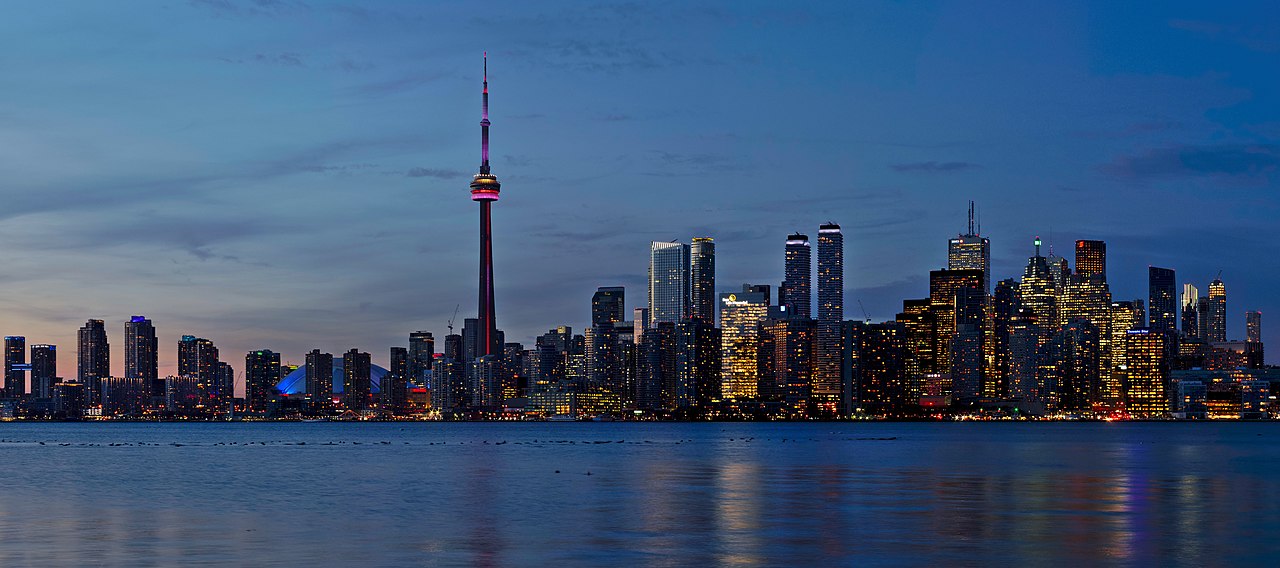
_(cropped).jpg/1280px-320_L1070205_27-020_(50882129891)_(cropped).jpg)