stringtranslate.com

Портал:Геология

Геологический портал

  • П:ГЕОЛ

Геология (от древнегреческого γῆ ( )  «земля» и λoγία ( -logía )  «изучение, рассуждение») — раздел естествознания , изучающий Землю и другие астрономические объекты , горные породы , из которых они состоят, и процессы, посредством которых они изменяются с течением времени. Современная геология существенно перекрывает все другие науки о Земле , включая гидрологию . Он интегрирован с наукой о системе Земли и планетарной наукой .

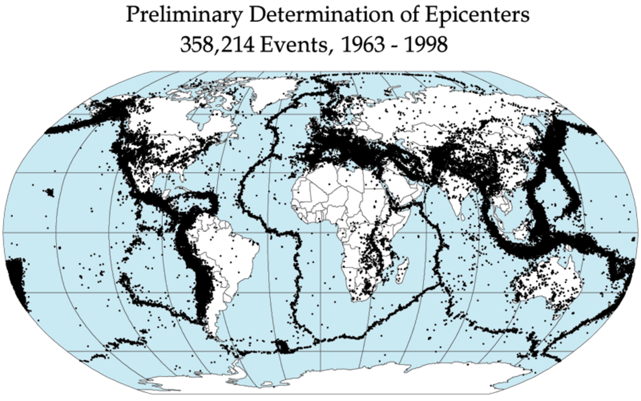
Геология описывает структуру Земли на ее поверхности и под ней, а также процессы, которые сформировали эту структуру. Геологи изучают минералогический состав горных пород, чтобы понять историю их формирования. Геология определяет относительный возраст горных пород, найденных в данном месте; геохимия (раздел геологии) определяет их абсолютный возраст . Объединив различные петрологические, кристаллографические и палеонтологические инструменты, геологи могут вести хронику геологической истории Земли в целом. Одним из аспектов является демонстрация возраста Земли . Геология предоставляет доказательства тектоники плит , эволюционной истории жизни и климата Земли в прошлом .

Геологи широко изучают свойства и процессы на Земле и других планетах земной группы. Геологи используют широкий спектр методов для понимания структуры и эволюции Земли, включая полевые исследования , описание горных пород , геофизические методы , химический анализ , физические эксперименты и численное моделирование . В практическом плане геология важна для разведки и эксплуатации полезных ископаемых и углеводородов , оценки водных ресурсов , понимания природных опасностей , устранения экологических проблем и предоставления информации о прошлых изменениях климата . Геология является основной академической дисциплиной , занимает центральное место в геологической инженерии и играет важную роль в геотехнической инженерии . ( Полная статья... )

Обновить, добавив новые элементы ниже (очистить)

Распознанный контент – загрузить новый пакет

Записи здесь состоят из хороших и избранных статей, которые соответствуют основному набору высоких редакционных стандартов.


  • Последняя фотография Джонстона, когда-либо сделанная за 13 часов до его смерти на месте извержения.

    Дэвид Александр Джонстон (18 декабря 1949 - 18 мая 1980) был вулканологом Геологической службы США (USGS), погибшим в результате извержения горы Сент-Хеленс в американском штате Вашингтон в 1980 году . Главный ученый группы наблюдения Геологической службы США, Джонстон погиб во время извержения, когда находился на наблюдательном пункте в шести милях (10 км) от него утром 18 мая 1980 года. Он был первым, кто сообщил об извержении, передав: «Ванкувер! Ванкувер». ! Это оно!" прежде чем его унесло боковым взрывом ; несмотря на тщательные поиски, тело Джонстона так и не было найдено, но работники шоссейной дороги штата обнаружили остатки его трейлера Геологической службы США в 1993 году.Карьера Джонстона привела его через Соединенные Штаты, где он изучал вулкан Августин на Аляске , вулканическое поле Сан-Хуан в Колорадо , и давно потухшие вулканы в Мичигане . Джонстон был дотошным и талантливым ученым, известным своими исследованиями вулканических газов и их связи с извержениями. Это, наряду с его энтузиазмом и позитивным настроем, снискало ему любовь и уважение многих коллег. После его смерти другие ученые превозносили его характер как устно, так и в посвящениях и письмах. Джонстон считал, что ученые должны делать все необходимое, в том числе идти на риск, чтобы защитить население от стихийных бедствий. Его работа и работа других ученых Геологической службы США убедили власти закрыть гору Сент-Хеленс для публики до извержения 1980 года. Они сохранили закрытие, несмотря на сильное давление с целью вновь открыть этот район; их работа спасла тысячи жизней. Его история переплелась с популярным представлением об извержениях вулканов и их угрозе обществу и стала частью истории вулканологии. На сегодняшний день Джонстон вместе со своим учеником Гарри Гликеном является одним из двух американских вулканологов, о которых известно, что они погибли в результате извержения вулкана. ( Полная статья... )


  • Тутупака, вид с южного направления.

    Tutupaca is a volcano in the region of Tacna in Peru. It is part of the Peruvian segment of the Central Volcanic Zone, one of several volcanic belts in the Andes. Tutupaca consists of three overlapping volcanoes formed by lava flows and lava domes made out of andesite and dacite, which grew on top of older volcanic rocks. The highest of these is usually reported to be 5,815 metres (19,078 ft) tall and was glaciated in the past.

    Several volcanoes in Peru have been active in recent times, including Tutupaca. Their volcanism is caused by the subduction of the Nazca Plate beneath the South America Plate. One of these volcanoes collapsed in historical time, probably in 1802, generating a large debris avalanche with a volume likely exceeding 0.6–0.8 cubic kilometres (0.14–0.19 cu mi) and a pyroclastic flow. The associated eruption was among the largest in Peru for which there are historical records. The volcano became active about 700,000 years ago, and activity continued into the Holocene, but whether there were historical eruptions was initially unclear; some eruptions were instead attributed to the less eroded Yucamane volcano. The Peruvian government plans to monitor the volcano for future activity. Tutupaca features geothermal manifestations with fumaroles and hot springs. (Full article...)
  • The Paleocene, (IPA: /ˈpæli.əsn, -i.-, ˈpli-/ PAL-ee-ə-seen, -⁠ee-oh-, PAY-lee-) or Palaeocene, is a geological epoch that lasted from about 66 to 56 million years ago (mya). It is the first epoch of the Paleogene Period in the modern Cenozoic Era. The name is a combination of the Ancient Greek παλαιός palaiós meaning "old" and the Eocene Epoch (which succeeds the Paleocene), translating to "the old part of the Eocene".

    The epoch is bracketed by two major events in Earth's history. The K–Pg extinction event, brought on by an asteroid impact (Chicxulub impact) and possibly volcanism (Deccan Traps), marked the beginning of the Paleocene and killed off 75% of species, most famously the non-avian dinosaurs. The end of the epoch was marked by the Paleocene–Eocene Thermal Maximum (PETM), which was a major climatic event wherein about 2,500–4,500 gigatons of carbon were released into the atmosphere and ocean systems, causing a spike in global temperatures and ocean acidification. (Full article...)
  • 🜨
    and ♁
    Earth is the third planet from the Sun and the only astronomical object known to harbor life. This is enabled by Earth being a water world, the only one in the Solar System sustaining liquid surface water. Almost all of Earth's water is contained in its global ocean, covering 70.8% of Earth's crust. The remaining 29.2% of Earth's crust is land, most of which is located in the form of continental landmasses within one hemisphere, Earth's land hemisphere. Most of Earth's land is somewhat humid and covered by vegetation, while large sheets of ice at Earth's polar deserts retain more water than Earth's groundwater, lakes, rivers and atmospheric water combined. Earth's crust consists of slowly moving tectonic plates, which interact to produce mountain ranges, volcanoes, and earthquakes. Earth has a liquid outer core that generates a magnetosphere capable of deflecting most of the destructive solar winds and cosmic radiation.

    Earth has a dynamic atmosphere, which sustains Earth's surface conditions and protects it from most meteoroids and UV-light at entry. It has a composition of primarily nitrogen and oxygen. Water vapor is widely present in the atmosphere, forming clouds that cover most of the planet. The water vapor acts as a greenhouse gas and, together with other greenhouse gases in the atmosphere, particularly carbon dioxide (CO2), creates the conditions for both liquid surface water and water vapor to persist via the capturing of energy from the Sun's light. This process maintains the current average surface temperature of 14.76 °C, at which water is liquid under atmospheric pressure. Differences in the amount of captured energy between geographic regions (as with the equatorial region receiving more sunlight than the polar regions) drive atmospheric and ocean currents, producing a global climate system with different climate regions, and a range of weather phenomena such as precipitation, allowing components such as nitrogen to cycle. (Full article...)
  • The eight planets of the Solar System with size to scale (up to down, left to right): Saturn, Jupiter, Uranus, Neptune (outer planets), Earth, Venus, Mars, and Mercury (inner planets)

    A planet is a large, rounded astronomical body that is neither a star nor its remnant. The best available theory of planet formation is the nebular hypothesis, which posits that an interstellar cloud collapses out of a nebula to create a young protostar orbited by a protoplanetary disk. Planets grow in this disk by the gradual accumulation of material driven by gravity, a process called accretion. The Solar System has at least eight planets: the terrestrial planets Mercury, Venus, Earth, and Mars, and the giant planets Jupiter, Saturn, Uranus, and Neptune.

    The word planet probably comes from the Greek planḗtai, meaning "wanderers". In antiquity, this word referred to the Sun, Moon, and five points of light visible by the naked eye that moved across the background of the stars—namely, Mercury, Venus, Mars, Jupiter, and Saturn. Planets have historically had religious associations: multiple cultures identified celestial bodies with gods, and these connections with mythology and folklore persist in the schemes for naming newly discovered Solar System bodies. Earth itself was recognized as a planet when heliocentrism supplanted geocentrism during the 16th and 17th centuries. (Full article...)
  • Life in the Ediacaran Period, as imagined by researchers in 1980.

    The Ediacaran (/ˌdiˈækərən/; formerly Vendian) biota is a taxonomic period classification that consists of all life forms that were present on Earth during the Ediacaran Period (c. 635–538.8 Mya). These were enigmatic tubular and frond-shaped, mostly sessile, organisms. Trace fossils of these organisms have been found worldwide, and represent the earliest known complex multicellular organisms. The term "Ediacara biota" has received criticism from some scientists due to its alleged inconsistency, arbitrary exclusion of certain fossils, and inability to be precisely defined.

    The Ediacaran biota may have undergone evolutionary radiation in a proposed event called the Avalon explosion, 575 million years ago. This was after the Earth had thawed from the Cryogenian period's extensive glaciation. This biota largely disappeared with the rapid increase in biodiversity known as the Cambrian explosion. Most of the currently existing body plans of animals first appeared in the fossil record of the Cambrian rather than the Ediacaran. For macroorganisms, the Cambrian biota appears to have almost completely replaced the organisms that dominated the Ediacaran fossil record, although relationships are still a matter of debate. (Full article...)

  • The 1867 Manhattan earthquake struck Riley County, Kansas, in the United States on April 24, 1867, at 20:22 UTC, or about 14:30 local time. The strongest earthquake to originate in the state, it measured 5.1 on a seismic scale that is based on an isoseismal map or the event's felt area. The earthquake's epicenter was near the town of Manhattan.

    The earthquake had a maximum perceived intensity of VII (Very strong) on the Mercalli intensity scale. It caused minor damage, reports of which were confined to Kansas, Iowa, and Missouri, according to the United States Geological Survey. Felt over an area of 200,000 square miles (520,000 km2), the earthquake reached the states of Indiana, Illinois, and possibly Ohio, though the latter reports have been questioned. (Full article...)

  • The Qayen earthquake, also known as the Ardekul or Qaen earthquake, struck northern Iran's Khorasan Province in the vicinity of Qaen on May 10, 1997 at 07:57 UTC (12:57 local time). The largest in the area since 1990, the earthquake registered 7.3 on the moment magnitude scale and was centered approximately 270 kilometers (170 mi) south of Mashhad on the village of Ardekul. The third earthquake that year to cause severe damage, it devastated the Birjand–Qayen region, killing 1,567 and injuring more than 2,300. The earthquake—which left 50,000 homeless and damaged or destroyed over 15,000 homes—was described as the deadliest of 1997 by the United States Geological Survey. Some 155 aftershocks caused further destruction and drove away survivors. The earthquake was later discovered to have been caused by a rupture along a fault that runs underneath the Iran–Afghanistan border.

    Damage was eventually estimated at $100 million, and many countries responded to the emergency with donations of blankets, tents, clothing, and food. Rescue teams were also dispatched to assist local volunteers in finding survivors trapped under the debris. The destruction around the earthquake's epicenter was, in places, almost total; this has been attributed to poor construction practices in rural areas, and imparted momentum to a growing movement for changes in building codes for earthquake-safe buildings. With 1 in 3,000 deaths in Iran attributable to earthquakes, a US geophysicist has suggested that a country-wide rebuilding program would be needed to address the ongoing public safety concerns. (Full article...)
  • Map of SSSIs in Cornwall within the UK
    Map of SSSIs in Cornwall within the UK

    There are 167 Sites of Special Scientific Interest (SSSIs) in Cornwall (including the Isles of Scilly). Cornwall, in the south-west of England, UK, has a population of 572,010 (2021) across an area of 3,545 km2 (875,988.6 acres), making it one of the least densely populated counties within England. The north coast of Cornwall falls on the Celtic Sea in the Atlantic Ocean, which also surrounds the Isles of Scilly, the south coast falls on the English Channel and the county is bounded by the River Tamar, forming the border with Devon, to the east. Cornish geology consists mainly of rocks from the Devonian and Carboniferous geological periods. Granite forms a large part of these, with mineralisations of tin, copper, lead and arsenic having been mined in the area. This gives rise to many distinct habitats, with strong marine influences, including sand dunes, rocky reefs, stacks and headlands as well as heathland, moorland and unusual river profiles.

    In England the body responsible for designating SSSIs is Natural England, which chooses a site "because of its flora, fauna, or geological or physiographical features". Natural England took over the role of designating and managing SSSIs from English Nature in October 2006 when it was formed from the amalgamation of English Nature, parts of the Countryside Agency and the Rural Development Service. Natural England, like its predecessor, uses the 1974–96 county system and as such the same approach is followed here, rather than adopting the current local government or ceremonial county boundaries. (Full article...)
  • Wide canyon with exposed red- and tan-colored rock
    The Grand Canyon from Navajo Point. The Colorado River is to the right and the North Rim is visible at all in the distance. The view shows nearly every sedimentary layer described in this article.


    The geology of the Grand Canyon area includes one of the most complete and studied sequences of rock on Earth. The nearly 40 major sedimentary rock layers exposed in the Grand Canyon and in the Grand Canyon National Park area range in age from about 200 million to nearly 2 billion years old. Most were deposited in warm, shallow seas and near ancient, long-gone sea shores in western North America. Both marine and terrestrial sediments are represented, including lithified sand dunes from an extinct desert. There are at least 14 known unconformities in the geologic record found in the Grand Canyon.

    Uplift of the region started about 75 million years ago during the Laramide orogeny; a mountain-building event that is largely responsible for creating the Rocky Mountains to the east. In total, the Colorado Plateau was uplifted an estimated 2 miles (3.2 km). The adjacent Basin and Range Province to the west started to form about 18 million years ago as the result of crustal stretching. A drainage system that flowed through what is today the eastern Grand Canyon emptied into the now lower Basin and Range province. The opening of the Gulf of California around 6 million years ago enabled a large river to cut its way northeast from the gulf. The new river captured the older drainage to form the ancestral Colorado River, which in turn started to form the Grand Canyon. (Full article...)

Важная статья

Важные статьи для понимания геологии.

Грязевые пятна выстроились над вулканической трещиной в Хвераронде , Исландия.
Грязевой котел , или грязевой бассейн , представляет собой разновидность кислого горячего источника или фумаролы с ограниченным количеством воды. Обычно он принимает форму лужи бурлящей грязи в результате того, что кислота и микроорганизмы разлагают окружающую породу на глину и грязь. ( Полная статья... )

Связанные порталы

Втягиваться

Чтобы получить ресурсы для редактора и сотрудничать с другими редакторами в улучшении статей Википедии, посвященных геологии, посетите WikiProject Geology .

Избранная биография

Избранные биографические статьи в области геологии

Треугольник Дикинсона QFL
Уильям Ричард Дикинсон (26 октября 1931 — 21 июля 2015) был почётным профессором геонаукв Университете Аризоны и членом Национальной академии наук США . До прихода в Университет Аризоны Дикинсон был профессором Стэнфордского университета . Он поступил на факультет Университета А в 1979 году. ( Полная статья... )

Вы знали

Знали ли вы это о геологии?

Топ-10 WikiProject Geology Популярные статьи месяца

Следующие статьи, связанные с геологией, являются наиболее посещаемыми статьями WikiProject Geology . Полный список см. в Википедии: WikiProject Geology/Популярные страницы .

Избранные фотографии

Нажмите, чтобы увеличить и просмотреть описание.

Основные статьи

Категории

Выберите [►] для просмотра подкатегорий.

Выбранные фотографии

Связанный Викимедиа

Следующие дочерние проекты Фонда Викимедиа предоставляют дополнительную информацию по этому вопросу:

  • Commons
    Бесплатный медиа-репозиторий
  • Wikibooks
    Бесплатные учебники и пособия
  • Викиданные
    Бесплатная база знаний
  • Викиновости
    Новости бесплатного контента
  • Wikiquote
    Сборник цитат
  • Wikisource
    Библиотека бесплатного контента
  • Викиверситет
    Бесплатные инструменты обучения
  • Wikivoyage
    Бесплатный путеводитель
  • Викисловарь
    , словарь и тезаурус

Откройте для себя Википедию с помощью порталов

Очистить кэш сервера