
Южная Америка — континент [h], полностью расположенный в Западном полушарии [i] и в основном в Южном полушарии , с существенно меньшей частью в Северном полушарии . Его также можно описать как южный субрегион Америки .
Южная Америка омывается на западе Тихим океаном , а на севере и востоке — Атлантическим океаном ; на северо-западе лежат Северная Америка и Карибское море .
Континент включает в себя двенадцать суверенных государств: Аргентина , Боливия , Бразилия , Чили , Колумбия , Эквадор , Гайана , Парагвай , Перу , Суринам , Уругвай и Венесуэла ; две зависимые территории : Фолклендские острова и Южная Георгия и Южные Сандвичевы острова ; [j] и одну внутреннюю территорию : Французская Гвиана . [k]
Территории островов ABC Королевства Нидерландов (расположены к северу от Венесуэлы в Западной части Карибского моря), Британские заморские территории Вознесения , Святой Елены и Тристан-да-Кунья (расположены в Южной Атлантике), остров Буве ( зависимая территория Норвегии ) , Панама и островная Республика Тринидад и Тобаго также могут считаться частями Южной Америки.
Южная Америка имеет площадь 17 840 000 квадратных километров (6 890 000 квадратных миль). Ее население по состоянию на 2021 год [update]оценивается в более чем 434 миллиона человек. [1] [2] Южная Америка занимает четвертое место по площади (после Азии, Африки и Северной Америки) и пятое место по численности населения (после Азии, Африки, Европы и Северной Америки). Бразилия является самой густонаселенной страной Южной Америки, в ней проживает почти половина населения континента, за ней следуют Колумбия, Аргентина, Венесуэла и Перу. В последние десятилетия Бразилия также генерировала половину ВВП континента и стала первой региональной державой континента. [8]
Большая часть населения проживает вблизи западного или восточного побережья континента, в то время как внутренние районы и дальний юг заселены мало. География западной части Южной Америки определяется горами Анды ; в противоположность этому, восточная часть включает как высокогорные регионы, так и обширные низменности, где протекают такие реки, как Амазонка , Ориноко и Парана . Большая часть континента лежит в тропиках, за исключением значительной части Южного конуса, расположенного в средних широтах .
Культурный и этнический облик континента берет свое начало во взаимодействии коренных народов с европейскими завоевателями и иммигрантами и, более локально, с африканскими рабами . Учитывая долгую историю колониализма , подавляющее большинство южноамериканцев говорят на испанском или португальском языках , а общества и государства богаты западными традициями . По сравнению с Европой, Азией и Африкой, после 1900 года Южная Америка была мирным континентом с небольшим количеством войн, [9] [10] [l] хотя высокие показатели насильственных преступлений остаются проблемой в некоторых странах. [12] [13]

Южная Америка занимает южную часть Америки. Континент в целом ограничен на северо-западе водоразделом Дарьен вдоль границы Колумбии и Панамы , хотя некоторые могут считать, что граница проходит по Панамскому каналу . Геополитически [14] и географически вся Панама — включая сегмент к востоку от Панамского канала на перешейке — обычно включается только в Северную Америку [15] [16] [17] и в число стран Центральной Америки . [18] [19] Почти вся материковая часть Южной Америки расположена на Южно-Американской плите .
Южная Америка является родиной нескольких превосходных степеней, в том числе, самый высокий в мире непрерывный водопад Анхель в Венесуэле; самый высокий однокаскадный водопад Кайетур в Гайане; самая большая река по объему воды, река Амазонка ; самая длинная горная цепь, Анды (чьей самой высокой точкой является Аконкагуа высотой 6962 м или 22 841 фут); самое сухое неполярное место на Земле, пустыня Атакама ; [20] [21] [22] самое влажное место на Земле, Лопес-де-Микай в Колумбии; самый большой тропический лес, тропические леса Амазонки ; самая высокогорная столица, Ла-Пас , Боливия ; самое высокогорное в мире судоходное озеро, озеро Титикака ; и, за исключением исследовательских станций в Антарктиде , самое южное постоянно населенное сообщество в мире, Пуэрто-Торо , Чили.
Основными минеральными ресурсами Южной Америки являются золото, серебро, медь, железная руда, олово и нефть. Эти ресурсы приносили высокий доход ее странам, особенно во время войны или быстрого экономического роста промышленно развитых стран в других местах. Однако концентрация на производстве одного или нескольких основных экспортных товаров часто препятствовала развитию и диверсификации ее экономики. Колебания цен на товары на международных рынках исторически приводили к крупным взлетам и падениям, подъемам и спадам в экономике южноамериканских государств, часто вызывая политическую нестабильность. [23] Это привело к призывам диверсифицировать производство и увеличить торговлю внутри самой Южной Америки. [23]
Бразилия — самая большая страна в Южной Америке, занимающая чуть меньше половины площади континента и охватывающая около половины его населения. [24] Остальные страны и территории разделены на четыре субрегиона : Андские государства, Карибская Южная Америка , Гвианы и Южный Конус . [25]

Физиографически Южная Америка также включает некоторые из близлежащих островов. Голландские острова ABC ( Аруба , Бонайре и Кюрасао ), острова Тринидад и Тобаго ( остров Тринидад и остров Тобаго и т. д.), штат Нуэва-Эспарта и федеральные владения Венесуэлы находятся в северной части континентального шельфа Южной Америки и иногда считаются частями континента. Геополитически все островные страны и территории в Карибском море, как правило, группируются как субрегион Северной Америки. Напротив, остров Авес (управляемый Венесуэлой ) и архипелаг Сан-Андрес, Провиденсия и Санта-Каталина ( остров Сан-Андрес , остров Провиденсия и остров Санта-Каталина и т. д., управляемые Колумбией ) являются политически частями стран Южной Америки, но физиографически частями Северной Америки. [17] [26] [27]
Другие острова, часто ассоциируемые с геополитической Южной Америкой, — это архипелаг Чилоэ и остров Робинзона Крузо (оба находятся под управлением Чили), остров Пасхи (культурно часть Океании, также находится под управлением Чили), [28] Галапагосские острова (управление Эквадора , иногда считаются частью Океании), [28] [29] [30] и Огненная Земля (разделена между Аргентиной и Чили). В Атлантическом океане Бразилия управляет Фернанду-ди-Норонья , Триндади и Мартим-Ваз , а также архипелагом Святого Петра и Святого Павла , в то время как Фолклендские острова (исп. Islas Malvinas ), Южная Георгия и Южные Сандвичевы острова ( биогеографически и гидрологически связанные с Антарктидой) [31] управлялись как две британские заморские территории под управлением Короны , суверенитет которой над островами оспаривается Аргентиной .
Изолированный вулканический остров на Южно-Американской плите , остров Вознесения геологически является частью Южной Америки. [32] Управляемый как зависимая территория островов Святой Елены, Вознесения и Тристан-да-Кунья , остров геополитически является частью Африки.

В Южной Америке присутствуют все основные климатические зоны мира. [34]
Распределение средних температур в регионе представляет собой постоянную закономерность от 30° широты к югу , когда изотермы все больше и больше путают с градусами широты. [35]
В умеренных широтах зима и лето мягче, чем в Северной Америке. Это связано с тем, что самая обширная часть континента находится в экваториальной зоне (в регионе больше экваториальных равнин, чем в любом другом регионе), [35] поэтому Южный конус испытывает больше океанического влияния, что смягчает круглогодичные температуры.
Среднегодовые температуры в бассейне Амазонки колеблются около 27 °C (81 °F), с низкими термическими амплитудами и высокими показателями осадков. Между озером Маракайбо и устьем Ориноко преобладает экваториальный климат конголезского типа, который также включает части бразильской территории. [35]
Восточно-центральное бразильское плато имеет влажный и теплый тропический климат. Северные и восточные части аргентинских пампасов имеют влажный субтропический климат с сухой зимой и влажным летом китайского типа, в то время как западные и восточные хребты имеют субтропический климат динарского типа. В самых высоких точках Андского региона климат более холодный, чем тот, который встречается в самой высокой точке норвежских фьордов. На андийских плато преобладает теплый климат, хотя он смягчается высотой, в то время как в прибрежной полосе наблюдается экваториальный климат гвинейского типа. От этой точки до севера чилийского побережья появляются последовательно средиземноморский океанический климат , умеренный бретонского типа и, уже на Огненной Земле , холодный климат сибирского типа. [35]

Распределение осадков связано с режимом ветров и воздушных масс. В большей части тропического региона к востоку от Анд ветры, дующие с северо-востока, востока и юго-востока, переносят влагу из Атлантики, вызывая обильные осадки. Однако из-за постоянно сильного сдвига ветра и слабой внутритропической зоны конвергенции южноатлантические тропические циклоны редки. [36] В Ориноко-Льянос и на плато Гвиана уровень осадков варьируется от умеренного до высокого. Тихоокеанское побережье Колумбии и северный Эквадор являются дождливыми регионами, причем Чоко в Колумбии является самым дождливым местом в мире наряду с северными склонами индийских Гималаев. [37] Пустыня Атакама, вдоль этого участка побережья, является одним из самых засушливых регионов в мире. Центральная и южная части Чили подвержены внетропическим циклонам , а большая часть аргентинской Патагонии является пустыней . В пампасах Аргентины, Уругвая и юга Бразилии осадки умеренные, с хорошим распределением осадков в течение года. Умеренно сухие условия Чако противостоят интенсивным осадкам восточного региона Парагвая. На полузасушливом побережье северо-востока Бразилии дожди связаны с муссонным режимом. [35]
Важными факторами в определении климата являются морские течения, такие как течение Гумбольдта и Фолклендские острова . Экваториальное течение Южной Атлантики достигает побережья Северо-Востока и там разделяется на два других: течение Бразилии и прибрежное течение, которое течет на северо-запад к Антильским островам , где оно движется в северо-восточном направлении, образуя таким образом самое важное и известное океаническое течение в мире — Гольфстрим . [35] [38]
Южная Америка является одним из самых биологически разнообразных континентов на Земле. Она является домом для многих уникальных видов животных, включая ламу , анаконду , пиранью , ягуара , викунью и тапира , а также для одного из крупнейших известных насекомых в мире, жука-титана . Тропические леса Амазонки обладают высоким биоразнообразием , при этом, по оценкам, в Бразилии обитает 10% видов Земли . [39] 83% крупных млекопитающих Южной Америки ( мегафауна ) вымерли в конце плейстоцена около 11 000 лет назад в ходе четвертичного вымирания , одного из самых масштабных среди всех континентов, среди жертв были саблезубые кошки , наземные ленивцы , глиптодонты , гомфотерии , лошадиные Hippidion и Equus neogeus , а также все оставшиеся южноамериканские местные копытные . [40]
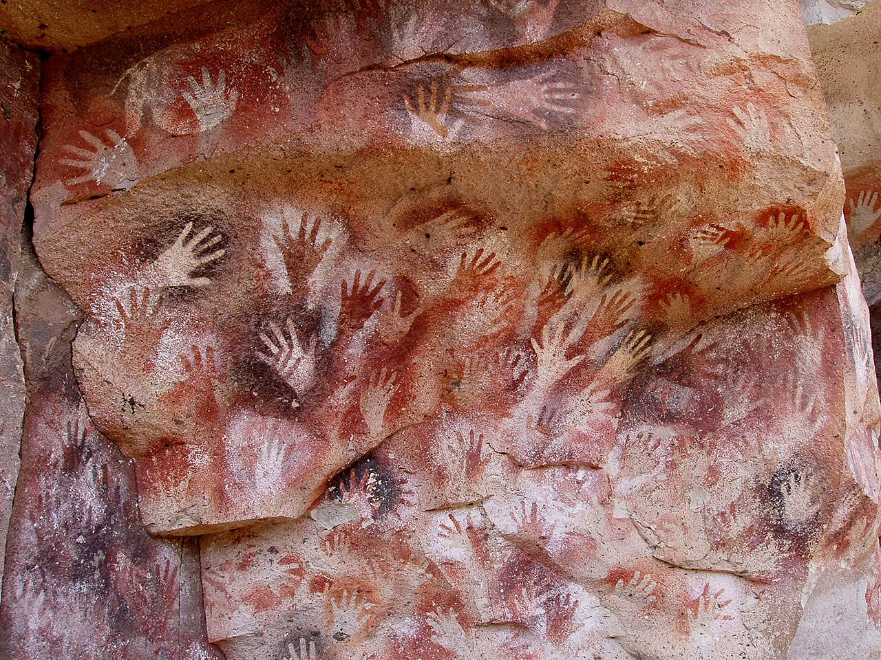
Считается, что Южная Америка была впервые заселена людьми, когда они пересекли Берингов мост (ныне Берингов пролив ) по крайней мере 15 000 лет назад с территории современной России. Они мигрировали на юг через Северную Америку и в конечном итоге достигли Южной Америки через Панамский перешеек .
Среди древнейших свидетельств присутствия человека в Южной Америке — стоянка Монте-Верде II в Чили, предположительно датируемая примерно 14 500 лет назад. [41] Примерно 13 000 лет назад стиль наконечника снаряда «Рыбий хвост» получил широкое распространение по всей Южной Америке, а его исчезновение около 11 000 лет назад совпало с исчезновением мегафауны Южной Америки. [42] Кукуруза появилась на севере Южной Америки примерно 6 000 лет назад. [43]
К 2000 году до нашей эры многие аграрные общины были расселены по Андам и прилегающим регионам. Рыболовство стало широко распространенной практикой вдоль побережья, помогая сделать рыбу основным источником пищи. В это время также были разработаны ирригационные системы, что способствовало возникновению аграрного общества . [44]
Южноамериканские культуры начали одомашнивать лам , викуний , гуанако и альпак в высокогорьях Анд около 3500 г. до н. э. Помимо использования в качестве источников мяса и шерсти, эти животные использовались для перевозки грузов. [44]

Развитие растениеводства и последующее появление постоянных поселений человека способствовали возникновению многочисленных и перекрывающихся цивилизаций в Южной Америке.
Одна из самых ранних известных южноамериканских цивилизаций находилась в Караль-Супе , на центральном перуанском побережье. Хотя это была докерамическая культура, монументальная архитектура Караль-Супе создала один из первых городов мира, обычно датируемый примерно 3500 годом до нашей эры, в Уариканге в районе Форталезы , современник пирамид Древнего Египта , одной из старейших известных цивилизаций в Америке и одного из шести мест, где цивилизация отдельно зародилась в древнем мире. [45] Правящий класс Караль-Супе создал торговую сеть и развил сельское хозяйство, а затем , согласно некоторым оценкам и археологическим находкам, к 900 году до нашей эры последовал Чавин . Артефакты были найдены в месте под названием Чавин-де-Уантар в современном Перу на высоте 3177 метров (10 423 фута). Цивилизация Чавин существовала с 900 года до нашей эры по 300 год до нашей эры.
На центральном побережье Перу, примерно в начале 1-го тысячелетия н. э., процветали культуры Моче (100 г. до н. э. — 700 г. н. э., на северном побережье Перу), Паракас и Наска (400 г. до н. э. — 800 г. н. э., Перу) с централизованными государствами с постоянным ополчением, улучшающими сельское хозяйство посредством орошения и новых стилей керамического искусства. На Альтиплано Тиауанако или Тиуанако (100 г. до н. э. — 1200 г. н. э., Боливия) управляли большой торговой сетью, основанной на религии.
Около VII века Тиауанако и империя Уари или Уари ( 600–1200 гг., Центральное и Северное Перу) распространили свое влияние на весь Андский регион, навязав урбанизм Уари и религиозную иконографию Тиауанако.
Муиски были главной коренной цивилизацией на территории современной Колумбии. Они основали Конфедерацию муисков , состоящую из многих кланов, или касиказгос , которые имели свободную торговую сеть между собой. Многие были ювелирами и фермерами.
Другие важные доколумбовые культуры включают: каньяри (на юге центрального Эквадора), империю чиму (1300–1470, северное побережье Перу), чачапойя и королевства аймара (1000–1450, Западная Боливия и юг Перу). Имея свою столицу в великом городе Куско , цивилизация инков доминировала в регионе Анд с 1438 по 1533 год. Известная как Tawantin suyu и «земля четырех регионов» на языке кечуа , империя инков была весьма самобытной и развитой. Правление инков распространялось почти на сотню языковых или этнических общин, около девяти-четырнадцати миллионов человек, связанных дорожной системой протяженностью 25 000 километров . Города были построены с точной, непревзойденной каменной кладкой, возведенной на многих уровнях горной местности. Террасное земледелие было полезной формой сельского хозяйства.
Мапуче в Центральном и Южном Чили сопротивлялись европейским и чилийским поселенцам, ведя Араукскую войну , продолжавшуюся более 300 лет.
.jpg/1280px-Desembarque_de_Pedro_%C3%81lvares_Cabral_em_Porto_Seguro_em_1500_by_Oscar_Pereira_da_Silva_(1865%E2%80%931939).jpg)
В 1494 году Португалия и Испания, две великие морские европейские державы того времени, в ожидании открытия новых земель на западе подписали Тордесильясский договор , в котором они согласились, при поддержке Папы, что все земли за пределами Европы должны быть исключительной дуополией между двумя странами. [46]

Договор установил воображаемую линию вдоль меридиана с севера на юг в 370 лигах к западу от островов Зеленого Мыса , примерно 46° 37' з. д. Согласно договору, все земли к западу от линии (известно, что они включают большую часть южноамериканской земли) принадлежали Испании, а все земли к востоку — Португалии. Поскольку в то время точные измерения долготы были невозможны, линия не была строго соблюдена, что привело к португальской экспансии Бразилии через меридиан.
Начиная с 1530-х годов, население и природные ресурсы Южной Америки неоднократно эксплуатировались иностранными конкистадорами , сначала из Испании, а затем из Португалии. Эти конкурирующие колониальные нации объявили землю и ресурсы своей собственностью и разделили ее на колонии.
Европейские инфекционные заболевания ( оспа , грипп , корь и тиф ), к которым у коренного населения не было иммунитета, вызвали масштабную депопуляцию коренного населения под контролем испанцев. Системы принудительного труда, такие как асьенды и горнодобывающая промышленность mit'a , также способствовали депопуляции. После этого на смену им быстро привезли порабощенных африканцев , у которых развился иммунитет к этим болезням.

Испанцы были привержены идее обращения своих коренных подданных в христианство и быстро очистили любые местные культурные практики, которые препятствовали этой цели; однако многие первоначальные попытки в этом направлении были лишь частично успешными, поскольку коренные группы просто смешивали католицизм со своими устоявшимися верованиями и практиками. Более того, испанцы привнесли свой язык в той же степени, в какой они сделали это со своей религией, хотя евангелизация Римско-католической церковью кечуа , аймара и гуарани фактически способствовала непрерывному использованию этих местных языков, хотя и только в устной форме.
В конце концов, аборигены и испанцы скрестились, образовав класс метисов . В начале многие метисы Андского региона были потомками матерей-индеанок и отцов-испанцев. После обретения независимости большинство метисов имели отцов-аборигенов и матерей-европейок или метисок.
Многие местные произведения искусства считались языческими идолами и были уничтожены испанскими исследователями; это включало множество золотых и серебряных скульптур и других артефактов, найденных в Южной Америке, которые были переплавлены перед их транспортировкой в Испанию или Португалию. Испанцы и португальцы принесли западноевропейский архитектурный стиль на континент и помогли улучшить инфраструктуру, такую как мосты, дороги и канализационную систему городов, которые они открыли или завоевали. Они также значительно расширили экономические и торговые отношения не только между старым и новым светом, но и между различными регионами и народами Южной Америки. Наконец, с распространением португальского и испанского языков многие культуры, которые ранее были разделены, объединились через латиноамериканскую.
Гайана была первоначально колонизирована голландцами, прежде чем перейти под контроль Великобритании , хотя был короткий период во время Наполеоновских войн , когда она была оккупирована французами . Регион был первоначально разделен между голландцами, французами и британцами, прежде чем полностью перейти под контроль Великобритании.
Суринам был впервые исследован испанцами в 16 веке, а затем заселен англичанами в середине 17 века. Он стал голландской колонией в 1667 году. [47]

Коренные народы Америки в различных европейских колониях были вынуждены работать на европейских плантациях и шахтах; вместе с порабощенными африканцами, которые также были завезены в последующие столетия через работорговлю . Европейские колонисты сильно зависели от труда коренных народов на начальных этапах поселения для поддержания натурального хозяйства, и туземцы часто захватывались экспедициями. Импорт африканских рабов начался в середине 16-го века, но порабощение коренных народов продолжалось и в 17-м и 18-м веках. Атлантическая работорговля привела порабощенных африканцев в основном в южноамериканские колонии, начиная с португальцев с 1502 года. [48] Основными пунктами назначения на этом этапе были карибские колонии и Бразилия, поскольку европейские страны создавали экономически зависимые от рабов колонии в Новом Свете . Почти 40% всех африканских рабов, переправленных в Америку, отправлялись в Бразилию. По оценкам, в период с 1501 по 1866 год в Бразилию прибыло 4,9 миллиона рабов из Африки. [49] [50]
В отличие от других европейских колоний в Америке, которые в основном использовали труд африканских рабов, испанские колонисты в основном порабощали коренных американцев. В 1750 году португальская корона отменила рабство коренных народов в колониальной Бразилии , полагая, что они непригодны для труда и менее эффективны, чем порабощенные африканцы. Порабощенных африканцев привозили в Америку на невольничьих кораблях , в нечеловеческих условиях и с жестоким обращением, а тех, кто выживал, продавали на невольничьих рынках . [51] После обретения независимости все страны Южной Америки некоторое время сохраняли рабство. Первой страной Южной Америки, отменившей рабство, была Чили в 1823 году, Уругвай в 1830 году, Боливия в 1831 году, Гайана в 1833 году, Колумбия и Эквадор в 1851 году, Аргентина в 1853 году, Перу и Венесуэла в 1854 году, Суринам в 1863 году, Парагвай в 1869 году, а в 1888 году Бразилия стала последней страной Южной Америки и последней страной в западном мире, отменившей рабство. [52]
Европейская полуостровная война (1807–14), театр наполеоновских войн , изменила политическую ситуацию в испанских и португальских колониях. Сначала Наполеон вторгся в Португалию, но Дом Браганса избежал плена, сбежав в Бразилию . Наполеон захватил короля Фердинанда VII Испанского и назначил вместо него своего брата. Это назначение вызвало народное сопротивление, которое создало Хунты для правления от имени захваченного короля.

Однако многие города в испанских колониях считали себя в равной степени уполномоченными назначать местные Хунты, подобные тем, что были в Испании. Это положило начало испано-американским войнам за независимость между патриотами, которые продвигали такую автономию, и роялистами , которые поддерживали испанскую власть над Америкой. Хунты, как в Испании, так и в Америке, продвигали идеи Просвещения . Через пять лет после начала войны Фердинанд VII вернулся на трон и начал Абсолютистскую реставрацию , поскольку роялисты одержали верх в конфликте.
Независимость Южной Америки была обеспечена Симоном Боливаром (Венесуэла) и Хосе де Сан Мартином (Аргентина), двумя самыми важными Освободителями . Боливар возглавил великое восстание на севере, затем повел свою армию на юг к Лиме , столице вице-королевства Перу . Тем временем Сан Мартин повел армию через Анды вместе с чилийскими эмигрантами и освободил Чили. Он организовал флот, чтобы добраться до Перу по морю, и искал военной поддержки у различных повстанцев из вице-королевства Перу. В 1822 году эти двое мужчин встретились на конференции в Гуаякиле в Эквадоре, где им не удалось договориться о стратегиях управления для освобожденных стран. [53] Два года спустя войска Боливара разбили испанцев в битве при Аякучо , обеспечив независимость Перу и остальной части Южной Америки. [53]
В португальском королевстве Бразилия дон Педру I (также Педру IV Португальский), сын португальского короля дона Жуана VI , провозгласил в 1822 году независимое королевство Бразилия , которое позже стало Бразильской империей . Несмотря на лояльность португальцев гарнизонов в Баия , Сисплатина и Пара , независимость была дипломатически принята Португалией в 1825 году при условии выплаты Бразилией высокой компенсации при посредничестве Соединенного Королевства.


Новые независимые государства начали процесс фрагментации с несколькими гражданскими и международными войнами. Однако он не был таким сильным, как в Центральной Америке. Некоторые страны, созданные из провинций более крупных стран, оставались таковыми вплоть до современных времен (например, Парагвай или Уругвай), в то время как другие были отвоеваны и повторно включены в свои бывшие страны (например, Республика Энтре-Риос и Республика Риогранде ).
Первая сепаратистская попытка была предпринята в 1820 году аргентинской провинцией Энтре-Риос во главе с каудильо . [54] Несмотря на «Республику» в названии, генерал Рамирес , ее каудильо, на самом деле никогда не намеревался объявлять независимый Энтре-Риос. Скорее, он делал политическое заявление в противовес монархическим и централистским идеям, которые тогда пронизывали политику Буэнос-Айреса . «Страна» была повторно включена в Соединенные провинции в 1821 году.
В 1825 году провинция Сисплатина объявила о своей независимости от Бразильской империи , что привело к Сисплатинской войне между имперцами и аргентинцами из Соединенных провинций Рио-де-ла-Плата за контроль над регионом. Три года спустя Соединенное Королевство вмешалось в этот вопрос, объявив ничью и создав на территории бывшей Сисплатины новое независимое государство: Восточную Республику Уругвай .
Позже в 1836 году, когда Бразилия переживала хаос регентства, Риу-Гранди-ду-Сул провозгласил свою независимость, мотивированную налоговым кризисом. С ожиданием коронации Педру II на трон Бразилии, страна смогла стабилизироваться и бороться с сепаратистами, к которым провинция Санта-Катарина присоединилась в 1839 году. Конфликт завершился процессом компромисса, в результате которого и Республика Рио-Гранде , и Республика Жулиана были реинкорпорированы в качестве провинций в 1845 году. [55] [56]

Перуано -боливийская конфедерация , недолговечный союз Перу и Боливии, была заблокирована Чили в Войне конфедерации (1836–39) и снова во время войны на Тихом океане (1879–83). Парагвай был фактически уничтожен Аргентиной, Бразилией и Уругваем в Парагвайской войне .
Несмотря на испано-американские войны за независимость и бразильскую войну за независимость , новые нации быстро начали страдать от внутренних конфликтов и войн между собой. Большинство границ 1810 года, которые страны первоначально приняли по принципу uti possidetis iuris, к 1848 году были либо изменены войной, либо оспаривались. [57]
В 1825 году провозглашение независимости Сисплатины привело к Сисплатинской войне между историческими соперниками — Бразильской империей и Соединёнными провинциями Рио-де-ла-Плата , предшественницей Аргентины. Результатом стала тупиковая ситуация, закончившаяся тем, что британское правительство организовало независимость Уругвая. Вскоре после этого другая бразильская провинция провозгласила свою независимость, что привело к войне Рагамаффинов , в которой Бразилия победила.
Между 1836 и 1839 годами разразилась Война Конфедерации между недолговечным Перуано-Боливийским союзом и Чили при поддержке Аргентинской конфедерации . Война велась в основном на территории самого Перу и закончилась поражением Конфедерации, роспуском Конфедерации и аннексией многих территорий Аргентиной.
Между тем, гражданские войны в Аргентине терзали Аргентину с момента обретения ею независимости. Конфликт в основном происходил между теми, кто защищал централизацию власти в Буэнос-Айресе, и теми, кто защищал конфедерацию. В этот период можно сказать, что «было две аргентинки»: Аргентинская конфедерация и Аргентинская республика . В то же время политическая нестабильность в Уругвае привела к гражданской войне в Уругвае между основными политическими фракциями страны. Вся эта нестабильность в регионе Платина мешала целям других стран, таких как Бразилия, которая вскоре была вынуждена принять чью-либо сторону. В 1851 году Бразильская империя , поддерживая централизующих унитариев, и уругвайское правительство вторглись в Аргентину и свергли каудильо Хуана Мануэля Росаса , который правил конфедерацией железной рукой. Хотя Платинская война не положила конец политическому хаосу и гражданской войне в Аргентине, она принесла временный мир в Уругвай, где победила фракция «Колорадос» при поддержке Бразилии , Великобритании , Франции и Унитарной партии Аргентины. [58]
Мир продлился недолго: в 1864 году уругвайские фракции снова столкнулись друг с другом в Уругвайской войне . Бланкос , поддерживаемые Парагваем, начали нападать на бразильских и аргентинских фермеров вблизи границ. Империя предприняла первую попытку урегулировать спор между Бланкос и Колорадос, но безуспешно. В 1864 году, после того как бразильский ультиматум был отклонен, имперское правительство заявило, что бразильские военные начнут репрессии. Бразилия отказалась признать формальное состояние войны, и на протяжении большей части своего срока уругвайско-бразильский вооруженный конфликт был необъявленной войной, которая привела к свержению Бланкос и повторному приходу к власти пробразильских Колорадос . Это разозлило парагвайское правительство, которое еще до окончания войны вторглось в Бразилию, начав самую длительную и кровопролитную межгосударственную войну в истории Латинской Америки: Парагвайскую войну. [59]

Парагвайская война началась, когда парагвайский диктатор Франсиско Солано Лопес приказал вторгнуться в бразильские провинции Мату-Гросу и Риу-Гранди-ду-Сул . Его попытка пересечь территорию Аргентины без одобрения Аргентины привела к тому, что пробразильское правительство Аргентины вступило в войну. Пробразильское правительство Уругвая выразило свою поддержку, отправив войска. В 1865 году три страны подписали Договор о Тройственном союзе против Парагвая. В начале войны парагвайцы взяли на себя инициативу, одержав несколько побед, пока Тройственный союз не организовался, чтобы отразить захватчиков и эффективно сражаться. Это был второй опыт тотальной войны в мире после Гражданской войны в США . Это было признано величайшим военным усилием в истории всех стран-участниц, длившимся почти 6 лет и закончившимся полным опустошением Парагвая. Страна потеряла 40% своей территории в пользу Бразилии и Аргентины и потеряла 60% своего населения, включая 90% мужчин. Диктатор Лопес был убит в бою, и было сформировано новое правительство в союзе с Бразилией, которая сохраняла оккупационные силы в стране до 1876 года. [60]
Последняя южноамериканская война в 19 веке была Тихоокеанской войной с Боливией и Перу с одной стороны и Чили с другой. В 1879 году война началась с того, что чилийские войска заняли боливийские порты, после чего Боливия объявила войну Чили, что привело к заключению союзного договора с Перу. Боливийцы были полностью разгромлены в 1880 году, а Лима была оккупирована в 1881 году. Мир с Перу был подписан в 1883 году, а перемирие с Боливией было подписано в 1884 году. Чили аннексировала территории обеих стран, оставив Боливию без выхода к морю . [61]

In the new century, as wars became less violent and less frequent, Brazil entered into a small conflict with Bolivia for the possession of the Acre, which was acquired by Brazil in 1902. In 1917 Brazil declared war on the Central Powers, joined the allied side in the First World War and sent a small fleet to the Mediterranean Sea and some troops to be integrated with the British and French forces in the region. Brazil was the only South American country that participated in the First World War.[62][63] Later in 1932 Colombia and Peru entered a short armed conflict for territory in the Amazon. In the same year Paraguay declared war on Bolivia for possession of the Chaco, in a conflict that ended three years later with Paraguay's victory. Between 1941 and 1942 Peru and Ecuador fought for territories claimed by both that were annexed by Peru, usurping Ecuador's frontier with Brazil.[64]
Also in this period, the first major naval battle of World War II took place in the South Atlantic close to the continental mainland: the Battle of the River Plate, between a British cruiser squadron and a German pocket battleship.[65] The Germans still made numerous attacks on Brazilian ships on the coast, causing Brazil to declare war on the Axis powers in 1942, being the only South American country to fight in this war (and in both World Wars). Brazil sent naval and air forces to combat German and Italian submarines off the continent and throughout the South Atlantic, in addition to sending an expeditionary force to fight in the Italian Campaign.[66][67]
A brief war was fought between Argentina and the UK in 1982, following an Argentine invasion of the Falkland Islands, which ended with an Argentine defeat. The last international war to be fought on South American soil was the 1995 Cenepa War between Ecuador and the Peru along their mutual border.
Wars became less frequent in the 20th century, with Bolivia-Paraguay and Peru-Ecuador fighting the last inter-state wars. Early in the 20th century, the three wealthiest South American countries engaged in a vastly expensive naval arms race which began after the introduction of a new warship type, the "dreadnought". At one point, the Argentine government was spending a fifth of its entire yearly budget for just two dreadnoughts, a price that did not include later in-service costs, which for the Brazilian dreadnoughts was sixty percent of the initial purchase.[68][69]

The continent became a battlefield of the Cold War in the late 20th century. Some democratically elected governments of Argentina, Brazil, Chile, Uruguay and Paraguay were overthrown or displaced by military dictatorships in the 1960s and 1970s. To curtail opposition, their governments detained tens of thousands of political prisoners, many of whom were tortured or killed on inter-state collaboration. Economically, they began a transition to neoliberal economic policies. They placed their own actions within the US Cold War doctrine of "National Security" against internal subversion. Throughout the 1980s and 1990s, Peru suffered from an internal conflict.
In 1982, Argentina invaded the Falkland Islands, a British dependent territory. The Falklands War began and 74 days later Argentine forces surrendered.[70]
Colombia has had an ongoing, though diminished internal conflict, which started in 1964 with the creation of Marxist guerrillas (FARC-EP) and then involved several illegal armed groups of leftist-leaning ideology as well as the private armies of powerful drug lords. Many of these are now defunct, and only a small portion of the ELN remains, along with the stronger, though also greatly reduced, FARC.
Revolutionary movements and right-wing military dictatorships became common after World War II, but since the 1980s, a wave of democratization passed through the continent, and democratic rule is widespread now.[71] Nonetheless, allegations of corruption are still very common, and several countries have developed crises which have forced the resignation of their governments, although, on most occasions, regular civilian succession has continued.
International indebtedness became a significant problem in the late 1980s, and some countries, despite having strong democracies, have not developed political institutions capable of handling such crises without resorting to unorthodox economic policies. This was illustrated by Argentina's default in the early 21st century.[72] There has been an increased push towards regional integration, with the creation of uniquely South American institutions such as the Andean Community, Mercosur and Unasur. Starting with the election of Hugo Chávez in Venezuela in 1998, the region experienced a pink tide – the election of several leftist and center-left administrations in most countries, except the Guianas and Colombia.
South America's political geography since the 1990s has been characterized by a desire to reduce foreign influence.[73] The nationalization of industries, by which the state controls entire economic sectors (as opposed of private companies doing it), has become a prominent political issue in the region.[73] Some South American nations have nationalized their electricity industries.[73]
.jpg/1280px-UNASUR_(Ecuador).jpg)
Historically, the Hispanic countries were founded as Republican dictatorships led by caudillos. Brazil was the only exception, being a constitutional monarchy for its first 67 years of independence, until a coup d'état proclaimed a republic. In the late 19th century, the most democratic countries were Brazil,[74] Chile, Argentina and Uruguay.[75]
All South American countries are presidential republics with the exception of Suriname, a parliamentary republic. French Guiana is a French overseas department, while the Falkland Islands and South Georgia and the South Sandwich Islands are British overseas territories. It is currently the only inhabited continent in the world without monarchies; the Empire of Brazil existed during the 19th century and there was an unsuccessful attempt to establish a Kingdom of Araucanía and Patagonia in southern Argentina and Chile. Also in the twentieth century, Suriname was established as a constituent kingdom of the Kingdom of the Netherlands and Guyana retained the British monarch as head of state for 4 years after its independence.
Recently, an intergovernmental entity has been formed which aims to merge the two existing customs unions: Mercosur and the Andean Community, thus forming the third-largest trade bloc in the world.[76]This new political organization, known as Union of South American Nations, seeks to establish free movement of people, economic development, a common defense policy and the elimination of tariffs.

South America has a population of over 428 million people. They are distributed as to form a "hollow continent" with most of the population concentrated around the margins of the continent.[73] On one hand, there are several sparsely populated areas such as tropical forests, the Atacama Desert and the icy portions of Patagonia. On the other hand, the continent presents regions of high population density, such as the great urban centers. The population is formed by descendants of Europeans (mainly Spaniards, Portuguese and Italians), Africans and Amerindians. There is a high percentage of Mestizos that vary greatly in composition by place. There is a population of about 5 million Asians, mostly East Asians, especially in Brazil, Peru, and Argentina. The two main languages are by far Spanish and Portuguese, followed by English, French and Dutch in smaller numbers.
.svg/1280px-Languages_of_South_America_(en).svg.png)
Spanish and Portuguese are the most spoken languages in South America, with approximately 200 million speakers each. Spanish is the official language of most countries, along with other native languages in some countries. Portuguese is the official language of Brazil. Dutch is the official language of Suriname; English is the official language of Guyana, although there are at least twelve other languages spoken in the country, including Portuguese, Chinese, Hindustani and several native languages.[77] English is also spoken in the Falkland Islands. French is the official language of French Guiana and the second language in Amapá, Brazil.
Indigenous languages of South America include Quechua in Peru, Bolivia, Ecuador, Chile, Argentina and Colombia; Wayuunaiki in northern Colombia (La Guajira) and northwestern Venezuela (Zulia); Guaraní in Paraguay and, to a much lesser extent, in Bolivia; Aymara in Bolivia, Peru, and less often in Chile; and Mapudungun is spoken in certain pockets of southern Chile. At least three South American indigenous languages (Quechua, Aymara, and Guarani) are recognized along with Spanish as national languages.
Other languages found in South America include Sranan Tongo, Hindustani and Javanese in Suriname; Italian in Argentina, Brazil, Uruguay and Venezuela; and German in certain pockets of Argentina, Chile and Brazil. German is also spoken in many regions of the southern states of Brazil, Riograndenser Hunsrückisch being the most widely spoken German dialect in the country; among other Germanic dialects, a Brazilian form of East Pomeranian is also well represented and is experiencing a revival. Welsh remains spoken and written in the historic towns of Trelew and Rawson in the Argentine Patagonia, Croatian is spoken in southern Chile, Arabic speakers, often of Lebanese, Syrian, or Palestinian descent, can be found in Arab communities in Argentina, Colombia, Brazil, Venezuela and in Paraguay.[78]

An estimated 90% of South Americans are Christians[79] (82% Roman Catholic, 8% other Christian denominations mainly traditional Protestants and Evangelicals but also Orthodox), accounting for 19% of Christians worldwide.
African descendent and Indigenous religions are common throughout South America; some examples are Santo Daime, Candomblé, and Umbanda. Crypto-Jews or Marranos, conversos, and Anusim were an important part of colonial life in Latin America. Buenos Aires and São Paulo figure among the largest Jewish populations by urban area.
East Asian religions such as Japanese Buddhism, Shintoism, and Shinto-derived Japanese New Religions are common in Brazil and Peru. Korean Confucianism is especially found in Brazil, while Chinese Buddhism and Chinese Confucianism have spread throughout the continent. Kardecist Spiritism can be found in several countries.
Hindus form 25% of the Guyanese population and 22% of Suriname's.[80][81]
Muslims account for 7% of the Guyanese population and 14% of the Surinamese population.[80][81] Almost all Muslims in Suriname are either Indonesian or Indians and in Guyana, most are Indian.
Part of Religions in South America (2013):[82]


Genetic admixture occurs at high levels in South America. In Argentina, European influence accounts for 65–80% of the genetic background, Amerindian (indigenous people) 17–31% and sub-Saharan African 2–4%. In Colombia, the sub-Saharan African genetic background varied 1% to 89%, while the European genetic background varied from 20 to 79%, depending on the region. In Peru, European ancestries ranged from 1% to 31%, while the African contribution was only 1-3%.[83] The Genographic Project determined the average Peruvian from Lima had about 25% European ancestry, 68% Native American, 3% Southwest Asian ancestry and 2% sub-Saharan African.[84]
Descendants of indigenous peoples, such as the Quechua and Aymara, or the Urarina[85] of Amazonia, make up the majority of the population in Bolivia (56%) and Peru (44%).[86][87] In Ecuador, Amerindians comprise two-fifths of the population. The indigenous population is also a significant element in most other countries in South America.
People who identify as of primarily or totally European descent, or identify their phenotype as corresponding to such group, are a majority in Uruguay,[88] Argentina[89] and Chile (64.7%),[90] and are 43.5% of the population in Brazil.[91][92][93] In Venezuela, according to the census, 42% of the population is of primarily Spanish, Italian or Portuguese descendence.[94] In Colombia, people who identify as from European descendants are about 37%.[95][96] In Peru, European descendants are the third group in number (15%).[97]
Mestizos (mixed European and Amerindian) are the largest ethnic group in Bolivia, Paraguay, Venezuela, Colombia[95] and Ecuador and the second group in Peru, Chile and Argentina.
South America is home to one of the largest populations of Africans. This group is significantly present in Brazil, Colombia, Guyana, Suriname, French Guiana, Venezuela and Ecuador. Brazil, followed by Peru, has the largest Japanese, Korean and Chinese communities in South America. Lima has the largest ethnic Chinese community in Latin America.[98] Guyana and Suriname have the largest ethnic East Indian community.
In some places indigenous people still practice a traditional lifestyle, based on subsistence agriculture or as hunter-gatherers. There are still uncontacted tribes residing in the Amazon Rainforest.[102]
While Brazil, Argentina, and Colombia maintain the largest populations, large city populations are not restricted to those nations. The top ten largest South American metropolitan areas by population as of 2015, based on national censuses:
Five of the top ten metropolitan areas are in Brazil. These metropolitan areas all have a population of above 4 million and include the São Paulo metropolitan area, Rio de Janeiro metropolitan area, and Belo Horizonte metropolitan area. Whilst the majority of the largest metropolitan areas are within Brazil, Argentina is host to the second largest metropolitan area by population in South America: the Buenos Aires metropolitan region, above 13 million.
South America has been witness to the growth of megapolitan areas. In Brazil four megaregions exist including the Expanded Metropolitan Complex of São Paulo with more than 32 million inhabitants. The others are the Greater Rio, Greater Belo Horizonte and Greater Porto Alegre. Colombia also has four megaregions which comprise 72% of its population, followed by Venezuela, Argentina and Peru which are also homes of megaregions.


.jpg/1280px-Apresenta%C3%A7%C3%A3o_KC-390_(15414135738).jpg)

Since 1930, the continent has experienced growth and diversification in most economic sectors. Most agricultural and livestock products are destined for the domestic market and local consumption. However, the export of agricultural products is essential for the balance of trade in most countries.[110]
The main agrarian crops are export crops, such as soy and wheat. The production of staple foods such as vegetables, corn or beans is large, but focused on domestic consumption. Livestock raising for meat exports is significant in Argentina, Paraguay, Uruguay and Colombia. In tropical regions the most important crops are coffee, cocoa and bananas, mainly in Brazil, Colombia and Ecuador. Traditionally, the countries producing sugar for export are Peru, Guyana and Suriname, and in Brazil, sugar cane is also used to make ethanol. On the coast of Peru, northeast and south of Brazil, cotton is grown. 51% of South America's land surface is covered by forest.[111] Transnational companies have settled in the Amazon rainforest to exploit timber destined for export.
The Pacific coastal waters are the most important for commercial fishing. The anchovy catch reaches thousands of tonnes, and tuna is abundant, Peru is a major exporter. The capture of crustaceans is large, particularly in northeastern Brazil and Chile.[110]
Brazil and Argentina are part of the G20 industrial countries, while only Brazil is part of the G8+5 (the most powerful and influential nations in the world). In the tourism sector, negotiations began in 2005 to promote tourism and increase air connections within the region. Punta del Este, Florianópolis and Mar del Plata are among the largest resorts in South America.[110]
The most industrialized countries in South America are Brazil, Argentina, Colombia and Chile respectively. These countries alone account for more than 80% of the region's economy. Industries in South America significantly developed from the 1930s, when the Great Depression in the United States and elsewhere, boosted industrial production on the continent. The region partially moved away from agriculture and began to achieve high rates of economic growth that remained until the early 1990s, when they slowed due to political instabilities and economic crises.[110]
Since the end of the economic crisis in Brazil and Argentina between 1998 and 2002, which led to economic recession, rising unemployment and falling income, the industrial and service sectors have recovered. South America has shown good signs of economic stability, with controlled inflation and exchange rates, continuous growth, a decrease in social inequality and unemployment – factors that favor industry.[110]
The main industries are: electronics, textiles, food, automotive, metallurgy, aviation, naval, clothing, beverage, steel, tobacco, timber, chemical, among others.[110]
The economic gap between rich and poor in most South American nations is larger than most other continents. The richest 10% receive over 40% of the nation's income in Bolivia, Brazil and Colombia,[112] while the poorest 20% receive 4% or less.[113] This wide gap can be seen in large South American cities where makeshift shacks and slums lie in the vicinity of skyscrapers and luxury apartments; many South Americans live on less than $2 per day.[107]
The four countries with the strongest agriculture are Brazil, Argentina, Chile and Colombia. Currently:
Brazil is the world's largest exporter of chicken meat: 3.8 million tonnes in 2019.[115][116] The country is the holder of the second largest herd of cattle in the world, 22% of the world herd. The country was the second largest producer of beef in 2019, responsible for 15% of global production.[117] It was also the third largest world producer of milk in 2018, 35 billion liters.[118] In 2019, Brazil was the 4th largest pork producer in the world, with almost 4 million tonnes.[119] In 2018, Argentina was the fourth largest producer of beef in the world, with a production of 3 million tonnes (behind only the United States, Brazil and China).[120]
In chicken meat production, Argentina ranks among the 15 largest producers in the world, and Peru and Colombia among the 20 biggest producers. In beef production, Colombia is one of the 20 largest producers in the world. In honey production, Argentina ranks among the five largest. In cow's milk, Argentina ranks among the 20 largest producers.[121]

_REFON_1.JPG/1280px-Laranja_(Avar%C3%A9)_REFON_1.JPG)

The World Bank annually lists the top manufacturing countries by total manufacturing value. According to the 2019 list, Brazil has the thirteenth most valuable industry in the world (US$174 billion), Venezuela the thirtieth largest (US$58.2 billion, however, it depends on oil to obtain this value), Argentina the 31st largest (US$57.7 billion), Colombia the 46th largest (US$35.4 billion), Peru the 50th largest (US$28.7 billion) and Chile the 51st largest (US$28.3 billion).[122]
Brazil has the third-largest manufacturing sector in the Americas. Accounting for 29 percent of GDP, Brazil's industries range from automobiles, steel, and petrochemicals to computers, aircraft (Embraer), food, pharmaceutical, footwear, metallurgy and consumer durables. In the food industry, in 2019, Brazil was the second largest exporter of processed foods in the world.[123][124][125] In 2016, the country was the 2nd largest producer of pulp and the 8th producer of paper.[126][127][128] In the footwear industry, in 2019, Brazil ranked 4th among world producers.[129][130][131][132] In 2019, the country was the 8th producer of vehicles and the 9th producer of steel in the world.[133][134][135] In 2018, the chemical industry of Brazil was the 8th in the world.[136][137][138] In textile industry, Brazil, although it was among the five largest world producers in 2013, is very little integrated in world trade.[139]


Mining is one of the most important economic sectors in South America, especially for Chile, Peru and Bolivia, whose economies are highly dependent on this sector. The continent is a large producer of gold (mainly in Peru, Brazil and Argentina);[140] silver (mainly in Peru, Chile, Bolivia and Argentina);[141] copper (mainly in Chile, Peru and Brazil);[142] iron ore (Brazil, Peru and Chile);[143] zinc (Peru, Bolivia and Brazil);[144] molybdenum (Chile and Peru);[145] lithium (Chile, Argentina and Brazil);[146] lead (Peru and Bolivia);[147] bauxite (Brazil);[148] tin (Peru, Bolivia and Brazil);[149] manganese (Brazil);[150] antimony (Bolivia and Ecuador);[151] nickel (Brazil);[152] niobium (Brazil);[153] rhenium (Chile);[154] iodine (Chile),[155] among others.
Brazil stands out in the extraction of iron ore (where it is the second largest producer and exporter in the world – iron ore is usually one of the three export products that generate the greatest value in the country's trade balance), copper, gold, bauxite (one of the five largest producers in the world), manganese (one of the five largest producers in the world), tin (one of the largest producers in the world), niobium (concentrates 98% of reserves known to the world) and nickel. In terms of gemstones, Brazil is the world's largest producer of amethyst, topaz, agate and one of the main producers of tourmaline, emerald, aquamarine, garnet and opal.[156][157][158][159][160][161]
Chile contributes about a third of the world copper production.[162] In addition to copper, Chile was, in 2019, the world's largest producer of iodine[163] and rhenium,[164] the second largest producer of lithium[165] and molybdenum,[145] the sixth largest producer of silver,[166] the seventh largest producer of salt,[167] the eighth largest producer of potash,[168] the thirteenth producer of sulfur[169] and the thirteenth producer of iron ore[170] in the world.
In 2019, Peru was the 2nd largest world producer of copper[171] and silver,[166] 8th largest world producer of gold,[172] 3rd largest world producer of lead,[147] 2nd largest world producer of zinc,[173] 4th largest world producer of tin,[174] 5th largest world producer of boron[175] and 4th largest world producer of molybdenum.[145]
In 2019, Bolivia was the 8th largest world producer of silver;[166] 4th largest world producer of boron;[175] 5th largest world producer of antimony;[176] 5th largest world producer of tin;[174] 6th largest world producer of tungsten;[177] 7th largest producer of zinc,[178] and the 8th largest producer of lead.[147][179][180]
In 2019, Argentina was the 4th largest world producer of lithium,[165] the 9th largest world producer of silver,[166] the 17th largest world producer of gold[172] and the 7th largest world producer of boron.[175]
Colombia is the world's largest producer of emeralds.[181] In the production of gold, among 2006 and 2017, the country produced 15 tons per year until 2007, when its production increased significantly, breaking a record of 66.1 tons extracted in 2012. In 2017, it extracted 52.2 tons. The country is among the 25 largest gold producers in the world.[182] In the production of silver, in 2017 the country extracted 15,5 tons.[179][180][183]
In the production of oil, Brazil was the 10th largest oil producer in the world in 2019, with 2.8 million barrels / day. Venezuela was the 21st largest, with 877 thousand barrels / day and Colombia in 22nd with 886 thousand. As Venezuela and Ecuador consume little oil and export most of their production, they are part of OPEC. Venezuela had a big drop in production after 2015 (where it produced 2.5 million barrels / day), falling in 2018 to 1.4 million and in 2019 to 877 thousand, due to lack of investment.[184]
For natural gas, in 2018, Argentina produced 1524 bcf (billion cubic feet), Venezuela 946, Brazil 877, Bolivia 617, Peru 451, Colombia 379.[185]
In the beginning of 2020, in the production of oil and natural gas, Brazil exceeded 4 million barrels of oil equivalent per day, for the first time. In January 2021, 3.168 million barrels of oil per day and 139 million cubic meters of natural gas were extracted.[186] The continent had 2 of the 30 largest world producers of coal in 2018: Colombia (12th) and Brazil (27th).[187]
Tourism has increasingly become a significant source of income for South American countries.[188][189]
Historic relics, architectural and natural wonders, a diverse range of foods and culture, colorful cities, and pretty landscapes attract millions of tourists every year to South America. Some of the most visited places in the region are Rio de Janeiro, Florianópolis, Iguazu Falls, São Paulo, Armação dos Búzios, Salvador, Bombinhas, Angra dos Reis, Balneário Camboriú, Paraty, Ipojuca, Natal, Cairu, Fortaleza and Itapema in Brazil;[190] Buenos Aires, Bariloche, Salta, Jujuy, Perito Moreno Glacier, Valdes Peninsula, Guarani Jesuit Missions in the cities of Misiones and Corrientes, Ischigualasto Provincial Park, Ushuaia and Patagonia in Argentina;[191]Isla Margarita, Angel Falls, Los Roques archipelago, Gran Sabana in Venezuela; Machu Picchu, Lima, Nazca Lines, Cuzco in Peru; Lake Titicaca, Salar de Uyuni, La Paz, Jesuit Missions of Chiquitos in Bolivia; Tayrona National Natural Park, Santa Marta, Bogotá, Cali, Medellín, Cartagena in Colombia, and the Galápagos Islands in Ecuador.[192][193] In 2016 Brazil hosted the 2016 Summer Olympics.
South Americans are culturally influenced by their indigenous peoples, the historic connection with the Iberian Peninsula and Africa, and waves of immigrants from around the globe.
South American nations have a rich variety of music. Some of the most famous genres include vallenato and cumbia from Colombia, pasillo from Colombia and Ecuador, samba, bossa nova and música sertaneja from Brazil, joropo from Venezuela and tango from Argentina and Uruguay. Also well known is the non-commercial folk genre Nueva Canción movement which was founded in Argentina and Chile and quickly spread to the rest of the Latin America.
People on the Peruvian coast created the fine guitar and cajon duos or trios in the most mestizo (mixed) of South American rhythms such as the Marinera (from Lima), the Tondero (from Piura), the 19th-century popular Creole Valse or Peruvian Valse, the soulful Arequipan Yaravi, and the early-20th-century Paraguayan Guarania. In the late 20th century, Spanish rock emerged by young hipsters influenced by British pop and American rock. Brazil has a Portuguese-language pop rock industry as well a great variety of other music genres. In the central and western regions of Bolivia, Andean and folklore music like Diablada, Caporales and Morenada are the most representative of the country, which were originated by European, Aymara and Quechua influences.
The literature of South America has attracted considerable critical and popular acclaim, especially with the Latin American Boom of the 1960s and 1970s, and the rise of authors such as Mario Vargas Llosa, Gabriel García Márquez in novels and Jorge Luis Borges and Pablo Neruda in other genres. The Brazilians Machado de Assis and João Guimarães Rosa are widely regarded as the greatest Brazilian writers.
Because of South America's broad ethnic mix, South American cuisine has African, Mestizo, South Asian, East Asian, and European influences. Bahia, Brazil, is especially well known for its West African–influenced cuisine. Argentines, Chileans, Uruguayans, Brazilians, Bolivians, and Venezuelans regularly consume wine. People in Argentina, Paraguay, Uruguay, southern Chile, Bolivia and Southern Brazil drink mate, an herb which is brewed. The Paraguayan version, terere, differs from other forms of mate in that it is served cold. Pisco is a liquor distilled from grapes in Peru and Chile. Peruvian cuisine mixes elements from Chinese, Japanese, Spanish, Italian, African, Arab, Andean, and Amazonic food.
,_Singapore_-_20040616.jpg/1280px-Fernando_Botero,_Bird_(1990),_Singapore_-_20040616.jpg)

The artist Oswaldo Guayasamín (1919–1999) from Ecuador, represented with his painting style the feeling of the peoples of Latin America[194] highlighting social injustices in various parts of the world. The Colombian Fernando Botero (1932–2023) was one of the greatest exponents of painting and sculpture was able to develop a recognizable style of his own.[195] For his part, the Venezuelan Carlos Cruz-Diez has contributed significantly to contemporary art,[196] with the presence of works around the world.
Currently several emerging South American artists are recognized by international art critics: Guillermo Lorca – Chilean painter,[197][198] Teddy Cobeña – Ecuadorian sculptor and recipient of international sculpture award in France)[199][200][201] and Argentine artist Adrián Villar Rojas[202][203] – winner of the Zurich Museum Art Award among many others.

A wide range of sports are played in the continent of South America, with football being the most popular overall, while baseball is the most popular in Venezuela.
Other sports include basketball, cycling, polo, volleyball, futsal, motorsports, rugby (mostly in Argentina and Uruguay), handball, tennis, golf, field hockey, boxing, and cricket.
South America hosted its first Olympic Games in Rio de Janeiro, Brazil, in 2016, and has hosted the Youth Olympic Games in Buenos Aires, Argentina, in 2018. A multi-sport event, the South American Games, are held every four years. The first edition was held in La Paz in 1978 and the most recent took place in Santiago in 2014.
South America shares, with Europe, supremacy over football: all winners in the FIFA World Cup and FIFA Club World Cup have come from these two continents. Brazil has won the FIFA World Cup a record five times; Argentina three times, Uruguay twice. Five South American nations have hosted the tournament including the first edition in Uruguay (1930). Two were in Brazil (1950, 2014), Chile (1962), and Argentina (1978). South America is home to the longest-running international football tournament, the Copa América, which has been contested since 1916. Argentina has won the Copa América 16 times, the most among all countries.
South American Cricket Championship is an international one-day cricket tournament played since 1995 featuring national teams from South America and certain other invited sides including teams from North America, currently played annually but until 2013 was usually played every two seasons.
Due to the diversity of topography and pluviometric precipitation conditions, the region's water resources vary enormously in different areas. In the Andes, navigation possibilities are limited, except for the Magdalena River, Lake Titicaca and the lakes of the southern regions of Chile and Argentina. Irrigation is an important factor for agriculture from northwestern Peru to Patagonia. Less than 10% of the known electrical potential of the Andes had been used until the mid-1960s.
The Brazilian Highlands have a much higher hydroelectric potential than the Andean region[citation needed] and its possibilities of exploitation are greater due to the existence of several large rivers with high margins and the occurrence of great differences forming huge cataracts, such as those of Paulo Afonso, Iguaçu and others. The Amazon River system has about 13,000 km of waterways, but its possibilities for hydroelectric use are still unknown.
Most of the continent's energy is generated through hydroelectric power plants, but there is also an important share of thermoelectric and wind energy. Brazil and Argentina are the only South American countries that generate nuclear power, each with two nuclear power plants. In 1991 these countries signed a peaceful nuclear cooperation agreement.


The Brazilian government has undertaken an ambitious program to reduce dependence on imported petroleum. Imports previously accounted for more than 70% of the country's oil needs but Brazil became self-sufficient in oil in 2006–2007. Brazil was the 10th largest oil producer in the world in 2019, with 2.8 million barrels / day. Production manages to supply the country's demand.[184] In the beginning of 2020, in the production of oil and natural gas, the country exceeded 4 million barrels of oil equivalent per day, for the first time. In January this year, 3.168 million barrels of oil per day and 138.753 million cubic meters of natural gas were extracted.[186]
Brazil is one of the main world producers of hydroelectric power. In 2019, Brazil had 217 hydroelectric plants in operation, with an installed capacity of 98,581 MW, 60.16% of the country's energy generation.[204] In the total generation of electricity, in 2019 Brazil reached 170,000 megawatts of installed capacity, more than 75% from renewable sources (the majority, hydroelectric).[205][206]
In 2013, the Southeast Region used about 50% of the load of the National Integrated System (SIN), being the main energy consuming region in the country. The region's installed electricity generation capacity totaled almost 42,500 MW, which represented about a third of Brazil's generation capacity. Hydroelectric generation represented 58% of the region's installed capacity, with the remaining 42% coming mostly from thermoelectric generation. São Paulo accounted for 40% of this capacity; Minas Gerais for about 25%; Rio de Janeiro for 13.3%; and Espírito Santo accounted for the rest. The South Region owns the Itaipu Dam, which was the largest hydroelectric plant in the world for several years, until the inauguration of Three Gorges Dam in China. It remains the second largest operating hydroelectric in the world. Brazil is the co-owner of the Itaipu Plant with Paraguay: the dam is located on the Paraná River, located on the border between countries. It has an installed generation capacity of 14 GW for 20 generating units of 700 MW each. North Region has large hydroelectric plants, such as Belo Monte Dam and Tucuruí Dam, which produce much of the national energy. Brazil's hydroelectric potential has not yet been fully exploited, so the country still has the capacity to build several renewable energy plants in its territory.[207][208]
As of July 2022,[ref] according to ONS, total installed capacity of wind power was 22 GW, with average capacity factor of 58%.[209][210] While the world average wind production capacity factors is 24.7%, there are areas in Northern Brazil, specially in Bahia State, where some wind farms record with average capacity factors over 60%;[211][212] the average capacity factor in the Northeast Region is 45% in the coast and 49% in the interior.[213] In 2019, wind energy represented 9% of the energy generated in the country.[214] In 2019, it was estimated that the country had an estimated wind power generation potential of around 522 GW (this, only onshore), enough energy to meet three times the country's current demand.[215][216] In 2021 Brazil was the 7th country in the world in terms of installed wind power (21 GW),[217][218] and the 4th largest producer of wind energy in the world (72 TWh), behind only China, United States and Germany.[219][220]
Nuclear energy accounts for about 4% of Brazil's electricity.[221] The nuclear power generation monopoly is owned by Eletronuclear (Eletrobrás Eletronuclear S/A), a wholly owned subsidiary of Eletrobrás. Nuclear energy is produced by two reactors at Angra. It is located at the Central Nuclear Almirante Álvaro Alberto (CNAAA) on the Praia de Itaorna in Angra dos Reis, Rio de Janeiro. It consists of two pressurized water reactors, Angra I, with capacity of 657 MW, connected to the power grid in 1982, and Angra II, with capacity of 1,350 MW, connected in 2000. A third reactor, Angra III, with a projected output of 1,350 MW, is planned to be finished.[222]
As of October 2022,[ref] according to ONS, total installed capacity of photovoltaic solar was 21 GW, with average capacity factor of 23%. Some of the most irradiated Brazilian States are MG ("Minas Gerais"), BA ("Bahia") and GO (Goiás), which have indeed world irradiation level records.[223][212][224] In 2019, solar power represented 1.27% of the energy generated in the country.[214] In 2021, Brazil was the 14th country in the world in terms of installed solar power (13 GW),[225] and the 11th largest producer of solar energy in the world (16.8 TWh).[226]
In 2020, Brazil was the 2nd largest country in the world in the production of energy through biomass (energy production from solid biofuels and renewable waste), with 15,2 GW installed.[227]
After Brazil, Colombia is the country in South America that most stands out in energy production. In 2020, the country was the 20th largest petroleum producer in the world, and in 2015 it was the 19th largest exporter. In natural gas, the country was, in 2015, the 40th largest producer in the world. Colombia's biggest highlight is in coal, where the country was, in 2018, the world's 12th largest producer and the 5th largest exporter. In renewable energies, in 2020, the country ranked 45th in the world in terms of installed wind energy (0.5 GW), 76th in the world in terms of installed solar energy (0.1 GW) and 20th in the world in terms of installed hydroelectric power (12.6 GW). Venezuela, which was one of the world's largest oil producers (about 2.5 million barrels/day in 2015) and one of the largest exporters, due to its political problems, has had its production drastically reduced in recent years: in 2016, it dropped to 2.2 million, in 2017 to 2 million, in 2018 to 1.4 million and in 2019 to 877 thousand, reaching only 300,000 barrels/day at a given point. The country also stands out in hydroelectricity, where it was the 14th country in the world in terms of installed capacity in 2020 (16,5 GW). Argentina was, in 2017, the 18th largest producer in the world, and the largest producer in Latin America, of natural gas, in addition to being the 28th largest oil producer; although the country has the Vaca Muerta field, which holds close to 16 billion barrels of technically recoverable shale oil, and is the second largest shale natural gas deposit in the world, the country lacks the capacity to exploit the deposit: it is necessary capital, technology and knowledge that can only come from offshore energy companies, who view Argentina and its erratic economic policies with considerable suspicion, not wanting to invest in the country. In renewable energies, in 2020, the country ranked 27th in the world in terms of installed wind energy (2.6 GW), 42nd in the world in terms of installed solar energy (0.7 GW) and 21st in the world in terms of installed hydroelectric power (11.3 GW). The country has great future potential for the production of wind energy in the Patagonia region. Chile, although currently not a major energy producer, has great future potential for solar energy production in the Atacama Desert region. Paraguay stands out today in hydroelectric production thanks to the Itaipu Power Plant. Bolivia stand out in the production of natural gas, where it was the 31st largest in the world in 2015. Ecuador, because it consumes little energy, is part of OPEC and was the 27th largest oil producer in the world in 2020, being the 22nd largest exporter in 2014.[228][229][230][220]
Transport in South America is basically carried out using various modes including: roads, seaports and airports. The railway and fluvial sector, although having more robust contemporary potential, are still somewhat treated in a secondary way.

Due to the Andes Mountains, Amazon River and Amazon Forest, there have always been difficulties in implementing larger scale transcontinental or bioceanic highways. Practically the only route that existed was the one that connected Brazil to Buenos Aires, (in Argentina) and later to Santiago, (in Chile). However, in recent years, with the combined effort of countries, new routes have started to emerge, such as Brazil-Peru (Interoceanic Highway), and a new highway between Brazil, Paraguay, northern Argentina and northern Chile (Bioceanic Corridor).
Some of the most modern roads extend through northern and south-east Argentina; and south of Brazil, a vast road complex aims to link Brasília, the federal capital, to the South, Southeast, Northeast and Northern regions of Brazil.
Brazil has more than 1.7 million km of roads, of which 215,000 km are paved, and about 14,000 km are divided highways. The two most important highways in the country are BR-101 and BR-116.[231] Argentina has more than 600,000 km of roads, of which about 70,000 km are paved, and about 2,500 km are divided highways. The three most important highways in the country are Route 9, Route 7 and Route 14.[231] Colombia has about 210,000 km of roads, and about 2,300 km are divided highways.[232] Chile has about 82,000 km of roads, 20,000 km of which are paved, and about 2,000 km are divided highways. The most important highway in the country is the Route 5 (Pan-American Highway)[233] These 4 countries are the ones with the best road infrastructure and with the largest number of double-lane highways.
In addition, there is a reputed Pan-American Highway, which crosses Argentina and the Andean countries from north to south, although various stretches are unfinished.[234]
.jpg/1280px-Riodejaneiro_aerea_aeroportogaleao-131756(cut).jpg)
In South America, commercial aviation has a magnificent expansion field, which has one of the largest traffic density lines in the world, Rio de Janeiro–São Paulo, and large airports, such as Congonhas, São Paulo–Guarulhos International and Viracopos (São Paulo), Rio de Janeiro International and Santos Dumont (Rio de Janeiro), El Dorado (Bogotá), Ezeiza (Buenos Aires), Tancredo Neves International Airport (Belo Horizonte), Curitiba International Airport (Curitiba), Brasilia, Caracas, Montevideo, Lima, Viru Viru International Airport (Santa Cruz de la Sierra), Recife, Salvador, Salgado Filho International Airport (Porto Alegre), Fortaleza, Manaus and Belém.
There are more than 2,000 airports in Brazil. The country has the second largest number of airports in the world, behind only the United States. São Paulo International Airport, located in the Metropolitan Region of São Paulo, is the largest and busiest in the country – the airport connects São Paulo to practically all major cities around the world. Brazil has 44 international airports, such as those in Rio de Janeiro, Brasília, Belo Horizonte, Porto Alegre, Florianópolis, Cuiabá, Salvador, Recife, Fortaleza, Belém and Manaus, among others. Argentina has important international airports such as Buenos Aires, Cordoba, Bariloche, Mendoza, Salta, Puerto Iguazú, Neuquén and Usuhaia, among others. Chile has important international airports such as Santiago, Antofagasta, Puerto Montt, Punta Arenas and Iquique, among others. Colombia has important international airports such as Bogotá, Medellín, Cartagena, Cali and Barranquilla, among others. Other important airports are those in the capitals of Uruguay (Montevideo), Paraguay (Asunción), Peru (Lima), Bolivia (La Paz) and Ecuador (Quito). The 10 busiest airports in South America in 2017 were: São Paulo-Guarulhos (Brazil), Bogotá (Colombia), São Paulo-Congonhas (Brazil), Santiago (Chile), Lima (Peru), Brasília (Brazil), Rio de Janeiro (Brazil), Buenos Aires-Aeroparque (Argentina), Buenos Aires-Ezeiza (Argentina), and Minas Gerais (Brazil).[235]
.jpg/1280px-A_Sa%C3%BAde_dos_Portos_(7110638275).jpg)
The two main merchant fleets also belong to Brazil and Argentina. The following are those of Chile, Venezuela, Peru and Colombia. The largest ports in commercial movement are those of Buenos Aires, Santos, Rio de Janeiro, Bahía Blanca, Rosario, Valparaíso, Recife, Salvador, Montevideo, Paranaguá, Rio Grande, Fortaleza, Belém and Maracaibo.
About ports, Brazil has some of the busiest seaports in South America, such as Port of Santos, Port of Rio de Janeiro, Port of Paranaguá, Port of Itajaí, Port of Rio Grande, Port of São Francisco do Sul and Suape Port. Argentina has ports such as Port of Buenos Aires and Port of Rosario. Chile has important ports in Valparaíso, Caldera, Mejillones, Antofagasta, Iquique, Arica and Puerto Montt. Colombia has important ports such as Buenaventura, Cartagena Container Terminal and Puerto Bolivar. Peru has important ports in Callao, Ilo and Matarani. The 15 busiest ports in South America are: Port of Santos (Brazil), Port of Bahia de Cartagena (Colombia), Callao (Peru), Guayaquil (Ecuador), Buenos Aires (Argentina), San Antonio (Chile), Buenaventura (Colombia), Itajaí (Brazil), Valparaíso (Chile), Montevideo (Uruguay), Paranaguá (Brazil), Rio Grande (Brazil), São Francisco do Sul (Brazil), Manaus (Brazil) and Coronel (Chile).[236]
Two primary railroads are continental: the Transandina, which connects Buenos Aires, in Argentina to Valparaíso, in Chile, and the Brazil–Bolivia Railroad, which makes it the connection between the port of Santos in Brazil and the city of Santa Cruz de la Sierra, in Bolivia.
Two areas of greater density occur in the railway sector: the platinum network, which develops around the Platine region, largely belonging to Argentina, with more than 45,000 km in length; And the Southeast Brazil network, which mainly serves the state of São Paulo, state of Rio de Janeiro and Minas Gerais.
The Argentine rail network, with 47,000 km of tracks, and at one stage was one of the largest in the world and continues to be the most extensive in Latin America. It came to have about 100,000 km of rails, but the lifting of tracks and the emphasis placed on motor transport gradually reduced it. It has four different trails and international connections with Paraguay, Bolivia, Chile, Brazil and Uruguay. The Brazilian railway network has an extension of about 30,000 kilometers. It is basically used for transporting ores.[237] Chile has almost 7,000 km of railways, with connections to Argentina, Bolivia and Peru. Colombia has about 3,500 km of railways.[238]

South America has one of the largest bays of navigable inland waterways in the world, represented mainly by the Amazon basin, the Platine basin, the São Francisco and the Orinoco basins, Brazil having about 54,000 km navigable, while Argentina has 6,500 km and Venezuela, 1,200 km.
Among the main Brazilian waterways, two stand out: Hidrovia Tietê-Paraná (which has a length of 2,400 km, 1,600 on the Paraná River and 800 km on the Tietê River, draining agricultural production from the states of Mato Grosso, Mato Grosso do Sul, Goiás and part of Rondônia, Tocantins and Minas Gerais) and Hidrovia do Solimões-Amazonas (it has two sections: Solimões, which extends from Tabatinga to Manaus, with approximately 1600 km, and Amazonas, which extends from Manaus to Belém, with 1650 km. Almost entirely passenger transport from the Amazon plain is done by this waterway, in addition to practically all cargo transportation that is directed to the major regional centers of Belém and Manaus). In Brazil, this transport is still underused: the most important waterway stretches, from an economic point of view, are found in the Southeast and South of the country. Its full use still depends on the construction of locks, major dredging works and, mainly, of ports that allow intermodal integration. In Argentina, the waterway network is made up of the La Plata, Paraná, Paraguay and Uruguay rivers. The main river ports are Zárate and Campana. The port of Buenos Aires is historically the first in individual importance, but the area known as Up-River, which stretches along 67 km of the Santa Fé portion of the Paraná River, brings together 17 ports that concentrate 50% of the total exports of the country.
The main public transport in major cities is the bus. Many cities have a diverse system of metro and subway trains, the first of which was the Buenos Aires subte, opened 1913.[239] The Santiago subway[240] is the largest network in South America, with 103 km, while the São Paulo subway is the most heavily used, with more than 4.6 million passengers per day.[241] Rio de Janeiro installed the continent's first railroad in 1854. Today the city has a diversified system of metropolitan trains, integrated with buses and subway. It has a Light Rail System called VLT, with small electrical trams at low speed, while São Paulo has inaugurated a monorail. In Brazil, an express bus system called Bus Rapid Transit (BRT), which operates in several cities, has been developed. Mi Teleférico, also known as Teleférico La Paz–El Alto (La Paz–El Alto Cable Car), is an aerial cable car urban transit system serving the La Paz–El Alto metropolitan area in Bolivia.
Easter Island on the east has been included on the basis of its Polynesian and biogeographic affinities even though it is politically apart. The other islands of the eastern Pacific (Galapagos, Juan Fernandez, etc.) have sometimes been included in Oceania.
Oceania is primarily considered as the restricted region treated in this paper, but for comparative purposes, in the table only, it is also considered in a broad sense as including New Guinea, Australia, New Caledonia, New Zealand, the Antipodes, and Galapagos.
This paper covers the region from Irian Jaya (Western New Guinea, a province of New Guinea) in the west to Galapagos Islands (Equador) and Easter Island (Chile) in the east.


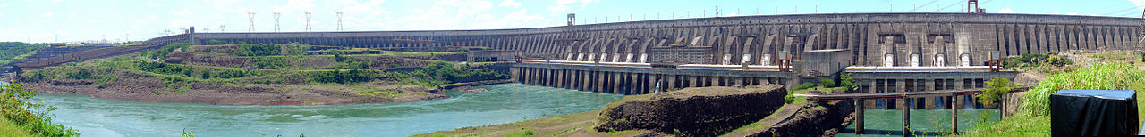