Расположенный в одной из крупнейших в мире естественных гаваней , округ ограничен реками Гудзон , Ист и Гарлем и включает в себя несколько небольших прилегающих островов , включая острова Рузвельта , У Тана и Рэндаллс и Уордс . Он также включает в себя небольшой район Марбл-Хилл, который сейчас находится на материковой части США . Остров Манхэттен разделен на три неформально ограниченных компонента, каждый из которых пересекает длинную ось округа: Нижний Манхэттен, Мидтаун и Верхний Манхэттен . Манхэттен является одним из самых густонаселенных мест в мире, с населением 1 694 250 человек по переписи 2020 года , проживающим на территории площадью 22,66 квадратных миль (58,69 км2 ) , [3] [18] или 72 918 жителей на квадратную милю (28 154 жителей/км2 ) , и совпадающим по протяженности с округом Нью-Йорк, его жилая недвижимость имеет самую высокую цену продажи за квадратный фут в Соединенных Штатах. [19]
Манхэттен исторически был частью территории ленапехокинг, населенной племенами манси , ленапе [ 26] и ваппингер . [27] В этом районе было несколько поселений ленапе, включая Сапоханикан , Нехтанк и Конаанде Конг , которые были связаны между собой серией троп. Основная тропа на острове, которая позже стала Бродвеем , проходила от того, что сейчас называется Инвуд на севере, до Бэттери-парка на юге. [28] По всему Манхэттену были созданы различные места для рыбалки и посадки растений ленапе. [11] Название Манхэттен произошло от языка ленапе, манси , manaháhtaan ( где manah- означает «собирать», -aht- означает « лук », а -aan — абстрактный элемент, используемый для образования основ глаголов ). Слово ленапе переводится как «место, где мы получаем луки» или «место для сбора (дерева для изготовления) луков». Согласно традиции манси, записанной Альбертом Секаккиндом Энтони в 19 веке, остров был назван так из-за рощи деревьев гикори на его южном конце, которая считалась идеальной для изготовления луков. [29]
Колониальная эпоха
В апреле 1524 года флорентийский исследователь Джованни да Верраццано , плававший на службе у Франциска I Французского , стал первым документально подтвержденным европейцем, посетившим территорию, которая впоследствии стала Нью-Йорком. [30] Верраццано вошел в приливный пролив, ныне известный как Нэрроус , и назвал землю вокруг Верхней гавани Нью-Йорка Новым Ангулемом , в честь фамилии короля Франциска I; он заплыл достаточно далеко в гавань, чтобы увидеть реку Гудзон , и назвал залив Санта-Маргарита — то, что сейчас является Верхним заливом Нью-Йорка — в честь Маргариты Наваррской , старшей сестры короля. [31] [32]
Манхэттен был впервые нанесен на карту во время путешествия Генри Гудзона в 1609 году . [33] Гудзон наткнулся на остров Манхэттен и местных жителей, живущих там, и продолжил путь вверх по реке, которая позже будет носить его имя, река Гудзон . [34] Манхэттен был впервые письменно зафиксирован как Манна-хата в бортовом журнале Роберта Джуэта, офицера во время путешествия. [35]
Постоянное европейское присутствие в Новых Нидерландах началось в 1624 году с основанием голландского поселения для торговли пушниной на острове Говернорс . [36] В 1625 году началось строительство цитадели Форта Амстердам на острове Манхэттен, позже названной Новым Амстердамом ( Nieuw Amsterdam ), в том месте, где сейчас находится Нижний Манхэттен. [37] [38] Создание Форта Амстердам считается рождением Нью-Йорка. [39]
В 1647 году Питер Стайвесант был назначен последним голландским генеральным директором колонии. [40] Новый Амстердам был официально включен в качестве города 2 февраля 1653 года . [41] В 1664 году английские войска завоевали Новые Нидерланды и переименовали его в «Нью-Йорк» в честь английского герцога Йоркского и Олбани , будущего короля Якова II. [42] В августе 1673 года голландцы отвоевали колонию, переименовав ее в «Новый Оранж», но в следующем году окончательно передали ее Англии по условиям Вестминстерского договора , положившего конец Третьей англо-голландской войне . [43] [44]
Манхэттен был в центре Нью-Йоркской кампании , серии крупных сражений на ранних этапах Американской войны за независимость . Континентальная армия была вынуждена покинуть Манхэттен после битвы при форте Вашингтон 16 ноября 1776 года. [46] Город, сильно пострадавший от Великого пожара Нью-Йорка во время кампании, стал британским военным и политическим центром операций в Северной Америке на оставшуюся часть войны. [47] Британская оккупация продолжалась до 25 ноября 1783 года, когда Джордж Вашингтон вернулся в Манхэттен, день, отмечаемый как День эвакуации , ознаменовывающий, когда последние британские войска покинули город. [48]
Нью-Йорк вырос как экономический центр, в первую очередь в результате политики и практики Александра Гамильтона , как первого министра финансов, по расширению роли города как центра торговли и промышленности. [54] К 1810 году Нью-Йорк, тогда ограниченный Манхэттеном, превзошел Филадельфию как самый густонаселенный город в Соединенных Штатах. [55] План комиссаров 1811 года разместил остров Манхэттен в его привычном сеточном плане . [56] Роль города как экономического центра выросла с открытием канала Эри в 1825 году, сократив транспортные расходы на 90% по сравнению с автомобильным транспортом и соединив атлантический порт с обширными сельскохозяйственными рынками Среднего Запада Соединенных Штатов и Канады . [57] [58] [59]
«Санитарно-топографическая карта города и острова Нью-Йорк», широко известная как карта Виле, разработанная Эгбертом Людовикусом Виле в 1865 году.
Нью-Йорк сыграл сложную роль в Гражданской войне в США . Город имел прочные коммерческие связи с Югом , но гнев по поводу призыва на военную службу , негодование по поводу военной политики Линкольна и паранойя по поводу того, что свободные чернокожие отнимают рабочие места у бедных иммигрантов [65] достигли кульминации в трехдневных бунтах из-за призыва в Нью-Йорке в июле 1863 года, одном из худших случаев гражданских беспорядков в истории Америки. [66] Уровень иммиграции из Европы резко возрос после Гражданской войны, и Манхэттен стал первой остановкой для миллионов людей, ищущих новую жизнь в Соединенных Штатах, роль которой была признана открытием Статуи Свободы в 1886 году. [67] [68] Эта иммиграция привела к дальнейшим социальным потрясениям. В городе многоквартирных домов, заполненных плохо оплачиваемыми рабочими из десятков стран, город стал рассадником революции (включая анархистов и коммунистов среди прочих), синдикализма , рэкета и профсоюзов . [ необходима ссылка ]
В 1883 году открытие Бруклинского моста через Ист-Ривер установило дорожное сообщение с Бруклином и остальной частью Лонг-Айленда . [69] В 1898 году Нью-Йорк объединился с тремя соседними округами, образовав « Город Большой Нью-Йорк », а Манхэттен был объявлен одним из пяти районов Нью-Йорка . [70] [71] Бронкс оставался частью округа Нью-Йорк до 1914 года, когда был создан округ Бронкс. [72]
Несмотря на Великую депрессию , некоторые из самых высоких небоскребов в мире были построены на Манхэттене в 1930-х годах, включая многочисленные шедевры ар-деко , которые до сих пор являются частью городского горизонта, среди которых наиболее заметны Эмпайр-стейт-билдинг, Крайслер-билдинг и Рокфеллер-плаза , 30. [81] Послевоенный экономический бум привел к развитию огромных жилых комплексов, ориентированных на вернувшихся ветеранов, крупнейшим из которых стал Стайвесант-Таун–Питер Купер-Виллидж , открывшийся в 1947 году. [82] [83] Организация Объединенных Наций переехала в новую штаб-квартиру , строительство которой было завершено в 1952 году вдоль Ист-Ривер. [84] [85] [86]
В 1970-х годах потеря рабочих мест из-за промышленной реструктуризации привела к тому, что Нью-Йорк, включая Манхэттен, страдал от экономических проблем и роста уровня преступности. [91] Хотя возрождение финансовой индустрии значительно улучшило экономическое здоровье города в 1980-х годах, уровень преступности в Нью-Йорке продолжал расти в течение десятилетия и в начале 1990-х годов. [92] В 1980-х годах произошло возрождение Уолл-стрит , и Манхэттен вернул себе роль мирового финансового центра , при этом занятость на Уолл-стрит удвоилась с 1977 по 1987 год. [93] В 1980-х годах Манхэттен также оказался в центре кризиса СПИДа , а Гринвич-Виллидж стал его эпицентром. [94]
В 1970-х годах Таймс-сквер и 42-я улица — с их секс-шопами , пип-шоу и взрослыми театрами, а также с его секс-торговлей , уличной преступностью и общественным употреблением наркотиков — стали символами упадка города, а в 1981 году в журнале Rolling Stone была опубликована статья , в которой участок Западной 42-й улицы между 7-й и 8-й авеню был назван «самым грязным кварталом в Америке». [95] К концу 1990-х годов, благодаря усилиям города и компании Walt Disney Company , этот район возродился как центр туризма до такой степени, что The New York Times описала его как «возможно, самые востребованные 13 акров коммерческой недвижимости в мире». [96]
К 1990-м годам уровень преступности начал резко снижаться [97] [98] , и город снова стал местом назначения иммигрантов со всего мира, что в сочетании с низкими процентными ставками и бонусными выплатами Уолл-стрит способствовало росту рынка недвижимости. [99] В районе Флэтайрон появились новые важные секторы, такие как Кремниевая аллея , закрепив технологии в качестве ключевого компонента экономики Манхэттена. [100]
Взрыв во Всемирном торговом центре в 1993 году , описанный ФБР как «что-то вроде смертоносной генеральной репетиции 11 сентября», был террористическим актом, в результате которого погибли шесть человек, когда на парковке под Северной башней комплекса Всемирного торгового центра был взорван фургон, начиненный взрывчаткой . [101]
29 и 30 октября 2012 года ураган «Сэнди» вызвал обширные разрушения в районе, опустошив части Нижнего Манхэттена рекордно высоким штормовым нагоном из гавани Нью-Йорка, [107] сильным наводнением и сильным ветром, что привело к отключению электроэнергии для сотен тысяч жителей города [108] и привело к нехватке бензина [109] и нарушению работы систем общественного транспорта . [110] [111] [112] [113] Шторм и его серьезные последствия побудили к обсуждению строительства морских дамб и других прибрежных барьеров вокруг береговых линий района и столичной области, чтобы минимизировать риск разрушительных последствий от другого подобного события в будущем. [114]
31 октября 2017 года террорист въехал на грузовике на велосипедную дорожку вдоль шоссе Вест-Сайд в Нижнем Манхэттене, в результате чего погибло восемь человек. [115]
По данным Бюро переписи населения США , округ Нью-Йорк имеет общую площадь 33,6 квадратных миль (87 км 2 ), из которых 22,8 квадратных миль (59 км 2 ) приходится на сушу и 10,8 квадратных миль (28 км 2 ) (32%) — на воду. [1] Северная часть Верхнего Манхэттена представляет собой географический выступ . Остров Манхэттен имеет площадь 22,7 квадратных миль (59 км 2 ), длину 13,4 мили (21,6 км) и ширину 2,3 мили (3,7 км) в самой широкой точке, около 14-й улицы . [116]
Марбл-Хилл был частью северной оконечности острова Манхэттен, но судоходный канал реки Гарлем , вырытый в 1895 году для лучшего соединения рек Гарлем и Гудзон , отделил его от остальной части Манхэттена. [123] Перед Первой мировой войной часть первоначального канала реки Гарлем, отделяющего Марбл-Хилл от Бронкса, была засыпана, и Марбл-Хилл стал частью материка. [124] После постановления суда в мае 1984 года о том, что Марбл-Хилл одновременно является частью боро Манхэттен (не боро Бронкс) и частью округа Бронкс (не округа Нью-Йорк), [125] вопрос был окончательно урегулирован позже в том же году, когда Законодательное собрание Нью-Йорка подавляющим большинством голосов приняло закон, объявляющий район частью как округа Нью-Йорк, так и боро Манхэттен. [126] [127]
Остров Рузвельта , на котором проживает 14 000 человек, простирается на 2 мили (3,2 км) и был переименован в 1973 году из Острова Благосостояния в честь президента Франклина Д. Рузвельта . [131]
Коренная порода, лежащая в основе большей части Манхэттена, состоит из трех скальных образований: мрамора Инвуда , гнейса Фордхэма и сланца Манхэттена , и хорошо подходит для фундамента небоскребов Манхэттена . [132] Он является частью физико-географического региона Манхэттенского зубца .
Зимы холодные и влажные, а преобладающие ветры, дующие с берега, смягчают смягчающее воздействие Атлантического океана , однако Атлантика и частичная защита от более холодного воздуха Аппалачами сохраняют город теплее зимой, чем внутренние североамериканские города на схожих или меньших широтах. Среднесуточная температура в январе, самом холодном месяце в этом районе, составляет 32,6 °F (0,3 °C); [135] температура обычно опускается до 10 °F (−12 °C) несколько раз за зиму, [135] [136] и достигает 60 °F (16 °C) несколько дней в самый холодный зимний месяц. [135] Весна и осень непредсказуемы и могут варьироваться от прохладных до теплых, хотя они обычно мягкие с низкой влажностью. Лето обычно теплое или жаркое и влажное, со средней дневной температурой 76,5 °F (24,7 °C) в июле. [135] Ночные условия часто усугубляются явлением городского острова тепла , из-за которого тепло, поглощенное днем, излучается обратно ночью, повышая температуру на целых 7 °F (4 °C) при слабом ветре. [137] Дневные температуры превышают 90 °F (32 °C) в среднем 17 дней каждое лето [138] и в некоторые годы превышают 100 °F (38 °C). Экстремальные температуры варьировались от −15 °F (−26 °C), зафиксированных 9 февраля 1934 года, до 106 °F (41 °C) 9 июля 1936 года. [138] Манхэттен находится в зоне морозостойкости растений USDA 7b (от 5 до 10 °F/от -15 до -12,2 °C). [139]
Манхэттен получает 49,9 дюймов (1270 мм) осадков в год, которые относительно равномерно распределены в течение года. Среднее количество зимних снегопадов между 1981 и 2010 годами составило 25,8 дюймов (66 см); этот показатель значительно варьируется из года в год. [138]
Многие районы Манхэттена не названы в соответствии с какой-либо конкретной конвенцией, и у них нет официальных границ. Некоторые из них являются географическими ( Верхний Ист-Сайд ) или этнически описательными ( Маленькая Италия ). Другие являются аббревиатурами , такими как TriBeCa (для «ТРЕУГОЛЬНИК ПОД КАНАЛ-СТРИТ») или SoHo («К югу от Хьюстона»), NoLIta («К северу от Маленькой Италии») и NoMad («К северу от парка Мэдисон-сквер»). [142] [143] [144] [145] [146] Гарлем — это название из голландской колониальной эпохи в честь Харлема , города в Нидерландах. [147] Некоторые имеют простые фольклорные названия, такие как Адская кухня , наряду с их более официальным, но реже используемым названием (в данном случае Клинтон). [148]
Манхэттен имеет два центральных деловых района: Финансовый район на южной оконечности острова и Мидтаун Манхэттен . Термин «аптаун» также относится к северной части Манхэттена выше 72-й улицы и к центру города до южной части ниже 14-й улицы [161] , при этом Мидтаун охватывает территорию между ними, хотя определения могут быть изменчивыми. Пятая авеню примерно делит остров Манхэттен пополам и выступает в качестве демаркационной линии для обозначений восток/запад. [161] [162] К югу от Уэверли-Плейс Пятая авеню заканчивается, а Бродвей становится демаркационной линией восток/запад. [ требуется ссылка ] В Манхэттене «аптаун» означает север, а «даунтаун» означает юг. [163] Это использование отличается от использования в большинстве американских городов, где «даунтаун» относится к центральному деловому району.
По данным переписи 2020 года , население Манхэттена за десятилетие увеличилось на 6,8% и составило 1 694 250 человек, что составляет 19,2% от населения Нью-Йорка, составляющего 8 804 194 человека, и 8,4% от населения штата Нью-Йорк, составляющего 20 201 230 человек. [3] Плотность населения округа Нью-Йорк в 2022 году составляла 70 450,8 человек на квадратную милю (27 201,2/км 2 ), что является самой высокой плотностью населения среди округов США и превышает плотность населения любого отдельного города США . [164] [165] По данным переписи 2010 года , в Манхэттене проживало 1 585 873 человека, что на 3,2% больше, чем 1 537 195 человек, подсчитанных в переписи 2000 года . [166]
Религия
In 2010, the largest organized religious group in Manhattan was the Archdiocese of New York, with 323,325 Catholics worshiping at 109 parishes, followed by 64,000 Orthodox Jews with 77 congregations, an estimated 42,545 Muslims with 21 congregations, 42,502 non-denominational adherents with 54 congregations, 26,178 TEC Episcopalians with 46 congregations, 25,048 ABC-USA Baptists with 41 congregations, 24,536 Reform Jews with 10 congregations, 23,982 Mahayana Buddhists with 35 congregations, 10,503 PC-USA Presbyterians with 30 congregations, and 10,268 RCA Presbyterians with 10 congregations. Altogether, 44.0% of the population was claimed as members by religious congregations, although members of historically African-American denominations were underrepresented due to incomplete information.[171] In 2014, Manhattan had 703 religious organizations, the seventeenth most out of all US counties.[172] There is a large Buddhist temple in Manhattan located at the foot of the Manhattan Bridge in Chinatown.[173]
Languages
As of 2015, 60.0% (927,650) of Manhattan residents, aged five and older, spoke only English at home, while 22.63% (350,112) spoke Spanish, 5.37% (83,013) Chinese, 2.21% (34,246) French, 0.85% (13,138) Korean, 0.72% (11,135) Russian, and 0.70% (10,766) Japanese. In total, 40.0% of Manhattan's population, aged five and older, spoke a language other than English at home.[174]
The skyscraper, which has shaped Manhattan's distinctive skyline, has been closely associated with New York City's identity since the end of the 19th century.[178] Structures such as the Equitable Building of 1915, which rises vertically forty stories from the sidewalk, prompted the passage of the 1916 Zoning Resolution, requiring new buildings to contain setbacks withdrawing progressively at a defined angle from the street as they rose, in order to preserve a view of the sky at street level.[179] Manhattan's skyline includes several buildings that are symbolic of New York, in particular the Chrysler Building[180]: 14 and the Empire State Building, which sees about 4 million visitors a year.[181]
In 1961, the struggling Pennsylvania Railroad unveiled plans to tear down the old Penn Station and replace it with a new Madison Square Garden and office building complex.[182] Organized protests were aimed at preserving the McKim, Mead & White-designed structure completed in 1910, widely considered a masterpiece of the Beaux-Arts style and one of the architectural jewels of New York City.[183] Despite these efforts, demolition of the structure began in October 1963.[184] The loss of Penn Station led directly to the enactment in 1965 of a local law establishing the New York City Landmarks Preservation Commission, which is responsible for preserving the "city's historic, aesthetic, and cultural heritage".[185] The historic preservation movement triggered by Penn Station's demise has been credited with the retention of some one million structures nationwide, including over 1,000 in New York City.[186] In 2017, a multibillion-dollar rebuilding plan was unveiled to restore the historic grandeur of Penn Station, in the process of upgrading the landmark's status as a critical transportation hub.[187]
The 700,000 sq ft (65,000 m2) Moynihan Train Hall, developed as a $1.6 billion renovation and expansion of Penn Station into the James A. Farley Building, the city's former main post office building, was opened in January 2021.[188]
Parkland covers a total of 2,659 acres (10.76 km2), accounting for 18.2% of the borough's land area; the 840-acre (3.4 km2) Central Park is the borough's largest park, comprising 31.6% of Manhattan's parkland.[189] Designed by Frederick Law Olmsted and Calvert Vaux, the park is anchored by the 12-acre (4.9 ha) Great Lawn[190] and offers extensive walking tracks, two ice-skating rinks, a wildlife sanctuary, and several lawns and sporting areas, as well as 21 playgrounds,[191] and a 6-mile (9.7 km) road from which automobile traffic has been banned since 2018.[192] While much of the park looks natural, it is almost entirely landscaped; the construction of Central Park in the 1850s was one of the era's most massive public works projects, with some 20,000 workers moving 5 million cubic yards (3.8 million cubic meters) of material to shape the topography and create the English-style pastoral landscape that Olmsted and Vaux sought.[193]
The remaining 70% of Manhattan's parkland includes 204 playgrounds, 251 Greenstreets, 371 basketball courts, and many other amenities.[194] The next-largest park in Manhattan, the Hudson River Park, stretches 4.5 miles (7.2 km) along the Hudson River and comprises 550 acres (220 ha).[195] Other major parks include:[189]
Manhattan is the economic engine of New York City, with its 2.45 million workers drawn from the entire New York metropolitan area accounting for almost more than half of all jobs in New York City.[196] Manhattan's workforce is overwhelmingly focused on white collar professions. In 2010, Manhattan's daytime population was swelling to 3.94 million, with commuters adding a net 1.48 million people to the population, along with visitors, tourists, and commuting students. The commuter influx of 1.61 million workers coming into Manhattan was the largest of any county or city in the country.[197]
Manhattan had the highest per capita income, at $186,848 in 2022, among United States counties with more than 50,000 residents.[198] Based on census data for New York County for 2018–2022, the median household income was $99,880 and the poverty rate was 17.2%.[3] In the second quarter of 2023, Manhattan had an average weekly wage of $2,590, ranked fourth-highest among the nation's 360 largest counties.[196] Data for 2022 from the Census Bureau showed growing inequality, with those in the top 20% having an average household income of $545,549, more than 50 times higher than the $10,529 average income in the lowest 20% of households, the largest gap of any county in the country and "larger ... than in many developing countries",[199][200] with inequality growing steadily since 2010.[201] As of 2023[update], Manhattan's cost of living was the highest in the United States.[202]
New York City is home to the most corporate headquarters of any city in the United States, the overwhelming majority based in Manhattan.[203] Manhattan had more than 520 million square feet (48 million square meters) of office space in 2022,[204] making it the largest office market in the United States; while Midtown Manhattan, with more than 400 million square feet (37 million square meters) is the largest central business district in the world.[205]Lower Manhattan is the third-largest U.S. central business district (following the Chicago Loop).[206][207] New York City's role as the top global center for the advertising industry is metonymously known as "Madison Avenue".[208]
The biotechnology sector is also growing in Manhattan based upon the city's strength in academic scientific research and public and commercial financial support. By mid-2014, Accelerator, a biotech investment firm, had raised more than US$30 million from investors, including Eli Lilly and Company, Pfizer, and Johnson & Johnson, for initial funding to create biotechnology startups at the Alexandria Center for Life Science, which encompasses more than 700,000 square feet (65,000 m2) on East 29th Street and promotes collaboration among scientists and entrepreneurs at the center and with nearby academic, medical, and research institutions. The New York City Economic Development Corporation's Early Stage Life Sciences Funding Initiative and venture capital partners, including Celgene, General Electric Ventures, and Eli Lilly, committed a minimum of US$100 million to help launch 15 to 20 ventures in life sciences and biotechnology.[221] In 2011, Mayor Michael R. Bloomberg had announced his choice of Cornell University and Technion-Israel Institute of Technology to build a US$2 billion graduate school of applied sciences on Roosevelt Island, Manhattan, with the goal of transforming New York City into the world's premier technology capital.[222][223][needs update]
Tourism
Times Square is the hub of Broadway's theater district and a major Manhattan cultural venue with 50 million tourists annually, making it one of the world's most popular tourist destinations.[21]
Tourism is vital to Manhattan's economy, and the landmarks of Manhattan are the focus of New York City's tourists, with a record 66.6 million visiting the city in 2019, bringing in $47.4 billion in tourism revenue. Visitor numbers dropped by two-thirds in 2020 during the COVID-19 pandemic, climbing back to 63.3 million visitors in 2023.[224][225]
According to The Broadway League, shows on Broadway sold approximately US$1.54 billion worth of tickets in the 2022–2023 and the 2023–2024 seasons with attendance of approximately 12.3 million each.[226]
Real estate
Real estate is a major force driving Manhattan's economy. Manhattan has perennially been home to some of the world's most valuable real estate, including the Time Warner Center, which had the highest-listed market value in the city in 2006 at US$1.1 billion,[227] to be subsequently surpassed in October 2014 by the Waldorf Astoria New York, which became the most expensive hotel ever sold after being purchased by the Anbang Insurance Group, based in China, for US$1.95 billion.[228] When 450 Park Avenue was sold on July 2, 2007, for US$510 million, about US$1,589 per square foot (US$17,104/m²), it broke the barely month-old record for an American office building of US$1,476 per square foot (US$15,887/m²) based on the sale of 660 Madison Avenue.[229] In 2014, Manhattan was home to six of the top ten zip codes in the United States by median housing price.[230] In 2019, the most expensive home sale ever in the United States occurred in Manhattan, at a selling price of US$238 million, for a 24,000-square-foot (2,200 m2) penthouse apartment overlooking Central Park,[231] while Central Park Tower, topped out at 1,550 feet (472 m) in 2019, is the world's tallest residential building, followed globally in height by 111 West 57th Street and 432 Park Avenue, both also located in Midtown Manhattan.
Media
Manhattan has been described as the media capital of the world.[232][233] A significant array of media outlets and their journalists report about international, American, business, entertainment, and New York metropolitan area–related matters from Manhattan.
The television industry developed in Manhattan and is a significant employer in the borough's economy. The four major American broadcast networks, ABC, CBS, NBC, and Fox,[238] as well as Univision, are all headquartered in Manhattan, as are many cable channels, including CNN, MSNBC, MTV, Fox News, HBO, and Comedy Central. In 1971, WLIB became New York City's first Black-owned radio station[239] and began broadcasts geared toward the African-American community in 1949.[240] WQHT, also known as Hot 97, claims to be the premier hip-hop station in the United States.[241] WNYC, broadcasting on both an AM and FM signal, has the largest public radio audience in the nation and is the most-listened to commercial or non-commercial radio station in Manhattan.[242] WBAI, owned by the non-profit Pacifica Foundation, broadcasts eclectic music, as well as political news, talk and opinion from a left-leaning viewpoint.[243]
The oldest public-access television cable TV channel in the United States is the Manhattan Neighborhood Network, founded in 1971, offers eclectic local programming that ranges from a jazz hour to discussions of labor issues to foreign language and religious programming.[244] NY1, Charter Communications's local news channel, is known for its beat coverage of City Hall and state politics.[245]
Based on data from the 2011–2015 American Community Survey, 59.9% of Manhattan residents over age 25 have a bachelor's degree.[249] As of 2005, about 60% of residents were college graduates and some 25% had earned advanced degrees, giving Manhattan one of the nation's densest concentrations of highly educated people.[250]
Manhattan is the borough most closely associated with New York City by non-residents; residents within the New York City metropolitan area, including New York City's boroughs outside Manhattan, will often describe a trip to Manhattan as "going to the City".[261] Poet Walt Whitman characterized the streets of Manhattan as being traversed by "hurrying, feverish, electric crowds".[262]
Manhattan has been the scene of many important global and American cultural movements. The Harlem Renaissance in the 1920s established the African-American literary canon in the United States and introduced writers Langston Hughes and Zora Neale Hurston. Manhattan's visual art scene in the 1950s and 1960s was a center of the pop art movement, which gave birth to such giants as Jasper Johns and Roy Lichtenstein. The downtown pop art movement of the late 1970s included artist Andy Warhol and clubs like Serendipity 3 and Studio 54, where he socialized.
Manhattan is the epicenter of LGBT culture and the central node of the LGBTQ+ sociopolitical ecosystem.[273] The borough is widely acclaimed as the cradle of the modern LGBTQ rights movement, with its inception at the 1969 Stonewall Riots.[88][274][275][89][276] Brian Silverman, the author of Frommer's New York City from $90 a Day, wrote the city has "one of the world's largest, loudest, and most powerful LGBT communities", and "Gay and lesbian culture is as much a part of New York's basic identity as yellow cabs, high-rise buildings, and Broadway theatre"—[277] radiating from this central hub, as LGBT travel guideQueer in the World states, "The fabulosity of Gay New York is unrivaled on Earth, and queer culture seeps into every corner of its five boroughs".[278] Multiple gay villages have developed, spanning the length of the borough from the Lower East Side, East Village, and Greenwich Village, through Chelsea and Hell's Kitchen, uptown to Morningside Heights.
The annual NYC Pride March (or gay pride parade) traverses southward down Fifth Avenue and ends at Greenwich Village; the Manhattan parade is the largest pride parade in the world, attracting tens of thousands of participants and millions of sidewalk spectators each June.[271][272]Stonewall 50 – WorldPride NYC 2019 was the largest international Pride celebration in history, produced by Heritage of Pride. The events were in partnership with the I ❤ NY program's LGBT division, commemorating the 50th anniversary of the Stonewall uprising, with 150,000 participants and five million spectators attending in Manhattan.[279]
The borough is represented in several prominent idioms. The phrase New York minute is meant to convey an extremely short time such as an instant,[280] sometimes in hyperbolic form, as in "perhaps faster than you would believe is possible," referring to the rapid pace of life in Manhattan.[281][282] The expression "melting pot" was first popularly coined to describe the densely populated immigrant neighborhoods on the Lower East Side in Israel Zangwill's play The Melting Pot, which was an adaptation of William Shakespeare's Romeo and Juliet set in New York City in 1908.[283] The iconic Flatiron Building is said to have been the source of the phrase "23 skidoo" or scram, from what cops would shout at men who tried to get glimpses of women's dresses being blown up by the winds created by the triangular building.[284] The "Big Apple" dates back to the 1920s, when a reporter heard the term used by New Orleans stable-hands to refer to New York City's horse racetracks and named his racing column "Around The Big Apple". Jazz musicians adopted the term to refer to the city as the world's jazz capital, and a 1970s ad campaign by the New York Convention and Visitors Bureau helped popularize the term.[285]
Manhattan is well known for its street parades, which celebrate a broad array of themes, including holidays, nationalities, human rights, and major league sports team championship victories. The majority of higher profile parades in New York City are held in Manhattan. The primary orientation of the annual street parades is typically from north to south, marching along major avenues. The annual Macy's Thanksgiving Day Parade is the world's largest parade,[286] beginning alongside Central Park and processing southward to the flagship Macy's Herald Square store;[289] the parade is viewed on telecasts worldwide and draws millions of spectators in person.[286]
Other notable parades including the world's oldest St. Patrick's Day Parade, held annually in March since 1762,[290][291] the Greenwich Village Halloween Parade in October,[292] and numerous parades commemorating the independence days of many nations.[293]Ticker-tape parades celebrating sporting championships won as well as other national accomplishments march northward on Broadway from Bowling Green to City Hall Park in Lower Manhattan, along the Canyon of Heroes.[294]New York Fashion Week, held at various locations in Manhattan, is a high-profile semiannual event featuring models displaying the latest wardrobes created by prominent fashion designers worldwide in advance of these fashions proceeding to the retail marketplace.
Manhattan does not currently host a professional baseball franchise. The original New York Giants played primarily in the various incarnations of the Polo Grounds from their inception in 1883 until they headed to California with the Brooklyn Dodgers after the 1957 season.[297] The New York Yankees began their franchise as the Highlanders, named for Hilltop Park, where they played from their creation in 1903 until 1912.[298] The team moved to the Polo Grounds with the 1913 season, where they were officially christened the New York Yankees, remaining there until they moved across the Harlem River in 1923 to Yankee Stadium.[299] The New York Mets played in the Polo Grounds in 1962 and 1963, their first two seasons, before Shea Stadium was completed in 1964.[300] After the Mets departed, the Polo Grounds was demolished in April 1964.[301][302]
The first national college-level basketball championship, the National Invitation Tournament, was held in New York in 1938 and remains in the city.[303] The New York Knicks started play in 1946 as one of the National Basketball Association's original teams, playing their first home games at the 69th Regiment Armory, before making Madison Square Garden their permanent home.[304] The New York Liberty of the WNBA shared the Garden with the Knicks from their creation in 1997 as one of the league's original eight teams through the 2017 season,[305] after which the team moved nearly all of its home schedule to White Plains, New York.[306]Rucker Park in Harlem is a playground court, famed for its streetball style of play, where many NBA athletes have played in the summer league.[307]
Although both of New York City's football teams play today in MetLife Stadium in East Rutherford, New Jersey, both teams started out playing in the Polo Grounds. The New York Giants played side-by-side with their baseball namesakes from the time they entered the National Football League in 1925, until crossing over to Yankee Stadium in 1956.[308] The New York Jets, originally known as the Titans of New York, started out in 1960 at the Polo Grounds, before joining the Mets in Queens at Shea Stadium in 1964.[309]
The New York Rangers of the National Hockey League have played in the various locations of Madison Square Garden since the team's founding in the 1926–1927 season. The Rangers were predated by the New York Americans, who started play in the Garden the previous season, lasting until the team folded after the 1941–1942 NHL season, a season it played in the Garden as the Brooklyn Americans.[310]
The New York Cosmos of the North American Soccer League played their home games at Downing Stadium for two seasons, starting in 1974. The playing pitch and facilities at Downing Stadium were in unsatisfactory condition, however, and as the team's popularity grew they too left for Yankee Stadium, and then Giants Stadium. The stadium was demolished in 2002 to make way for the $45 million, 4,754-seat Icahn Stadium.[311][312]
Since New York City's consolidation in 1898, Manhattan has been governed by the New York City Charter; its 1989 revision provided for a strong mayor–council system.[313] The centralized New York City government is responsible for public education, correctional institutions, libraries, public safety, recreational facilities, sanitation, water supply, and welfare services in Manhattan.
The office of Borough President was created in the consolidation of 1898 to balance centralization with local authority. Each borough president had a powerful administrative role derived from having a vote on the New York City Board of Estimate, which was responsible for creating and approving the city's budget and proposals for land use. In 1989, the US Supreme Court declared the Board of Estimate unconstitutional because Brooklyn, the most populous borough, had no greater effective representation on the Board than Staten Island, the least populous borough, a violation of the Equal Protection Clause.[314] Since 1990, the largely powerless Borough President has acted as an advocate for the borough at the mayoral agencies, the City Council, the New York state government, and corporations.[citation needed] Manhattan's current Borough President is Mark Levine, elected as a Democrat in November 2021.
Alvin Bragg, a Democrat, is the District Attorney of New York County. Manhattan has ten City Council members, the third largest contingent among the five boroughs. It also has twelve administrative districts, each served by a local Community Board. Community Boards are representative bodies that field complaints and serve as advocates for local residents.
As the host of the United Nations, the borough is home to the world's largest international consular corps, comprising 105 consulates, consulates general and honorary consulates.[315] It is also the home of New York City Hall, the seat of New York City government housing the Mayor of New York City and the New York City Council. The mayor's staff and thirteen municipal agencies are located in the nearby Manhattan Municipal Building, completed in 1914, one of the largest governmental buildings in the world.[316]
The Democratic Party holds most public offices. Registered Republicans are a minority in the borough, constituting 9.88% of the electorate as of April 2016[update]. Registered Republicans are more than 20% of the electorate only in the neighborhoods of the Upper East Side and the Financial District as of 2016[update]. Democrats accounted for 68.41% of those registered to vote, while 17.94% of voters were unaffiliated.[320][321]
Starting in the mid-19th century, the United States became a magnet for immigrants seeking to escape poverty in their home countries. After arriving in New York, many new arrivals ended up living in squalor in the slums of the Five Points neighborhood, an area between Broadway and the Bowery, northeast of New York City Hall. By the 1820s, the area was home to many gambling dens and brothels, and was known as a dangerous place to go. In 1842, Charles Dickens visited the area and was appalled at the horrendous living conditions he had seen.[324] The predominantly Irish Five Points Gang was one of the country's first major organized crime entities.
As Italian immigration grew in the early 20th century many joined ethnic gangs, including Al Capone, who got his start in crime with the Five Points Gang.[325]The Mafia (also known as Cosa Nostra) first developed in the mid-19th century in Sicily and spread to the US East Coast during the late 19th century following waves of Sicilian and Southern Italian emigration. Lucky Luciano established Cosa Nostra in Manhattan, forming alliances with other criminal enterprises, including the Jewish mob, led by Meyer Lansky, the leading Jewish gangster of that period.[326] From 1920 to 1933, Prohibition helped create a thriving black market in liquor, upon which the Mafia was quick to capitalize.[326]
New York City as a whole experienced a sharp increase in crime during the post-war period.[327] The murder rate in Manhattan hit an all-time high of 42 murders per 100,000 residents in 1979.[328] Manhattan retained the highest murder rate in the city until 1985 when it was surpassed by the Bronx.[328] Most serious violent crime has been historically concentrated in Upper Manhattan and the Lower East Side, though robbery in particular was a major quality of life concern throughout the borough. Through the 1990s and 2000s, levels of violent crime in Manhattan plummeted to levels not seen since the 1950s,[329] with murders in Manhattan dropping from 503 in 1990, at the citywide peak, to 78 in 2022, a decline of 84%.[330]
Today crime rates in most of Lower Manhattan, Midtown, the Upper East Side, and the Upper West Side are consistent with other major city centers in the United States. However, crime rates remain high in the Upper Manhattan neighborhoods of East Harlem, Harlem, Washington Heights, Inwood, and New York City Housing Authority developments across the borough, despite significant reductions. After the start of the COVID-19 pandemic in March 2020, there had been an increase in violent crime, particularly in Upper Manhattan.[331] Mirroring a nationwide trend, rates of shootings and violent crimes in 2023 declined from their peaks during the pandemic.[332][333][334]
Housing
Tenement houses in 1936
The rise of immigration near the turn of the 20th century left major portions of Manhattan, especially the Lower East Side, densely packed with recent arrivals, crammed into unhealthy and unsanitary housing. Tenements were usually five stories high, constructed on the then-typical 25 by 100 feet (7.6 by 30.5 m) lots, with "cockroach landlords" exploiting the new immigrants.[335][336] By 1929, a new housing code effectively ended construction of tenements, though some survive today on the East Side of the borough.[336] Conversely, there were also areas with luxury apartment developments, the first of which was the Dakota on the Upper West Side.[337]
Manhattan offers a wide array of private housing, as well as public housing, which is administered by the New York City Housing Authority (NYCHA). Affordable rental and co-operative housing units throughout the borough were created under the Mitchell–Lama Housing Program.[338] There were 923,302 housing units in 2022[3] at an average density of 40,745 units per square mile (15,732/km2). As of 2003[update], only 24.3% of Manhattan residents lived in owner-occupied housing, the second-lowest rate of all counties in the nation, after the Bronx.[339] Public housing administered by NYCHA accounts for nearly 100,000 residents in more than 50,000 units in 2023.[340] Completed in 1935, the First Houses in the East Village were one of the country's first publicly-funded low-income housing projects.[341][342] At $2,024 in 2022, Manhattan has the highest average cost for rent of any county in the US, although a lower percentage of annual income than in several other American cities.[343]
Manhattan's real estate market for luxury housing continues to be among the most expensive in the world,[344] and Manhattan residential property continues to have the highest sale price per square foot in the United States.[19] Manhattan's apartments cost $1,773 per square foot ($19,080/m2), compared to San Francisco housing at $1,185 per square foot ($12,760/m2), Boston housing at $751 per square foot ($8,080/m2), and Los Angeles housing at $451 per square foot ($4,850/m2).[345] As of the fourth quarter of 2021, the median value of homes in Manhattan was $1,306,208, second highest among US counties.[346]
Manhattan is unique in the U.S. for intense use of public transportation and lack of private car ownership. While 88% of Americans nationwide drive to their jobs, with only 5% using public transport, mass transit is the dominant form of travel for residents of Manhattan, with 72% of borough residents using public transport to get to work, while only 18% drove.[347][348] According to the 2000 United States Census, 77.5% of Manhattan households do not own a car.[349] In 2008, Mayor Michael Bloomberg proposed a congestion pricing system to regulate entering Manhattan south of 60th Street, but the state legislature rejected the proposal.[350]
The New York City Subway, the largest subway system in the world by number of stations, is the primary means of travel within the city, linking every borough except Staten Island. There are 151 subway stations in Manhattan, out of the 472 stations.[351] A second subway, the PATH system, connects six stations in Manhattan to northern New Jersey. Passengers pay fares with pay-per-ride MetroCards, which are valid on all city buses and subways, as well as on PATH trains.[352][353]Commuter rail services operating to and from Manhattan are the Long Island Rail Road (LIRR), which connects Manhattan and other New York City boroughs to Long Island; the Metro-North Railroad, which connects Manhattan to Upstate New York and Southwestern Connecticut; and NJ Transit trains, which run to various points in New Jersey.
MTA New York City Transit offers a wide variety of local buses within Manhattan under the brand New York City Bus. An extensive network of express bus routes serves commuters and other travelers heading into Manhattan.[362] The bus system served 784 million passengers citywide in 2011, placing the bus system's ridership as the highest in the nation, and more than double the ridership of the second-place Los Angeles system.[363]
The Roosevelt Island Tramway, one of two commuter cable car systems in North America, takes commuters between Roosevelt Island and Manhattan in less than five minutes, and has been serving the island since 1978.[364][365]
The Staten Island Ferry, which runs 24 hours a day, 365 days a year, annually carries over 21 million passengers on the 5.2-mile (8.4 km) run between Manhattan and Staten Island. Each weekday, five vessels transport about 65,000 passengers on 109 boat trips.[366][367] The ferry has been fare-free since 1997.[368] In February 2015, Mayor Bill de Blasio announced that the city government would begin NYC Ferry to extend ferry transportation to traditionally underserved communities in the city.[369][370] The first routes of NYC Ferry opened in 2017.[371][372] All of the system's routes have termini in Manhattan, and the Lower East Side and Soundview routes also have intermediate stops on the East River.[373]
The metro region's commuter rail lines converge at Penn Station and Grand Central Terminal, on the west and east sides of Midtown Manhattan, respectively. They are the two busiest rail stations in the United States. About one-third of users of mass transit and two-thirds of railway passengers in the country live in New York and its suburbs.[376]Amtrak provides inter-city passenger rail service from Penn Station to Boston, Philadelphia, Baltimore, and Washington, D.C.; Upstate New York and New England; cross-Canadian border service to Toronto and Montreal; and destinations in the Southern and Midwestern United States.
The Port Authority Bus Terminal is the city's main intercity bus terminal and the world's busiest bus station. It serves 250,000 passengers on 7,000 buses each workday in a 1950 building designed to accommodate 60,000 daily passengers. A 2021 plan announced by the Port Authority would spend $10 billion to expand capacity and modernize the facility.[375][377][374] In 2024, the Port Authority announced plans for a new terminal that would be completed by 2032 and include a pair of office buildings to defray the costs of the project.[378]
New York's iconic yellow taxicabs, which number 13,087 citywide and must have a medallion authorizing the pickup of street hails, are ubiquitous in the borough.[379] Private vehicle for hire companies provide significant competition for taxicabs.[380]
The Commissioners' Plan of 1811 called for twelve numbered "avenues" running north and south roughly parallel to the Hudson River, each 100 feet (30 m) wide, with First Avenue on the east side and Twelfth Avenue on the west side.[56][382] There are several intermittent avenues east of First Avenue, including four additional lettered avenues running from Avenue A eastward to Avenue D in an area now known as Alphabet City.[383] The numbered streets in Manhattan run east–west, and are generally 60 feet (18 m) wide, with about 200 feet (61 m) between streets.[56] The address algorithm of Manhattan is used to estimate the closest east–west cross street for building numbers on north–south avenues.[384]
According to the original Commissioner's Plan, there were 155 numbered crosstown streets,[385] but later the grid was extended up to the northernmost corner of Manhattan Island, where the last numbered street is 220th Street, though the grid continues to 228th Street in the borough's Marble Hill neighborhood.[386][387] Fifteen crosstown streets were designated as 100 feet (30 m) wide, including 34th, 42nd, 57th and 125th Streets,[388] which became some of the borough's most significant transportation and shopping venues. Broadway, following the route of a Native American trail, is the most notable of many exceptions to the grid, starting at Bowling Green in Lower Manhattan and continuing north for 13 miles (21 km) into the Bronx.[389] In much of Midtown Manhattan, Broadway runs at a diagonal to the grid, creating major named intersections at Union Square, Madison Square, Herald Square, Times Square, and Columbus Circle.[390][391]
"Crosstown streets" refers primarily to major east-west streets connecting Manhattan's East Side and West Side. The trip is notoriously frustrating for drivers because of heavy congestion on narrow local streets; absence of express roads other than the Trans-Manhattan Expressway at the far north end of Manhattan Island; and restricted to very limited crosstown automobile travel within Central Park. Proposals to build highways traversing the island through Manhattan's densest neighborhoods, namely the Mid-Manhattan Expressway across 34th Street and the Lower Manhattan Expressway through SoHo, failed in the 1960s.[392][393] In New York City, all turns at red lights are illegal unless a sign permitting such maneuvers is present, significantly shaping traffic patterns in Manhattan.[394]
Another consequence of the strict grid plan of most of Manhattan, and the grid's skew of approximately 28.9 degrees, is a phenomenon sometimes referred to as Manhattanhenge (by analogy with Stonehenge).[395] On May 28 and July 12, the sunset is aligned with the street grid lines, with the result that the sun is visible at or near the western horizon from street level.[395][396] A similar phenomenon occurs with the sunrise on the eastern horizon on December 5 and January 8.[397]
Several tunnels also link Manhattan Island to New York City's outer boroughs and New Jersey. The Lincoln Tunnel, which carries 120,000 vehicles a day under the Hudson River between New Jersey and Midtown Manhattan, is the busiest vehicular tunnel in the world.[403] The tunnel was built instead of a bridge to allow unfettered passage of large passenger and cargo ships that sail through New York Harbor and up the Hudson River to Manhattan's piers. The Holland Tunnel, connecting Lower Manhattan to Jersey City, New Jersey, was the world's first mechanically ventilated vehicular tunnel.[404] The Queens–Midtown Tunnel, built to relieve congestion on the bridges connecting Manhattan with Queens and Brooklyn, was the largest non-federal project in its time when it was completed in 1940;[405] President Franklin D. Roosevelt was the first person to drive through it.[406] The Brooklyn–Battery Tunnel runs underneath Battery Park and connects the Financial District at the southern tip of Manhattan to Red Hook in Brooklyn.
Several ferry services operate between New Jersey and Manhattan.[407] These ferries mainly serve midtown, Battery Park City, and Wall Street.
Gas and electric service is provided by Consolidated Edison. Manhattan witnessed the doubling of its natural gas supply when a new gas pipeline opened on November 1, 2013.[409]Con Edison operates the world's largest district steam system, which consists of 105 miles (169 km) of steam pipes, providing steam for heating, hot water, and air conditioning[410] by some 1,800 Manhattan customers.[411] Cable service is provided by Time Warner Cable and telephone service is provided by Verizon Communications, although AT&T is available as well.
The New York City Department of Sanitation is responsible for garbage removal.[412] The bulk of the city's trash is disposed at mega-dumps in Pennsylvania, Virginia, South Carolina, and Ohio (via transfer stations in New Jersey, Brooklyn and Queens) since the 2001 closure of the Fresh Kills Landfill on Staten Island.[413] A small amount of trash processed at transfer sites in New Jersey is sometimes incinerated at waste-to-energy facilities.
New York City has the largest clean-air diesel-hybrid and compressed natural gas bus fleet, which also operates in Manhattan, in the country. It also has some of the first hybrid taxis, most of which operate in Manhattan.[414]
Health care
There are many hospitals in Manhattan, including two of the 25 largest in the United States (as of 2017):[415]
New York City is supplied with drinking water by the protected Catskill Mountains watershed.[416] As a result of the watershed's integrity and undisturbed natural water filtration system, New York is one of only four major cities in the US with a majority of drinking water pure enough not to require purification by water treatment plants.[417] The Croton Watershed north of the city is undergoing construction of a US$3.2 billion water purification plant to augment New York City's water supply by an estimated 290 million gallons daily, representing a greater than 20% addition to the city's current availability of water.[418] Water comes to Manhattan through the tunnels 1 and 2, and in the future through Tunnel No. 3, begun in 1970.[419]
^Mean monthly maxima and minima (i.e. the expected highest and lowest temperature readings at any point during the year or given month) calculated based on data at said location from 1991 to 2020.
^Official weather observations for Central Park were conducted at the Arsenal at Fifth Avenue and 64th Street from 1869 to 1919, and at Belvedere Castle since 1919.[140]
^The presidential election results for the years 1876–1912 are not strictly comparable with the earlier and later ones because New York County included the West Bronx after 1874 and all of what is now the Borough of the Bronx (Bronx County, New York) from 1895 until The Bronx became a separate borough in 1914.
^ a b c d e f gQuickFacts New York; New York city, New York; New York County, New York, United States Census Bureau. Accessed January 5, 2024.
^Moynihan, Colin. "F.Y.I." Archived April 17, 2020, at the Wayback Machine, The New York Times, September 19, 1999. Accessed December 17, 2019. "There are well-known names for inhabitants of four boroughs: Manhattanites, Brooklynites, Bronxites and Staten Islanders. But what are residents of Queens called?"
^"Gross Domestic Product by County and Metropolitan Area, 2022" (PDF). www.bea.gov. Bureau of Economic Analysis.
^"World Urban Areas" (PDF). Demographia. April 2018. Retrieved April 27, 2018.
^"A Nation challenged: in New York; New York Carries On, but Test of Its Grit Has Just Begun" Archived March 24, 2020, at the Wayback Machine, The New York Times, October 11, 2001. Accessed November 20, 2016. "A roaring void has been created in the financial center of the world."
^Sorrentino, Christopher (September 16, 2007). "When He Was Seventeen". The New York Times. Retrieved December 22, 2007. In 1980, there were still the remains of the various downtown revolutions that had reinvigorated New York's music and art scenes and kept Manhattan in the position it had occupied since the 1940s as the cultural center of the world.
^Michael P. Ventura (April 6, 2010). "Manhattan May Be the Media Capital of the World, But Not For iPad Users". DNAinfo. Archived from the original on August 4, 2017. Retrieved June 11, 2017.
^Dawn Ennis (May 24, 2017). "ABC will broadcast New York's pride parade live for the first time". LGBTQ Nation. Archived from the original on July 28, 2017. Retrieved June 4, 2017.
^ a bBurrows, Edwin G.; Wallace, Mike (1998). Gotham : a history of New York City to 1898. Mike Wallace. Oxford: Oxford University Press. pp. 6–7. ISBN 978-0-585-36462-9. OCLC 47011419.
^"KINGSTON Discover 300 Years of New York History DUTCH COLONIES". National Park Service, U.S. Department of the Interior. Archived from the original on November 23, 2008. Retrieved April 7, 2018.
^"The Nine Capitals of the United States". United States Senate. Archived from the original on March 20, 2016. Retrieved April 7, 2018.
^"Statue of Liberty". World Heritage. UNESCO World Heritage Centre 1992–2011. Archived from the original on August 28, 2012. Retrieved April 7, 2018.
^Michael M. Grynbaum (May 24, 2012). "The Reporters of City Hall Return to Their Old Perch". The New York Times. Archived from the original on June 25, 2017. Retrieved December 5, 2013.
^"Workforce Diversity The Stonewall Inn, National Historic Landmark National Register Number: 99000562". National Park Service, U.S. Department of the Interior. Archived from the original on March 6, 2016. Retrieved July 2, 2013.
^"Obama inaugural speech references Stonewall gay-rights riots". North Jersey Media Group Inc. January 21, 2013. Archived from the original on May 30, 2013. Retrieved July 2, 2013.
^"2020 Census Urban Areas Facts (2020)". United States Census Bureau. Retrieved January 12, 2024.
^ a bManhattan, NY Homes for Sale Archived August 15, 2018, at the Wayback Machine, Redfin. Accessed January 31, 2018.
^ a bNeufeld, Dorothy. "Mapped: The Largest Stock Exchanges in the World", Virtual Capitalist, October 18, 2023. Accessed December 26, 2023.
^ a bAnn Shields (November 10, 2014). "The World's 50 Most Visited Tourist Attractions – No. 3: Times Square, New York City – Annual Visitors: 50,000,000". Travel+Lesiure. Archived from the original on July 21, 2015. Retrieved July 12, 2015. No. 3 Times Square, ... No. 4 (tie) Central Park, ... No. 10 Grand Central Terminal, New York City
^Michael Kimmelman (September 30, 2016). "Penn Station Reborn". The New York Times. Retrieved August 3, 2022.
^Sarah Waxman. "The History of New York's Chinatown". Mediabridge Infosystems, Inc. Retrieved January 12, 2024. Manhattan's Chinatown, the largest Chinatown in the United States and the site of the largest concentration of Chinese in the Western Hemisphere, is located on the Lower East Side.
^"New York's Fifth Avenue Retains its Top Ranking as the World's Most Expensive Retail Destination". Cushman & Wakefield. November 20, 2023. Retrieved July 31, 2024.
^"Buildings in New York City". Council on Tall Buildings and Urban Habitat. Archived from the original on July 17, 2011. Retrieved June 8, 2011.
^Magazine, Smithsonian. "The True Native New Yorkers Can Never Truly Reclaim Their Homeland". Smithsonian Magazine. Retrieved June 29, 2022.
^Broadway, Society of Architectural Historians. Accessed November 30, 2023. "Predating the Commissioners' Plan of 1811, Broadway was initially a Native American trading trail running the length of Manhattan. Various indigenous peoples living on the island—including Lenni Lenape, Delaware Lenape, and Wickquasgeck—used the route, known as the Wickquasgeck Trail, to exchange goods with each other. Following Dutch settlement in 1609 and the establishment of Fort Amsterdam in lower Manhattan, the Wickquasgeck Trail's southern endpoint became a site for trading between the indigenous peoples and the European colonists."
^Goddard, Ives (2010). "The Origin and Meaning of the Name "Manhattan"". New York History. 91 (4): 277–293. hdl:10088/16790. ISSN 0146-437X – via Smithsonian Research Online.
^Giovanni da Verrazzano, Mariners' Museum and Park. Accessed December 24, 2023. "Verrazzano sailed onward, continuing his search for the Northwest Passage. In mid-April 1524, Verrazzano and his crew became the first known Europeans to sail into New York Bay. Once again they were greeted peacefully by the Native Americans and treated well."
^R. J. Knecht: Renaissance Warrior and Patron: The Reign of Francis I; p. 372. Cambridge University Press (1996) ISBN 0-521-57885-X
^Rankin, Rebecca B.; Cleveland Rodgers (1948). New York: the World's Capital City, Its Development and Contributions to Progress. Harper.
^"Henry Hudson and His Exploration" Archived January 18, 2012, at the Wayback MachineScientific American, September 25, 1909. Accessed May 1, 2007. "This was a vain hope however, and the conviction must finally have come to the heart of the intrepid adventurer that once again he was foiled in his repeated quest for the northwest passage ... On the following day the Half Moon let go her anchor inside of Sandy Hook. The week was spent in exploring the bay with a shallop, or small boat, and "they found a good entrance between two headlands" (the Narrows) "and thus entered on the 12th of September into as fine a river as can be found""
^Juet, Robert (2006) [1625]. "Juet's Journal of Hudson's 1609 Voyage, from the 1625 Edition of Purchas His Pilgrimes". The New York Times. Translated by Brea Barthel. p. 16. Archived from the original on July 3, 2016. Retrieved May 11, 2020.
^History, Governor's Island. Accessed December 24, 2023. "The Dutch West India Company first arrived to New Amsterdam and opted to set up camp on the small, 70-acre Island rather than brave the wilderness that lay across the water on the island that would later be known as Manhattan."
^Dutch Colonies Archived May 19, 2010, at the Wayback Machine, National Park Service. Accessed May 19, 2007. "Sponsored by the West India Company, 30 families arrived in North America in 1624, establishing a settlement on present-day Manhattan."
^GovIsland Park-to-Tolerance: through Broad Awareness and Conscious Vigilance Archived August 24, 2019, at the Wayback Machine, Tolerance Park. Accessed November 20, 2016. See Legislative Resolutions Senate No. 5476 and Assembly No. 2708.
^City Seal and Flag Archived April 28, 2015, at the Wayback Machine, New York City. Accessed November 20, 2016. "Date: Beneath the horizontal laurel branch the date 1625, being the year of the establishment of New Amsterdam."
^Journal of New Netherland 1647. Written in the Years 1641, 1642, 1643, 1644, 1645, and 1646., Library of Congress. Accessed August 6, 2023. "The West India Company removed Kieft from his post in 1647 and replaced him with Peter Stuyvesant, the last director-general of New Netherland before the colony was taken over by the English in 1664."
^New Netherlands Becomes New York, University of Houston Digital History. Accessed January 3, 2024. "In 1664, the English sent a fleet to seize New Netherlands, which surrendered without a fight. The English renamed the colony New York, after James, the Duke of York, who had received a charter to the territory from his brother King Charles II."
^Scheltema, Gajus and Westerhuijs, Heleen (eds.),Exploring Historic Dutch New York. Museum of the City of New York/Dover Publications, New York (2011). ISBN 978-0-486-48637-6
^"History of New York City - 1600s NYC", History 101 NYC. Accessed January 3, 2024. "1673: A pivotal moment in New York City's history when Dutch forces briefly reclaimed it during the Third Anglo-Dutch War. The city, captured by the English in 1664 and renamed New York, was temporarily dubbed New Orange in honor of William of Orange.... 1674: The Treaty of Westminster, signed in February, officially concluded the Third Anglo-Dutch War. This treaty marked a crucial turn in colonial history, transferring New York permanently to English control."
^"The Inauguration of George Washington, 1789". Eyewitness to History. Ibis Communications, Inc. 2005. Archived from the original on January 10, 2013. Retrieved January 6, 2013.
^Fort Washington, American Battlefield Trust. Accessed November 30, 2023. "Fought on November 16, 1776 on the island of Manhattan, the Battle of Fort Washington was the final devastating chapter in General Washington's disastrous New York Campaign.... At 3:00 P.M., after a fruitless attempt to gain gentler surrender terms for his men, Magaw surrendered Fort Washington and its 2,800 surviving defenders to the British."
^Axelson, Erik Peter."Happy Evacuation Day" Archived October 5, 2008, at the Wayback Machine, New York City Department of Parks and Recreation, November 23, 2005. Accessed December 24, 2023. "During the Revolutionary War, New York City was occupied by British forces (from September 15, 1776 to November 25, 1783). For generations afterward, New Yorkers celebrated its repatriation from the British as Evacuation Day."
^"January Highlight: Superintending Independence, Part 1", Harvard University Declaration Resources Project, January 4, 2017. Accessed December 24, 2023. "From January 11, 1785 through 1789, the Congress of the Confederation met in New York City, at City Hall (which later became Federal Hall) and at Fraunces Tavern."
^The Nine Capitals of the United States Archived March 20, 2016, at the Wayback Machine. United States Senate Historical Office. Accessed June 9, 2005. Based on Fortenbaugh, Robert, The Nine Capitals of the United States, York, Pennsylvania: Maple Press, 1948...
^"Birthplace of American Government". National Park Service. Archived from the original on September 12, 2014. Retrieved September 21, 2014.
^Lynch, Jack. "Debating the Bill of Rights". Colonial Williamsburg Foundation. Archived from the original on July 5, 2014. Retrieved September 21, 2014.
^History & Culture: Federal Hall National Memorial, National Park Service. Accessed November 30, 2023. "After the American Revolution, the Continental Congress met at City Hall and, in 1787, adopted the Northwest Ordinance, establishing procedures for creating new states."
^Historic New York, American Experience. Accessed December 24, 2023. "But New York's enormous Revolutionary War debt had the federal government hovering on the brink of bankruptcy, so Alexander Hamilton struck a momentous deal with Thomas Jefferson.... Alexander Hamilton's extraordinary early vision helped invent the economic future not only for his adoptive city, but also for the rest of the United States. Although the country was 90% agrarian, Hamilton understood that the future lay in manufacturing. As the first Secretary of the Treasury in New York City in 1789, he mapped out a blueprint for a new kind of nation – one based not on plantations and slave labor, but on commerce, manufacturing, and immigrant toil."
^Dunlap, David W. "Last Time New York Had Just 27 House Seats? The City Was on the Rise", Archived September 24, 2014, at the Wayback MachineThe New York Times, December 1, 2010. Accessed December 24, 2023. "Even as war with Britain seemed more and more inevitable, however, New York spent much of 1810 — boisterously and confidently — developing into the American metropolis. New York, just as I pictured it. This was the year New York surpassed Philadelphia in population to become the largest city of the young republic, with 96,373 people; 94,687 of whom were free, 1,686 of whom were enslaved."
^ a b cThe Commissioners' Plan, 1811, Museum of the City of New York. Accessed December 1, 2023. "The avenues are 100 feet wide, the standard cross street is 60 feet, and major cross streets are 100 feet.... The second pattern derives from block dimensions: all blocks are 200 feet north to south, but their dimensions east to west vary, diminishing in width from the center of the island to the shorelines."
^Bridges, William (1811). Map of the City of New York and Island of Manhattan with Explanatory Remarks and References.
^Lankevich (1998), pp. 67–68.
^Canal History, New York State Canal Corporation. Accessed January 3, 2024. "In 1825, Governor Dewitt Clinton officially opened the Erie Canal as he sailed the packet boat Seneca Chief along the Canal from Buffalo to Albany.... The explosion of trade prophesied by Governor Clinton began, spurred by freight rates from Buffalo to New York of $10 per ton by Canal, compared with $100 per ton by road.... The Erie Canal played an integral role in the transformation of New York City into the nation's leading port, a national identity that continues to be reflected in many songs, legends and artwork today."
^"Sachems & Sinners An Informal History Of Tammany Hall", Time, August 22, 1955. Accessed December 1, 2023. "Born in Philadelphia, Wood went to New York to become an actor, but turned instead to politics and rose to become the first real Boss of Tammany Hall. In 1854 he became Mayor of New York City."
^Blair, Cynthia. "1858: Central Park Opens", Newsday. Accessed May 29, 2007. "Between 1853 and 1856, city commissioners purchased more than 700 acres (280 ha) from 59th Street to 106th Street between Fifth and Eighth Avenues to create Central Park, the nation's first public park [sic] as well as its first landscaped park." In actuality, Boston Common is the nation's first public park. Boston Common Archived December 26, 2014, at the Wayback Machine, Thefreedomtrail.org.
^Rybczynski, Witold. "Olmsted's Triumph" Archived December 26, 2015, at the Wayback Machine, Smithsonian (magazine), July 2003. Accessed November 20, 2016. "By 1876, landscape designer Frederick Law Olmsted and architect Calvert Vaux had transformed the swampy, treeless 50 blocks between Harlem and midtown Manhattan into the first landscaped park in the United States."
^Morgan, David. "New York's Central Park", CBS News, July 21, 2019. Accessed December 24, 2023. "America's first major landscaped public park, Manhattan's 840-acre Central Park welcomes more than 37 million visitors every year."
^Harris, Leslie M. "The New York City Draft Riots of 1863" excerpted from In the Shadow of Slavery: African Americans in New York City, 1626–1863 Archived June 29, 2011, at the Wayback Machine, University of Chicago Press. Accessed November 20, 2016.
^Ward, Geoffrey C. "Gangs of New York" Archived July 16, 2019, at the Wayback Machine, a review of Paradise Alley by Kevin Baker, The New York Times, October 6, 2002. Accessed June 30, 2009. "The New York draft riots remain the worst civil disturbance in American history: according to the historian Adrian Cook, 119 people are known to have been killed, mostly rioters or onlookers who got too close when federal troops, brought back from the battlefield to restore order, started shooting."
^"New Jerseyans' Claim To Liberty I. Rejected" Archived March 28, 2019, at the Wayback Machine, The New York Times, October 6, 1987. Accessed June 30, 2009. "The Supreme Court today refused to strip the Statue of Liberty of its status as a New Yorker. The Court, without comment, turned away a move by a two New Jerseyans to claim jurisdiction over the landmark for their state."
^Brooklyn Bridge, New York City Department of Transportation. Accessed November 30, 2023. "The Brooklyn Bridge was designed by John A. Roebling. Construction began in 1869 and was completed in 1883.... The Brooklyn Bridge connects the boroughs of Manhattan and Brooklyn by spanning the East River."
^Consolidation of the Five-Borough City: 1898, New York City Landmarks Preservation Commission. Accessed November 30, 2023. "On January 1, 1898, the separate jurisdictions of New York (Manhattan), Brooklyn, the Bronx, Queens, and Staten Island joined together to form a single metropolis: the City of Greater New York. Movements for consolidation had been considered as far back as 1820, but by the end of the 19th century proponents were claiming that a single metropolitan jurisdiction stretching over five boroughs would run more efficiently and cement New York as the economic and cultural capital of the nation."
^McFadden, Robert D. "Rockets' Red Glare Marked Birth of Merged City in 1898", The New York Times, January 1, 1973. Accessed November 30, 2023.
^"Birth of a Borough", A Walk Through the Bronx. Accessed January 3, 2024. "After consolidation in 1898, the twenty-third and twenty-fourth wards became the borough of the Bronx, which with Manhattan remained part of New York County (the other boroughs were already separate counties).... It was not until 1912, however, that the state legislature established the County of the Bronx as the sixty-second county in the state, effective January 1, 1914."
^Opening ceremonies, New York subway, Oct. 27, 1904, Library of Congress. Accessed December 1, 2023.
^Dim, Joan Marans. "New York's Golden Age of Bridges", Fordham University Press, 2012. ISBN 978-0-8232-5308-1. Accessed December 4, 2023. "The Williamsburg followed in 1903, the Queensboro (renamed the Ed Koch Queensboro Bridge) and the Manhattan in 1909, the George Washington in 1931, the Triborough (renamed the Robert F. Kennedy Bridge) in 1936, the Bronx-Whitestone in 1939, the Throgs Neck in 1961, and the Verrazano-Narrows in 1964."
^Barr, Jason M. "Why Doesn't New York Construct the World's Tallest Building Anymore?", Building the Skyline, December 23, 2020. Accessed December 4, 2023. "Generation II was the twentieth century before World War I. This crop included the Singer Building (1908, 674 feet, 205 meters, 41 stories), the Metropolitan Life Tower (1909, 700 feet, 210 meters, 50 stories), and the Woolworth Building (1913, 792 feet, 241 meters, 55 stories).... Left to Right: Bank of Manhattan Building (1930), Chrysler Building (1930), Empire State Building (1931)."
^ a b c d eGibson, Campbell; and Jung, Kay. Historical Census Statistics On Population Totals By Race, 1790 to 1990, and By Hispanic Origin, 1970 to 1990, For Large Cities And Other Urban Places In The United States, United States Census Bureau, February 2005. Accessed December 27, 2023.
^The Triangle Shirtwaist Factory Fire, Occupational Safety and Health Administration. Accessed December 1, 2023. "One hundred years ago on March 25, fire spread through the cramped Triangle Waist Company garment factory on the 8th, 9th and 10th floors of the Asch Building in lower Manhattan. Workers in the factory, many of whom were young women recently arrived from Europe, had little time or opportunity to escape. The rapidly spreading fire killed 146 workers."
^Markel, Howard. "How the Triangle Shirtwaist Factory fire transformed labor laws and protected workers' health", PBS NewsHour, March 31, 2021. Accessed December 4, 2023. "Activists kept their memory alive by lobbying their local and state leaders to do something in the name of building and worker safety and health. Three months later, John Alden Dix, then the governor of New York, signed a law empowering the Factory Investigating Committee, which resulted in eight more laws covering fire safety, factory inspection, and sanitation and employment rules for women and children. The following year, 1912, activists and legislators in New York State enacted another 25 laws that transformed its labor protections among the most progressive in the nation."
^"Skyscraper boom tied to market crash". Real Estate Weekly. February 19, 2014. Archived from the original on April 12, 2018. Retrieved April 11, 2018.
^"Stuyvesant Town to Get Its First Tenants Today", p. 19, The New York Times, August 1, 1947. Accessed December 4, 2023.
^"A History of StuyTown & Peter Cooper Village" Archived December 27, 2023, at the Wayback Machine, Stuytown, January 12, 2019. Accessed December 27, 2023. "Construction of StuyTown took place between 1945-1947, encompassing 110 buildings and 11,250 apartments."
^About Us, United Nations. Accessed December 27, 2023. "Construction began on UN Day (24 October) 1949 and was completed in 1952. Since then, the iconic buildings have gracefully 'hovered' over the East River, using the natural landscape to emphasize the brilliance of the 'glass curtain' wall of the Secretariat (the first of its kind in Manhattan), like a beacon of light to the world."
^Rosenthal, A. M.. "U.N. Vacates Site at Lake Success; Peace Building Back to War Output", The New York Times, May 19, 1951. Accessed December 27, 2023.
^Julia Goicichea (August 16, 2017). "Why New York City Is a Major Destination for LGBT Travelers". The Culture Trip. Archived from the original on April 28, 2019. Retrieved February 2, 2019.
^ a b"Brief History of the Gay and Lesbian Rights Movement in the U.S." University of Kentucky. Archived from the original on April 28, 2019. Retrieved September 2, 2017.
^"Obama inaugural speech references Stonewall gay-rights riots". North Jersey Media Group. January 21, 2013. Archived from the original on May 30, 2013. Retrieved July 20, 2014.
^Allan Tannenbaum. "New York in the 70s: A Remembrance". The Digital Journalist. Archived from the original on March 20, 2012. Retrieved July 20, 2014.
^Christopher Effgen (September 11, 2001). "New York Crime Rates 1960–2009". Disastercenter.com. Archived from the original on June 29, 2014. Retrieved July 20, 2014.
^David, Greg. "New York City: Then & Now", Crain's New York, June 27, 2010. Accessed December 3, 2023. "Still, Wall Street stands apart, not only as the engine of the city's rebirth and the dominant figure on the New York business landscape, but as the singular ingredient that the city can no longer live without, for better and for worse.... Back in 1977, Wall Street's ranks had been winnowed to 70,000, a decline of 30% during the decade. Those jobs accounted for only 5% of all the wages in the city.... The securities industry in the city more than doubled in size in the decade to 160,000. The pay its people received increased sixfold, accounting for almost 13% of all the wages in the city."
^St. Vincent's Hospital Manhattan, NYC LGBT Historic Sites Project. Accessed December 3, 2023. "By the time HIV, the virus that causes AIDS, was first identified in 1983, St. Vincent's had become the epicenter of the epidemic in New York City with patients overwhelming the emergency room, its hallways, and beds."
^Chakraborty, Deblina. "When Times Square was sleazy", CNN, April 18, 2016. Accessed January 2, 2024. "The sex market and drug trade thrived in the area, and homeless encampments dotted its streets. Many local theaters – once legitimate operations showcasing the performances of renowned actors like Lionel Barrymore – had become home to peep shows and porn movies.... In 1981, Rolling Stone magazine called West 42nd Street, located in the heart of Times Square, the 'sleaziest block in America.'"
^Bagli, Charles V.; and Kennedy, Randy. "Disney Wished Upon Times Sq. And Rescued a Stalled Dream", The New York Times, April 5, 1998. Accessed January 2, 2024. "Only five years later, a relative blink of the eye in the world of New York City development, that 42d Street is a dim memory. Times Square is a swirl of theaters, theme restaurants, tourist buses and construction cranes. It has become arguably the most sought-after 13 acres of commercial property in the world."
^Fagan, Jeffrey; Zimring, Franklin E.; and Kim, June. "Declining Homicide in New York City: A Tale of Two Trends", Journal of Criminal Law and Criminology, Summer 1998. Accessed December 3, 2023. "The peak year in Manhattan and the Bronx was 1990, while Brooklyn and Queens had their highest levels in 1991. Still, the temporal pattern during the late 1980s and early 1990s was pretty consistent across boroughs."
^"1990s Drop in NYC Crime Not Due to CompStat, Misdemeanor Arrests, Study Finds", New York University, February 4, 2013. Accessed December 3, 2023. "New York City experienced a historic decline in crime rates during the 1990s, but it was not due to the implementation of CompStat or enhanced enforcement of misdemeanor offenses, according to an analysis by NYU sociologist David Greenberg."
^Hevesi, Dennis. "In Much of the City, A Robust Market" Archived March 28, 2019, at the Wayback Machine, The New York Times, March 16, 1997. Accessed June 29, 2009.
^Gallagher, Fergal. "The Mysterious Origins of the Term Silicon Alley Revealed", Built in NYC, November 4, 2015. Accessed December 3, 2023. "The moniker 'Silicon Alley' first emerged in the mid-1990s as a way to group the wave of new media tech startups that were located around the Flatiron neighborhood of Manhattan near Madison Square Park. The physical alley refers to the corridor that connects Midtown to Lower Manhattan, running past the Flatiron building at Madison Square Park and Union Square towards Soho."
^World Trade Center Bombing 1993, Federal Bureau of Investigation. Accessed December 3, 2023. "On February 26, 1993, at about 17 minutes past noon, a thunderous explosion rocked lower Manhattan. The epicenter was the parking garage beneath the World Trade Center, where a massive eruption carved out a nearly 100-foot crater several stories deep and several more high.... The attack turned out to be something of a deadly dress rehearsal for 9/11; with the help of Yousef's uncle Khalid Sheikh Mohammed, al Qaeda would later return to realize Yousef's nightmarish vision."
^Jackson, Patrick. "September 11 attacks: What happened on 9/11?", BBC News, August 3, 2021. Accessed December 3, 2023. "How many people died?... At the Twin Towers, 2,606 people died - then or later of injuries... When the first plane struck, an estimated 17,400 people were in the towers."
^Boyette, Chris; and Hetter, Katia. "It's official: One World Trade Center to be tallest U.S. skyscraper", CNN, November 12, 2013. Accessed December 3, 2023. "One World Trade Center in New York will be the United States' tallest building when completed, beating out Chicago's Willis Tower, according to an announcement Tuesday by the Council on Tall Buildings and Urban Habitat.... The spire reaches from that parapet to the new building's height of 1,776 feet."
^"Hundreds of protesters descend to 'Occupy Wall Street'", CNN Money, September 17, 2011. Accessed December 1, 2023.
^Greene, Brian. "How 'Occupy Wall Street' Started and Spread", U. S. News & World Report, October 17, 2011. Accessed December 1, 2023.
^Long, Colleen & Peltz, Jennifer (October 30, 2012). "Water, fire and darkness: NYC after the superstorm". Associated Press. Archived from the original on December 27, 2012. Retrieved September 19, 2014.
^"Gas Lines Pop Up Citywide As Relief Efforts Continue". NY1. November 3, 2012. Archived from the original on November 4, 2012. Retrieved November 4, 2012.
^"Free Gas Draws Crowds In New York City; Gas Rationing Starts In New Jersey". NPR. November 3, 2012. Archived from the original on November 5, 2012. Retrieved November 5, 2012.
^"Tracking Storm Sandy Recovery". Reuters. October 30, 2012. Archived from the original on October 30, 2012. Retrieved October 30, 2012.
^Bhasin, Kim (October 30, 2012). "MTA: In 108 Years, The NYC Subway System Has Never Faced A Disaster As Devastating As This". Business Insider. Archived from the original on October 24, 2013. Retrieved September 19, 2014.
^"Hurricane Sandy forces mass transit closure, evacuations". MyFoxNY. November 12, 2012. Archived from the original on October 29, 2012. Retrieved September 19, 2014.
^Robert S. Eshelman (November 15, 2012). "Adaptation: Political support for a sea wall in New York Harbor begins to form". E&E Publishing. Archived from the original on February 5, 2013. Retrieved December 2, 2012.
^"New York Terrorist Attack: Truck Driver Kills Eight in Lower Manhattan" Archived April 29, 2020, at the Wayback Machine, NBC News, November 1, 2017. Accessed November 1, 2017.
^Passikoff, Ben. The Writing on the Wall: Rediscovering New York City's "Ghost Signs", p. 61. Simon and Schuster, 2017. ISBN 9781510702950. Accessed January 1, 2024. "Manhattan is 22.7 square miles of land, measuring 2.3 miles wide at 14th Street and 13.4 miles long."
^New York City Administrative Code Section 2-202 Division into boroughs and boundaries thereof – Division Into Boroughs And Boundaries Thereof. Archived January 4, 2018, at the Wayback Machine, Justia. Accessed November 20, 2016. "The borough of Manhattan shall consist of the territory known as New York county, which shall contain all that part of the city and state, including that portion of land commonly known as Marble Hill and included within the county of New York and borough of Manhattan for all purposes pursuant to chapter nine hundred thirty-nine of the laws of nineteen hundred eighty-four and further including the islands called Manhattan Island, Governor's Island, Bedloe's Island, Ellis Island, Franklin D. Roosevelt Island, Randall's Island and Oyster Island..."
^Martin Dunford; Jack Holland (2002). The Rough Guide to New York City. Rough Guides. p. v.
^Brian J. Cudahy (1990). Over and Back: The History of Ferryboats in New York Harbor. Fordham University Press. p. 25. ISBN 978-0-8232-1245-3.
^Aileen Jacobson (August 15, 2018). "Battery Park City: A Resort-Like Community Built on Landfill". The New York Times.
^Michael Kimmelman (May 20, 2021). "A New $260 Million Park Floats on the Hudson. It's a Charmer". The New York Times. Archived from the original on December 28, 2021. Retrieved May 25, 2021. Little Island, developed by Barry Diller, with an amphitheater and dramatic views, opens on Hudson River Park. Opponents battled it for years.
^Gray, Christopher. "Streetscapes: Spuyten Duyvil Swing Bridge; Restoring a Link In the City's Lifeline" Archived January 16, 2020, at the Wayback Machine. The New York Times, March 6, 1988. Accessed December 26, 2023. "At some point, the wooden bridge was replaced by an iron one, certainly by 1895 when the Spuyten Duyvil Creek and the Harlem River were widened and joined as the Harlem River Ship Canal, linking the East and Hudson Rivers."
^Jackson, Nancy Beth. "If You're Thinking of Living In/Marble Hill; Tiny Slice of Manhattan on the Mainland" Archived March 28, 2019, at the Wayback Machine. The New York Times, January 26, 2003. Accessed December 26, 2023. "The building of the Harlem River Ship Canal turned the hill into an island in 1895, but when Spuyten Duyvel Creek on the west was filled in before World War I, the 51 acres became firmly attached to the mainland and the Bronx."
^Chambers, Marcia. "Judge's Ruling Revives Dispute On Marble Hill", The New York Times, May 16, 1984. Accessed January 8, 2024. "After a painstaking legal and historical analysis, Justice Peter J. McQuillan said rather, that Marble Hill lies in both. 'The conclusion is irresistible,' he said in a 36-page opinion, that Marble Hill is situated in the Borough of Manhattan, but is not part of New York County. By statute, he said, 'it is in Bronx County.' Contrary to what the Legislature may have thought when it redefined boundary lines for Manhattan in 1938 and again in 1940, it 'dealt only with boroughs and not counties,' the judge wrote. In short, the boundaries of New York County and Manhattan are not the same, he said."
^"Bill Would Clarify Marble Hill's Status", The New York Times, June 27, 1984. Accessed January 8, 2024. "The Assembly voted tonight to move the Marble Hill section of the Borough of Manhattan into New York County, thereby correcting a 46-year old mistake.... A dispute over Marble Hill followed, but the matter was mostly put to rest in 1938, when the boundaries of the Borough of Manhattan were shifted to include Marble Hill.... Tonight the Assembly voted 140 to 4 and joined the Senate in moving to change that, and the measure now goes to the Governor. It would be retroactive to Jan. 1, 1938."
^Montesano v New York City Hous. Auth., Justia, as corrected through March 19, 2008. Accessed January 8, 2024. "Less than 10 weeks after the Boyd decision, the Legislature eliminated any doubt that the Borough of Manhattan and New York County were conterminous in this respect by specifically including Marble Hill in both the Borough of Manhattan and New York County, 'for all purposes,' retroactive to 1938 (L 1984, ch 939). The official map of the City of New York now shows that Marble Hill is located in New York County."
^Ken Jennings (November 18, 2013). "You Think You Know Which State Owns Ellis Island, but You're Probably Wrong". Condé Nast Traveler.
^Amy Thomas (April 27, 2023). "Governors Island: The uninhabited isle that birthed NYC". BBC Travel.
^"Statue of Liberty". National Park Service. Retrieved September 13, 2023.
^Roosevelt Island, The Cultural Landscape Foundation. Accessed December 26, 2023. "Called Blackwell Island beginning in the 18th century, this 147-acre, two-mile-long island in the East River was sold to the City of New York in 1828....In 1973 the island was renamed for Franklin D. Roosevelt, during which time Louis Kahn was commissioned to design a memorial park honoring Roosevelt's four freedoms speech, which was not completed until 2012. Today, the island is home to more than 14,000 residents."
^Sarah Bradford Landau; Carl W. Condit (1996). Rise of the New York Skyscraper, 1865–1913. Yale University Press. p. 24.
^Peel, M.C.; Finlayson, B.L. "World Map of Köppen-Geiger climate classification". The University of Melbourne. Archived from the original on January 13, 2015. Retrieved June 27, 2020.
^"The Climate of New York". New York State Climate Office. Archived from the original on April 12, 2008. Retrieved July 6, 2012.
^"Keeping New York City 'Cool' Is The Job Of NASA's 'Heat Seekers'" Archived October 1, 2019, at the Wayback Machine, NASA, January 30, 2006. Accessed November 20, 2016. "The urban heat island occurrence is particularly pronounced during summer heat waves and at night when wind speeds are low and sea breezes are light. During these times, New York City's air temperatures can rise 7.2 °F (4.0 °C) higher than in surrounding areas."
^"2023 USDA Plant Hardiness Zone Map | USDA Plant Hardiness Zone Map". planthardiness.ars.usda.gov. Retrieved August 28, 2024.
^Belvedere Castle, New York City Department of Parks and Recreation. Accessed January 5, 2024. "This changed in 1919 when the United States Weather Bureau moved the Central Park Observatory to the castle. Until that time, weather measurements were taken from the Arsenal at Fifth Avenue and 64th Street where Dr. Daniel Draper founded a meteorological observatory in 1869. The Weather Bureau took over the operation in 1911, and moved it here eight years later, enclosing the castle and altering the turret's shape to accommodate their scientific instruments. "
^"New York, New York, USA - Monthly weather forecast and Climate data". Weather Atlas. Retrieved July 4, 2019.
^Senft, Bret. "If You're Thinking of Living In/TriBeCa; Families Are the Catalyst for Change" Archived March 28, 2019, at the Wayback Machine, The New York Times, September 26, 1993. Accessed June 30, 2009. "Families have overtaken commerce as the catalyst for change in this TRIangle BElow CAnal Street (although the only triangle here is its heart: Hudson Street meeting West Broadway at Chambers Street, with Canal its north side) ... Artists began seeking refuge from fashionable SoHo (SOuth of HOuston) as early as the mid-70s."
^Cohen, Joyce. "If You're Thinking of Living In/Nolita; A Slice of Little Italy Moving Upscale" Archived April 2, 2019, at the Wayback Machine, The New York Times, May 17, 1998. Accessed November 30, 2023. "No one is quite certain what to call this part of town. Nolita—north of Little Italy, that is—certainly pinpoints it geographically. The not-quite-acronym was apparently coined several years ago by real-estate brokers seeking to give the area at least a little cachet."
^Louie, Elaine. "The Trendy Discover NoMad Land, and Move In" Archived March 28, 2019, at the Wayback Machine, The New York Times, August 5, 1999. Accessed November 30, 2023.
^Sternbergh, Adam. "Soho. Nolita. Dumbo. NoMad? Branding the last unnamed neighborhood in Manhattan." Archived March 25, 2015, at the Wayback Machine, New York (magazine), April 11, 2010. Accessed November 20, 2016.
^Pitts, David. "U.S. Postage Stamp Honors Harlem's Langston Hughes" Archived February 2, 2017, at the Wayback Machine, United States Department of State. Accessed November 20, 2016. "Harlem, or Nieuw Haarlem, as it was originally named, was established by the Dutch in 1658 after they took control from Native Americans. They named it after Haarlem, a city in the Netherlands."
^Carmen Nigro (April 22, 2011). "A Helluva Town: The Origins of New York's Hellish Place Names". New York Public Library.
^Joe Lovinger (July 27, 2021). "The shopping district that banned retail: Soho's incoherent zoning". The Real Deal.
^"Bohemia in Greenwich Village". Library of Congress. Retrieved September 13, 2023.
^Hannah Fons (August 2009). "A Look at Manhattan's East Village". Cooperator News.
^Bruni, Frank. "The Grounds He Stamped: The New York Of Ginsberg" Archived March 28, 2019, at the Wayback Machine, The New York Times, April 7, 1997. Accessed June 30, 2009. "Indeed, for all the worldwide attention that Mr. Ginsberg received, he was always a creature and icon principally of downtown Manhattan, his world view forged in its crucible of political and sexual passions, his eccentricities nurtured by those of its peculiar demimonde, his individual myth entwined with that of the bohemian East Village in which he made his home. He embodied the East Village and the Lower East Side, Bill Morgan, a friend and Mr. Ginsberg's archivist, said yesterday."
^Dunlap, David W. "The New Chelsea's Many Faces" Archived March 28, 2019, at the Wayback Machine, The New York Times, November 13, 1994. Accessed June 30, 2009. "Gay Chelsea's role has solidified with the arrival of A Different Light bookstore, a cultural cornerstone that had been housed for a decade in an 800-square-foot (74 m2) nook at 548 Hudson Street, near Perry Street. It now takes up more than 5,000 square feet (500 m2) at 151 West 19th Street and its migration seems to embody a northward shift of gay life from Greenwich Village... Because of Chelsea's reputation, Mr. Garmendia said, single women were not likely to move in. But single men did. "The whole neighborhood became gay during the 70's", he said."
^Grimes, Christopher. "World News: New York's Chinatown starts to feel the pinch over 'the bug'", Financial Times, April 14, 2003. Accessed May 19, 2007. "New York's Chinatown is the site of the largest concentration of Chinese people in the western hemisphere."
^"Chinatown: A World of Dining, Shopping, and History". Archived from the original on July 9, 2006. Retrieved April 27, 2007., NYC & Company. Accessed June 30, 2009. "No visit to New York City is complete without exploring the sights, cuisines, history, and shops of the biggest Chinatown in the United States. The largest concentration of Chinese people—150,000—in the Western Hemisphere are in a two-square-mile area in downtown Manhattan that's loosely bounded by Lafayette, Worth, and Grand streets and East Broadway."
^Gina Pace (April 26, 2015). "Koreatown in NYC is now being taken more seriously as a dining destination". New York Daily News. Archived from the original on October 11, 2016.
^Ensminger, Kris. "More Than Tandoori" Archived September 1, 2017, at the Wayback Machine, The New York Times, November 20, 2016. "Curry Hill, centered on Lexington Avenue and 28th Street, is named for its many Indian restaurants and spice shops."
^"A Changing Neighborhood". Leo Baeck Institute. Retrieved November 22, 2022.
^"A New African American Identity: The Harlem Renaissance". Smithsonian. Retrieved September 13, 2023.
^Shaun Busuttil (November 3, 2016). "G-day! Welcome to Little Australia in New York City". KarryOn. Archived from the original on May 23, 2019. Retrieved May 24, 2019. In Little Australia, Australian-owned cafes are popping up all over the place (such as Two Hands), joining other Australian-owned businesses (such as nightclubs and art galleries) as part of a growing green and gold contingent in NYC. Indeed, walking in this neighbourhood, the odds of your hearing a fellow Aussie ordering a coffee or just kicking back and chatting are high – very high – so much so that if you're keen to meet other Aussies whilst taking your own bite out of the Big Apple, then this is the place to throw that Australian accent around like it's going out of fashion!
^ a b"NYC Basics". Archived from the original on October 11, 2007. Retrieved October 11, 2007., NYC & Company. Accessed June 30, 2009. "Downtown (below 14th Street) contains Greenwich Village, SoHo, TriBeCa, and the Wall Street financial district."
^Grynbaum, Michael C. "Along 5th Ave. in Manhattan, a Dispute Over Where East and West Begin", The New York Times, March 22, 2011. Accessed January 1, 2024. "Fifth Avenue, the glittering central spine of Manhattan, is the undisputed divider of the city's famous street grid: east of Fifth is East, and west of Fifth is West. Been that way since 1838."
^Emily Injeian (August 12, 2022). "Uptown vs. Downtown? What's the difference?". NewDevRev. Retrieved September 10, 2023. Keep in mind, uptown and downtown are not just neighborhood designations, they are also directions. If you hear someone say they are moving uptown, that could mean they are moving anywhere north of where they currently live. Likewise with downtown.
^Mann, Camille; Valera, Stephanie. "World's Most Crowded Islands". The Weather Channel. Archived from the original on April 9, 2016. Retrieved March 28, 2016.
^Results from the 2010 Census; Population Growth and Race / Hispanic Composition, New York City Department of City Planning. Accessed December 27, 2023. "Population Growth in New York City and Boroughs, New York State, and the U.S. 2000 to 2010... Manhattan 1,537,195 19.2 1,585,873 19.4 48,678 3.2"
^United States Census Bureau (1909). "Population in the Colonial and Continental Periods" (PDF). A Century of Population Growth. p. 11. Archived from the original (PDF) on August 4, 2021. Retrieved August 18, 2020.
^"Race and Ethnicity in the United States: 2010 Census and 2020 Census". Census.gov.
^"U.S. Census website". United States Census Bureau. Archived from the original on December 27, 1996. Retrieved October 16, 2019.
^"Account Management - Social Explorer". accounts.socialexplorer.com.
^"County Membership Report New York County (New York)". The Association of Religion Data Archives. 2010. Archived from the original on August 3, 2020. Retrieved January 2, 2020.
^"Social Capital Variables Spreadsheet for 2014". PennState College of Agricultural Sciences, Northeast Regional Center for Rural Development. December 8, 2017. Archived from the original on December 31, 2019. Retrieved December 30, 2019.
^"Mahayana Buddhist Temple". NYCgo.com. NYC & Company. Retrieved May 3, 2023.
^"Top Languages Spoken at Home by Ability, NYC and Boros 2015" (PDF). 1.nyc.gov. Retrieved January 5, 2024.
^Pogrebin, Robin (April 16, 2006). "7 World Trade Center and Hearst Building: New York's Test Cases for Environmentally Aware Office Towers". The New York Times. ISSN 0362-4331. Retrieved October 5, 2020.
^"Bank of America and The Durst Organization Break Ground On the Bank of America Tower at One Bryant Park in New York City" (Press release). Bank of America Corporation. August 2, 2004. Archived from the original on October 23, 2007. Retrieved October 19, 2007.
^Cook, Richard A.; Hartley, Alice (June 6, 2005). ""What is Free?": How Sustainable Architecture Act and Interacts Differently" (PDF). United Nations. Archived from the original (PDF) on November 28, 2007. Retrieved October 19, 2007.
^Skyline, 1900 - 1916, Skyscraper Museum. Accessed December 3, 2023. "The majority of high-rise construction began after 1890, when the World Building topped out at 309 feet, and accelerated in the years after 1893 with a spate of new towers."
^Dunlap, David W. (July 25, 2016). "Zoning Arrived 100 Years Ago. It Changed New York City Forever". The New York Times. ISSN 0362-4331. Retrieved May 13, 2020.
^Willis, Carol; Friedman, Donald (1998). Building the Empire State. W.W. Norton. ISBN 978-0-393-73030-2.
^Bagli, Charles V. (December 24, 2011). "Empire State Building Observation Decks Generate Startling Profits". The New York Times. ISSN 0362-4331. Retrieved October 24, 2017.
^"The Destruction of Penn Station", PBS, February 18, 2014. Accessed December 3, 2023. "In 1961, the financially strapped Pennsylvania Railroad announced it had sold the air rights above Penn Station. The company would tear down what had once been its crowning jewel to build Madison Square Garden, a high-rise office building and sports complex."
^Gray, Christopher (May 20, 2001). "Streetscapes/'The Destruction of Penn Station'; A 1960's Protest That Tried to Save a Piece of the Past". The New York Times. ISSN 0362-4331. Retrieved October 5, 2020.
^Khederian, Robert. "The birth, life, and death of old Penn Station 16 The story of one of NYC's greatest architectural losses", Curbed New York, November 7, 2017. Accessed December 3, 2023. "The demolition of Pennsylvania Station started on October 28, 1963."
^"Requiem For Penn Station" , CBS News, October 13, 2002. Accessed May 17, 2007.
^"Rebuild Penn Station A movement dedicated to the reconstruction of Penn Station". Rebuild Penn Station. Archived from the original on August 3, 2017. Retrieved September 1, 2017. Our mission is to dramatically enhance the quality of life in the New York City metropolitan area by rebuilding the original Pennsylvania Station as the centerpiece of a new world-class transportation network for the entire region.
^Moynihan Station Development Corporation, Empire State Development. Accessed December 3, 2023. "The Moynihan Station Development Corporation, a subsidiary of Empire State Development, has overseen the construction of the Moynihan Train Hall, a world-class transportation hub for the 21st century. The Train Hall project was completed on-schedule and opened to the public on January 1, 2021.... The redeveloped Farley Building also houses 700,000 square feet of new commercial, retail and dining space within the mixed-use facility and has created an iconic civic space for Manhattan's West Side."
^ a bParks by Total Acreage (Parks Greater or Equal than 0.5 Acres), City of New York. Accessed December 26, 2023.
^Great Lawn, Central Park Conservancy. Accessed December 26, 2023. "The 55-acre area hosts a great range of recreational activities and is a popular destination for picnicking, sunbathing, relaxing, playing and watching softball, and enjoying the scenery. The main oval lawn area is 12 acres and includes six fields for softball."
^Barron, James. "Can Central Park's Drives Become More Peaceful?", The New York Times, March 2, 2023. "There is chaos — as defined by Smith, the president of the nonprofit Central Park Conservancy — on the drives, the six miles of road inside the park that have been off limits to most cars since 2018."
^Kang, Tricia. "160 Years of Central Park: A Brief History", Central Park Conservancy, June 1, 2017. Accessed December 26, 2023. "Construction began on the Park in 1858. Workers moved nearly 5 million cubic yards of stone, earth, and topsoil, built 36 bridges and arches, and constructed 11 overpasses over the transverse roads. They also planted 500,000 trees, shrubs, and vines. The landscapes were manmade and all built by hand."
^"Manhattan Borough President Scott Stringer". Archived from the original on April 11, 2007. Retrieved March 25, 2017.
^"Section O: Environmental Conservation and Recreation, Table O-9". 2014 New York State Statistical Yearbook (PDF). The Nelson A. Rockefeller Institute of Government. 2014. p. 672. Archived from the original (PDF) on September 16, 2015. Retrieved September 29, 2016.
^ a bCounty Employment And Wages – Second Quarter 2023, Bureau of Labor Statistics, November 21, 2023. Accessed January 12, 2024.
^"The Dynamic Population of Manhattan" (PDF). Archived from the original (PDF) on April 25, 2012. Retrieved March 2, 2012.
^Chen, Stefanos. "New York Is Rebounding for the Rich. Nearly Everyone Else Is Struggling. The huge income gap between rich and poor in Manhattan is the latest sign that the economic recovery from the pandemic has been lopsided in New York City.", The New York Times, September 28, 2023. Accessed January 3, 2024. "Even in a city notorious for tableaus of luxury living beside crushing poverty, the widening gap is striking. The wealthiest fifth of Manhattanites earned an average household income of $545,549, or more than 53 times as much as the bottom 20 percent, who earned an average of $10,259, according to 2022 census data, released earlier this month. Social Explorer, a demographic data firm, analyzed the data for The Times."
^"Social Explorer analysis for The New York Times finds Manhattan income gap exceeds Third World levels", Social Explorer, September 29, 2023. Accessed January 3, 2024. "The island of Manhattan, a global economic capital, reported the largest income gap in the nation; Bronx and Kings counties also were among the 10 U.S. counties with the greatest income disparity between rich and poor. 'It's amazingly unequal,' Andrew Beveridge, president of Social Explorer, told The Times. 'It's a larger gap than in many developing country.'"
^Income Inequality in New York County, NY, Federal Reserve Economic Data, updated December 7, 2023. Accessed January 12, 2024.
^"Quarter 1, 2023 Cost of Living Index Released". The Council for Community and Economic Research. June 2023. Retrieved September 5, 2023.
^Fortune Magazine: New York State and City Home to Most Fortune 500 Companies, Empire State Development Corporation, press release dated April 8, 2005. Accessed April 26, 2007. "New York City is also still home to more Fortune 500 headquarters than any other city in the country."
^"Q4 2022 U.S. Office Market Outlook". Colliers International. February 21, 2023. Retrieved March 5, 2023.
^"Marketbeat United States CBD Office Report 2Q11" (PDF). Cushman & Wakefield, Inc. Archived from the original (PDF) on May 8, 2013. Retrieved July 20, 2014.
^Lower Manhattan Recovery Office Archived June 18, 2014, at the Wayback Machine, Federal Transit Administration. Accessed June 23, 2014. "Lower Manhattan is the third largest business district in the nation. Prior to September 11th more than 385,000 people were employed there and 85% of those employees used public transportation to commute to work."
^"Illinois Chicago West Randolph Ogilvie Business Center". Regus. Archived from the original on October 20, 2014. Retrieved October 16, 2014.
^"Defining Moments in Agency History - Madison Avenue: Place or Mindset?", American Association of Advertising Agencies, September 19, 2017. Accessed December 26, 2023. "The phrase 'Madison Avenue' has long been synonymous with the advertising agency business, but what is that based on? Were most agencies concentrated on that single street at one point, or is this a misnomer?... According to Roland Marchand's book, Advertising the American Dream, the phrase 'Madison Avenue' was first used to denote advertising around 1923, and by the late 1920s, it was both a prevalent and geographically accurate term."
^Lohr, Steve (February 22, 2019). "It Started With a Jolt: How New York Became a Tech Town". The New York Times. ISSN 0362-4331. Retrieved August 1, 2021.
^Cara Eisenpress (May 22, 2023). "For the first time, Manhattan edges out San Francisco in new early-stage startups". Crain Communications. Retrieved October 13, 2023.
^Eisenpress, Cara (April 28, 2023). "New York is closer than ever to beating the Bay Area on tech". Crain Communications. Retrieved June 19, 2023.
^Dickey, Megan Rose; D'Onfro, Jillian (October 24, 2013). "SA 100 2013: The Coolest People In New York Tech". Business Insider. Archived from the original on July 22, 2014. Retrieved July 30, 2014.
^S3 Partners (January 8, 2015). "5 signs NYC's tech scene is growing up – NYC tech sector hits 300,000". New York Daily News. Archived from the original on June 27, 2018. Retrieved May 2, 2015.
^Jillian Eugenios, Steve Hargreaves & Aimee Rawlins (October 7, 2014). "The most innovative cities in America". CNNMoney. Archived from the original on October 10, 2014. Retrieved October 7, 2014.
^ a b"Venture Investment – Regional Aggregate Data". National Venture Capital Association and PricewaterhouseCoopers. Archived from the original on April 8, 2016. Retrieved April 22, 2016.
^Matt Flegenheimer (March 23, 2016). "Ted Cruz Deplores 'Liberal, Left-Wing Values' While Lobbying for New York Votes". The New York Times. Archived from the original on April 13, 2016. Retrieved April 22, 2016.
^"The Latest: China Hopes US Joins Climate Deal Quickly". The New York Times. Associated Press. April 22, 2016. Archived from the original on May 3, 2016. Retrieved April 22, 2016.
^Lisa Foderaro (September 21, 2014). "Taking a Call for Climate Change to the Streets". The New York Times. Archived from the original on May 26, 2015. Retrieved April 22, 2016.
^Ivan Pereira (December 10, 2013). "City opens nation's largest continuous Wi-Fi zone in Harlem". amNewYork/Newsday. Archived from the original on August 12, 2014. Retrieved July 29, 2014.
^Jon Brodkin (June 9, 2014). "Verizon will miss deadline to wire all of New York City with FiOS". Condé Nast. Archived from the original on August 10, 2014. Retrieved July 30, 2014.
^Morris, Keiko (July 28, 2014). "Wanted: Biotech Startups in New York City: The Alexandria Center for Life Science Looks to Expand". The Wall Street Journal. Archived from the original on August 1, 2014. Retrieved July 31, 2014.
^RICHARD PÉREZ-PEÑA (December 19, 2011). "Cornell Alumnus Is Behind $350 Million Gift to Build Science School in City". The New York Times. Archived from the original on December 19, 2014. Retrieved July 30, 2014.
^Ju, Anne (December 19, 2011). "'Game-changing' Tech Campus Goes to Cornell, Technion". Cornell University. Archived from the original on September 1, 2015. Retrieved July 30, 2014.
^The Tourism Industry in New York City Reigniting the Return, New York State ComptrollerThomas DiNapoli, April 2021. Accessed January 1, 2024. "After reaching a record high of 66.6 million visitors in 2019 and generating $47.4 billion in spending, the number of visitors to New York City dropped by 67 percent and their spending declined by 73 percent in 2020.... New York City hosted 66.6 million visitors in 2019 (about 25 percent of the State's 265.5 million visitors that year), a tenth-consecutive annual record. In 2020, the pandemic and related behavioral and governmental restrictions caused the number to drop to 22.3 million, a 67 percent reduction (see Figure 1)."
^David, Greg. "Tourists Are Back to NYC in Big Numbers", The City, September 5, 2023. Accessed January 1, 2024. "But the city will not surpass its 2019 record of 66.6 million visitors because once-numerous travelers from China remain few and far between and Americans are flocking to Europe in unprecedented numbers.... Still, the numbers show a rebound with the official forecast from the tourism agency NYC & Co. still predicting 63.3 million visitors this year, up 12% from last year."
^"Broadway Season Statistics". The Broadway League. Retrieved August 3, 2024.
^McTiernan, Andy (2008). "A quantum leap for capital assets". The Free Library By Farlex. Archived from the original on September 4, 2015. Retrieved October 16, 2014.
^Robert Frank (October 6, 2014). "Waldorf becomes most expensive hotel ever sold: $1.95 billion". CNBC. Archived from the original on October 9, 2014. Retrieved October 9, 2014.
^Quirk, James. "Bergen offices have plenty of space". Archived from the original on December 22, 2007., The Record (Bergen County), July 5, 2007. Accessed July 5, 2007.
^Erin Carlyle (October 8, 2014). "New York Dominates 2014 List of America's Most Expensive ZIP Codes". Forbes. Archived from the original on October 12, 2014. Retrieved October 9, 2014.
^"Hedge Fund Billionaire Ken Griffin Buys America's Most Expensive Home" Archived December 19, 2019, at the Wayback Machine, Forbes, January 29, 2019. Accessed February 16, 2019.
^Felix Richter (March 11, 2015). "New York Is The World's Media Capital". Statista. Retrieved December 21, 2020.
^Dawn Ennis (May 24, 2017). "ABC will broadcast New York's pride parade live for the first time". LGBTQ Nation. Retrieved September 22, 2018. Never before has any TV station in the entertainment and news media capital of the world carried what organizer boast is the world's largest Pride parade live on TV.
^Folkenflik, David. "The New York Times can't shake the cloud over a 90-year-old Pulitzer Prize", NPR, May 8, 2022. Accessed January 13, 2024. "The New York Times is looking to add to its list of 132 Pulitzer Prizes — by far the most of any news organization — when the 2022 recipients for journalism are announced on Monday."
^The New York Times, Roper Center for Public Opinion Research. Accessed January 13, 2024. "Nicknamed The Gray Lady, The Times is long regarded within the industry as a national 'newspaper of record'."
^Majid, Aisha. "Top 25 US newspaper circulations: Largest print titles fall 14% in year to March 2023", Press Gazette, June 26, 2023. Accessed January 13, 2024. "News Corp's business-focused The Wall Street Journal (609,654) and The New York Times (296,329) remain the biggest dailies in the US."'
^John Leland and Sarah Maslin Nir (August 22, 2017). "After 62 Years and Many Battles, Village Voice Will End Print Publication". The New York Times. Archived from the original on August 23, 2017. Retrieved September 2, 2017.
^"History of Television in NYC", NYC TV Week. Accessed January 2, 2024. "The four major American broadcast networks, ABC, CBS, NBC and Fox, are all headquartered in New York City. New York is often thought of as the media capital of the world, due to its presence in numerous television shows and movies, and that it is the home of the four major American broadcast networks: ABC, CBS, NBC and Fox."
^Krebs, Albin (June 27, 1972). "Ownership of WLIB Is Passing Into Blacks' Hands". The New York Times. Retrieved September 12, 2023.
^Smothers, Ronald. "Station Offers Perspective Of Black New Yorkers", The New York Times, July 3, 1987. Accessed January 2, 2024. "From sunrise to sunset each day, WLIB-AM, a radio station oriented to the concerns of a large segment of New York's black community, becomes what David Lampel likes to call 'a crucible of black opinion' as listeners call in to address issues in the news and questions posed by hosts and guests.... Inner City Broadcasting bought the station in 1973 for $1.7 million. At the time, said Percy E. Sutton, the former Manhattan Borough President who is chairman of the company, the station had been broadcasting rhythm and blues, gospel and news to a mostly black audience since 1949."
^Coscarelli, Joe. "For Hip-Hop Radio and Its Voices, Change Is on the Air", The New York Times, February 13, 2015. Accessed January 2, 2024. "But with the loss of so much institutional memory, including D.J.s and hosts who had witnessed the birth of hip-hop, the station risks slipping from its perch as the nation's premier regional and hard-boiled rap outlet, current and former employees said in interviews."
^President's Bio Archived June 18, 2008, at the Wayback Machine, WNYC. Accessed May 1, 2007. "Heard by over 1.2 million listeners each week, WNYC radio is the largest public radio station in the country and is dedicated to producing broadcasting that extends New York City's cultural riches to public radio stations nationwide." "WNYC - About WNYC". Archived from the original on September 26, 2003. Retrieved December 13, 2010.
^Levy, Nicole. "The crisis at WBAI", Politico, February 12, 2014. Accessed January 2, 2024. "It's no secret that WBAI — the wholly listener-supported, left-leaning station at 99.5 FM — and its owner, the nonprofit Pacifica Foundation, have long been strapped for cash."
^Community Celebrates Public Access TV's 35th Anniversary Archived August 25, 2010, at the Wayback Machine, Manhattan Neighborhood Network press release dated August 6, 2006. Accessed April 28, 2007. "Public access TV was created in the 1970s to allow ordinary members of the public to make and air their own TV shows—and thereby exercise their free speech. It was first launched in the U.S. in Manhattan July 1, 1971, on the Teleprompter and Sterling Cable systems, now Time Warner Cable." "Community Celebrates Public Access TV's 35th Anniversary". Manhattan Neighborhood Network. Archived from the original on July 28, 2011. Retrieved October 28, 2010.
^Moscatello, Caitlin. "Nobody Wraps Pat Kiernan The petty, vindictive, backbiting, lawsuit-laden, career-ruining infighting at everyone's favorite local NY1 news station.", New York, June 20, 2021. Accessed February 2, 2024. "It was hard to blame Charter for trying something new. NY1 is a beacon in local news, but it is still local news, accessed via a cable network — a dying industry within a dying industry."
^Wienerbronner, Danielle (November 9, 2010). "Most Beautiful College Libraries". TheHuffingtonPost.com. Archived from the original on April 14, 2012. Retrieved September 9, 2012.
^Melago, Carrie (November 30, 2007). "U.S. News & World Report gives city schools high marks in new list". Daily News. Archived from the original on January 2, 2008. Retrieved September 6, 2014.
^"2020 CENSUS - SCHOOL DISTRICT REFERENCE MAP: New York County, NY" (PDF). U.S. Census Bureau. Retrieved July 22, 2022. - Text list
^S1501: EDUCATIONAL ATTAINMENT from the 2011–2015 American Community Survey 5-Year Estimates for Manhattan borough, New York County, New YorkArchived February 13, 2020, at archive.today, United States Census Bureau. Accessed January 22, 2017.
^McGeehan, Patrick. "New York Area Is a Magnet For Graduates" Archived March 31, 2020, at the Wayback Machine, The New York Times, August 16, 2006. Accessed March 27, 2008. "In Manhattan, nearly three out of five residents were college graduates and one out of four had advanced degrees, forming one of the highest concentrations of highly educated people in any American city."
^The City University of New York is the nation's largest urban public university Archived January 15, 2010, at the Wayback Machine, City University of New York. Accessed June 30, 2009. "The City University of New York is the nation's largest urban public university..."
^New York City Economic Development Corporation (November 18, 2004). "Mayor Michael R. Bloomberg and Economic Development Corporation President Andrew M. Alper Unveil Plans to Develop Commercial Bioscience Center in Manhattan". Archived from the original on October 11, 2007. Retrieved July 19, 2006.
^National Institutes of Health (2003). "NIH Domestic Institutions Awards Ranked by City, Fiscal Year 2003". Archived from the original on June 26, 2009. Retrieved June 30, 2009.
^"Nation's Largest Libraries". LibrarySpot. Archived from the original on May 29, 2007. Retrieved June 6, 2007.
^Purdum, Todd S. "Political memo; An Embattled City Hall Moves to Brooklyn" Archived May 1, 2019, at the Wayback Machine, The New York Times, February 22, 1992. Accessed June 30, 2009. "Leaders in all of them fear that recent changes in the City Charter that shifted power from the borough presidents to the City Council have diminished government's recognition of the sense of identity that leads people to say they live in the Bronx, and to describe visiting Manhattan as 'going to the city.'"
^Stephen Miller (2016). Walking New York: Reflections of American Writers from Walt Whitman to Teju Cole. Fordham University Press. pp. 46, 50, 131. ISBN 978-0-8232-7425-3. Retrieved January 28, 2019.
^Weber, Bruce. "Critic's Notebook: Theater's Promise? Look Off Broadway" Archived July 29, 2012, at the Wayback Machine, The New York Times, July 2, 2003. Accessed May 29, 2007. "It's also true that what constitutes Broadway is easy to delineate; it's a universe of 39 specified theaters, which all have at least 500 seats. Off-Broadway is generally considered to comprise theaters from 99 to 499 seats (anything less is thought of as Off Off), which ostensibly determines the union contracts for actors, directors, and press agents."
^"Upper East Side Art Galleries". uppereast.com. Archived from the original on January 26, 2019. Retrieved May 11, 2020.
^"Best Uptown art galleries". Time Out New York. March 12, 2018.
^"Stylish Traveler: Chelsea Girls" Archived May 24, 2011, at the Wayback Machine, Travel + Leisure, September 2005. Accessed May 14, 2007. "With more than 200 galleries, Chelsea has plenty of variety."
^"City Planning Begins Public Review for West Chelsea Rezoning to Permit Housing Development and Create Mechanism for Preserving and Creating Access to the High Line" Archived June 11, 2007, at the Wayback Machine, New York City Department of City Planning press release dated December 20, 2004. Accessed May 29, 2007. "Some 200 galleries have opened their doors in recent years, making West Chelsea a destination for art lovers from around the City and the world."
^Robin Pogrebin and Scott Reyburn (November 15, 2017). "Leonardo da Vinci Painting Sells for $450.3 Million, Shattering Auction Highs". The New York Times. Archived from the original on November 16, 2017. Retrieved November 16, 2017.
^"Christ painting by Leonardo da Vinci sells for record $450M". Associated Press, on MSN. November 15, 2017. Archived from the original on November 16, 2017. Retrieved November 16, 2017.
^ a b"Revelers Take To The Streets For 48th Annual NYC Pride March". CBS New York. June 25, 2017. Archived from the original on June 28, 2017. Retrieved June 26, 2017. A sea of rainbows took over the Big Apple for the biggest pride parade in the world Sunday.
^ a bDawn Ennis (May 24, 2017). "ABC will broadcast New York's pride parade live for the first time". LGBTQ Nation. Archived from the original on July 28, 2017. Retrieved September 26, 2018. Never before has any TV station in the entertainment and news media capital of the world carried what organizer boast is the world's largest Pride parade live on TV.
^Peter Minkoff (April 5, 2018). "New York - The World's Gay Capital". Your LGBTQ+ Voice. Retrieved January 5, 2023.
^Nell Frizzell (June 28, 2013). "Feature: How the Stonewall riots started the LGBT rights movement". Pink News UK. Archived from the original on August 19, 2017. Retrieved August 31, 2017.
^"Stonewall riots". Encyclopædia Britannica. Archived from the original on May 6, 2019. Retrieved August 31, 2017.
^"Obama inaugural speech references Stonewall gay-rights riots". Archived from the original on May 30, 2013. Retrieved July 28, 2014.
^Silverman, Brian. Frommer's New York City from $90 a Day (Volume 7 of Frommer's $ A Day). John Wiley & Sons, January 21, 2005. ISBN 0764588354, 9780764588358. p. 28.
^"Gay New York City | the Essential LGBT Travel Guide!". queerintheworld.com. January 6, 2019. Retrieved April 17, 2022.
^Allen, Karma. "About 5 million people attended WorldPride in NYC, mayor says". ABC News. Archived from the original on July 4, 2019. Retrieved July 3, 2019.
^"Dictionary – Full Definition of NEW YORK MINUTE". Merriam-Webster. Archived from the original on September 23, 2015. Retrieved December 3, 2016.
^Quinion, Michael (February 14, 2004). "New York Minute". World Wide Words. Archived from the original on June 15, 2010. Retrieved September 5, 2006.
^Stephen Miller (October 3, 2016). Walking New York: Reflections of American Writers from Walt Whitman to Teju Cole pp. 46, 50, 131. Fordham University Press. ISBN 9780823274253. Retrieved May 13, 2017.
^Dolkart, Andrew S. "The Architecture and Development of New York City: The Birth of the Skyscraper – Romantic Symbols" Archived June 2, 2011, at the Wayback Machine, Columbia University. Accessed May 15, 2007. "It is at a triangular site where Broadway and Fifth Avenue—the two most important streets of New York—meet at Madison Square, and because of the juxtaposition of the streets and the park across the street, there was a wind-tunnel effect here. In the early twentieth century, men would hang out on the corner here on Twenty-third Street and watch the wind blowing women's dresses up so that they could catch a little bit of ankle. This entered into popular culture and there are hundreds of postcards and illustrations of women with their dresses blowing up in front of the Flatiron Building. And it supposedly is where the slang expression "23 skidoo" comes from because the police would come and give the voyeurs the 23 skidoo to tell them to get out of the area."
^"Mayor Giuliani signs legislation creating "Big Apple Corner" in Manhattan" Archived April 14, 2007, at the Wayback Machine, New York City press release dated February 12, 1997.
^ a b c"Millions Of Revelers Marvel Over Macy's Thanksgiving Day Parade". CBS Broadcasting Inc. November 24, 2016. Archived from the original on March 31, 2017. Retrieved March 30, 2017.
^Bryan van Gorder (October 22, 2018). "The Queer History (and Present) of NYC's Village Halloween Parade". Logo TV. Retrieved November 13, 2022.
^"Philippine Independence Day Parade". PIDCI. Retrieved October 28, 2023.
^Hilarey Wojtowicz. "Guide to the 2016 Macy's Thanksgiving Day Parade". The Independent Traveler, Inc. Archived from the original on March 29, 2017. Retrieved March 30, 2017.
^"Metropolitan Transportation Authority" Archived December 28, 2023, at the Wayback Machine, Metropolitan Transportation Authority, March 17, 2023. Accessed December 28, 2023. "The New York City Saint Patrick's Day Parade is the oldest and largest St. Patrick's Day Parade in the world. The first parade was held on March 17, 1762 — fourteen years before the signing of the Declaration of Independence."
^"St. Patrick's Day Parade in New York City through the years", New York Daily News, March 16, 2023. Accessed December 28, 2023. "The first parade was held on March 17, 1762, and has been going strong ever since, drawing more than a million spectators as of late.
^About Us, New York's Village Halloween Parade. Accessed December 28, 2023.
^Annual Events, New York City Tourism + Conventions. Accessed December 28, 2023.
^Ticker Tape Parades, Baruch College. Accessed December 28, 2023. "Ticker-Tape Parades, perhaps some of the most unique NYC phenomena, are triumphant celebrations of special occasions or persons, which normally take place within a few days notice. Ticker-tape parades are held in the so called 'Canyon of Heroes' located in the Financial District on lower Broadway."
^Ozanian, Mike. "Dolan's MSG Sports Says It's Open To Selling Stakes In The Knicks Or Rangers", Forbes, February 7, 2023. Accessed December 28, 2023. "The Knicks and Rangers play in Madison Square Garden, which is owned by publicly traded MSG Entertainment, also run by Dolan."
^Curbed (January 30, 2015). "How the New York Jets Very Nearly Got a West Side Stadium". Curbed NY. Archived from the original on April 12, 2018. Retrieved April 12, 2018.
^Giants Ballparks: 1883 – present Archived May 27, 2011, at the Wayback Machine, MLB.com. Accessed May 8, 2007.
^Lamb, Bill. Hilltop Park (New York), Society for American Baseball Research. Accessed December 28, 2023. "Unloved and short-lived – it served as a baseball venue for only ten years – scant tears were shed when the confines passed from the major-league scene after the 1912 season. Yet without Hilltop Park, the American League would have been unable to secure a foothold in New York City. And the fortunes of the game's dominant franchise might well have played out far differently."
^Yankee Ballparks: 1903 – present Archived March 19, 2010, at the Wayback Machine, MLB.com. Accessed May 8, 2007.
^Mets Ballparks: 1962 – present Archived March 9, 2011, at the Wayback Machine, MLB.com. Accessed May 8, 2007.
^Drebinger, John. "The Polo Grounds, 1889–1964: A Lifetime of Memories; Ball Park in Harlem Was Scene of Many Sports Thrills", The New York Times, January 5, 1964. Accessed December 28, 2023. "With this move, the Mets committed themselves, come hell or high water right out of Flushing Bay, to open their 1964 National League season next April in Shea Stadium, their new home in Flushing Meadow. At the same time, the City Housing Authority announced it meant to lose no time putting into operation its housing development that is to go up on the site now occupied by the Polo Grounds."
^Arnold, Martin. "Ah, Polo Grounds, The Game is Over; Wreckers Begin Demolition for Housing Project", The New York Times, April 11, 1964. Accessed December 28, 2023. "Thus began the demolition of the Polo Grounds yesterday.... After demolition is completed, the site will be used for a $30 million low‐rent, public housing project. In the project, 1,614 families will live in four 30-story buildings, will attend schooI and will use the project's children center, play area, community center and child welfare station."
^History of the National Invitation Tournament Archived June 29, 2010, at the Wayback Machine, National Invitation Tournament. Accessed May 8, 2007. "Tradition. The NIT is steeped in it. The nation's oldest postseason collegiate basketball tournament was founded in 1938."
^The Knickerbocker Story Archived September 13, 2019, at the Wayback Machine, NBA.com. Accessed November 20, 2016.
^"New York Liberty To Play At Westchester County Center For 2018 Season" (Press release). WNBA. February 8, 2018. Archived from the original on September 6, 2018. Retrieved October 28, 2018.
^Rucker Park Archived April 30, 2009, at the Wayback Machine, ThinkQuest New York City. Accessed June 30, 2009.
^"Home Sweet Home" Archived December 11, 2019, at the Wayback Machine, Pro Football Hall of Fame, September 10, 2010. Accessed November 20, 2016. "The Giants shared the Polo Grounds with the New York Baseball Giants from the time they entered the league in 1925 until 1955."
^Stadiums of The NFL: Shea Stadium Archived May 16, 2007, at the Wayback Machine, Stadiums of the NFL. Accessed May 8, 2007.
^New York Americans Archived September 18, 2010, at the Wayback Machine, Sports Encyclopedia. Accessed May 8, 2007.
^Collins, Glenn. "Built for Speed, And Local Pride; Track Stadium Emerges On Randalls Island" Archived March 28, 2019, at the Wayback Machine, The New York Times, August 20, 2004. Accessed June 30, 2009.
^"Mayor Michael Bloomberk, Parks & Recreation Commissioner Adrian Benepe and the Randall's Island Sports Foundation Name New York City's Newest Athletic Facility Icahn Stadium" Archived April 16, 2019, at the Wayback Machine, Mayor of New York City press release, dated January 28, 2004. Accessed September 24, 2007.
^"Report on Ballot Proposals of the 2003 New York City Charter Revision Commission" Archived October 1, 2009, at the Wayback Machine (PDF), Association of the Bar of the City of New York. Accessed May 11, 2007. "Unlike most cities that employ nonpartisan election systems, New York City has a very strong mayor system and, following the 1989 Charter Amendments, an increasingly powerful City Council."
^Cornell Law School Supreme Court Collection: Board of Estimate of City of New York v. Morris Archived September 24, 2013, at the Wayback Machine, Cornell Law School. Accessed June 12, 2006.
^About Us Archived June 19, 2006, at the Wayback Machine, Society of Foreign Consuls. Accessed July 19, 2006.
^The David N. Dinkins Manhattan Municipal Building Archived October 24, 2019, at the Wayback Machine, New York City. Accessed November 20, 2016. "The Municipal Building was completed in 1914, but the first offices were occupied as early as January 1913. By 1916, the majority of the offices were full and open to the public."
^"Board of Elections in the City of New York 2020 Election Night Results President/Vice President". Archived from the original on November 7, 2020. Retrieved November 7, 2020.
^"Dave Leip's Atlas of U.S. Presidential Elections". Archived from the original on March 23, 2018. Retrieved May 11, 2020.
^"The Popular Vote of the United States, in the Presidential Election of 1844". New York Daily Herald. No. 5270. November 7, 1848. p. 1. Retrieved August 2, 2020 – via Newspapers.com.
^Grogan, Jennifer. Election 2004—Rise in Registration Promises Record Turnout, Columbia University Graduate School of Journalism. Accessed April 25, 2007. "According to the board's statistics for the total number of registered voters as of the October 22 deadline, there were 1.1 million registered voters in Manhattan, of which 727,071 were Democrats and 132,294 were Republicans, which is a 26.7 percent increase from the 2000 election, when there were 876,120 registered voters."
^"NYSVoter Enrollment by County, Party Affiliation and Status" (PDF). New York State Board of Elections. April 2016. Archived from the original (PDF) on July 30, 2016. Retrieved July 30, 2016.
^"New York Senators, Representatives, and Congressional District Maps". GovTrack.us. May 21, 2018. Archived from the original on December 30, 2018. Retrieved December 29, 2018.
^Christiano, Gregory. "The Five Points" Archived April 29, 2014, at the Wayback Machine, Urbanography. Accessed May 16, 2007.
^Al Capone Archived May 12, 2014, at the Wayback Machine, Chicago History Museum. Accessed May 16, 2007. "Capone was born on January 17, 1899, in Brooklyn, New York.... He became part of the notorious Five Points gang in Manhattan and worked in gangster Frankie Yale's Brooklyn dive, the Harvard Inn, as a bouncer and bartender."
^ a bJaffe, Eric. "Talking to the Feds: The chief of the FBI's organized crime unit on the history of La Cosa Nostra" Archived November 29, 2018, at the Wayback Machine, Smithsonian (magazine), April 2007. Accessed November 20, 2016.
^Langan, Patrick A. and Durose, Matthew R. "The Remarkable Drop in Crime in New York City" Archived March 3, 2016, at the Wayback Machine (PDF). United States Department of Justice, October 21, 2004. Accessed June 4, 2014.
^ a bPhil Henshaw (August 7, 2005). "The Great Crime Wave". Synapse9.com. Retrieved February 26, 2022.
^Southall, Ashley. "Crime in New York City Plunges to a Level Not Seen Since the 1950s", The New York Times, December 27, 2017. Accessed August 6, 2023. "It would have seemed unbelievable in 1990, when there were 2,245 killings in New York City, but as of Wednesday there have been just 286 in the city this year — the lowest since reliable records have been kept.... If the trend holds just a few more days, this year's homicide total will be under the city's previous low of 333 in 2014, and crime will have declined for 27 straight years, to levels that police officials have said are the lowest since the 1950s."
^Dale, Daniel. "Fact check: Here's the truth about crime in Manhattan", CNN, April 17, 2023. Accessed January 3, 2024. "New York City publishes crime statistics on its website, so the truth is easy to find. In 1990, when the city set its all-time record for total murders, there were 503 recorded murders in Manhattan, which is one of the city's five boroughs. In 2022, Manhattan recorded 78 murders – a decline of about 84% from 1990."
^Marcius, Chelsia Rose; and Shanhan, Ed. "Major Crimes Rose 22 Percent in New York City, Even as Shootings Fell", The New York Times, January 5, 2023. Accessed August 6, 2023. "The declines in murders and shootings last year appeared to be in line with similar drops in other U.S. cities, which, like New York, experienced a surge in such crimes in 2020 and 2021 amid the worst of the pandemic, criminal justice experts said.... Mr. Herrmann also noted that, based on his own analysis of Police Department data, the decline in shootings had yet to be felt in some neighborhoods long plagued by gun violence, including Brownsville and Bushwick in Brooklyn; Central Harlem and Inwood in Manhattan; and East Concourse and Claremont in the Bronx."
^Meko, Hurubie. "Shootings in New York Drop by a Quarter as Surge of Violence Eases; Murders and rapes were also down, part of a nationwide trend after a post-pandemic spike.", The New York Times, July 6, 2023. Accessed January 3, 2024. "Shootings in New York City dropped by about 25 percent through the first half of this year compared with the same period last year, extending a downward trend after a spike in violent crime during the pandemic. The sharp drop, which mirrored similar decreases across the United States, came amid widespread fears about crime in the city, which officials have blamed for keeping workers and suburbanites cloistered in their homes."
^Marcello, Philip. "FACT FOCUS: NYC crime is not worst ever, despite claims", Associated Press, April 18, 2023. Accessed January 3, 2024."
^Marcello, Philip. "FACT FOCUS: NYC crime is not worst ever, despite claims", Associated Press, April 18, 2023. Accessed January 3, 2024.""CLAIM: Crime in New York City is the worst it's ever been, especially in the borough of Manhattan where Trump faces criminal charges. THE FACTS: While it's true that major crimes in New York City rose last year compared to 2021, criminal justice experts say crime levels were significantly higher three decades ago, and that the current levels are more comparable to where New York was a decade ago, when people frequently lauded it as America's safest big city.... 'Virtually every major crime category is lower in Manhattan now than it was last year,' he wrote."
^Building the Lower East Side Ghetto. Accessed April 30, 2007. Archived July 8, 2011, at the Wayback Machine
^ a bPeterson, Iver. "Tenements of 1880s Adapt to 1980s" Archived March 28, 2019, at the Wayback Machine, The New York Times, January 3, 1988. Accessed June 30, 2009. "Usually five stories tall and built on a 25-foot (7.6 m) lot, their exteriors are hung with fire escapes and the interiors are laid out long and narrow—in fact, the apartments were dubbed railroad flats."
^"Apartment building home to stars". St. Petersburg Times. January 10, 1988. p. 14. ProQuest 262558060. Retrieved December 3, 2020 – via ProQuest.
^Percent of Occupied Housing Units That are Owner-occupied, United States Census Bureau. Accessed February 15, 2015.
^NYCHA 2023 Fact Sheet, New York City Housing Authority, April 2023. Accessed January 5, 2024. Public Housing Borough Breakdown: Manhattan: 79 developments with 50,220 apartments and 99,777 residents"
^Apmann, Sarah Bean. "Landmarks of New York: First Houses", Village Preservation Blog, December 3, 2015. Accessed January 7, 2024. "On December 3, 1935, First Houses were dedicated and opened, the first housing project undertaken by the then-recently established New York City Housing Authority and the first publicly-funded low-income housing project in the nation. The groundbreaking development was made a New York City landmark on November 12, 1974."
^Price, Richard. "The Rise and Fall of Public Housing in NYC; A subjective overview.", Guernica, October 1, 2014. Accessed January 7, 2024. "In 1935, the first public housing complex in New York, prosaically christened First Houses, (landmarked since 1974) on the Lower East Side of Manhattan, offered 122 apartments featuring oak wood floors and brass fixtures. The rent, adjusted to each family's monthly income, ranged from five to seven dollars."
^White, Jeremy B. (October 21, 2010). "NYDaily News: Rent too damn high?-news". New York. Archived from the original on October 25, 2010. Retrieved October 26, 2010.
^Morgan Brennan (March 22, 2013). "The World's Most Expensive Cities for Luxury Real Estate". Forbes. Archived from the original on July 3, 2014. Retrieved June 16, 2014.
^Warerkar, Tanay (August 21, 2017). "Manhattan's average price per square foot surpasses that of other major U.S. cities". Curbed NY. Archived from the original on April 25, 2020. Retrieved April 2, 2020.
^"County Median Home Price". National Association of Realtors. January 4, 2019. Archived from the original on April 20, 2022. Retrieved April 14, 2022.
^"New York City Pedestrian Level of Service Study – Phase I, 2006" Archived June 15, 2007, at the Wayback Machine, New York City Department of City Planning, April 2006, p. 4. Accessed May 17, 2007. "In the year 2000, 88% of workers over 16 years old in the U.S. used a car, truck or van to commute to work, while approximately 5% used public transportation and 3% walked to work.... In Manhattan, the borough with the highest population density (66,940 people/sq mi. in year 2000; 1,564,798 inhabitants) and concentration of business and tourist destinations, only 18% of the working population drove to work in 2000, while 72% used public transportation and 8% walked."
^"Manhattan" (PDF). TSTC.org. Archived from the original (PDF) on July 23, 2011. Retrieved September 13, 2010.
^"Congestion plan dies". NY1. Archived from the original on December 17, 2008. Retrieved June 30, 2009.
^Siff, Andrew (April 16, 2018). "MTA Megaproject to Cost Almost $1B More Than Prior Estimate". NBC New York. Archived from the original on April 17, 2018. Retrieved April 16, 2018.
^Castillo, Alfonso A. (April 15, 2018). "East Side Access price tag now stands at $11.2B". Newsday. Archived from the original on April 15, 2018. Retrieved April 16, 2018.
^Yee, Vivian (November 9, 2014). "Out of Dust and Debris, a New Jewel Rises". The New York Times. Archived from the original on April 24, 2015. Retrieved February 16, 2015.
^Fitzsimmons, Emma G. (September 10, 2015). "Subway Station for 7 Line Opens on Far West Side". The New York Times. Archived from the original on September 14, 2015. Retrieved September 13, 2015.
^Lorenzetti, Laura (March 3, 2016). "The World's Most Expensive Train Station Opens Today". Fortune. Archived from the original on September 25, 2016. Retrieved December 20, 2016.
^Verrill, Courtney (March 4, 2016). "New York City's $4 billion World Trade Center Transportation Hub is finally open to the public". Business Insider. Archived from the original on February 21, 2017. Retrieved December 20, 2016.
^McCowan, Candace (December 31, 2016). "Decades in the making, Second Avenue Subway set to open to the public". ABC7 New York. Archived from the original on April 28, 2019. Retrieved January 1, 2017.
^Fitzsimmons, Emma G.; Wolfe, Jonathan (January 1, 2017). "Second Avenue Subway Opening: What to Know". The New York Times. Archived from the original on January 1, 2017. Retrieved January 1, 2017.
^Lee, Jennifer 8. "Midair Rescue Lifts Passengers From Stranded East River Tram" Archived January 2, 2016, at the Wayback Machine, The New York Times, April 19, 2006. Accessed February 28, 2008. "The system, which calls itself the only aerial commuter tram in the country, has been featured in movies including City Slickers, starring Billy Crystal; Nighthawks, with Sylvester Stallone; and Spider-Man in 2002."
^Facts About the Ferry Archived December 25, 2019, at the Wayback Machine, New York City Department of Transportation. Accessed August 28, 2012. "On a typical weekday, five boats make 109 trips, carrying approximately 65,000 passengers. During rush hours, the ferry runs on a four-boat schedule, with 15 minutes between departures."
^An Assessment of Staten Island Ferry Service and Recommendations for Improvement (PDF), New York City Council, November 2004. Accessed April 28, 2007. "Of the current fleet of seven vessels, five boats make 104 trips on a typical weekday schedule". Archived August 21, 2013, at the Wayback Machine
^Holloway, Lynette. "Mayor to End 50-Cent Fare On S.I. Ferry" Archived October 30, 2019, at the Wayback Machine, The New York Times, April 29, 1997. Accessed June 30, 2009. "Mayor Rudolph W. Giuliani said yesterday that he would eliminate the 50-cent fare on the Staten Island Ferry starting July 4, saying people who live outside Manhattan should not have to pay extra to travel."
^Mcgeehan, Patrick (June 15, 2016). "De Blasio's $325 Million Ferry Push: Rides to 5 Boroughs, at Subway Price". The New York Times. ISSN 0362-4331. Archived from the original on June 22, 2016. Retrieved June 28, 2016.
^"New York City's Ferry Service Set to Launch in 2017". NBC New York. March 16, 2016. Archived from the original on May 10, 2016. Retrieved May 9, 2016.
^"NYC launches ferry service with Queens, East River routes". NY Daily News. Associated Press. May 1, 2017. Archived from the original on May 1, 2017. Retrieved May 1, 2017.
^Levine, Alexandra S.; Wolfe, Jonathan (May 1, 2017). "New York Today: Our City's New Ferry". The New York Times. ISSN 0362-4331. Archived from the original on May 1, 2017. Retrieved May 1, 2017.
^"Route Map" (PDF). NYC Ferry. 2017. Archived from the original (PDF) on June 28, 2017. Retrieved July 13, 2017.
^ a bWilson, Colleen. "Port Authority Bus Terminal was once a marvel. Will the next one meet commuters' needs?", The Record, June 30, 2021. Accessed January 4, 2024. "Becoming the busiest bus terminal in the world doesn't happen without also bearing the brunt of blame every time a commute goes horribly wrong — deserved or otherwise.... The popularity of bus commuting over the Hudson River has steadily risen over the last seven decades, with some 260,000 people a day coming through the terminal pre-pandemic.... A more efficient terminal should improve some of the delays through the Lincoln Tunnel and exclusive bus lane (XBL), the dedicated lane in the morning that converges all buses into a single lane from I-495 into the Lincoln Tunnel from New Jersey."
^ a bArchitect Chosen for Planned Office Tower Above Port Authority Bus Terminal's North Wing, Port Authority of New York and New Jersey, dated November 17, 2008. Accessed January 4, 2024. "The Port Authority Bus Terminal opened in 1950 and has become the busiest bus passenger facility in the world, handling 7,000 buses and 200,000 commuters each day. It includes 223 bus gates, retail and commercial space, and public parking for 1,250 vehicles."
^McGeehan, Patrick; and Hu, Winnie. "'Notorious' Port Authority Bus Terminal May Get a $10 Billion Overhaul", The New York Times, January 21, 2021, updated September 23, 2021. Accessed January 4, 2024. "The bus terminal plan, which has been in the works for more than seven contentious years, would cost as much as $10 billion and could take a decade to complete.... More than 250,000 people passed through it on a typical weekday before the pandemic, according to the Port Authority.... The bus terminal, a brick hulk perched at the mouth of the Lincoln Tunnel, has long exceeded its capacity — when it opened in late 1950, it was expected to handle 60,000 passengers a day."
^McGeehan, Patrick. "A Look at the $10 Billion Design for a New Port Authority Bus Terminal The Port Authority unveiled a revised design for a replacement of the much-reviled transit hub, which opened in 1950.", The New York Times, February 1, 2024. Accessed February 9, 2024. "Instead of the dismal, brick hulk that has darkened two full blocks of Midtown Manhattan for more than 70 years, there would be a bright, modern transit hub topped by two office towers.... Construction is expected to take eight years, he said, meaning the project could be completed by 2032.... The revised plan eliminates those structures but includes a pair of office towers that could be more than 60 stories tall on Eighth Avenue at the corners of 40th and 42nd Streets. Payments from the developers of those buildings would help cover the cost of the project, Mr. Cotton said."
^About the NYC Taxi and Limousine Commission Archived June 12, 2010, at the Wayback Machine. Accessed September 4, 2006.
^Winnie Hu (March 6, 2017). "The Downside of Ride-Hailing: More New York City Gridlock". The New York Times. Archived from the original on July 16, 2017. Retrieved March 30, 2017.
^"Cycling in the City: Cycling Trends in NYC – Trends over Time: Commuters by Borough" (PDF). nyc.gov. American Community Survey. May 2019. p. 12. Retrieved July 29, 2023.
^Gray, Christopher. "Are Manhattan's Right Angles Wrong?", The New York Times, October 23, 2005. Accessed December 1, 2023. "In 1811, the New York commissioners published their eight-foot-long map, showing 12 main north-south avenues and a dense network of east-west streets for much of Manhattan, with the old angled road of Broadway meandering through."
^Morris, Gouverneur; De Witt, Simeon; and Rutherfurd, John (March 1811) "Remarks Of The Commissioners For Laying Out Streets And Roads In The City Of New York, Under The Act Of April 3, 1807", Cornell University Library. Accessed December 30, 2023. "These are one hundred feet wide, and such of them as can be extended as far north as the village of Harlem are numbered (beginning with the most eastern, which passes from the west of Bellevue Hospital to the east of Harlem Church) 1, 2, 3, 4, 5, 6, 7, 8, 9, 10, 11, and 12. This last runs from the wharf at Manhattanville nearly along the shore of the Hudson river, in which it is finally lost, as appears by the map. The avenues to the eastward of number one are marked A, B, C, and D."
^"Unlock the Grid, Then Ditch the Maps and Apps", Metrofocus. Accessed December 1, 2023.
^Gray, Christopher (October 23, 2005). "Are Manhattan's Right Angles Wrong, by Christopher Gray". The New York Times. Archived from the original on May 2, 2013. Retrieved May 11, 2020.
^Boland, Ed Jr. "F.Y.I.: By the Numbers", The New York Times, August 18, 2002. Accessed December 1, 2023. "Q. What is the highest numbered street in New York City?... The highest numbered street in Manhattan is 228th Street, but that is in Marble Hill, a section of Manhattan north of the Harlem River. The highest numbered street on Manhattan Island is 220th Street in Inwood. The northbound numerations that begin in Manhattan continue through the Bronx until New York City meets Yonkers at West 263rd Street."
^Remarks of the Commissioners for laying out streets and roads in the City of New York, under the Act of April 3, 1807 Archived June 10, 2007, at the Wayback Machine, Cornell University. Accessed May 2, 2007. "These streets are all sixty feet wide except fifteen, which are one hundred feet wide, viz.: Numbers fourteen, twenty-three, thirty-four, forty-two, fifty-seven, seventy-two, seventy-nine, eighty-six, ninety-six, one hundred and six, one hundred and sixteen, one hundred and twenty-five, one hundred and thirty-five, one hundred and forty-five, and one hundred and fifty-five—the block or space between them being in general about two hundred feet."
^Broadway, Society of Architectural Historians. Accessed December 30, 2023. "Broadway is a 13-mile roadway running from the southern tip to the northernmost point of the island of Manhattan.... Predating the Commissioners' Plan of 1811, Broadway was initially a Native American trading trail running the length of Manhattan. Various indigenous peoples living on the island—including Lenni Lenape, Delaware Lenape, and Wickquasgeck—used the route, known as the Wickquasgeck Trail, to exchange goods with each other."
^"Grow the Green Line", Urban Design Forum, February 26, 2018. Accessed December 30, 2023. "Broadway today is an anomaly, unneeded for vehicular traffic, that cuts through a standardized urban form. It is an extra street modulating an otherwise functioning grid. However, it is the only road that connects four of the most important public spaces in the city: Union Square, Madison Square, Herald Square, and Times Square; each found where this diagonal route crosses an avenue and marks a major street."
^Union Square, Theodore Roosevelt Birthplace. Accessed December 30, 2023. "New York's famed thoroughfare Broadway is responsible for some of the city's most famous parks. The irregularity of Broadway's span created space for Union Square, Madison Square, Herald Square, Times Square, and Columbus Circle.... Therefore Broadway does not run parallel to the north-south avenues of the grid. Broadway runs diagonally, intersecting other avenues and slicing uniform rectangles into small awkward blocks."
^Sagalyn, Lynne B. "The Cross Manhattan Expressway", Museum of the City of New York, November 14, 2016. Accessed January 3, 2024. "In 1959, the Triborough Bridge and Tunnel Authority, under the control and direction of New York City's 'master builder' Robert Moses, put forth ambitious plans for two expressways crossing Manhattan. These elevated highways would cut through neighborhoods and across the island, connecting New York with its wider metropolitan region.... Moses was particularly dedicated to pushing the Lower Manhattan Expressway through after another plan for Mid-Manhattan failed.... The citizen-led opposition campaign that led to the high-profile defeat of the Lower Manhattan Expressway in 1967 saved the neighborhood of SoHo and triggered a new, broader appreciation for preservation in areas that were of historical significance for cultural and economic reasons."
^Cross Manhattan arterials and related improvements, Hagley Digital Archives, published November 12, 1959. Accessed January 3, 2024.
^"Rules of the Road".
^ a bSilverman, Justin Rocket (May 27, 2006). "Sunny delight in city sight". Newsday. Archived from the original on August 3, 2018. Retrieved May 11, 2020. 'Manhattanhenge' occurs Sunday, a day when a happy coincidence of urban planning and astrophysics results in the setting sun lining up exactly with every east-west street in the borough north of 14th Street. Similar to Stonehenge, which is directly aligned with the summer-solstice sun, "Manhattanhenge" catches the sun descending in perfect alignment between buildings. The local phenomenon occurs twice a year, on May 28 and July 12...
^"Special Feature—City of Stars: Sunset on 34th Street Along the Manhattan". Natural History. Archived from the original on May 16, 2008. Retrieved September 4, 2006.
^Morris, Hugh. "Manhattanhenge is coming: what is it, and how can I see it?", The Daily Telegraph, May 31, 2019. Accessed December 30, 2023. "It is worth noting that the time when the rising sun aligns with Manhattan's streets, around December 5 and January 8, on either side of the winter solstice, is also known as Manhattanhenge but nobody seems that fussed about it. Poor Winter"
^Kennicott, Philip. "A Builder Who Went to Town: Robert Moses Shaped Modern New York, for Better and for Worse" Archived July 21, 2018, at the Wayback Machine, The Washington Post, March 11, 2007. Accessed April 30, 2007. "The list of his accomplishments is astonishing: seven bridges, 15 expressways, 16 parkways, the West Side Highway and the Harlem River Drive..."
^"Port Authority of New York and New Jersey – George Washington Bridge". The Port Authority of New York and New Jersey. Archived from the original on September 20, 2013. Retrieved September 13, 2013.
^Bod Woodruff; Lana Zak & Stephanie Wash (November 20, 2012). "GW Bridge Painters: Dangerous Job on Top of the World's Busiest Bridge". ABC News. Archived from the original on September 28, 2013. Retrieved September 13, 2013.
^Lynn, Kathleen. "Fort Lee, N.J.: 'Like Being in the City Without Being in the City'", The New York Times, January 4, 2023. Accessed December 4, 2023.
^Sharif, Mo. "Protecting New York City's Bridge Assets", Federal Highway AdministrationPublic Roads, May / June 2005. Accessed December 4, 2023.
^"Lincoln Tunnel Historic Overview". Eastern Roads. Archived from the original on June 9, 2010. Retrieved August 13, 2014.
^"Holland Tunnel". National Historic Landmark Quicklinks. National Park Service. Archived from the original on June 29, 2014. Retrieved August 13, 2014.
^"Queens-Midtown Tunnel Historic Overview". Eastern Roads. Archived from the original on June 9, 2010. Retrieved August 13, 2014.
^"President the 'First' to Use Midtown Tube; Precedence at Opening Denied Hundreds of Motorists". The New York Times. November 9, 1940. p. 19.
^"Ferry Transportation". Eastern Roads. Archived from the original on February 15, 2020. Retrieved February 15, 2020.
^"New York City Heliports, Helicopter Airport Transportation Services, Downtown Manhattan Heliport". NYCTourist.com. Archived from the original on October 4, 2015. Retrieved October 3, 2015.
^Matthew Philips (November 5, 2013). "Cheap Natural Gas Hits New York City". BloombergBusinessweek. Archived from the original on August 22, 2014. Retrieved August 15, 2014.
^Ray, C. Claiborne. "Q&A" Archived March 28, 2019, at the Wayback Machine, The New York Times, May 12, 1992. Accessed June 30, 2009. "In a steam-powered system, the whole cycle of compression, cooling, expansion and evaporation takes place in a closed system, like that in a refrigerator or electrical air-conditioner. The difference, Mr. Sarno said, is that the mechanical power to run the compressor comes from steam-powered turbines, not electrical motors."
^Burger, Michael and Stewart, Christopher. "Garbage After Fresh Kills" Archived February 16, 2010, at the Wayback Machine, Gotham Gazette, January 28, 2001. Accessed May 16, 2007.
^"New York City's Yellow Cabs Go Green" (Press release). Sierra Club. July 1, 2005. Archived from the original on January 7, 2009. Retrieved December 20, 2013.
^Gooch, Kelly. "25 largest hospitals in America" Archived February 18, 2020, at the Wayback Machine, Becker Hospital Review, January 18, 2017. Accessed May 14, 2017.
^"Current Reservoir Levels". New York City Department of Environmental Protection. Archived from the original on July 7, 2016. Retrieved August 15, 2014.
^Lustgarten, Abrahm (August 6, 2008). "City's Drinking Water Feared Endangered; $10B Cost Seen". The New York Sun. Archived from the original on August 20, 2016. Retrieved August 9, 2008.
^Dunlap, David W. (July 23, 2014). "Quiet Milestone in Project to Bring Croton Water Back to New York City". The New York Times. Archived from the original on July 17, 2016. Retrieved August 20, 2014.
^Matt Flegenheimer (October 16, 2013). "After Decades, a Water Tunnel Can Now Serve All of Manhattan". The New York Times. Archived from the original on July 17, 2016. Retrieved August 15, 2014.
Sources
Burke, Katie. ed. Manhattan Memories: A Book of Postcards of Old New York (2000); Postcards lacking the (c) symbol are in the public domain.
Jackson, Kenneth T. and David S. Dunbar, eds. Empire City: New York Through the Centuries (2005), 1015 pages of excerpts
Still, Bayrd, ed. Mirror for Gotham: New York as Seen by Contemporaries from Dutch Days to the Present (New York University Press, 1956)
Virga, Vincent, ed. Historic Maps and Views of New York (2008)
Stokes, I.N. Phelps. The Iconography of Manhattan Island, 1498–1909 compiled from original sources and illustrated by photo-intaglio reproductions of important maps plans views and documents in public and private collections (6 vols., 1915–28). A highly detailed, heavily illustrated chronology of Manhattan and New York City. see The Iconography of Manhattan Island All volumes are on line free at:
I.N. Phelps Stokes; The Iconography of Manhattan Island Vol 1. 1915 v. 1. The period of discovery (1524–1609); the Dutch period (1609–1664). The English period (1664–1763). The Revolutionary period (1763–1783). Period of adjustment and reconstruction; New York as the state and federal capital (1783–1811)
I.N. Phelps Stokes; The Iconography of Manhattan Island Vol 2. 1916 v. 2. Cartography: an essay on the development of knowledge regarding the geography of the east coast of North America; Manhattan Island and its environs on early maps and charts / by F.C. Wieder and I.N. Phelps Stokes. The Manatus maps. The Castello plan. The Dutch grants. Early New York newspapers (1725–1811). Plan of Manhattan Island in 1908
I.N. Phelps Stokes; The Iconography of Manhattan Island Vol 3. 1918 v. 3. The War of 1812 (1812–1815). Period of invention, prosperity, and progress (1815–1841). Period of industrial and educational development (1842–1860). The Civil War (1861–1865); period of political and social development (1865–1876). The modern city and island (1876–1909)
I.N. Phelps Stokes; The Iconography of Manhattan Island Vol 4. 1922; v. 4. The period of discovery (565–1626); the Dutch period (1626–1664). The English period (1664–1763). The Revolutionary period, part I (1763–1776)
I.N. Phelps Stokes; The Iconography of Manhattan Island Vol 5. 1926; v. 5. The Revolutionary period, part II (1776–1783). Period of adjustment and reconstruction New York as the state and federal capital (1783–1811). The War of 1812 (1812–1815); period of invention, prosperity, and progress (1815–1841). Period of industrial and educational development (1842–1860). The Civil War (1861–1865); Period of political and social development (1865–1876). The modern city and island (1876–1909)
I.N. Phelps Stokes; The Iconography of Manhattan Island Vol 6. 1928; v. 6. Chronology: addenda. Original grants and farms. Bibliography. Index.
Ellis, Edward Robb. The Epic of New York City: A Narrative History (2004) 640pp; Excerpt and text search; Popular history concentrating on violent events & scandals
Homberger, Eric. The Historical Atlas of New York City: A Visual Celebration of 400 Years of New York City's History (2005)
Kouwenhoven, John Atlee. The Columbia Historical Portrait of New York: An Essay in Graphic History. (1953)
Lankevich, George J. New York City: A Short History (2002)
McCully, Betsy. City at the Water's Edge: A Natural History of New York (2005), environmental history excerpt and text search
Reitano, Joanne. The Restless City: A Short History of New York from Colonial Times to the Present (2010), Popular history with focus on politics and riots excerpt and text search
Filler, Martin (April 2015). New York: Conspicuous Construction. Analysis of architectural and social aspects of "ultra-luxury towers ... the smokestack-like protuberances that now disrupt the skyline of midtown Manhattan." The New York Review of Books
Story, Louise and Saul, Stephanie (February 2015). Towers of Secrecy. A series of 6 articles "examining people behind shell companies buying high-end real estate" in midtown Manhattan. Part 1: Time Warner Center: Symbol of the Boom, Part 2: The Mysterious Malaysian Financier, Part 3: The Besieged Indian Builder, Part 4: The Mexican Power Brokers, Part 5: The Russian Minister and Friends, Summary: The Hidden Money Buying Up New York Real Estate. The New York Times
New York City Government with links to Manhattan specific agencies
Maps
Maps of Building Heights and Land Value, plus theoretical and zoning-based maps of underdevelopment, all from Radicalcartography.net
Historical:
1729 map of Manhattan Archived August 12, 2011, at the Wayback Machine
William J. Broad, Why They Called It the Manhattan Project, The New York Times, October 2007. Ten sites in Manhattan that helped to build the first atomic bomb in the 1940s

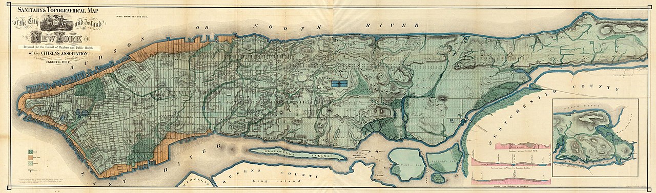


_crop.jpg/1280px-Broadway_Crowds_(5896264776)_crop.jpg)

.jpg/1280px-Central_Park_-_The_Pond_(48377220157).jpg)


.jpg/1280px-Times_Square_New_Year's_Eve_2023_Numbers_Ball_drop_(52579744724).jpg)
.jpg/1280px-New_York_Times_Building_-_Bottom_Portion_(48193462432).jpg)


_-_Central_Park,_NYC.jpg/1280px-Metropolitan_Museum_of_Art_(The_Met)_-_Central_Park,_NYC.jpg)
_-_Full_(48124330357).jpg/1280px-Madison_Square_Garden_(MSG)_-_Full_(48124330357).jpg)


.jpg/1280px-Court_of_first_model_tenement_house_in_New_York,_72nd_Street_and_First_Avenue,_Manhattan_(NYPL_b13668355-482804).jpg)


